Bridge Statistics for Fairgrove, Michigan (MI)
Condition, Traffic, Stress, Structural Evaluation, Project Costs
- National Bridge Inventory (NBI) Statistics
- 24Number of bridges
- 75ft / 22.9mTotal length
- $473,000Total costs
- 15,356Total average daily traffic
- 164Total average daily truck traffic
- 26,043Total future (year 2009) average daily traffic
- National Bridge Inventory (NBI) Registered Bridges for Fairgrove
- No street view available for this location
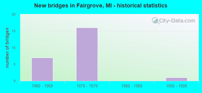
- New bridges - historical statistics
- 71960-1969
- 161970-1979
- 11990-1999

- Bridge Condition - Deck
- 5.0%Very good
- 40.0%Good
- 35.0%Satisfactory
- 20.0%Fair

- Bridge Condition - Superstructure
- 50.0%Good
- 25.0%Satisfactory
- 20.0%Fair
- 5.0%Poor

- Bridge Condition - Substructure
- 60.0%Good
- 35.0%Satisfactory
- 5.0%Fair

- Bridge Condition - Channel
- 4.2%Very good
- 33.3%Good
- 33.3%Satisfactory
- 29.2%Fair

- Bridge Condition - Culverts
- 50.0%Good
- 50.0%Satisfactory
Find on map >> Show street view
Structure Number: 10398, Location: 2.2 MI W OF FAIRGROVE (Lat: 43.523183, Lng: -83.586567), Route carried "on" structure: State highway 138, Year Built: 1969, Status: Open, Structure Length: 1.22m (4.00ft), Average Daily Traffic: 1,305 (year 2007), Truck Traffic: 6%, Average Future Daily Traffic: 2,112 (year 2018), Design Load: HS 20, Features Intersected: NORTHWEST DRAIN
Minimum Vertical Clearance: 30.48m (100.00ft), Kilometerpoint: 9.093, Lanes on structure: 2, Owner: State Highway Agency, Approaching Roadway Width: 12.5m (41.0ft), Material/Design: Steel, Design/Construction: Stringer/Multi-beam, Number Of Spans In Main Unit: 1, Length of Maximum Span: 12.2m (40.0ft), Curb or Sidewalk Widths: Left: 0.2m (0.7ft), Right: 0.2m (0.7ft), Curb-To-Curb Width: 12.6m (41.3ft), Out-to-Out Width: 13.3m (43.6ft)
Condition: Deck: Fair, Superstructure: Satisfactory, Substructure: Satisfactory, Channel: Satisfactory, Operating Rating: 61.6 metric tons, Method Used To Determine Operating Rating: Load Factor (LF) rating reported by rating factor (RF) method using MS18 loading, Inventory Rating: 36.9 metric tons, Method Used To Determine Inventory Rating: Load Factor (LF) rating reported by rating factor (RF) method using MS18 loading, Structural Evaluation: Equal to present minimum criteria, Deck Geometry: Better than present minimum criteria, Waterway Adequacy: Equal to present minimum criteria, Approach Roadway Alignment: Equal to present desirable criteria, Designated Inspection Frequency: Every 24 months, Inspection Date: June 2020, Bridge Improvement Cost: $14,000, Deck Structure Type: Concrete Cast-file-Place, Wearing Surface/Protective System: Wearing Surface: Epoxy Overlay
Find on map >> Show street view
Structure Number: 10399, Location: 1.0 MI W OF FAIRGROVE (Lat: 43.523356, Lng: -83.563064), Route carried "on" structure: State highway 138, Year Built: 1969, Status: Open, Structure Length: 1.22m (4.00ft), Average Daily Traffic: 1,201 (year 2007), Truck Traffic: 7%, Average Future Daily Traffic: 1,611 (year 2018), Design Load: HS 20, Features Intersected: NORTHWEST DRAIN
Minimum Vertical Clearance: 30.48m (100.00ft), Kilometerpoint: 10.994, Lanes on structure: 2, Base Highway Network: Yes (Inventory Route: 27, Subroute: 6), Owner: State Highway Agency, Approaching Roadway Width: 12.5m (41.0ft), Material/Design: Steel, Design/Construction: Stringer/Multi-beam, Number Of Spans In Main Unit: 1, Length of Maximum Span: 12.2m (40.0ft), Curb or Sidewalk Widths: Left: 0.2m (0.7ft), Right: 0.2m (0.7ft), Curb-To-Curb Width: 12.5m (41.0ft), Out-to-Out Width: 13.3m (43.6ft)
Condition: Deck: Satisfactory, Superstructure: Satisfactory, Substructure: Good, Channel: Fair, Operating Rating: 64.2 metric tons, Method Used To Determine Operating Rating: Load Factor (LF) rating reported by rating factor (RF) method using MS18 loading, Inventory Rating: 38.6 metric tons, Method Used To Determine Inventory Rating: Load Factor (LF) rating reported by rating factor (RF) method using MS18 loading, Structural Evaluation: Equal to present minimum criteria, Deck Geometry: Better than present minimum criteria, Waterway Adequacy: Equal to present minimum criteria, Approach Roadway Alignment: Equal to present desirable criteria, Designated Inspection Frequency: Every 24 months, Inspection Date: August 2020, Deck Structure Type: Concrete Cast-file-Place, Wearing Surface/Protective System: Wearing Surface: Epoxy Overlay
Find on map >> Show street view
Structure Number: 10461, Location: SEC 26-35 GILFORD TWP (Lat: 43.494131, Lng: -83.608714), Route carried "on" structure: County highway , Year Built: 1972, Status: Open, Structure Length: 0.79m (2.59ft), Average Daily Traffic: 1,865 (year 2009), Average Future Daily Traffic: 3,040 (year 2029), Design Load: HS 20, Features Intersected: NORTHWEST DRAIN, Facility Carried by Structure: GILFORD ROAD
Minimum Vertical Clearance: 30.48m (100.00ft), Kilometerpoint: 7.292, Lanes on structure: 2, Owner: County Highway Agency, Approaching Roadway Width: 9.1m (29.9ft), Material/Design: Prestressed concrete, Design/Construction: Box Beam or Girders - Multiple, Number Of Spans In Main Unit: 1, Length of Maximum Span: 7.5m (24.6ft), Curb-To-Curb Width: 11.0m (36.1ft), Out-to-Out Width: 11.2m (36.7ft)
Condition: Deck: Satisfactory, Superstructure: Good, Substructure: Good, Channel: Fair, Operating Rating: 75.5 metric tons, Method Used To Determine Operating Rating: Load Factor (LF) rating reported by rating factor (RF) method using MS18 loading, Inventory Rating: 45.0 metric tons, Method Used To Determine Inventory Rating: Load Factor (LF) rating reported by rating factor (RF) method using MS18 loading, Structural Evaluation: Better than present minimum criteria, Deck Geometry: Equal to present minimum criteria, Waterway Adequacy: Equal to present desirable criteria, Approach Roadway Alignment: Equal to present minimum criteria, Designated Inspection Frequency: Every 24 months, Inspection Date: May 2021, Deck Structure Type: Concrete Precast Panels, Wearing Surface/Protective System: Wearing Surface: Bituminous
Find on map >> Show street view
Structure Number: 10462, Location: SEC 26-35 GILFORD TWP (Lat: 43.494192, Lng: -83.601903), Route carried "on" structure: County highway , Year Built: 1971, Status: Open, Structure Length: 0.76m (2.49ft), Average Daily Traffic: 1,237 (year 2006), Average Future Daily Traffic: 1,875 (year 2027), Design Load: HS 20, Features Intersected: HOBART OR BR 3 NW DRAIN, Facility Carried by Structure: GILFORD ROAD
Minimum Vertical Clearance: 30.48m (100.00ft), Kilometerpoint: 7.843, Lanes on structure: 2, Owner: County Highway Agency, Approaching Roadway Width: 8.5m (27.9ft), Skew: 2 degrees, Material/Design: Prestressed concrete, Design/Construction: Box Beam or Girders - Multiple, Number Of Spans In Main Unit: 1, Length of Maximum Span: 7.2m (23.6ft), Curb-To-Curb Width: 11.0m (36.1ft), Out-to-Out Width: 11.1m (36.4ft)
Condition: Deck: Satisfactory, Superstructure: Good, Substructure: Good, Channel: Fair, Operating Rating: 97.2 metric tons, Method Used To Determine Operating Rating: Load Factor (LF) rating reported by rating factor (RF) method using MS18 loading, Inventory Rating: 58.6 metric tons, Method Used To Determine Inventory Rating: Load Factor (LF) rating reported by rating factor (RF) method using MS18 loading, Structural Evaluation: Better than present minimum criteria, Deck Geometry: Equal to present minimum criteria, Waterway Adequacy: Equal to present desirable criteria, Approach Roadway Alignment: Better than present minimum criteria, Designated Inspection Frequency: Every 24 months, Inspection Date: May 2020, Deck Structure Type: Concrete Precast Panels, Wearing Surface/Protective System: Wearing Surface: Bituminous
Find on map >> Show street view
Structure Number: 10463, Location: SEC 29-32 FAIRGROVE TWP (Lat: 43.494539, Lng: -83.558300), Route carried "on" structure: County highway , Year Built: 1972, Status: Open, Structure Length: 0.73m (2.40ft), Average Daily Traffic: 1,700 (year 2009), Average Future Daily Traffic: 3,070 (year 2029), Design Load: HS 20, Features Intersected: BR 1 NORTHWEST DRAIN, Facility Carried by Structure: GILFORD ROAD
Minimum Vertical Clearance: 30.48m (100.00ft), Kilometerpoint: 11.369, Lanes on structure: 2, Owner: County Highway Agency, Approaching Roadway Width: 9.1m (29.9ft), Material/Design: Prestressed concrete, Design/Construction: Box Beam or Girders - Multiple, Number Of Spans In Main Unit: 1, Length of Maximum Span: 6.9m (22.6ft), Curb-To-Curb Width: 10.6m (34.8ft), Out-to-Out Width: 11.1m (36.4ft)
Condition: Deck: Fair, Superstructure: Poor, Substructure: Good, Channel: Fair, Operating Rating: 78.7 metric tons, Method Used To Determine Operating Rating: Load Factor (LF) rating reported by rating factor (RF) method using MS18 loading, Inventory Rating: 47.3 metric tons, Method Used To Determine Inventory Rating: Load Factor (LF) rating reported by rating factor (RF) method using MS18 loading, Structural Evaluation: Meets minimum limits, Deck Geometry: Equal to present minimum criteria, Waterway Adequacy: Equal to present desirable criteria, Approach Roadway Alignment: Equal to present desirable criteria, Designated Inspection Frequency: Every 12 months, Inspection Date: October 2021, Deck Structure Type: Concrete Precast Panels, Wearing Surface/Protective System: Wearing Surface: Bituminous
Find on map >> Show street view
Structure Number: 10469, Location: SEC 15-22 FAIRGROVE TWP (Lat: 43.523806, Lng: -83.507500), Route carried "on" structure: County highway 7970, Year Built: 1971, Status: Open, Structure Length: 0.79m (2.59ft), Average Daily Traffic: 1,650 (year 2009), Average Future Daily Traffic: 2,980 (year 2029), Design Load: HS 20, Features Intersected: ALLEN EXTENSION DRAIN, Facility Carried by Structure: FAIRGROVE ROAD
Minimum Vertical Clearance: 30.48m (100.00ft), Kilometerpoint: 14.431, Lanes on structure: 2, Owner: County Highway Agency, Approaching Roadway Width: 9.8m (32.2ft), Skew: 2 degrees, Material/Design: Prestressed concrete, Design/Construction: Box Beam or Girders - Multiple, Number Of Spans In Main Unit: 1, Length of Maximum Span: 7.5m (24.6ft), Curb-To-Curb Width: 10.6m (34.8ft), Out-to-Out Width: 11.1m (36.4ft)
Condition: Deck: Good, Superstructure: Good, Substructure: Good, Channel: Good, Operating Rating: 75.5 metric tons, Method Used To Determine Operating Rating: Load Factor (LF) rating reported by rating factor (RF) method using MS18 loading, Inventory Rating: 45.0 metric tons, Method Used To Determine Inventory Rating: Load Factor (LF) rating reported by rating factor (RF) method using MS18 loading, Structural Evaluation: Better than present minimum criteria, Deck Geometry: Equal to present minimum criteria, Waterway Adequacy: Equal to present desirable criteria, Approach Roadway Alignment: Equal to present desirable criteria, Designated Inspection Frequency: Every 24 months, Inspection Date: May 2021, Deck Structure Type: Concrete Precast Panels, Wearing Surface/Protective System: Wearing Surface: Bituminous
Find on map >> Show street view
Structure Number: 10472, Location: SEC 1 GILFORD TWP (Lat: 43.565517, Lng: -83.603136), Route carried "on" structure: County highway , Year Built: 1962, Status: Posted for load, Structure Length: 1.19m (3.90ft), Average Daily Traffic: 500 (year 2009), Average Future Daily Traffic: 900 (year 2009), Design Load: H 15, Features Intersected: NORTHWEST DRAIN OUTLET 3, Facility Carried by Structure: AKRON ROAD
Minimum Vertical Clearance: 30.48m (100.00ft), Kilometerpoint: 6.439, Lanes on structure: 2, Owner: County Highway Agency, Approaching Roadway Width: 9.8m (32.2ft), Material/Design: Steel, Design/Construction: Stringer/Multi-beam, Number Of Spans In Main Unit: 1, Length of Maximum Span: 11.1m (36.4ft), Curb-To-Curb Width: 8.2m (26.9ft), Out-to-Out Width: 8.9m (29.2ft)
Condition: Deck: Satisfactory, Superstructure: Fair, Substructure: Satisfactory, Channel: Fair, Operating Rating: 74.8 metric tons, Method Used To Determine Operating Rating: Load Factor (LF) rating reported by rating factor (RF) method using MS18 loading, Inventory Rating: 45.0 metric tons, Method Used To Determine Inventory Rating: Load Factor (LF) rating reported by rating factor (RF) method using MS18 loading, Structural Evaluation: Somewhat better than minimum adequacy, Deck Geometry: Somewhat better than minimum adequacy, Waterway Adequacy: Better than present minimum criteria, Approach Roadway Alignment: Equal to present desirable criteria, Bridge Posting: Required (Relationship of Operating Rating to Maximum Legal Load: 0.1 - 9.9% below), Length Of Structure Improvement: 1.15m (3.77ft), Designated Inspection Frequency: Every 12 months, Inspection Date: May 2021, Bridge Improvement Cost: $178,000, Roadway Improvement Cost: $10,000, Total Project Cost: $238,000, Deck Structure Type: Concrete Cast-file-Place, Wearing Surface/Protective System: Wearing Surface: Bituminous
Find on map >> Show street view
Structure Number: 10473, Location: SEC 31 AKRON TWP (Lat: 43.565519, Lng: -83.583164), Route carried "on" structure: County highway , Year Built: 1971, Status: Open, Structure Length: 0.73m (2.40ft), Average Daily Traffic: 700 (year 2009), Average Future Daily Traffic: 1,300 (year 2029), Design Load: HS 20, Features Intersected: SOUTHGATE DRAIN, Facility Carried by Structure: AKRON ROAD
Minimum Vertical Clearance: 30.48m (100.00ft), Kilometerpoint: 8.053, Lanes on structure: 2, Owner: County Highway Agency, Approaching Roadway Width: 9.1m (29.9ft), Material/Design: Prestressed concrete, Design/Construction: Box Beam or Girders - Multiple, Number Of Spans In Main Unit: 1, Length of Maximum Span: 6.1m (20.0ft), Curb-To-Curb Width: 11.0m (36.1ft), Out-to-Out Width: 11.1m (36.4ft)
Condition: Deck: Satisfactory, Superstructure: Good, Substructure: Good, Channel: Good, Operating Rating: 79.1 metric tons, Method Used To Determine Operating Rating: Load Factor (LF) rating reported by rating factor (RF) method using MS18 loading, Inventory Rating: 47.3 metric tons, Method Used To Determine Inventory Rating: Load Factor (LF) rating reported by rating factor (RF) method using MS18 loading, Structural Evaluation: Better than present minimum criteria, Deck Geometry: Better than present minimum criteria, Waterway Adequacy: Equal to present minimum criteria, Approach Roadway Alignment: Equal to present minimum criteria, Designated Inspection Frequency: Every 24 months, Inspection Date: April 2021, Deck Structure Type: Concrete Precast Panels, Wearing Surface/Protective System: Wearing Surface: Bituminous
Find on map >> Show street view
Structure Number: 105, Location: SEC 31 FAIRGROVE TWP (Lat: 43.486258, Lng: -83.581828), Route carried "on" structure: County highway 7921, Year Built: 1971, Status: Open, Structure Length: 0.82m (2.69ft), Average Daily Traffic: 1,000 (year 2009), Average Future Daily Traffic: 1,805 (year 2029), Design Load: HS 20, Features Intersected: HOBART OR BR 3 NW DRAIN, Facility Carried by Structure: VASSAR ROAD
Minimum Vertical Clearance: 30.48m (100.00ft), Kilometerpoint: 10.376, Lanes on structure: 2, Owner: County Highway Agency, Approaching Roadway Width: 10.4m (34.1ft), Skew: 3 degrees, Material/Design: Prestressed concrete, Design/Construction: Box Beam or Girders - Multiple, Number Of Spans In Main Unit: 1, Length of Maximum Span: 7.5m (24.6ft), Curb-To-Curb Width: 10.6m (34.8ft), Out-to-Out Width: 11.1m (36.4ft)
Condition: Deck: Very good, Superstructure: Good, Substructure: Good, Channel: Good, Operating Rating: 89.5 metric tons, Method Used To Determine Operating Rating: Load Factor (LF), Inventory Rating: 53.6 metric tons, Method Used To Determine Inventory Rating: Load Factor (LF), Structural Evaluation: Better than present minimum criteria, Deck Geometry: Equal to present minimum criteria, Waterway Adequacy: Equal to present desirable criteria, Approach Roadway Alignment: Equal to present desirable criteria, Designated Inspection Frequency: Every 24 months, Inspection Date: May 2021, Deck Structure Type: Concrete Precast Panels, Wearing Surface/Protective System: Wearing Surface: Bituminous
Find on map >> Show street view
Structure Number: 10501, Location: SEC 18 FAIRGROVE TWP (Lat: 43.533139, Lng: -83.582722), Route carried "on" structure: County highway 7921, Year Built: 1971, Status: Open, Structure Length: 1.04m (3.41ft), Average Daily Traffic: 650 (year 2009), Average Future Daily Traffic: 1,170 (year 2029), Design Load: HS 20, Features Intersected: NORTHWEST DRAIN, Facility Carried by Structure: VASSAR ROAD
Minimum Vertical Clearance: 30.48m (100.00ft), Kilometerpoint: 15.584, Lanes on structure: 2, Owner: County Highway Agency, Approaching Roadway Width: 9.8m (32.2ft), Material/Design: Prestressed concrete, Design/Construction: Box Beam or Girders - Multiple, Number Of Spans In Main Unit: 1, Length of Maximum Span: 9.9m (32.5ft), Curb-To-Curb Width: 11.0m (36.1ft), Out-to-Out Width: 11.1m (36.4ft)
Condition: Deck: Good, Superstructure: Good, Substructure: Good, Channel: Satisfactory, Operating Rating: 63.8 metric tons, Method Used To Determine Operating Rating: Load Factor (LF), Inventory Rating: 38.2 metric tons, Method Used To Determine Inventory Rating: Load Factor (LF), Structural Evaluation: Better than present minimum criteria, Deck Geometry: Better than present minimum criteria, Waterway Adequacy: Better than present minimum criteria, Approach Roadway Alignment: Equal to present desirable criteria, Designated Inspection Frequency: Every 24 months, Inspection Date: May 2021, Deck Structure Type: Concrete Precast Panels, Wearing Surface/Protective System: Wearing Surface: Bituminous
Find on map >> Show street view
Structure Number: 10502, Location: SEC 7-18 FAIRGROVE TWP (Lat: 43.537675, Lng: -83.581339), Route carried "on" structure: County highway 7921, Year Built: 1971, Status: Open, Structure Length: 1.40m (4.59ft), Average Daily Traffic: 530 (year 2009), Average Future Daily Traffic: 955 (year 2029), Design Load: HS 20, Features Intersected: NORTHWEST DRAIN, Facility Carried by Structure: VASSAR ROAD
Minimum Vertical Clearance: 30.48m (100.00ft), Kilometerpoint: 9.520, Lanes on structure: 2, Owner: County Highway Agency, Approaching Roadway Width: 9.8m (32.2ft), Skew: 1 degrees, Material/Design: Prestressed concrete, Design/Construction: Box Beam or Girders - Multiple, Number Of Spans In Main Unit: 1, Length of Maximum Span: 13.6m (44.6ft), Curb-To-Curb Width: 11.0m (36.1ft), Out-to-Out Width: 11.1m (36.4ft)
Condition: Deck: Good, Superstructure: Satisfactory, Substructure: Good, Channel: Satisfactory, Operating Rating: 54.4 metric tons, Method Used To Determine Operating Rating: Field evaluation and documented engineering judgment, Inventory Rating: 32.6 metric tons, Method Used To Determine Inventory Rating: Field evaluation and documented engineering judgment, Structural Evaluation: Equal to present minimum criteria, Deck Geometry: Better than present minimum criteria, Waterway Adequacy: Better than present minimum criteria, Approach Roadway Alignment: Better than present minimum criteria, Designated Inspection Frequency: Every 24 months, Inspection Date: May 2021, Deck Structure Type: Concrete Precast Panels, Wearing Surface/Protective System: Wearing Surface: Bituminous
Find on map >> Show street view
Structure Number: 10504, Location: SEC 4-5 JUNIATA TWP (Lat: 43.478903, Lng: -83.543003), Route carried "on" structure: County highway , Year Built: 1971, Status: Open, Structure Length: 0.73m (2.40ft), Average Daily Traffic: 600 (year 2009), Average Future Daily Traffic: 1,085 (year 2029), Design Load: HS 20, Features Intersected: BR 1 NORTHWEST DRAIN, Facility Carried by Structure: HIGGINS ROAD
Minimum Vertical Clearance: 30.48m (100.00ft), Kilometerpoint: 9.439, Lanes on structure: 2, Owner: County Highway Agency, Approaching Roadway Width: 9.1m (29.9ft), Material/Design: Prestressed concrete, Design/Construction: Box Beam or Girders - Multiple, Number Of Spans In Main Unit: 1, Length of Maximum Span: 6.9m (22.6ft), Curb-To-Curb Width: 10.6m (34.8ft), Out-to-Out Width: 11.1m (36.4ft)
Condition: Deck: Satisfactory, Superstructure: Satisfactory, Substructure: Satisfactory, Channel: Satisfactory, Operating Rating: 78.1 metric tons, Method Used To Determine Operating Rating: Load Factor (LF) rating reported by rating factor (RF) method using MS18 loading, Inventory Rating: 46.7 metric tons, Method Used To Determine Inventory Rating: Load Factor (LF) rating reported by rating factor (RF) method using MS18 loading, Structural Evaluation: Equal to present minimum criteria, Deck Geometry: Equal to present minimum criteria, Waterway Adequacy: Equal to present desirable criteria, Approach Roadway Alignment: Somewhat better than minimum adequacy, Designated Inspection Frequency: Every 24 months, Inspection Date: May 2020, Deck Structure Type: Concrete Precast Panels, Wearing Surface/Protective System: Wearing Surface: Bituminous
Find on map >> Show street view
Structure Number: 10535, Location: SEC 30-31 AKRON TWP (Lat: 43.579994, Lng: -83.583489), Route carried "on" structure: ServiceCounty highway , Year Built: 1967, Status: Open, Structure Length: 0.94m (3.08ft), Average Daily Traffic: 225 (year 2009), Average Future Daily Traffic: 400 (year 2029), Design Load: H 15, Features Intersected: SOUTHGATE DRAIN, Facility Carried by Structure: ELMWOOD ROAD
Minimum Vertical Clearance: 30.48m (100.00ft), Kilometerpoint: 6.856, Lanes on structure: 2, Owner: County Highway Agency, Approaching Roadway Width: 8.5m (27.9ft), Material/Design: Steel, Design/Construction: Stringer/Multi-beam, Number Of Spans In Main Unit: 1, Length of Maximum Span: 9.0m (29.5ft), Curb-To-Curb Width: 9.0m (29.5ft), Out-to-Out Width: 9.1m (29.9ft)
Condition: Deck: Good, Superstructure: Fair, Substructure: Satisfactory, Channel: Good, Operating Rating: 66.4 metric tons, Method Used To Determine Operating Rating: Load Factor (LF) rating reported by rating factor (RF) method using MS18 loading, Inventory Rating: 39.9 metric tons, Method Used To Determine Inventory Rating: Load Factor (LF) rating reported by rating factor (RF) method using MS18 loading, Structural Evaluation: Somewhat better than minimum adequacy, Deck Geometry: Equal to present minimum criteria, Waterway Adequacy: Better than present minimum criteria, Approach Roadway Alignment: Equal to present minimum criteria, Designated Inspection Frequency: Every 24 months, Inspection Date: April 2021, Deck Structure Type: Concrete Cast-file-Place, Wearing Surface/Protective System: Wearing Surface: Monolithic Concrete
Find on map >> Show street view
Structure Number: 10581, Location: SEC 31 FAIRGROVE TWP (Lat: 43.479894, Lng: -83.578772), Route carried "on" structure: ServiceCounty highway , Year Built: 1979, Status: Open, Structure Length: 0.79m (2.59ft), Average Daily Traffic: 85 (year 2009), Average Future Daily Traffic: 150 (year 2029), Design Load: H 20, Features Intersected: HOBART OR BR 3 NW DRAIN, Facility Carried by Structure: VAN GIESEN ROAD
Minimum Vertical Clearance: 30.48m (100.00ft), Kilometerpoint: 9.710, Lanes on structure: 2, Owner: County Highway Agency, Approaching Roadway Width: 7.9m (25.9ft), Skew: 3 degrees, Material/Design: Steel, Design/Construction: Culvert, Number Of Spans In Main Unit: 2, Length of Maximum Span: 3.6m (11.8ft)
Condition: Channel: Satisfactory, Culverts: Satisfactory, Operating Rating: 97.2 metric tons, Method Used To Determine Operating Rating: Load Factor (LF) rating reported by rating factor (RF) method using MS18 loading, Inventory Rating: 97.2 metric tons, Method Used To Determine Inventory Rating: Load Factor (LF) rating reported by rating factor (RF) method using MS18 loading, Structural Evaluation: Equal to present minimum criteria, Waterway Adequacy: Equal to present desirable criteria, Approach Roadway Alignment: Equal to present desirable criteria, Designated Inspection Frequency: Every 24 months, Inspection Date: May 2021
Find on map >> Show street view
Structure Number: 10583, Location: SEC 16 FAIRGROVE TWP (Lat: 43.530864, Lng: -83.528914), Route carried "on" structure: ServiceCounty highway , Year Built: 1967, Status: Open, Structure Length: 0.76m (2.49ft), Average Daily Traffic: 220 (year 2009), Average Future Daily Traffic: 400 (year 2029), Design Load: H 15, Features Intersected: ALLEN EXTN DRAIN, Facility Carried by Structure: SHREEVES ROAD
Minimum Vertical Clearance: 30.48m (100.00ft), Kilometerpoint: 2.781, Lanes on structure: 2, Owner: County Highway Agency, Approaching Roadway Width: 7.9m (25.9ft), Material/Design: Steel, Design/Construction: Stringer/Multi-beam, Number Of Spans In Main Unit: 1, Length of Maximum Span: 7.2m (23.6ft), Curb-To-Curb Width: 7.9m (25.9ft), Out-to-Out Width: 8.4m (27.6ft)
Condition: Deck: Good, Superstructure: Good, Substructure: Good, Channel: Good, Operating Rating: 66.7 metric tons, Method Used To Determine Operating Rating: Load Factor (LF) rating reported by rating factor (RF) method using MS18 loading, Inventory Rating: 39.9 metric tons, Method Used To Determine Inventory Rating: Load Factor (LF) rating reported by rating factor (RF) method using MS18 loading, Structural Evaluation: Better than present minimum criteria, Deck Geometry: Somewhat better than minimum adequacy, Waterway Adequacy: Equal to present desirable criteria, Approach Roadway Alignment: Equal to present desirable criteria, Designated Inspection Frequency: Every 24 months, Inspection Date: May 2021, Deck Structure Type: Concrete Cast-file-Place, Wearing Surface/Protective System: Wearing Surface: Bituminous
Find on map >> Show street view
Structure Number: 10584, Location: SEC 17-18 FAIRGROVE TWP (Lat: 43.525744, Lng: -83.563203), Route carried "on" structure: ServiceCounty highway , Year Built: 1972, Status: Open, Structure Length: 1.04m (3.41ft), Average Daily Traffic: 295 (year 2009), Average Future Daily Traffic: 530 (year 2029), Design Load: HS 20, Features Intersected: BR #1 NORTHWEST DRAIN, Facility Carried by Structure: KIRK ROAD
Minimum Vertical Clearance: 30.48m (100.00ft), Kilometerpoint: 18.236, Lanes on structure: 2, Owner: County Highway Agency, Approaching Roadway Width: 9.1m (29.9ft), Material/Design: Prestressed concrete, Design/Construction: Box Beam or Girders - Multiple, Number Of Spans In Main Unit: 1, Length of Maximum Span: 9.9m (32.5ft), Curb-To-Curb Width: 10.9m (35.8ft), Out-to-Out Width: 11.1m (36.4ft)
Condition: Deck: Fair, Superstructure: Fair, Substructure: Satisfactory, Channel: Fair, Operating Rating: 61.6 metric tons, Method Used To Determine Operating Rating: Load Factor (LF) rating reported by rating factor (RF) method using MS18 loading, Inventory Rating: 36.9 metric tons, Method Used To Determine Inventory Rating: Load Factor (LF) rating reported by rating factor (RF) method using MS18 loading, Structural Evaluation: Somewhat better than minimum adequacy, Deck Geometry: Better than present minimum criteria, Waterway Adequacy: Better than present minimum criteria, Approach Roadway Alignment: Equal to present desirable criteria, Designated Inspection Frequency: Every 24 months, Inspection Date: May 2020, Deck Structure Type: Concrete Precast Panels, Wearing Surface/Protective System: Wearing Surface: Bituminous
Find on map >> Show street view
Structure Number: 10585, Location: SEC 15-16 FAIRGROVE TWP (Lat: 43.537125, Lng: -83.523803), Route carried "on" structure: ServiceCounty highway , Year Built: 1979, Status: Open, Structure Length: 0.66m (2.17ft), Average Daily Traffic: 345 (year 2009), Average Future Daily Traffic: 520 (year 2029), Design Load: H 20, Features Intersected: ALLEN EXTN DRAIN, Facility Carried by Structure: RINGLE ROAD
Minimum Vertical Clearance: 30.48m (100.00ft), Kilometerpoint: 15.928, Lanes on structure: 2, Owner: County Highway Agency, Approaching Roadway Width: 9.1m (29.9ft), Material/Design: Steel, Design/Construction: Culvert, Number Of Spans In Main Unit: 1, Length of Maximum Span: 6.6m (21.7ft)
Condition: Channel: Satisfactory, Culverts: Satisfactory, Operating Rating: 94.0 metric tons, Method Used To Determine Operating Rating: Load Factor (LF) rating reported by rating factor (RF) method using MS18 loading, Inventory Rating: 82.9 metric tons, Method Used To Determine Inventory Rating: Load Factor (LF) rating reported by rating factor (RF) method using MS18 loading, Structural Evaluation: Equal to present minimum criteria, Waterway Adequacy: Equal to present desirable criteria, Approach Roadway Alignment: Equal to present desirable criteria, Designated Inspection Frequency: Every 24 months, Inspection Date: May 2021
Find on map >> Show street view
Structure Number: 10586, Location: SEC 15-16 FAIRGROVE TWP (Lat: 43.524806, Lng: -83.523558), Route carried "on" structure: ServiceCounty highway , Year Built: 1979, Status: Open, Structure Length: 0.66m (2.17ft), Average Daily Traffic: 345 (year 2009), Average Future Daily Traffic: 520 (year 2029), Design Load: H 20, Features Intersected: ALLEN EXTN DRAIN, Facility Carried by Structure: RINGLE ROAD
Minimum Vertical Clearance: 30.48m (100.00ft), Kilometerpoint: 14.560, Lanes on structure: 2, Owner: County Highway Agency, Approaching Roadway Width: 9.1m (29.9ft), Material/Design: Steel, Design/Construction: Culvert, Number Of Spans In Main Unit: 1, Length of Maximum Span: 6.6m (21.7ft), Curb-To-Curb Width: 9.1m (29.9ft), Out-to-Out Width: 9.1m (29.9ft)
Condition: Channel: Good, Culverts: Good, Operating Rating: 47.0 metric tons, Method Used To Determine Operating Rating: Load Factor (LF) rating reported by rating factor (RF) method using MS18 loading, Inventory Rating: 40.2 metric tons, Method Used To Determine Inventory Rating: Load Factor (LF) rating reported by rating factor (RF) method using MS18 loading, Structural Evaluation: Better than present minimum criteria, Deck Geometry: Equal to present minimum criteria, Waterway Adequacy: Equal to present desirable criteria, Approach Roadway Alignment: Better than present minimum criteria, Designated Inspection Frequency: Every 24 months, Inspection Date: May 2021
Find on map >> Show street view
Structure Number: 10589, Location: SEC 15 FAIRGROVE TWP (Lat: 43.529347, Lng: -83.513744), Route carried "on" structure: ServiceCounty highway , Year Built: 1979, Status: Open, Structure Length: 0.66m (2.17ft), Average Daily Traffic: 330 (year 2009), Average Future Daily Traffic: 590 (year 2029), Design Load: H 20, Features Intersected: ALLEN EXTN DRAIN, Facility Carried by Structure: MERRY ROAD
Minimum Vertical Clearance: 30.48m (100.00ft), Kilometerpoint: 5.441, Lanes on structure: 2, Owner: County Highway Agency, Approaching Roadway Width: 8.5m (27.9ft), Material/Design: Steel, Design/Construction: Culvert, Number Of Spans In Main Unit: 1, Length of Maximum Span: 6.6m (21.7ft)
Condition: Channel: Satisfactory, Culverts: Good, Operating Rating: 34.3 metric tons, Method Used To Determine Operating Rating: Load Factor (LF) rating reported by rating factor (RF) method using MS18 loading, Inventory Rating: 24.3 metric tons, Method Used To Determine Inventory Rating: Load Factor (LF) rating reported by rating factor (RF) method using MS18 loading, Structural Evaluation: Equal to present minimum criteria, Waterway Adequacy: Equal to present desirable criteria, Approach Roadway Alignment: Equal to present desirable criteria, Designated Inspection Frequency: Every 24 months, Inspection Date: May 2021
Find on map >> Show street view
Structure Number: 10596, Location: SEC 13 GILFORD TWP (Lat: 43.530400, Lng: -83.585694), Route carried "on" structure: ServiceCounty highway , Year Built: 1972, Status: Open, Structure Length: 1.04m (3.41ft), Average Daily Traffic: 80 (year 2009), Average Future Daily Traffic: 140 (year 2029), Design Load: HS 20, Features Intersected: NORTHWEST DRAIN, Facility Carried by Structure: HICKEY ROAD
Minimum Vertical Clearance: 30.48m (100.00ft), Kilometerpoint: 1.362, Lanes on structure: 2, Owner: County Highway Agency, Approaching Roadway Width: 9.8m (32.2ft), Material/Design: Prestressed concrete, Design/Construction: Box Beam or Girders - Multiple, Number Of Spans In Main Unit: 1, Length of Maximum Span: 9.9m (32.5ft), Curb-To-Curb Width: 10.9m (35.8ft), Out-to-Out Width: 11.1m (36.4ft)
Condition: Deck: Satisfactory, Superstructure: Good, Substructure: Satisfactory, Channel: Satisfactory, Operating Rating: 78.4 metric tons, Method Used To Determine Operating Rating: Load Factor (LF) rating reported by rating factor (RF) method using MS18 loading, Inventory Rating: 45.0 metric tons, Method Used To Determine Inventory Rating: Load Factor (LF) rating reported by rating factor (RF) method using MS18 loading, Structural Evaluation: Equal to present minimum criteria, Deck Geometry: Superior to present desirable criteria, Waterway Adequacy: Equal to present desirable criteria, Approach Roadway Alignment: Equal to present desirable criteria, Designated Inspection Frequency: Every 24 months, Inspection Date: May 2021, Deck Structure Type: Concrete Precast Panels, Wearing Surface/Protective System: Wearing Surface: Bituminous
Find on map >> Show street view
Structure Number: 10598, Location: SEC 1-12 GILFORD TWP (Lat: 43.552028, Lng: -83.598008), Route carried "on" structure: ServiceCounty highway , Year Built: 1963, Status: Posted for load, Structure Length: 1.16m (3.81ft), Average Daily Traffic: 105 (year 2009), Average Future Daily Traffic: 190 (year 2029), Design Load: H 15, Features Intersected: NORTHWEST DRAIN, Facility Carried by Structure: DUTCHER ROAD
Minimum Vertical Clearance: 30.48m (100.00ft), Kilometerpoint: 8.174, Lanes on structure: 2, Owner: County Highway Agency, Approaching Roadway Width: 8.5m (27.9ft), Material/Design: Steel, Design/Construction: Stringer/Multi-beam, Number Of Spans In Main Unit: 1, Length of Maximum Span: 11.1m (36.4ft), Curb-To-Curb Width: 7.5m (24.6ft), Out-to-Out Width: 8.0m (26.2ft)
Condition: Deck: Good, Superstructure: Fair, Substructure: Good, Channel: Good, Operating Rating: 31.1 metric tons, Method Used To Determine Operating Rating: Load Factor (LF) rating reported by rating factor (RF) method using MS18 loading, Inventory Rating: 18.5 metric tons, Method Used To Determine Inventory Rating: Load Factor (LF) rating reported by rating factor (RF) method using MS18 loading, Structural Evaluation: Somewhat better than minimum adequacy, Deck Geometry: Somewhat better than minimum adequacy, Waterway Adequacy: Equal to present desirable criteria, Approach Roadway Alignment: Equal to present desirable criteria, Bridge Posting: Required (Relationship of Operating Rating to Maximum Legal Load: > 39.9% below), Length Of Structure Improvement: 1.15m (3.77ft), Designated Inspection Frequency: Every 24 months, Inspection Date: May 2021, Bridge Improvement Cost: $190,000, Roadway Improvement Cost: $20,000, Total Project Cost: $235,000, Deck Structure Type: Concrete Cast-file-Place, Wearing Surface/Protective System: Wearing Surface: Monolithic Concrete
Find on map >> Show street view
Structure Number: 10606, Location: SEC 25-26 GILFORD TWP (Lat: 43.502317, Lng: -83.602047), Route carried "on" structure: ServiceCounty highway , Year Built: 1972, Status: Open, Structure Length: 1.04m (3.41ft), Average Daily Traffic: 180 (year 2009), Average Future Daily Traffic: 325 (year 2029), Design Load: HS 20, Features Intersected: NORTHWEST DRAIN, Facility Carried by Structure: GARNER ROAD
Minimum Vertical Clearance: 30.48m (100.00ft), Kilometerpoint: 0.908, Lanes on structure: 2, Owner: County Highway Agency, Approaching Roadway Width: 9.1m (29.9ft), Material/Design: Prestressed concrete, Design/Construction: Box Beam or Girders - Multiple, Number Of Spans In Main Unit: 1, Length of Maximum Span: 9.9m (32.5ft), Curb-To-Curb Width: 11.0m (36.1ft), Out-to-Out Width: 11.2m (36.7ft)
Condition: Deck: Good, Superstructure: Good, Substructure: Fair, Channel: Fair, Operating Rating: 73.2 metric tons, Method Used To Determine Operating Rating: Load Factor (LF) rating reported by rating factor (RF) method using MS18 loading, Inventory Rating: 40.2 metric tons, Method Used To Determine Inventory Rating: Load Factor (LF) rating reported by rating factor (RF) method using MS18 loading, Structural Evaluation: Somewhat better than minimum adequacy, Deck Geometry: Equal to present desirable criteria, Waterway Adequacy: Equal to present desirable criteria, Approach Roadway Alignment: Better than present minimum criteria, Designated Inspection Frequency: Every 24 months, Inspection Date: October 2021, Deck Structure Type: Concrete Precast Panels, Wearing Surface/Protective System: Wearing Surface: Bituminous
Find on map >> Show street view
Structure Number: 10607, Location: SEC 11-12 GILFORD TWP (Lat: 43.548333, Lng: -83.602894), Route carried "on" structure: ServiceCounty highway , Year Built: 1999, Status: Open, Structure Length: 1.92m (6.30ft), Average Daily Traffic: 98 (year 2009), Truck Traffic: 3%, Average Future Daily Traffic: 175 (year 2029), Design Load: HS 20, Features Intersected: NORTHWEST DRAIN OUTLET 1, Facility Carried by Structure: GARNER ROAD
Minimum Vertical Clearance: 30.48m (100.00ft), Kilometerpoint: 6.019, Lanes on structure: 2, Owner: County Highway Agency, Approaching Roadway Width: 9.1m (29.9ft), Material/Design: Prestressed concrete, Design/Construction: Box Beam or Girders - Multiple, Number Of Spans In Main Unit: 1, Length of Maximum Span: 18.8m (61.7ft), Curb-To-Curb Width: 9.9m (32.5ft), Out-to-Out Width: 10.5m (34.4ft)
Condition: Deck: Good, Superstructure: Good, Substructure: Good, Channel: Good, Operating Rating: 81.3 metric tons, Method Used To Determine Operating Rating: Load Factor (LF) rating reported by rating factor (RF) method using MS18 loading, Inventory Rating: 48.6 metric tons, Method Used To Determine Inventory Rating: Load Factor (LF) rating reported by rating factor (RF) method using MS18 loading, Structural Evaluation: Better than present minimum criteria, Deck Geometry: Superior to present desirable criteria, Waterway Adequacy: Equal to present desirable criteria, Approach Roadway Alignment: Equal to present desirable criteria, Designated Inspection Frequency: Every 24 months, Inspection Date: May 2021, Deck Structure Type: Concrete Precast Panels, Wearing Surface/Protective System: Wearing Surface: Bituminous, Membrane: Preformed Fabric, Deck Protection: Epoxy Coated Reinforcing
Find on map >> Show street view
Structure Number: 10608, Location: SEC 1-2 GILFORD TWP (Lat: 43.565358, Lng: -83.603283), Route carried "on" structure: ServiceCounty highway , Year Built: 1962, Status: Open, Structure Length: 0.85m (2.79ft), Average Daily Traffic: 110 (year 2009), Average Future Daily Traffic: 200 (year 2029), Design Load: H 20, Features Intersected: NORTHWEST DRAIN OUTLET 2, Facility Carried by Structure: GARNER ROAD
Minimum Vertical Clearance: 30.48m (100.00ft), Kilometerpoint: 7.910, Lanes on structure: 2, Owner: County Highway Agency, Approaching Roadway Width: 9.8m (32.2ft), Material/Design: Steel, Design/Construction: Stringer/Multi-beam, Number Of Spans In Main Unit: 1, Length of Maximum Span: 8.1m (26.6ft), Curb-To-Curb Width: 8.2m (26.9ft), Out-to-Out Width: 8.9m (29.2ft)
Condition: Deck: Fair, Superstructure: Satisfactory, Substructure: Satisfactory, Channel: Very good, Operating Rating: 55.4 metric tons, Method Used To Determine Operating Rating: Load Factor (LF) rating reported by rating factor (RF) method using MS18 loading, Inventory Rating: 33.0 metric tons, Method Used To Determine Inventory Rating: Load Factor (LF) rating reported by rating factor (RF) method using MS18 loading, Structural Evaluation: Equal to present minimum criteria, Deck Geometry: Somewhat better than minimum adequacy, Waterway Adequacy: Equal to present desirable criteria, Approach Roadway Alignment: Somewhat better than minimum adequacy, Designated Inspection Frequency: Every 24 months, Inspection Date: May 2021, Deck Structure Type: Concrete Cast-file-Place, Wearing Surface/Protective System: Wearing Surface: Monolithic Concrete