Bridge Statistics for Fairlawn, Virginia (VA)
Condition, Traffic, Stress, Structural Evaluation, Project Costs
- National Bridge Inventory (NBI) Statistics
- 11Number of bridges
- 531ft / 162mTotal length
- $2,000Total costs
- 54,978Total average daily traffic
- 1,312Total average daily truck traffic
- National Bridge Inventory (NBI) Registered Bridges for Fairlawn
- No street view available for this location
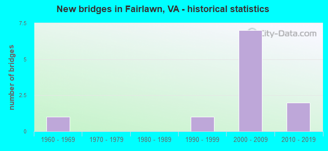
- New bridges - historical statistics
- 11960-1969
- 11990-1999
- 72000-2009
- 22010-2019


- Bridge Condition - Deck
- 50.0%Good
- 33.3%Satisfactory
- 16.7%Poor

- Bridge Condition - Superstructure
- 66.7%Good
- 33.3%Satisfactory

- Bridge Condition - Substructure
- 66.7%Good
- 16.7%Satisfactory
- 16.7%Fair

- Bridge Condition - Channel
- 50.0%Very good
- 16.7%Satisfactory
- 16.7%Fair
- 16.7%Poor
Find on map >> Show street view
Structure Number: 5341, Location: 0.2 Fr 726 & 0.05 To 10 (Lat: 37.333047, Lng: -77.326736), Route carried "on" structure: County highway 746, Year Built: 2003, Status: Open, Structure Length: 0.82m (2.69ft), Average Daily Traffic: 3,692 (year 2020), Truck Traffic: 2%, Average Future Daily Traffic: 4,061 (year 2040), Design Load: H 20, Features Intersected: JOHNSON CREEK, Facility Carried by Structure: ENON CHURCH ROAD
Minimum Vertical Clearance: 30+ m (98+ ft), Kilometerpoint: 9.525, Lanes on structure: 2, Owner: State Highway Agency, Approaching Roadway Width: 10.1m (33.1ft), Skew: 3 degrees, Material/Design: Steel, Design/Construction: Culvert, Number Of Spans In Main Unit: 3, Length of Maximum Span: 2.1m (6.9ft)
Condition: Channel: Poor, Culverts: Poor, Operating Rating: 44.5 metric tons, Method Used To Determine Operating Rating: Load Factor (LF), Inventory Rating: 32.7 metric tons, Method Used To Determine Inventory Rating: Load Factor (LF), Structural Evaluation: Meets minimum limits, Waterway Adequacy: Equal to present minimum criteria, Approach Roadway Alignment: Equal to present desirable criteria, Designated Inspection Frequency: Every 12 months, Inspection Date: January 2022
Find on map >> Show street view
Structure Number: 12165, Location: 0.00-PULASK; 0.00-MONTG C (Lat: 37.160700, Lng: -80.553803), Route carried "on" structure: State highway 114, Year Built: 1990, Status: Open, Structure Length: 31.61m (103.71ft), Average Daily Traffic: 13,808 (year 2020), Truck Traffic: 2%, Average Future Daily Traffic: 15,176 (year 2040), Design Load: HS 20+Mod, Features Intersected: NEW RIVER
Minimum Vertical Clearance: 30+ m (98+ ft), Kilometerpoint: 3.652, Lanes on structure: 2, Base Highway Network: Yes, Owner: State Highway Agency, Approaching Roadway Width: 9.8m (32.2ft), Material/Design: Steel, Design/Construction: Stringer/Multi-beam, Number Of Spans In Main Unit: 1, Number Of Approach Spans: 15, Length of Maximum Span: 36.6m (120.1ft), Curb-To-Curb Width: 13.1m (43.0ft), Out-to-Out Width: 14.0m (45.9ft)
Condition: Deck: Good, Superstructure: Good, Substructure: Satisfactory, Channel: Satisfactory, Operating Rating: 74.4 metric tons, Method Used To Determine Operating Rating: Load and Resistance Factor (LRFR), Inventory Rating: 57.2 metric tons, Method Used To Determine Inventory Rating: Load and Resistance Factor (LRFR), Structural Evaluation: Equal to present minimum criteria, Deck Geometry: Somewhat better than minimum adequacy, Waterway Adequacy: Equal to present desirable criteria, Approach Roadway Alignment: Equal to present desirable criteria, Designated Inspection Frequency: Every 24 months, Underwater Inspection Frequency: Every 60 months, Inspection Date: December 2020, Underwater Inspection Date: August 2017, Deck Structure Type: Concrete Precast Panels, Wearing Surface/Protective System: Wearing Surface: Epoxy Overlay, Deck Protection: Epoxy Coated Reinforcing
Find on map >> Show street view
Structure Number: 26579, Location: 0.0 PULASKI CL;0.0 RAD CL (Lat: 37.139953, Lng: -80.575650), Route carried "on" structure: US 11, Year Built: 2002, Status: Open, Structure Length: 45.57m (149.51ft), Average Daily Traffic: 11,431 (year 2020), Truck Traffic: 3%, Average Future Daily Traffic: 16,005 (year 2040), Design Load: HS 20+Mod, Features Intersected: NEW RIVER & NS RAILWAY
Minimum Vertical Clearance: 30+ m (98+ ft), Kilometerpoint: 173.804, Lanes on structure: 3, Lanes under structure: 4, Base Highway Network: Yes, Owner: State Highway Agency, Approaching Roadway Width: 16.5m (54.1ft), Material/Design: Steel continuous, Design/Construction: Stringer/Multi-beam, Number Of Spans In Main Unit: 7, Length of Maximum Span: 69.5m (228.0ft), Curb or Sidewalk Widths: Left: 0.0m, Right: 1.7m (5.6ft), Curb-To-Curb Width: 16.1m (52.8ft), Out-to-Out Width: 17.0m (55.8ft)
Condition: Deck: Satisfactory, Superstructure: Good, Substructure: Good, Channel: Very good, Operating Rating: 55.3 metric tons, Method Used To Determine Operating Rating: Load and Resistance Factor (LRFR), Inventory Rating: 42.6 metric tons, Method Used To Determine Inventory Rating: Load and Resistance Factor (LRFR), Structural Evaluation: Better than present minimum criteria, Deck Geometry: Better than present minimum criteria, Underclear: Superior to present desirable criteria, Waterway Adequacy: Superior to present desirable criteria, Approach Roadway Alignment: Equal to present desirable criteria, Designated Inspection Frequency: Every 24 months, Underwater Inspection Frequency: Every 60 months, Inspection Date: July 2020, Underwater Inspection Date: August 2017, Deck Structure Type: Concrete Cast-file-Place, Wearing Surface/Protective System: Deck Protection: Epoxy Coated Reinforcing
Find on map >> Show street view
Structure Number: 27932, Location: 0.0-PULASKI & 0.0-MONTG (Lat: 37.162403, Lng: -80.551014), Route carried "on" structure: State highway 114, Year Built: 2013, Status: Open, Structure Length: 31.67m (103.90ft), Average Daily Traffic: 6,904 (year 2020), Truck Traffic: 2%, Average Future Daily Traffic: 9,666 (year 2040), Design Load: HL 93, Features Intersected: NEW RIVER PEPPERS FERRY
Minimum Vertical Clearance: 30.18m (99.02ft), Kilometerpoint: 4.184, Lanes on structure: 2, Base Highway Network: Yes, Owner: State Highway Agency, Approaching Roadway Width: 12.8m (42.0ft), Material/Design: Steel continuous, Design/Construction: Stringer/Multi-beam, Number Of Spans In Main Unit: 9, Length of Maximum Span: 37.2m (122.0ft), Curb-To-Curb Width: 12.2m (40.0ft), Out-to-Out Width: 13.1m (43.0ft)
Condition: Deck: Good, Superstructure: Good, Substructure: Good, Channel: Very good, Operating Rating: 59.0 metric tons, Method Used To Determine Operating Rating: Load and Resistance Factor (LRFR), Inventory Rating: 45.4 metric tons, Method Used To Determine Inventory Rating: Load and Resistance Factor (LRFR), Structural Evaluation: Better than present minimum criteria, Deck Geometry: Better than present minimum criteria, Waterway Adequacy: Equal to present minimum criteria, Approach Roadway Alignment: Equal to present desirable criteria, Designated Inspection Frequency: Every 24 months, Inspection Date: December 2021, Deck Structure Type: Concrete Cast-file-Place, Wearing Surface/Protective System: Deck Protection: Other Coated Reinforcing
Find on map >> Show street view
Structure Number: 27933, Location: 7.21-RT. 460;0.21-PULAS C (Lat: 37.163611, Lng: -80.548806), Route carried "on" structure: State highway 114, Year Built: 2013, Status: Open, Structure Length: 4.51m (14.80ft), Average Daily Traffic: 6,692 (year 2020), Truck Traffic: 2%, Average Future Daily Traffic: 9,369 (year 2040), Design Load: HL 93, Features Intersected: NS RAILWAY
Minimum Vertical Clearance: 30+ m (98+ ft), Kilometerpoint: 4.162, Lanes on structure: 2, Base Highway Network: Yes, Owner: State Highway Agency, Approaching Roadway Width: 12.2m (40.0ft), Skew: 2 degrees, Material/Design: Prestressed concrete, Design/Construction: Stringer/Multi-beam, Number Of Spans In Main Unit: 2, Length of Maximum Span: 30.8m (101.0ft), Curb-To-Curb Width: 12.2m (40.0ft), Out-to-Out Width: 13.2m (43.3ft)
Condition: Deck: Good, Superstructure: Good, Substructure: Good, Operating Rating: 56.2 metric tons, Method Used To Determine Operating Rating: Load and Resistance Factor (LRFR), Inventory Rating: 33.6 metric tons, Method Used To Determine Inventory Rating: Load and Resistance Factor (LRFR), Structural Evaluation: Better than present minimum criteria, Deck Geometry: Better than present minimum criteria, Underclear: Superior to present desirable criteria, Approach Roadway Alignment: Equal to present desirable criteria, Designated Inspection Frequency: Every 24 months, Inspection Date: December 2021, Deck Structure Type: Concrete Cast-file-Place, Wearing Surface/Protective System: Deck Protection: Other Coated Reinforcing
Find on map >> Show street view
Structure Number: 28002, Location: 0.0 PULASKI CO;0.0 RAD CL (Lat: 37.139819, Lng: -80.575922), Route carried "on" structure: US 11, Year Built: 2005, Status: Open, Structure Length: 46.28m (151.84ft), Average Daily Traffic: 11,431 (year 2020), Truck Traffic: 3%, Average Future Daily Traffic: 16,005 (year 2040), Design Load: HS 20+Mod, Features Intersected: NEW RIVER & NS RAILWAY
Minimum Vertical Clearance: 30+ m (98+ ft), Kilometerpoint: 173.804, Lanes on structure: 3, Lanes under structure: 4, Base Highway Network: Yes, Owner: State Highway Agency, Approaching Roadway Width: 16.5m (54.1ft), Material/Design: Steel continuous, Design/Construction: Stringer/Multi-beam, Number Of Spans In Main Unit: 7, Length of Maximum Span: 69.5m (228.0ft), Curb or Sidewalk Widths: Left: 0.0m, Right: 1.7m (5.6ft), Curb-To-Curb Width: 16.1m (52.8ft), Out-to-Out Width: 17.0m (55.8ft)
Condition: Deck: Satisfactory, Superstructure: Satisfactory, Substructure: Good, Channel: Very good, Operating Rating: 56.2 metric tons, Method Used To Determine Operating Rating: Load and Resistance Factor (LRFR), Inventory Rating: 43.5 metric tons, Method Used To Determine Inventory Rating: Load and Resistance Factor (LRFR), Structural Evaluation: Equal to present minimum criteria, Deck Geometry: Better than present minimum criteria, Underclear: Superior to present desirable criteria, Waterway Adequacy: Superior to present desirable criteria, Approach Roadway Alignment: Equal to present desirable criteria, Designated Inspection Frequency: Every 24 months, Underwater Inspection Frequency: Every 60 months, Inspection Date: July 2020, Underwater Inspection Date: August 2017, Deck Structure Type: Concrete Cast-file-Place, Wearing Surface/Protective System: Deck Protection: Epoxy Coated Reinforcing
Find on map >> Show street view
Structure Number: DAPFORAPH000002, Location: 2/3 MI W JEFF DAVIS DR (Lat: 38.106750, Lng: -77.373261), Route carried "on" structure: Other road , Year Built: 1968, Year Reconstructed: 1998, Status: Open, Structure Length: 1.62m (5.31ft), Average Daily Traffic: 20 (year 2020), Truck Traffic: 40%, Average Future Daily Traffic: 20 (year 2042), Design Load: HS 20, Features Intersected: TURKEY TRACK CREEK, Facility Carried by Structure: THORNTON ROAD
Minimum Vertical Clearance: 30+ m (98+ ft), Kilometerpoint: 0.000, Lanes on structure: 1, Owner: Army, Approaching Roadway Width: 7.3m (24.0ft), Material/Design: Steel, Design/Construction: Stringer/Multi-beam, Number Of Spans In Main Unit: 1, Length of Maximum Span: 15.5m (50.9ft), Curb or Sidewalk Widths: Left: 0.2m (0.7ft), Right: 0.2m (0.7ft), Curb-To-Curb Width: 7.4m (24.3ft), Out-to-Out Width: 8.0m (26.2ft)
Condition: Deck: Poor, Superstructure: Satisfactory, Substructure: Fair, Channel: Fair, Operating Rating: 38.9 metric tons, Method Used To Determine Operating Rating: Load and Resistance Factor Rating (LRFR) rating reported by rating factor(RF) method using HL-93 loadings, Inventory Rating: 29.8 metric tons, Method Used To Determine Inventory Rating: Load and Resistance Factor Rating (LRFR) rating reported by rating factor(RF) method using HL-93 loadings, Structural Evaluation: Somewhat better than minimum adequacy, Deck Geometry: Equal to present minimum criteria, Waterway Adequacy: Equal to present minimum criteria, Approach Roadway Alignment: Equal to present minimum criteria, Length Of Structure Improvement: 2.31m (7.58ft), Designated Inspection Frequency: Every 24 months, Inspection Date: October 2020, Bridge Improvement Cost: $1,000, Roadway Improvement Cost: $1,000, Total Project Cost: $2,000 ( Estimate for 2020), Deck Structure Type: Wood or Timber, Wearing Surface/Protective System: Wearing Surface: Wood or Timber
Find on map >> Show street view
Structure Number: 26579, Location: 0.0 PULASKI CL;0.0 RAD CL (Lat: 37.139953, Lng: -80.575650), Route carried "under" structure: City street , Year Built: 2002, Structure Length: 0. m, Average Daily Traffic: 400 (year 1994), Features Intersected: NEW RIVER & NS RAILWAY, Facility Carried by Structure: RTE. 11 SBL
Minimum Vertical Clearance: 15.24m (50.00ft), Kilometerpoint: 0.000, Lanes on structure: 3, Lanes under structure: 2, Material/Design: Steel continuous, Design/Construction: Stringer/Multi-beam, Length of Maximum Span: 69.5m (228.0ft)
Find on map >> Show street view
Structure Number: 26579, Location: 0.0 PULASKI CL;0.0 RAD CL (Lat: 37.139953, Lng: -80.575650), Route carried "under" structure: Other road , Year Built: 2002, Structure Length: 0. m, Average Daily Traffic: 100 (year 1994), Features Intersected: NEW RIVER & NS RAILWAY, Facility Carried by Structure: RTE. 11 SBL
Minimum Vertical Clearance: 9.29m (30.48ft), Kilometerpoint: 0.000, Lanes on structure: 3, Lanes under structure: 2, Material/Design: Steel continuous, Design/Construction: Stringer/Multi-beam, Length of Maximum Span: 69.5m (228.0ft)
Find on map >> Show street view
Structure Number: 28002, Location: 0.0 PULASKI CO;0.0 RAD CL (Lat: 37.139819, Lng: -80.575922), Route carried "under" structure: Other road , Year Built: 2005, Structure Length: 0. m, Average Daily Traffic: 100 (year 1994), Features Intersected: NEW RIVER & NS RAILWAY, Facility Carried by Structure: RTE. 11 NBL
Minimum Vertical Clearance: 9.07m (29.76ft), Kilometerpoint: 0.000, Lanes on structure: 3, Lanes under structure: 2, Material/Design: Steel continuous, Design/Construction: Stringer/Multi-beam, Length of Maximum Span: 69.5m (228.0ft)
Find on map >> Show street view
Structure Number: 28002, Location: 0.0 PULASKI CO;0.0 RAD CL (Lat: 37.139819, Lng: -80.575922), Route carried "under" structure: City street , Year Built: 2005, Structure Length: 0. m, Average Daily Traffic: 400 (year 1994), Features Intersected: NEW RIVER & NS RAILWAY, Facility Carried by Structure: RTE. 11 NBL
Minimum Vertical Clearance: 15.24m (50.00ft), Kilometerpoint: 0.000, Lanes on structure: 3, Lanes under structure: 2, Material/Design: Steel continuous, Design/Construction: Stringer/Multi-beam, Length of Maximum Span: 69.5m (228.0ft)