Bridge Statistics for Falkville, Alabama (AL)
Condition, Traffic, Stress, Structural Evaluation, Project Costs
- National Bridge Inventory (NBI) Statistics
- 41Number of bridges
- 482ft / 147mTotal length
- $59,967,000Total costs
- 394,644Total average daily traffic
- 109,091Total average daily truck traffic
- National Bridge Inventory (NBI) Registered Bridges for Falkville
- No street view available for this location
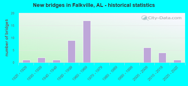
- New bridges - historical statistics
- 11920-1929
- 21930-1939
- 11940-1949
- 91950-1959
- 171960-1969
- 62000-2009
- 42010-2019
- 12020-2022
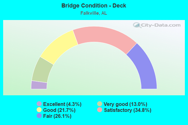
- Bridge Condition - Deck
- 4.3%Excellent
- 13.0%Very good
- 21.7%Good
- 34.8%Satisfactory
- 26.1%Fair
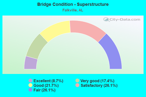
- Bridge Condition - Superstructure
- 8.7%Excellent
- 17.4%Very good
- 21.7%Good
- 26.1%Satisfactory
- 26.1%Fair
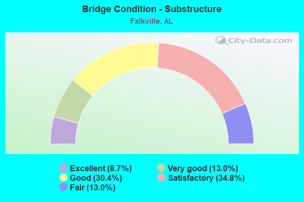
- Bridge Condition - Substructure
- 8.7%Excellent
- 13.0%Very good
- 30.4%Good
- 34.8%Satisfactory
- 13.0%Fair
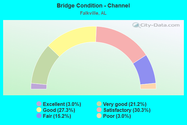
- Bridge Condition - Channel
- 3.0%Excellent
- 21.2%Very good
- 27.3%Good
- 30.3%Satisfactory
- 15.2%Fair
- 3.0%Poor
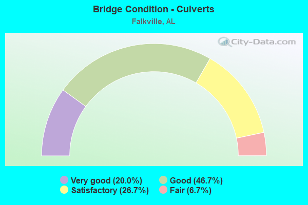
- Bridge Condition - Culverts
- 20.0%Very good
- 46.7%Good
- 26.7%Satisfactory
- 6.7%Fair
Find on map >> Show street view
Structure Number: 882, Location: 3.5 M S JCT SR 3 & SR 36 (Lat: 34.398531, Lng: -86.914217), Route carried "on" structure: US 31, Year Built: 1931, Status: Closed, Structure Length: 4.54m (14.90ft), Average Daily Traffic: 4,335 (year 2019), Truck Traffic: 6%, Average Future Daily Traffic: 5,568 (year 2033), Design Load: H 15, Features Intersected: CEDAR CREEK, Facility Carried by Structure: SR 3
Minimum Vertical Clearance: 30+ m (98+ ft), Kilometerpoint: 551.730, Lanes on structure: 2, Base Highway Network: Yes, Owner: State Highway Agency, Approaching Roadway Width: 9.1m (29.9ft), Skew: 10 degrees, Material/Design: Concrete, Design/Construction: Tee Beam, Number Of Spans In Main Unit: 5, Length of Maximum Span: 11.0m (36.1ft), Curb or Sidewalk Widths: Left: 0.1m (0.3ft), Right: 0.1m (0.3ft), Curb-To-Curb Width: 7.3m (24.0ft), Out-to-Out Width: 8.2m (26.9ft)
Condition: Deck: Satisfactory, Superstructure: Satisfactory, Substructure: Satisfactory, Channel: Satisfactory, Operating Rating: 45.4 metric tons, Method Used To Determine Operating Rating: Allowable Stress (AS), Inventory Rating: 21.8 metric tons, Method Used To Determine Inventory Rating: Allowable Stress (AS), Structural Evaluation: Somewhat better than minimum adequacy, Waterway Adequacy: Equal to present minimum criteria, Approach Roadway Alignment: Equal to present minimum criteria, Length Of Structure Improvement: 5.54m (18.18ft), Designated Inspection Frequency: Every 24 months, Inspection Date: May 2019, Bridge Improvement Cost: $987,000, Roadway Improvement Cost: $99,000, Total Project Cost: $1,086,000 ( Estimate for 2022), Deck Structure Type: Concrete Cast-file-Place
Find on map >> Show street view
Structure Number: 2011, Location: JACKSON TRACE RD. (Lat: 33.694383, Lng: -86.074656), Route carried "on" structure: County highway 47, Year Built: 1939, Status: Open, Structure Length: 1.65m (5.41ft), Average Daily Traffic: 110 (year 1993), Truck Traffic: 1%, Average Future Daily Traffic: 150 (year 2040), Features Intersected: ACKER CREEK, Facility Carried by Structure: JACKSON TRACE RD.
Minimum Vertical Clearance: 30+ m (98+ ft), Kilometerpoint: 0.010, Lanes on structure: 1, Owner: County Highway Agency, Approaching Roadway Width: 5.2m (17.1ft), Material/Design: Steel continuous, Design/Construction: Stringer/Multi-beam, Number Of Spans In Main Unit: 4, Length of Maximum Span: 6.1m (20.0ft), Curb-To-Curb Width: 3.8m (12.5ft), Out-to-Out Width: 4.1m (13.5ft)
Condition: Deck: Fair, Superstructure: Satisfactory, Substructure: Satisfactory, Channel: Fair, Operating Rating: 46.4 metric tons, Method Used To Determine Operating Rating: Allowable Stress (AS), Inventory Rating: 30.1 metric tons, Method Used To Determine Inventory Rating: Allowable Stress (AS), Structural Evaluation: Equal to present minimum criteria, Deck Geometry: High priority of replacement, Waterway Adequacy: Equal to present minimum criteria, Approach Roadway Alignment: Somewhat better than minimum adequacy, Length Of Structure Improvement: 2.34m (7.68ft), Designated Inspection Frequency: Every 24 months, Inspection Date: May 2020, Bridge Improvement Cost: $209,000, Roadway Improvement Cost: $21,000, Total Project Cost: $230,000 ( Estimate for 2022), Deck Structure Type: Concrete Cast-file-Place
Find on map >> Show street view
Structure Number: 2139, Location: 0.05 MI S JCT CR 53 (Lat: 34.878903, Lng: -85.981208), Route carried "on" structure: County highway , Year Built: 1940, Status: Posted for load, Structure Length: 3.17m (10.40ft), Average Daily Traffic: 44 (year 1989), Average Future Daily Traffic: 69 (year 2039), Design Load: H 10, Features Intersected: BIG COON CREEK, Facility Carried by Structure: CO RD 563
Minimum Vertical Clearance: 30+ m (98+ ft), Kilometerpoint: 0.010, Lanes on structure: 1, Owner: County Highway Agency, Approaching Roadway Width: 4.9m (16.1ft), Material/Design: Steel, Design/Construction: Stringer/Multi-beam, Number Of Spans In Main Unit: 5, Length of Maximum Span: 7.6m (24.9ft), Curb-To-Curb Width: 4.0m (13.1ft), Out-to-Out Width: 4.3m (14.1ft)
Condition: Deck: Fair, Superstructure: Fair, Substructure: Fair, Channel: Satisfactory, Operating Rating: 14.3 metric tons, Method Used To Determine Operating Rating: Load Factor (LF), Inventory Rating: 8.6 metric tons, Method Used To Determine Inventory Rating: Load Factor (LF), Structural Evaluation: High priority of replacement, Deck Geometry: Somewhat better than minimum adequacy, Waterway Adequacy: Better than present minimum criteria, Approach Roadway Alignment: Equal to present minimum criteria, Bridge Posting: Required (Relationship of Operating Rating to Maximum Legal Load: > 39.9% below), Length Of Structure Improvement: 4.03m (13.22ft), Designated Inspection Frequency: Every 24 months, Other Special Inspection Frequency: Every 12 months, Inspection Date: October 2021, Other Special Inspection Date: October 2021, Bridge Improvement Cost: $387,000, Roadway Improvement Cost: $39,000, Total Project Cost: $426,000 ( Estimate for 2022), Deck Structure Type: Corrugated Steel, Wearing Surface/Protective System: Wearing Surface: Bituminous
Find on map >> Show street view
Structure Number: 3768, Location: 0.5 MI W SR 31 (Lat: 34.332475, Lng: -86.909061), Route carried "on" structure: County highway 45, Year Built: 1950, Status: Open, Structure Length: 0.67m (2.20ft), Average Daily Traffic: 1,440 (year 2007), Truck Traffic: 10%, Average Future Daily Traffic: 2,824 (year 2041), Design Load: HS 15, Features Intersected: FLINT CREEK RELIEF, Facility Carried by Structure: OLD HWY 31
Minimum Vertical Clearance: 0.00m, Kilometerpoint: 0.010, Lanes on structure: 2, Owner: County Highway Agency, Approaching Roadway Width: 6.7m (22.0ft), Material/Design: Concrete, Design/Construction: Culvert, Number Of Spans In Main Unit: 2, Length of Maximum Span: 3.0m (9.8ft)
Condition: Channel: Fair, Culverts: Satisfactory, Operating Rating: 77.4 metric tons, Method Used To Determine Operating Rating: Load Factor (LF), Inventory Rating: 46.4 metric tons, Method Used To Determine Inventory Rating: Load Factor (LF), Structural Evaluation: Equal to present minimum criteria, Waterway Adequacy: Better than present minimum criteria, Approach Roadway Alignment: Equal to present minimum criteria, Length Of Structure Improvement: 1.30m (4.27ft), Designated Inspection Frequency: Every 24 months, Inspection Date: January 2021, Bridge Improvement Cost: $248,000, Roadway Improvement Cost: $25,000, Total Project Cost: $273,000 ( Estimate for 2022)
Find on map >> Show street view
Structure Number: 3784, Location: 1.2 N W US 31 (Lat: 34.363506, Lng: -86.927939), Route carried "on" structure: County highway 49, Year Built: 1950, Status: Posted for load, Structure Length: 1.46m (4.79ft), Average Daily Traffic: 80 (year 2007), Average Future Daily Traffic: 149 (year 2041), Design Load: H 10, Features Intersected: FLINT CREEK, Facility Carried by Structure: ROBINSON CRK RD
Minimum Vertical Clearance: 30+ m (98+ ft), Kilometerpoint: 0.010, Lanes on structure: 1, Owner: County Highway Agency, Approaching Roadway Width: 5.5m (18.0ft), Material/Design: Steel, Design/Construction: Stringer/Multi-beam, Number Of Spans In Main Unit: 1, Length of Maximum Span: 14.6m (47.9ft), Curb-To-Curb Width: 4.6m (15.1ft), Out-to-Out Width: 4.6m (15.1ft)
Condition: Deck: Fair, Superstructure: Fair, Substructure: Fair, Channel: Fair, Operating Rating: 14.5 metric tons, Method Used To Determine Operating Rating: Allowable Stress (AS), Inventory Rating: 4.5 metric tons, Method Used To Determine Inventory Rating: Allowable Stress (AS), Structural Evaluation: High priority of replacement, Deck Geometry: Better than present minimum criteria, Waterway Adequacy: High priority of corrective action, Approach Roadway Alignment: High priority of corrective action, Bridge Posting: Required (Relationship of Operating Rating to Maximum Legal Load: > 39.9% below), Length Of Structure Improvement: 2.14m (7.02ft), Designated Inspection Frequency: Every 24 months, Other Special Inspection Frequency: Every 12 months, Inspection Date: January 2021, Other Special Inspection Date: January 2022, Bridge Improvement Cost: $220,000, Roadway Improvement Cost: $22,000, Total Project Cost: $242,000 ( Estimate for 2022), Deck Structure Type: Concrete Cast-file-Place
Find on map >> Show street view
Structure Number: 4006, Location: 1 MI N JCT SR 3 & I 65 (Lat: 34.329056, Lng: -86.901114), Route carried "on" structure: US 31, Year Built: 1951, Status: Open, Structure Length: 7.25m (23.79ft), Average Daily Traffic: 5,290 (year 2021), Truck Traffic: 7%, Average Future Daily Traffic: 6,795 (year 2033), Design Load: HS 20, Features Intersected: FLINT CREEK, Facility Carried by Structure: SR 3
Minimum Vertical Clearance: 30+ m (98+ ft), Kilometerpoint: 543.870, Lanes on structure: 2, Base Highway Network: Yes, Owner: State Highway Agency, Approaching Roadway Width: 12.8m (42.0ft), Skew: 3 degrees, Material/Design: Steel, Design/Construction: Stringer/Multi-beam, Number Of Spans In Main Unit: 7, Length of Maximum Span: 10.4m (34.1ft), Curb or Sidewalk Widths: Left: 0.5m (1.6ft), Right: 0.5m (1.6ft), Curb-To-Curb Width: 8.5m (27.9ft), Out-to-Out Width: 10.2m (33.5ft)
Condition: Deck: Fair, Superstructure: Satisfactory, Substructure: Satisfactory, Channel: Satisfactory, Operating Rating: 47.1 metric tons, Method Used To Determine Operating Rating: Load Factor (LF), Inventory Rating: 28.2 metric tons, Method Used To Determine Inventory Rating: Load Factor (LF), Structural Evaluation: Equal to present minimum criteria, Deck Geometry: Meets minimum limits, Waterway Adequacy: Somewhat better than minimum adequacy, Approach Roadway Alignment: Equal to present minimum criteria, Length Of Structure Improvement: 8.28m (27.17ft), Designated Inspection Frequency: Every 24 months, Inspection Date: May 2021, Bridge Improvement Cost: $1,873,000, Roadway Improvement Cost: $187,000, Total Project Cost: $2,060,000 ( Estimate for 2022), Deck Structure Type: Concrete Cast-file-Place
Find on map >> Show street view
Structure Number: 4411, Location: 2.9 M S JCT SR 67 & SR 36 (Lat: 34.421667, Lng: -86.714833), Route carried "on" structure: State highway 67, Year Built: 1952, Status: Open, Structure Length: 4.15m (13.62ft), Average Daily Traffic: 4,500 (year 2021), Truck Traffic: 20%, Average Future Daily Traffic: 5,838 (year 2033), Design Load: H 15, Features Intersected: SIX MILE CREEK
Minimum Vertical Clearance: 7.56m (24.80ft), Kilometerpoint: 34.252, Lanes on structure: 2, Owner: State Highway Agency, Approaching Roadway Width: 7.9m (25.9ft), Skew: 4 degrees, Material/Design: Concrete, Design/Construction: Tee Beam, Number Of Spans In Main Unit: 4, Length of Maximum Span: 10.4m (34.1ft), Curb or Sidewalk Widths: Left: 0.5m (1.6ft), Right: 0.5m (1.6ft), Curb-To-Curb Width: 7.3m (24.0ft), Out-to-Out Width: 9.0m (29.5ft)
Condition: Deck: Satisfactory, Superstructure: Good, Substructure: Good, Channel: Satisfactory, Operating Rating: 33.1 metric tons, Method Used To Determine Operating Rating: Load Factor (LF), Inventory Rating: 19.9 metric tons, Method Used To Determine Inventory Rating: Load Factor (LF), Structural Evaluation: Somewhat better than minimum adequacy, Deck Geometry: High priority of replacement, Waterway Adequacy: Equal to present minimum criteria, Approach Roadway Alignment: Equal to present minimum criteria, Length Of Structure Improvement: 5.12m (16.80ft), Designated Inspection Frequency: Every 24 months, Inspection Date: October 2021, Bridge Improvement Cost: $1,018,000, Roadway Improvement Cost: $102,000, Total Project Cost: $1,120,000 ( Estimate for 2022), Deck Structure Type: Concrete Cast-file-Place, Wearing Surface/Protective System: Wearing Surface: Bituminous
Find on map >> Show street view
Structure Number: 4543, Location: 3 MI N JCT SR 3 & I 65 (Lat: 34.360000, Lng: -86.908333), Route carried "on" structure: US 31, Year Built: 1953, Status: Open, Structure Length: 0.64m (2.10ft), Average Daily Traffic: 5,290 (year 2021), Truck Traffic: 7%, Average Future Daily Traffic: 6,795 (year 2033), Design Load: H 15, Features Intersected: TOWN CREEK, Facility Carried by Structure: SR 3
Minimum Vertical Clearance: 30+ m (98+ ft), Kilometerpoint: 547.331, Lanes on structure: 4, Base Highway Network: Yes, Owner: State Highway Agency, Approaching Roadway Width: 25.6m (84.0ft), Skew: 20 degrees, Material/Design: Concrete continuous, Design/Construction: Culvert, Number Of Spans In Main Unit: 2, Length of Maximum Span: 3.0m (9.8ft)
Condition: Channel: Satisfactory, Culverts: Good, Operating Rating: 60.0 metric tons, Method Used To Determine Operating Rating: Load Factor (LF), Inventory Rating: 35.9 metric tons, Method Used To Determine Inventory Rating: Load Factor (LF), Structural Evaluation: Better than present minimum criteria, Waterway Adequacy: Equal to present minimum criteria, Approach Roadway Alignment: Equal to present desirable criteria, Length Of Structure Improvement: 1.26m (4.13ft), Designated Inspection Frequency: Every 24 months, Inspection Date: May 2021, Bridge Improvement Cost: $691,000, Roadway Improvement Cost: $69,000, Total Project Cost: $760,000 ( Estimate for 2022), Wearing Surface/Protective System: Wearing Surface: Bituminous
Find on map >> Show street view
Structure Number: 4544, Location: 4.1 M N JCT SR 3 & I 65 (Lat: 34.374569, Lng: -86.910911), Route carried "on" structure: US 31, Year Built: 1953, Status: Open, Structure Length: 1.34m (4.40ft), Average Daily Traffic: 7,390 (year 2021), Truck Traffic: 6%, Average Future Daily Traffic: 9,493 (year 2033), Design Load: H 15, Features Intersected: PAINTERS CREEK, Facility Carried by Structure: SR 3
Minimum Vertical Clearance: 30.20m (99.08ft), Kilometerpoint: 548.970, Lanes on structure: 4, Base Highway Network: Yes, Owner: State Highway Agency, Approaching Roadway Width: 15.2m (49.9ft), Skew: 24 degrees, Material/Design: Concrete continuous, Design/Construction: Culvert, Number Of Spans In Main Unit: 3, Length of Maximum Span: 3.0m (9.8ft)
Condition: Channel: Satisfactory, Culverts: Good, Operating Rating: 56.5 metric tons, Method Used To Determine Operating Rating: Load Factor (LF), Inventory Rating: 33.9 metric tons, Method Used To Determine Inventory Rating: Load Factor (LF), Structural Evaluation: Better than present minimum criteria, Waterway Adequacy: Equal to present minimum criteria, Approach Roadway Alignment: Equal to present desirable criteria, Length Of Structure Improvement: 2.02m (6.63ft), Designated Inspection Frequency: Every 24 months, Inspection Date: May 2021, Bridge Improvement Cost: $1,513,000, Roadway Improvement Cost: $151,000, Total Project Cost: $1,664,000 ( Estimate for 2022), Wearing Surface/Protective System: Wearing Surface: Bituminous
Find on map >> Show street view
Structure Number: 4545, Location: 3.5 M S JCT SR 3 & SR 36 (Lat: 34.398333, Lng: -86.913333), Route carried "on" structure: US 31, Year Built: 1953, Status: Open, Structure Length: 5.18m (16.99ft), Average Daily Traffic: 4,335 (year 2021), Truck Traffic: 6%, Average Future Daily Traffic: 5,568 (year 2033), Design Load: HS 20, Features Intersected: CEDAR CREEK, Facility Carried by Structure: SR 3
Minimum Vertical Clearance: 30+ m (98+ ft), Kilometerpoint: 551.730, Lanes on structure: 2, Base Highway Network: Yes, Owner: State Highway Agency, Approaching Roadway Width: 13.4m (44.0ft), Skew: 10 degrees, Material/Design: Concrete, Design/Construction: Tee Beam, Number Of Spans In Main Unit: 5, Length of Maximum Span: 10.4m (34.1ft), Curb or Sidewalk Widths: Left: 0.5m (1.6ft), Right: 0.5m (1.6ft), Curb-To-Curb Width: 8.5m (27.9ft), Out-to-Out Width: 10.2m (33.5ft)
Condition: Deck: Good, Superstructure: Good, Substructure: Good, Channel: Satisfactory, Operating Rating: 50.2 metric tons, Method Used To Determine Operating Rating: Load Factor (LF), Inventory Rating: 30.3 metric tons, Method Used To Determine Inventory Rating: Load Factor (LF), Structural Evaluation: Better than present minimum criteria, Deck Geometry: Meets minimum limits, Waterway Adequacy: Equal to present minimum criteria, Approach Roadway Alignment: Better than present minimum criteria, Length Of Structure Improvement: 6.20m (20.34ft), Designated Inspection Frequency: Every 24 months, Inspection Date: May 2021, Bridge Improvement Cost: $1,403,000, Roadway Improvement Cost: $140,000, Total Project Cost: $1,543,000 ( Estimate for 2022), Deck Structure Type: Concrete Cast-file-Place, Wearing Surface/Protective System: Wearing Surface: Bituminous
Find on map >> Show street view
Structure Number: 5481, Location: 1.5 MI W FR 31 (Lat: 34.373311, Lng: -86.933664), Route carried "on" structure: County highway 13, Year Built: 1956, Status: Posted for load, Structure Length: 7.25m (23.79ft), Average Daily Traffic: 2,065 (year 2003), Truck Traffic: 5%, Average Future Daily Traffic: 4,394 (year 2040), Design Load: H 15, Features Intersected: FLINT CREEK, Facility Carried by Structure: COUNTY HWY 55W
Minimum Vertical Clearance: 30+ m (98+ ft), Kilometerpoint: 0.010, Lanes on structure: 2, Owner: County Highway Agency, Approaching Roadway Width: 6.7m (22.0ft), Skew: 3 degrees, Material/Design: Concrete, Design/Construction: Tee Beam, Number Of Spans In Main Unit: 7, Length of Maximum Span: 10.4m (34.1ft), Curb-To-Curb Width: 6.7m (22.0ft), Out-to-Out Width: 7.6m (24.9ft)
Condition: Deck: Satisfactory, Superstructure: Satisfactory, Substructure: Satisfactory, Channel: Fair, Operating Rating: 36.3 metric tons, Method Used To Determine Operating Rating: Load Factor (LF), Inventory Rating: 21.8 metric tons, Method Used To Determine Inventory Rating: Load Factor (LF), Structural Evaluation: Somewhat better than minimum adequacy, Deck Geometry: High priority of replacement, Waterway Adequacy: Equal to present minimum criteria, Approach Roadway Alignment: Equal to present minimum criteria, Bridge Posting: Required (Relationship of Operating Rating to Maximum Legal Load: 10.0 - 19.9% below), Length Of Structure Improvement: 8.28m (27.17ft), Designated Inspection Frequency: Every 24 months, Other Special Inspection Frequency: Every 12 months, Inspection Date: July 2020, Other Special Inspection Date: July 2021, Bridge Improvement Cost: $1,362,000, Roadway Improvement Cost: $136,000, Total Project Cost: $1,498,000 ( Estimate for 2022), Deck Structure Type: Concrete Cast-file-Place
Find on map >> Show street view
Structure Number: 8192, Location: 1 MI N JCT I 65 & SR 3 (Lat: 34.328336, Lng: -86.900425), Route carried "on" structure: Interstate 65, Year Built: 1964, Status: Open, Structure Length: 11.03m (36.19ft), Average Daily Traffic: 15,465 (year 2020), Truck Traffic: 31%, Average Future Daily Traffic: 19,593 (year 2033), Design Load: HS 20, Features Intersected: FLINT CREEK
Minimum Vertical Clearance: 30+ m (98+ ft), Kilometerpoint: 513.363, Lanes on structure: 2, Base Highway Network: Yes, Owner: State Highway Agency, Approaching Roadway Width: 12.2m (40.0ft), Skew: 12 degrees, Material/Design: Concrete, Design/Construction: Tee Beam, Number Of Spans In Main Unit: 6, Length of Maximum Span: 18.6m (61.0ft), Curb or Sidewalk Widths: Left: 0.5m (1.6ft), Right: 0.5m (1.6ft), Curb-To-Curb Width: 8.5m (27.9ft), Out-to-Out Width: 10.1m (33.1ft)
Condition: Deck: Fair, Superstructure: Satisfactory, Substructure: Satisfactory, Channel: Satisfactory, Operating Rating: 50.3 metric tons, Method Used To Determine Operating Rating: Load Factor (LF), Inventory Rating: 30.1 metric tons, Method Used To Determine Inventory Rating: Load Factor (LF), Structural Evaluation: Equal to present minimum criteria, Deck Geometry: High priority of corrective action, Waterway Adequacy: Equal to present minimum criteria, Approach Roadway Alignment: Better than present minimum criteria, Length Of Structure Improvement: 11.92m (39.11ft), Designated Inspection Frequency: Every 24 months, Underwater Inspection Frequency: Every 24 months, Inspection Date: December 2020, Underwater Inspection Date: June 2020, Bridge Improvement Cost: $2,698,000, Roadway Improvement Cost: $270,000, Total Project Cost: $2,968,000 ( Estimate for 2022), Deck Structure Type: Concrete Cast-file-Place, Wearing Surface/Protective System: Membrane: Epoxy, Deck Protection: Other
Find on map >> Show street view
Structure Number: 8193, Location: 1 MI N JCT I 65 & SR 3 (Lat: 34.328206, Lng: -86.900194), Route carried "on" structure: Interstate 65, Year Built: 1964, Status: Open, Structure Length: 11.03m (36.19ft), Average Daily Traffic: 15,465 (year 2020), Truck Traffic: 31%, Average Future Daily Traffic: 19,593 (year 2033), Design Load: HS 20, Features Intersected: FLINT CREEK
Minimum Vertical Clearance: 30+ m (98+ ft), Kilometerpoint: 513.363, Lanes on structure: 2, Base Highway Network: Yes, Owner: State Highway Agency, Approaching Roadway Width: 12.2m (40.0ft), Skew: 12 degrees, Material/Design: Concrete, Design/Construction: Tee Beam, Number Of Spans In Main Unit: 6, Length of Maximum Span: 18.6m (61.0ft), Curb or Sidewalk Widths: Left: 0.5m (1.6ft), Right: 0.5m (1.6ft), Curb-To-Curb Width: 8.5m (27.9ft), Out-to-Out Width: 10.1m (33.1ft)
Condition: Deck: Satisfactory, Superstructure: Fair, Substructure: Satisfactory, Channel: Satisfactory, Operating Rating: 50.3 metric tons, Method Used To Determine Operating Rating: Load Factor (LF), Inventory Rating: 30.1 metric tons, Method Used To Determine Inventory Rating: Load Factor (LF), Structural Evaluation: Somewhat better than minimum adequacy, Deck Geometry: High priority of corrective action, Waterway Adequacy: Equal to present minimum criteria, Approach Roadway Alignment: Equal to present minimum criteria, Length Of Structure Improvement: 11.92m (39.11ft), Designated Inspection Frequency: Every 24 months, Underwater Inspection Frequency: Every 24 months, Inspection Date: December 2020, Underwater Inspection Date: June 2020, Bridge Improvement Cost: $2,698,000, Roadway Improvement Cost: $270,000, Total Project Cost: $2,968,000 ( Estimate for 2022), Deck Structure Type: Concrete Cast-file-Place, Wearing Surface/Protective System: Membrane: Epoxy, Deck Protection: Other
Find on map >> Show street view
Structure Number: 8194, Location: 1 MI N JCT I 65 & SR 3 (Lat: 34.330322, Lng: -86.899728), Route carried "on" structure: Interstate 65, Year Built: 1964, Status: Open, Structure Length: 7.32m (24.02ft), Average Daily Traffic: 15,465 (year 2020), Truck Traffic: 31%, Average Future Daily Traffic: 19,593 (year 2033), Design Load: HS 20, Features Intersected: CSX RAILROAD
Minimum Vertical Clearance: 30+ m (98+ ft), Kilometerpoint: 513.606, Lanes on structure: 2, Base Highway Network: Yes, Owner: State Highway Agency, Approaching Roadway Width: 12.2m (40.0ft), Skew: 15 degrees, Material/Design: Steel, Design/Construction: Stringer/Multi-beam, Number Of Spans In Main Unit: 3, Length of Maximum Span: 24.4m (80.1ft), Curb or Sidewalk Widths: Left: 0.5m (1.6ft), Right: 0.5m (1.6ft), Curb-To-Curb Width: 8.5m (27.9ft), Out-to-Out Width: 10.1m (33.1ft)
Condition: Deck: Satisfactory, Superstructure: Fair, Substructure: Satisfactory, Operating Rating: 52.9 metric tons, Method Used To Determine Operating Rating: Allowable Stress (AS), Inventory Rating: 29.2 metric tons, Method Used To Determine Inventory Rating: Allowable Stress (AS), Structural Evaluation: Somewhat better than minimum adequacy, Deck Geometry: High priority of corrective action, Underclear: Equal to present minimum criteria, Approach Roadway Alignment: Equal to present minimum criteria, Length Of Structure Improvement: 8.35m (27.40ft), Designated Inspection Frequency: Every 24 months, Inspection Date: December 2020, Bridge Improvement Cost: $1,889,000, Roadway Improvement Cost: $189,000, Total Project Cost: $2,078,000 ( Estimate for 2022), Deck Structure Type: Concrete Cast-file-Place, Wearing Surface/Protective System: Membrane: Epoxy, Deck Protection: Other
Find on map >> Show street view
Structure Number: 8195, Location: 1 MI N JCT I 65 & SR 3 (Lat: 34.330083, Lng: -86.899542), Route carried "on" structure: Interstate 65, Year Built: 1964, Status: Open, Structure Length: 7.32m (24.02ft), Average Daily Traffic: 15,465 (year 2020), Truck Traffic: 31%, Average Future Daily Traffic: 19,593 (year 2033), Design Load: HS 20, Features Intersected: CSX RAILROAD
Minimum Vertical Clearance: 30+ m (98+ ft), Kilometerpoint: 513.604, Lanes on structure: 2, Base Highway Network: Yes, Owner: State Highway Agency, Approaching Roadway Width: 12.2m (40.0ft), Skew: 15 degrees, Material/Design: Steel, Design/Construction: Stringer/Multi-beam, Number Of Spans In Main Unit: 3, Length of Maximum Span: 24.4m (80.1ft), Curb or Sidewalk Widths: Left: 0.5m (1.6ft), Right: 0.5m (1.6ft), Curb-To-Curb Width: 8.5m (27.9ft), Out-to-Out Width: 10.1m (33.1ft)
Condition: Deck: Satisfactory, Superstructure: Fair, Substructure: Satisfactory, Operating Rating: 52.9 metric tons, Method Used To Determine Operating Rating: Allowable Stress (AS), Inventory Rating: 29.2 metric tons, Method Used To Determine Inventory Rating: Allowable Stress (AS), Structural Evaluation: Somewhat better than minimum adequacy, Deck Geometry: High priority of corrective action, Underclear: Equal to present minimum criteria, Approach Roadway Alignment: Equal to present minimum criteria, Length Of Structure Improvement: 8.35m (27.40ft), Designated Inspection Frequency: Every 24 months, Inspection Date: December 2020, Bridge Improvement Cost: $1,889,000, Roadway Improvement Cost: $189,000, Total Project Cost: $2,078,000 ( Estimate for 2022), Deck Structure Type: Concrete Cast-file-Place, Wearing Surface/Protective System: Membrane: Epoxy, Deck Protection: Other
Find on map >> Show street view
Structure Number: 8196, Location: 2 MI N JCT I 65 & SR 3 (Lat: 34.339042, Lng: -86.894594), Route carried "on" structure: Interstate 65, Year Built: 1964, Status: Open, Structure Length: 1.10m (3.61ft), Average Daily Traffic: 30,930 (year 2021), Truck Traffic: 31%, Average Future Daily Traffic: 39,186 (year 2033), Design Load: H 20, Features Intersected: BRANCH
Minimum Vertical Clearance: 30+ m (98+ ft), Kilometerpoint: 514.725, Lanes on structure: 4, Base Highway Network: Yes, Owner: State Highway Agency, Approaching Roadway Width: 14.6m (47.9ft), Skew: 14 degrees, Material/Design: Concrete, Design/Construction: Culvert, Number Of Spans In Main Unit: 2, Length of Maximum Span: 2.4m (7.9ft)
Condition: Channel: Good, Culverts: Satisfactory, Operating Rating: 50.9 metric tons, Method Used To Determine Operating Rating: Load Factor (LF), Inventory Rating: 30.5 metric tons, Method Used To Determine Inventory Rating: Load Factor (LF), Structural Evaluation: Equal to present minimum criteria, Waterway Adequacy: Better than present minimum criteria, Approach Roadway Alignment: Equal to present desirable criteria, Length Of Structure Improvement: 1.77m (5.81ft), Designated Inspection Frequency: Every 24 months, Inspection Date: December 2021, Bridge Improvement Cost: $2,920,000, Roadway Improvement Cost: $292,000, Total Project Cost: $3,212,000 ( Estimate for 2022)
Find on map >> Show street view
Structure Number: 9529, Location: 3 MI N JCT I 65 & SR 3 (Lat: 34.353525, Lng: -86.891375), Route carried "on" structure: County highway 200, Year Built: 1968, Status: Open, Structure Length: 9.39m (30.81ft), Average Daily Traffic: 218 (year 2020), Truck Traffic: 1%, Average Future Daily Traffic: 461 (year 2036), Design Load: H 20, Features Intersected: I 65, Facility Carried by Structure: PINEY GROVE RD
Minimum Vertical Clearance: 30+ m (98+ ft), Kilometerpoint: 0.000, Lanes on structure: 2, Lanes under structure: 4, Owner: State Highway Agency, Approaching Roadway Width: 7.3m (24.0ft), Material/Design: Steel, Design/Construction: Stringer/Multi-beam, Number Of Spans In Main Unit: 5, Length of Maximum Span: 18.9m (62.0ft), Curb or Sidewalk Widths: Left: 0.5m (1.6ft), Right: 0.5m (1.6ft), Curb-To-Curb Width: 7.3m (24.0ft), Out-to-Out Width: 8.9m (29.2ft)
Condition: Deck: Good, Superstructure: Good, Substructure: Good, Operating Rating: 59.0 metric tons, Method Used To Determine Operating Rating: Load Factor (LF), Inventory Rating: 35.3 metric tons, Method Used To Determine Inventory Rating: Load Factor (LF), Structural Evaluation: Better than present minimum criteria, Deck Geometry: Somewhat better than minimum adequacy, Underclear: Meets minimum limits, Approach Roadway Alignment: Somewhat better than minimum adequacy, Length Of Structure Improvement: 10.34m (33.92ft), Designated Inspection Frequency: Every 24 months, Inspection Date: April 2020, Bridge Improvement Cost: $2,057,000, Roadway Improvement Cost: $206,000, Total Project Cost: $2,263,000 ( Estimate for 2022), Deck Structure Type: Concrete Cast-file-Place
Find on map >> Show street view
Structure Number: 953, Location: 3 MI N JCT I 65 & SR 3 (Lat: 34.355056, Lng: -86.891533), Route carried "on" structure: Interstate 65, Year Built: 1968, Status: Open, Structure Length: 1.58m (5.18ft), Average Daily Traffic: 30,930 (year 2021), Truck Traffic: 31%, Average Future Daily Traffic: 39,186 (year 2033), Design Load: H 20, Features Intersected: ROBINSON CREEK
Minimum Vertical Clearance: 30+ m (98+ ft), Kilometerpoint: 516.791, Lanes on structure: 4, Base Highway Network: Yes, Owner: State Highway Agency, Approaching Roadway Width: 20.7m (67.9ft), Skew: 10 degrees, Material/Design: Concrete, Design/Construction: Culvert, Number Of Spans In Main Unit: 5, Length of Maximum Span: 3.0m (9.8ft)
Condition: Channel: Satisfactory, Culverts: Satisfactory, Operating Rating: 70.5 metric tons, Method Used To Determine Operating Rating: Load Factor (LF), Inventory Rating: 42.2 metric tons, Method Used To Determine Inventory Rating: Load Factor (LF), Structural Evaluation: Equal to present minimum criteria, Waterway Adequacy: Equal to present minimum criteria, Approach Roadway Alignment: Equal to present desirable criteria, Length Of Structure Improvement: 2.27m (7.45ft), Designated Inspection Frequency: Every 24 months, Inspection Date: December 2021, Bridge Improvement Cost: $2,582,000, Roadway Improvement Cost: $258,000, Total Project Cost: $2,840,000 ( Estimate for 2022)
Find on map >> Show street view
Structure Number: 9531, Location: 3.2 MI N JCT I 65 & SR 3 (Lat: 34.360000, Lng: -86.891667), Route carried "on" structure: Interstate 65, Year Built: 1968, Status: Open, Structure Length: 0.76m (2.49ft), Average Daily Traffic: 30,930 (year 2021), Truck Traffic: 31%, Average Future Daily Traffic: 39,186 (year 2033), Design Load: HS 20, Features Intersected: BRANCH
Minimum Vertical Clearance: 30+ m (98+ ft), Kilometerpoint: 517.016, Lanes on structure: 4, Base Highway Network: Yes, Owner: State Highway Agency, Approaching Roadway Width: 20.7m (67.9ft), Skew: 10 degrees, Material/Design: Concrete continuous, Design/Construction: Culvert, Number Of Spans In Main Unit: 3, Length of Maximum Span: 2.4m (7.9ft)
Condition: Channel: Fair, Culverts: Good, Operating Rating: 44.2 metric tons, Method Used To Determine Operating Rating: Load Factor (LF), Inventory Rating: 26.5 metric tons, Method Used To Determine Inventory Rating: Load Factor (LF), Structural Evaluation: Equal to present minimum criteria, Waterway Adequacy: Equal to present minimum criteria, Approach Roadway Alignment: Equal to present desirable criteria, Length Of Structure Improvement: 1.41m (4.63ft), Designated Inspection Frequency: Every 24 months, Inspection Date: December 2021, Bridge Improvement Cost: $1,601,000, Roadway Improvement Cost: $160,000, Total Project Cost: $1,761,000 ( Estimate for 2022)
Find on map >> Show street view
Structure Number: 9532, Location: 4 MI JCT I 65 & SR 3 (Lat: 34.368239, Lng: -86.891900), Route carried "on" structure: County highway 55, Year Built: 1968, Status: Open, Structure Length: 9.39m (30.81ft), Average Daily Traffic: 1,979 (year 2020), Truck Traffic: 4%, Average Future Daily Traffic: 3,800 (year 2035), Design Load: HS 20, Features Intersected: I 65, Facility Carried by Structure: E. PIKE RD
Minimum Vertical Clearance: 30+ m (98+ ft), Kilometerpoint: 0.000, Lanes on structure: 2, Lanes under structure: 4, Owner: State Highway Agency, Approaching Roadway Width: 6.1m (20.0ft), Material/Design: Steel, Design/Construction: Stringer/Multi-beam, Number Of Spans In Main Unit: 5, Length of Maximum Span: 18.9m (62.0ft), Curb or Sidewalk Widths: Left: 0.5m (1.6ft), Right: 0.5m (1.6ft), Curb-To-Curb Width: 8.5m (27.9ft), Out-to-Out Width: 10.1m (33.1ft)
Condition: Deck: Satisfactory, Superstructure: Good, Substructure: Good, Operating Rating: 59.7 metric tons, Method Used To Determine Operating Rating: Load Factor (LF), Inventory Rating: 35.7 metric tons, Method Used To Determine Inventory Rating: Load Factor (LF), Structural Evaluation: Better than present minimum criteria, Deck Geometry: Somewhat better than minimum adequacy, Underclear: Meets minimum limits, Approach Roadway Alignment: Equal to present minimum criteria, Length Of Structure Improvement: 10.34m (33.92ft), Designated Inspection Frequency: Every 24 months, Inspection Date: April 2020, Bridge Improvement Cost: $2,340,000, Roadway Improvement Cost: $234,000, Total Project Cost: $2,574,000 ( Estimate for 2022), Deck Structure Type: Concrete Cast-file-Place
Find on map >> Show street view
Structure Number: 9533, Location: 4 MI N JCT I 65 & SR 3 (Lat: 34.370200, Lng: -86.892300), Route carried "on" structure: Ramp Interstate 65, Year Built: 1968, Status: Open, Structure Length: 0.64m (2.10ft), Average Daily Traffic: 3,322 (year 2019), Truck Traffic: 30%, Average Future Daily Traffic: 4,208 (year 2033), Design Load: H 20, Features Intersected: BRANCH
Minimum Vertical Clearance: 30+ m (98+ ft), Kilometerpoint: 518.225, Lanes on structure: 1, Base Highway Network: Yes, Owner: State Highway Agency, Approaching Roadway Width: 7.9m (25.9ft), Skew: 1 degrees, Material/Design: Concrete, Design/Construction: Culvert, Number Of Spans In Main Unit: 2, Length of Maximum Span: 3.0m (9.8ft)
Condition: Channel: Good, Culverts: Good, Operating Rating: 88.9 metric tons, Method Used To Determine Operating Rating: Load Factor (LF), Inventory Rating: 88.9 metric tons, Method Used To Determine Inventory Rating: Load Factor (LF), Structural Evaluation: Better than present minimum criteria, Waterway Adequacy: Equal to present desirable criteria, Approach Roadway Alignment: Equal to present desirable criteria, Length Of Structure Improvement: 1.26m (4.13ft), Designated Inspection Frequency: Every 24 months, Inspection Date: December 2021, Bridge Improvement Cost: $691,000, Roadway Improvement Cost: $69,000, Total Project Cost: $760,000 ( Estimate for 2022), Wearing Surface/Protective System: Wearing Surface: Bituminous
Find on map >> Show street view
Structure Number: 9534, Location: 4 MI N JCT I 65 & SR 3 (Lat: 34.370200, Lng: -86.891500), Route carried "on" structure: Interstate 65, Year Built: 1968, Status: Open, Structure Length: 0.64m (2.10ft), Average Daily Traffic: 33,220 (year 2021), Truck Traffic: 30%, Average Future Daily Traffic: 42,087 (year 2033), Design Load: H 20, Features Intersected: BRANCH
Minimum Vertical Clearance: 30+ m (98+ ft), Kilometerpoint: 518.225, Lanes on structure: 4, Base Highway Network: Yes, Owner: State Highway Agency, Approaching Roadway Width: 12.2m (40.0ft), Skew: 10 degrees, Material/Design: Concrete continuous, Design/Construction: Culvert, Number Of Spans In Main Unit: 2, Length of Maximum Span: 3.0m (9.8ft)
Condition: Channel: Very good, Culverts: Satisfactory, Operating Rating: 88.9 metric tons, Method Used To Determine Operating Rating: Load Factor (LF), Inventory Rating: 88.9 metric tons, Method Used To Determine Inventory Rating: Load Factor (LF), Structural Evaluation: Equal to present minimum criteria, Waterway Adequacy: Equal to present desirable criteria, Approach Roadway Alignment: Equal to present desirable criteria, Length Of Structure Improvement: 1.26m (4.13ft), Designated Inspection Frequency: Every 24 months, Inspection Date: December 2021, Bridge Improvement Cost: $1,616,000, Roadway Improvement Cost: $162,000, Total Project Cost: $1,778,000 ( Estimate for 2022), Wearing Surface/Protective System: Wearing Surface: Bituminous
Find on map >> Show street view
Structure Number: 9535, Location: 4 MI N JCT I 65 & SR 3 (Lat: 34.370200, Lng: -86.890700), Route carried "on" structure: Ramp Interstate 65, Year Built: 1968, Status: Open, Structure Length: 0.64m (2.10ft), Average Daily Traffic: 3,322 (year 2021), Truck Traffic: 30%, Average Future Daily Traffic: 4,208 (year 2033), Design Load: H 20, Features Intersected: BRANCH
Minimum Vertical Clearance: 7.56m (24.80ft), Kilometerpoint: 518.225, Lanes on structure: 1, Base Highway Network: Yes, Owner: State Highway Agency, Approaching Roadway Width: 7.9m (25.9ft), Skew: 2 degrees, Material/Design: Concrete continuous, Design/Construction: Culvert, Number Of Spans In Main Unit: 2, Length of Maximum Span: 3.0m (9.8ft)
Condition: Channel: Good, Culverts: Good, Operating Rating: 88.9 metric tons, Method Used To Determine Operating Rating: Load Factor (LF), Inventory Rating: 88.9 metric tons, Method Used To Determine Inventory Rating: Load Factor (LF), Structural Evaluation: Better than present minimum criteria, Waterway Adequacy: Equal to present desirable criteria, Approach Roadway Alignment: Equal to present desirable criteria, Length Of Structure Improvement: 1.26m (4.13ft), Designated Inspection Frequency: Every 24 months, Inspection Date: December 2021, Bridge Improvement Cost: $728,000, Roadway Improvement Cost: $73,000, Total Project Cost: $801,000 ( Estimate for 2022), Wearing Surface/Protective System: Wearing Surface: Bituminous
Find on map >> Show street view
Structure Number: 14686, Location: 0.5 MI W FR 31 (Lat: 34.333867, Lng: -86.908681), Route carried "on" structure: County highway 45, Year Built: 1922, Year Reconstructed: 1989, Status: Open, Structure Length: 5.68m (18.64ft), Average Daily Traffic: 1,440 (year 2007), Truck Traffic: 5%, Average Future Daily Traffic: 2,766 (year 2040), Design Load: H 15, Features Intersected: FLINT CREEK, Facility Carried by Structure: OLD HWY 31
Minimum Vertical Clearance: 30+ m (98+ ft), Kilometerpoint: 0.010, Lanes on structure: 2, Owner: County Highway Agency, Approaching Roadway Width: 8.2m (26.9ft), Material/Design: Concrete, Design/Construction: Tee Beam, Number Of Spans In Main Unit: 7, Length of Maximum Span: 8.2m (26.9ft), Curb-To-Curb Width: 8.3m (27.2ft), Out-to-Out Width: 9.1m (29.9ft)
Condition: Deck: Fair, Superstructure: Fair, Substructure: Fair, Channel: Poor, Operating Rating: 51.6 metric tons, Method Used To Determine Operating Rating: Load Factor (LF), Inventory Rating: 30.8 metric tons, Method Used To Determine Inventory Rating: Load Factor (LF), Structural Evaluation: Somewhat better than minimum adequacy, Deck Geometry: Meets minimum limits, Waterway Adequacy: Somewhat better than minimum adequacy, Approach Roadway Alignment: Equal to present minimum criteria, Length Of Structure Improvement: 6.72m (22.05ft), Designated Inspection Frequency: Every 24 months, Inspection Date: July 2020, Bridge Improvement Cost: $1,337,000, Roadway Improvement Cost: $134,000, Total Project Cost: $1,471,000 ( Estimate for 2022), Deck Structure Type: Concrete Cast-file-Place, Wearing Surface/Protective System: Wearing Surface: Bituminous
Find on map >> Show street view
Structure Number: 18511, Location: 1.0 MI EAST SR 31 (Lat: 34.338644, Lng: -86.885744), Route carried "on" structure: County highway 1045, Year Built: 2003, Status: Open, Structure Length: 1.30m (4.27ft), Average Daily Traffic: 791 (year 2003), Truck Traffic: 5%, Average Future Daily Traffic: 1,676 (year 2041), Design Load: HS 20, Features Intersected: BRANCH OF FLINT CREEK
Minimum Vertical Clearance: 9.14m (29.99ft), Kilometerpoint: 0.000, Lanes on structure: 2, Owner: County Highway Agency, Approaching Roadway Width: 10.4m (34.1ft), Skew: 3 degrees, Material/Design: Concrete, Design/Construction: Culvert, Number Of Spans In Main Unit: 3, Length of Maximum Span: 4.2m (13.8ft)
Condition: Channel: Very good, Culverts: Very good, Operating Rating: 57.2 metric tons, Method Used To Determine Operating Rating: Load Factor (LF), Inventory Rating: 33.6 metric tons, Method Used To Determine Inventory Rating: Load Factor (LF), Structural Evaluation: Equal to present desirable criteria, Waterway Adequacy: Equal to present desirable criteria, Approach Roadway Alignment: Equal to present desirable criteria, Length Of Structure Improvement: 1.98m (6.50ft), Designated Inspection Frequency: Every 24 months, Inspection Date: July 2021, Bridge Improvement Cost: $479,000, Roadway Improvement Cost: $48,000, Total Project Cost: $527,000 ( Estimate for 2022)
Find on map >> Show street view
Structure Number: 19914, Location: 0.9 MI W SISPEY RIVER (Lat: 33.276889, Lng: -87.769256), Route carried "on" structure: US 82, Year Built: 2010, Status: Open, Structure Length: 7.76m (25.46ft), Average Daily Traffic: 6,070 (year 2013), Truck Traffic: 16%, Average Future Daily Traffic: 7,859 (year 2033), Design Load: HS 20, Features Intersected: SIPSEY RIVER RELIEF
Minimum Vertical Clearance: 30+ m (98+ ft), Kilometerpoint: 55.497, Lanes on structure: 2, Base Highway Network: Yes, Owner: State Highway Agency, Approaching Roadway Width: 11.0m (36.1ft), Skew: 3 degrees, Material/Design: Prestressed concrete, Design/Construction: Stringer/Multi-beam, Number Of Spans In Main Unit: 3, Length of Maximum Span: 25.8m (84.6ft), Curb-To-Curb Width: 12.3m (40.4ft), Out-to-Out Width: 13.0m (42.7ft)
Condition: Deck: Very good, Superstructure: Excellent, Substructure: Excellent, Channel: Good, Operating Rating: 88.9 metric tons, Method Used To Determine Operating Rating: Load Factor (LF), Inventory Rating: 38.6 metric tons, Method Used To Determine Inventory Rating: Load Factor (LF), Structural Evaluation: Superior to present desirable criteria, Deck Geometry: Better than present minimum criteria, Waterway Adequacy: Equal to present minimum criteria, Approach Roadway Alignment: Superior to present desirable criteria, Length Of Structure Improvement: 8.78m (28.81ft), Designated Inspection Frequency: Every 24 months, Inspection Date: November 2020, Bridge Improvement Cost: $2,528,000, Roadway Improvement Cost: $253,000, Total Project Cost: $2,781,000 ( Estimate for 2022), Deck Structure Type: Concrete Cast-file-Place
Find on map >> Show street view
Structure Number: 19916, Location: 0.4 MI W SIPSEY RIVER (Lat: 33.275025, Lng: -87.761361), Route carried "on" structure: US 82, Year Built: 2010, Status: Open, Structure Length: 6.24m (20.47ft), Average Daily Traffic: 6,070 (year 2016), Truck Traffic: 16%, Average Future Daily Traffic: 7,859 (year 2040), Design Load: HS 20, Features Intersected: SIPSEY RIVER RELIEF #3
Minimum Vertical Clearance: 30.18m (99.02ft), Kilometerpoint: 56.251, Lanes on structure: 2, Base Highway Network: Yes, Owner: State Highway Agency, Approaching Roadway Width: 11.5m (37.7ft), Skew: 3 degrees, Material/Design: Prestressed concrete, Design/Construction: Stringer/Multi-beam, Number Of Spans In Main Unit: 5, Length of Maximum Span: 12.5m (41.0ft), Curb-To-Curb Width: 12.2m (40.0ft), Out-to-Out Width: 13.0m (42.7ft)
Condition: Deck: Good, Superstructure: Very good, Substructure: Good, Channel: Good, Operating Rating: 64.0 metric tons, Method Used To Determine Operating Rating: Load Factor (LF), Inventory Rating: 37.6 metric tons, Method Used To Determine Inventory Rating: Load Factor (LF), Structural Evaluation: Better than present minimum criteria, Deck Geometry: Better than present minimum criteria, Waterway Adequacy: Equal to present minimum criteria, Approach Roadway Alignment: Superior to present desirable criteria, Length Of Structure Improvement: 7.28m (23.88ft), Designated Inspection Frequency: Every 24 months, Inspection Date: November 2020, Bridge Improvement Cost: $2,097,000, Roadway Improvement Cost: $210,000, Total Project Cost: $2,307,000 ( Estimate for 2022), Deck Structure Type: Concrete Cast-file-Place
Find on map >> Show street view
Structure Number: 19921, Location: .5 MI W EXIT 79 (Lat: 33.582794, Lng: -85.935033), Route carried "on" structure: Interstate 20, Year Built: 2008, Status: Open, Structure Length: 7.41m (24.31ft), Average Daily Traffic: 38,792 (year 2020), Truck Traffic: 38%, Average Future Daily Traffic: 54,309 (year 2040), Design Load: HS 20, Features Intersected: CO. LINE ROAD WEST
Minimum Vertical Clearance: 30+ m (98+ ft), Kilometerpoint: 288.351, Lanes on structure: 6, Lanes under structure: 2, Base Highway Network: Yes, Owner: State Highway Agency, Approaching Roadway Width: 18.2m (59.7ft), Skew: 30 degrees, Material/Design: Prestressed concrete, Design/Construction: Stringer/Multi-beam, Number Of Spans In Main Unit: 4, Length of Maximum Span: 20.4m (66.9ft), Curb-To-Curb Width: 36.6m (120.1ft), Out-to-Out Width: 38.0m (124.7ft)
Condition: Deck: Good, Superstructure: Good, Substructure: Very good, Operating Rating: 68.9 metric tons, Method Used To Determine Operating Rating: Load Factor (LF), Inventory Rating: 37.7 metric tons, Method Used To Determine Inventory Rating: Load Factor (LF), Structural Evaluation: Better than present minimum criteria, Deck Geometry: Superior to present desirable criteria, Underclear: Superior to present desirable criteria, Approach Roadway Alignment: Equal to present desirable criteria, Length Of Structure Improvement: 8.43m (27.66ft), Designated Inspection Frequency: Every 24 months, Inspection Date: September 2021, Bridge Improvement Cost: $7,168,000, Roadway Improvement Cost: $717,000, Total Project Cost: $7,885,000 ( Estimate for 2022), Deck Structure Type: Concrete Cast-file-Place
Find on map >> Show street view
Structure Number: 19924, Location: C.R. 94 (Lat: 31.405039, Lng: -87.148317), Route carried "on" structure: County highway , Year Built: 2004, Status: Posted for load, Structure Length: 2.55m (8.37ft), Average Daily Traffic: 60 (year 2007), Average Future Daily Traffic: 78 (year 2033), Features Intersected: BURNT CORN CREEK, Facility Carried by Structure: COUNTY ROAD
Minimum Vertical Clearance: 30+ m (98+ ft), Kilometerpoint: 0.000, Lanes on structure: 1, Owner: County Highway Agency, Approaching Roadway Width: 5.5m (18.0ft), Material/Design: Steel, Design/Construction: Stringer/Multi-beam, Number Of Spans In Main Unit: 3, Length of Maximum Span: 14.1m (46.3ft), Curb-To-Curb Width: 4.5m (14.8ft), Out-to-Out Width: 4.9m (16.1ft)
Condition: Deck: Satisfactory, Superstructure: Satisfactory, Substructure: Good, Channel: Good, Operating Rating: 14.3 metric tons, Method Used To Determine Operating Rating: Allowable Stress (AS), Inventory Rating: 10.7 metric tons, Method Used To Determine Inventory Rating: Allowable Stress (AS), Structural Evaluation: High priority of replacement, Deck Geometry: Equal to present minimum criteria, Waterway Adequacy: Equal to present minimum criteria, Approach Roadway Alignment: Somewhat better than minimum adequacy, Bridge Posting: Required (Relationship of Operating Rating to Maximum Legal Load: > 39.9% below), Length Of Structure Improvement: 3.45m (11.32ft), Designated Inspection Frequency: Every 24 months, Other Special Inspection Frequency: Every 12 months, Inspection Date: November 2021, Other Special Inspection Date: November 2021, Bridge Improvement Cost: $378,000, Roadway Improvement Cost: $38,000, Total Project Cost: $416,000 ( Estimate for 2022), Deck Structure Type: Wood or Timber, Wearing Surface/Protective System: Wearing Surface: Wood or Timber
Find on map >> Show street view
Structure Number: 19927, Location: .4 MI SOUTH OF CO. ROAD 2 (Lat: 33.233614, Lng: -87.684828), Route carried "on" structure: County highway 375, Year Built: 2006, Status: Open, Structure Length: 2.07m (6.79ft), Average Daily Traffic: 15 (year 2019), Average Future Daily Traffic: 20 (year 2029), Design Load: HS 20, Features Intersected: JAYS CREEK, Facility Carried by Structure: JAYS CREEK LANE
Minimum Vertical Clearance: 30+ m (98+ ft), Kilometerpoint: 0.000, Lanes on structure: 2, Owner: County Highway Agency, Approaching Roadway Width: 8.5m (27.9ft), Material/Design: Concrete, Design/Construction: Channel Beam, Number Of Spans In Main Unit: 2, Length of Maximum Span: 10.4m (34.1ft), Curb-To-Curb Width: 8.5m (27.9ft), Out-to-Out Width: 9.3m (30.5ft)
Condition: Deck: Very good, Superstructure: Very good, Substructure: Very good, Channel: Very good, Operating Rating: 74.1 metric tons, Method Used To Determine Operating Rating: Load Factor (LF), Inventory Rating: 44.5 metric tons, Method Used To Determine Inventory Rating: Load Factor (LF), Structural Evaluation: Equal to present desirable criteria, Deck Geometry: Better than present minimum criteria, Waterway Adequacy: Equal to present desirable criteria, Approach Roadway Alignment: Somewhat better than minimum adequacy, Length Of Structure Improvement: 2.84m (9.32ft), Designated Inspection Frequency: Every 24 months, Inspection Date: January 2021, Bridge Improvement Cost: $584,000, Roadway Improvement Cost: $58,000, Total Project Cost: $642,000 ( Estimate for 2022), Deck Structure Type: Concrete Precast Panels
Find on map >> Show street view
Structure Number: 20104, Location: .5 MILE NORTH GOV. DRIVE (Lat: 34.716678, Lng: -86.600028), Route carried "on" structure: City street , Year Built: 2009, Status: Open, Structure Length: 2.59m (8.50ft), Average Daily Traffic: 5,740 (year 2019), Truck Traffic: 3%, Average Future Daily Traffic: 8,036 (year 2039), Design Load: HS 20, Features Intersected: BROGLAN BRANCH, Facility Carried by Structure: WEST CLINTON AVE
Minimum Vertical Clearance: 30+ m (98+ ft), Kilometerpoint: 8.047, Lanes on structure: 4, Owner: City or Municipal Highway Agency, Approaching Roadway Width: 12.8m (42.0ft), Skew: 1 degrees, Material/Design: Prestressed concrete, Design/Construction: Stringer/Multi-beam, Number Of Spans In Main Unit: 2, Length of Maximum Span: 13.0m (42.7ft), Curb or Sidewalk Widths: Left: 1.8m (5.9ft), Right: 1.8m (5.9ft), Curb-To-Curb Width: 17.1m (56.1ft), Out-to-Out Width: 21.3m (69.9ft)
Condition: Deck: Good, Superstructure: Very good, Substructure: Good, Channel: Excellent, Operating Rating: 78.8 metric tons, Method Used To Determine Operating Rating: Load Factor (LF), Inventory Rating: 47.3 metric tons, Method Used To Determine Inventory Rating: Load Factor (LF), Structural Evaluation: Better than present minimum criteria, Deck Geometry: Somewhat better than minimum adequacy, Waterway Adequacy: Equal to present desirable criteria, Approach Roadway Alignment: Equal to present desirable criteria, Length Of Structure Improvement: 3.49m (11.45ft), Designated Inspection Frequency: Every 24 months, Inspection Date: June 2021, Bridge Improvement Cost: $1,676,000, Roadway Improvement Cost: $168,000, Total Project Cost: $1,844,000 ( Estimate for 2022), Deck Structure Type: Concrete Cast-file-Place
Find on map >> Show street view
Structure Number: 20206, Location: .13 FROM AL 27 (Lat: 31.373317, Lng: -85.834600), Route carried "on" structure: City street , Year Built: 2008, Status: Open, Structure Length: 1.22m (4.00ft), Average Daily Traffic: 30 (year 2019), Average Future Daily Traffic: 35 (year 2039), Design Load: HS 20, Features Intersected: STREAM, Facility Carried by Structure: LEGENDS TRAIL
Minimum Vertical Clearance: 30+ m (98+ ft), Kilometerpoint: 0.216, Lanes on structure: 2, Owner: City or Municipal Highway Agency, Approaching Roadway Width: 8.7m (28.5ft), Material/Design: Concrete, Design/Construction: Channel Beam, Number Of Spans In Main Unit: 1, Length of Maximum Span: 11.1m (36.4ft), Curb-To-Curb Width: 10.7m (35.1ft), Out-to-Out Width: 11.6m (38.1ft)
Condition: Deck: Excellent, Superstructure: Excellent, Substructure: Excellent, Channel: Very good, Operating Rating: 88.9 metric tons, Method Used To Determine Operating Rating: Load Factor (LF), Inventory Rating: 53.6 metric tons, Method Used To Determine Inventory Rating: Load Factor (LF), Structural Evaluation: Superior to present desirable criteria, Deck Geometry: Superior to present desirable criteria, Waterway Adequacy: Equal to present minimum criteria, Approach Roadway Alignment: Equal to present minimum criteria, Length Of Structure Improvement: 1.89m (6.20ft), Designated Inspection Frequency: Every 24 months, Inspection Date: Febuary 2021, Bridge Improvement Cost: $480,000, Roadway Improvement Cost: $48,000, Total Project Cost: $528,000 ( Estimate for 2022), Deck Structure Type: Concrete Precast Panels
Find on map >> Show street view
Structure Number: 20331, Location: 5.5 MI SW OF BERRY (Lat: 33.611322, Lng: -87.677069), Route carried "on" structure: County highway 15, Year Built: 1965, Status: Open, Structure Length: 0.64m (2.10ft), Average Daily Traffic: 108 (year 2010), Truck Traffic: 9%, Average Future Daily Traffic: 114 (year 2031), Design Load: HS 20, Features Intersected: SANDY PAINT CREEK
Minimum Vertical Clearance: 30+ m (98+ ft), Kilometerpoint: 3.541, Lanes on structure: 2, Owner: County Highway Agency, Approaching Roadway Width: 7.0m (23.0ft), Material/Design: Steel, Design/Construction: Culvert, Number Of Spans In Main Unit: 2, Length of Maximum Span: 2.9m (9.5ft)
Condition: Channel: Good, Culverts: Fair, Operating Rating: 88.9 metric tons, Method Used To Determine Operating Rating: Load Factor (LF), Inventory Rating: 88.9 metric tons, Method Used To Determine Inventory Rating: Load Factor (LF), Structural Evaluation: Somewhat better than minimum adequacy, Waterway Adequacy: Better than present minimum criteria, Approach Roadway Alignment: Better than present minimum criteria, Length Of Structure Improvement: 1.26m (4.13ft), Designated Inspection Frequency: Every 24 months, Inspection Date: December 2021, Bridge Improvement Cost: $298,000, Roadway Improvement Cost: $30,000, Total Project Cost: $328,000 ( Estimate for 2022)
Find on map >> Show street view
Structure Number: 20332, Location: 4.5 MI. NE OF FAYETTE (Lat: 33.705317, Lng: -87.753778), Route carried "on" structure: County highway 81, Year Built: 1967, Status: Open, Structure Length: 0.66m (2.17ft), Average Daily Traffic: 75 (year 2009), Average Future Daily Traffic: 100 (year 2030), Design Load: HS 20, Features Intersected: FULTON CREEK
Minimum Vertical Clearance: 30+ m (98+ ft), Kilometerpoint: 1.287, Lanes on structure: 2, Owner: County Highway Agency, Approaching Roadway Width: 7.3m (24.0ft), Material/Design: Concrete, Design/Construction: Culvert, Number Of Spans In Main Unit: 2, Length of Maximum Span: 3.0m (9.8ft), Curb or Sidewalk Widths: Left: 0.3m (1.0ft), Right: 0.3m (1.0ft)
Condition: Channel: Good, Culverts: Good, Operating Rating: 51.3 metric tons, Method Used To Determine Operating Rating: Load Factor (LF), Inventory Rating: 30.8 metric tons, Method Used To Determine Inventory Rating: Load Factor (LF), Structural Evaluation: Better than present minimum criteria, Waterway Adequacy: Better than present minimum criteria, Approach Roadway Alignment: Better than present minimum criteria, Length Of Structure Improvement: 1.28m (4.20ft), Designated Inspection Frequency: Every 24 months, Inspection Date: December 2021, Bridge Improvement Cost: $265,000, Roadway Improvement Cost: $27,000, Total Project Cost: $292,000 ( Estimate for 2022)
Find on map >> Show street view
Structure Number: 20333, Location: 3 MI SE OF GLENN ALLEN (Lat: 33.886089, Lng: -87.698769), Route carried "on" structure: County highway 53, Year Built: 1956, Status: Open, Structure Length: 0.67m (2.20ft), Average Daily Traffic: 173 (year 2009), Truck Traffic: 5%, Average Future Daily Traffic: 180 (year 2030), Design Load: HS 20, Features Intersected: TUCKER BRANCH
Minimum Vertical Clearance: 30+ m (98+ ft), Kilometerpoint: 16.576, Lanes on structure: 2, Owner: County Highway Agency, Approaching Roadway Width: 7.9m (25.9ft), Material/Design: Concrete, Design/Construction: Culvert, Number Of Spans In Main Unit: 2, Length of Maximum Span: 3.0m (9.8ft), Curb or Sidewalk Widths: Left: 0.3m (1.0ft), Right: 0.3m (1.0ft)
Condition: Channel: Good, Culverts: Good, Operating Rating: 88.9 metric tons, Method Used To Determine Operating Rating: Load Factor (LF), Inventory Rating: 88.9 metric tons, Method Used To Determine Inventory Rating: Load Factor (LF), Structural Evaluation: Better than present minimum criteria, Waterway Adequacy: Better than present minimum criteria, Approach Roadway Alignment: Better than present minimum criteria, Length Of Structure Improvement: 1.29m (4.23ft), Designated Inspection Frequency: Every 24 months, Inspection Date: December 2021, Bridge Improvement Cost: $336,000, Roadway Improvement Cost: $34,000, Total Project Cost: $370,000 ( Estimate for 2022)
Find on map >> Show street view
Structure Number: 20508, Location: 0.5MI EAST CR40 (Lat: 34.370014, Lng: -86.959964), Route carried "on" structure: County highway 1013, Year Built: 2011, Status: Open, Structure Length: 1.76m (5.77ft), Average Daily Traffic: 1,330 (year 2011), Truck Traffic: 10%, Average Future Daily Traffic: 2,460 (year 2042), Design Load: HS 20, Features Intersected: MACK CREEK, Facility Carried by Structure: HIGHWAY 55 WEST
Minimum Vertical Clearance: 30+ m (98+ ft), Kilometerpoint: 0.000, Lanes on structure: 2, Owner: County Highway Agency, Approaching Roadway Width: 9.8m (32.2ft), Material/Design: Concrete, Design/Construction: Culvert, Number Of Spans In Main Unit: 4, Length of Maximum Span: 4.3m (14.1ft), Curb or Sidewalk Widths: Left: 0.2m (0.7ft), Right: 0.2m (0.7ft), Curb-To-Curb Width: 12.4m (40.7ft), Out-to-Out Width: 12.9m (42.3ft)
Condition: Channel: Very good, Culverts: Very good, Operating Rating: 56.5 metric tons, Method Used To Determine Operating Rating: Load Factor (LF), Inventory Rating: 33.9 metric tons, Method Used To Determine Inventory Rating: Load Factor (LF), Structural Evaluation: Equal to present desirable criteria, Deck Geometry: Better than present minimum criteria, Waterway Adequacy: Equal to present minimum criteria, Approach Roadway Alignment: Equal to present desirable criteria, Length Of Structure Improvement: 2.46m (8.07ft), Designated Inspection Frequency: Every 24 months, Inspection Date: January 2022, Bridge Improvement Cost: $597,000, Roadway Improvement Cost: $60,000, Total Project Cost: $657,000 ( Estimate for 2022), Deck Structure Type: Concrete Cast-file-Place, Wearing Surface/Protective System: Wearing Surface: Bituminous
Find on map >> Show street view
Structure Number: 20636, Location: 0.7 MI WEST OF US31 (Lat: 34.330697, Lng: -86.914281), Route carried "on" structure: County highway 1047, Year Built: 2013, Status: Open, Structure Length: 1.77m (5.81ft), Average Daily Traffic: 440 (year 2012), Truck Traffic: 4%, Average Future Daily Traffic: 776 (year 2041), Design Load: HS 20, Features Intersected: SALLY MIKE CREEK, Facility Carried by Structure: WEST LACON ROAD
Minimum Vertical Clearance: 30+ m (98+ ft), Kilometerpoint: 0.000, Lanes on structure: 2, Owner: County Highway Agency, Approaching Roadway Width: 9.1m (29.9ft), Material/Design: Concrete, Design/Construction: Culvert, Number Of Spans In Main Unit: 4, Length of Maximum Span: 4.3m (14.1ft)
Condition: Channel: Very good, Culverts: Very good, Operating Rating: 39.7 metric tons, Method Used To Determine Operating Rating: Load Factor (LF), Inventory Rating: 23.9 metric tons, Method Used To Determine Inventory Rating: Load Factor (LF), Structural Evaluation: Equal to present minimum criteria, Waterway Adequacy: Equal to present desirable criteria, Approach Roadway Alignment: Equal to present desirable criteria, Length Of Structure Improvement: 2.47m (8.10ft), Designated Inspection Frequency: Every 24 months, Inspection Date: July 2021, Bridge Improvement Cost: $614,000, Roadway Improvement Cost: $61,000, Total Project Cost: $675,000 ( Estimate for 2022)
Find on map >> Show street view
Structure Number: 2139, Location: 3.5 MI S JCT SR 3 & SR 36 (Lat: 34.398492, Lng: -86.914206), Route carried "on" structure: US 31, Year Built: 2021, Status: Open, Structure Length: 6.10m (20.01ft), Average Daily Traffic: 9,130 (year 2021), Truck Traffic: 4%, Average Future Daily Traffic: 14,960 (year 2040), Design Load: HL 93, Features Intersected: CEDAR CREEK, Facility Carried by Structure: SR 3
Minimum Vertical Clearance: 30+ m (98+ ft), Kilometerpoint: 551.730, Lanes on structure: 2, Base Highway Network: Yes, Owner: State Highway Agency, Approaching Roadway Width: 12.2m (40.0ft), Skew: 10 degrees, Material/Design: Concrete, Design/Construction: Stringer/Multi-beam, Number Of Spans In Main Unit: 1, Number Of Approach Spans: 2, Length of Maximum Span: 24.4m (80.1ft), Curb-To-Curb Width: 12.2m (40.0ft), Out-to-Out Width: 12.9m (42.3ft)
Condition: Deck: Very good, Superstructure: Very good, Substructure: Very good, Channel: Very good, Operating Rating: 69.9 metric tons, Method Used To Determine Operating Rating: Load and Resistance Factor (LRFR), Inventory Rating: 53.1 metric tons, Method Used To Determine Inventory Rating: Load and Resistance Factor (LRFR), Structural Evaluation: Equal to present desirable criteria, Deck Geometry: Better than present minimum criteria, Waterway Adequacy: Equal to present desirable criteria, Approach Roadway Alignment: Equal to present desirable criteria, Length Of Structure Improvement: 7.14m (23.43ft), Designated Inspection Frequency: Every 24 months, Inspection Date: November 2021, Bridge Improvement Cost: $2,055,000, Roadway Improvement Cost: $206,000, Total Project Cost: $2,261,000 ( Estimate for 2022), Deck Structure Type: Concrete Cast-file-Place, Wearing Surface/Protective System: Wearing Surface: Monolithic Concrete
Find on map >> Show street view
Structure Number: 8197, Location: 2 MI N JCT I 65 & SR 3 (Lat: 34.339014, Lng: -86.893589), Route carried "under" structure: Interstate 65, Year Built: 1964, Structure Length: 0. m, Average Daily Traffic: 30,930 (year 2020), Truck Traffic: 31%, Features Intersected: I 65, Facility Carried by Structure: LACON ROAD
Minimum Vertical Clearance: 5.64m (18.50ft), Kilometerpoint: 514.741, Lanes on structure: 2, Lanes under structure: 4, Material/Design: Concrete continuous, Design/Construction: Tee Beam, Length of Maximum Span: 23.8m (78.1ft)
Find on map >> Show street view
Structure Number: 9529, Location: 3 MI N JCT I 65 & SR 3 (Lat: 34.353525, Lng: -86.891375), Route carried "under" structure: Interstate 65, Year Built: 1968, Structure Length: 0. m, Average Daily Traffic: 30,930 (year 2020), Truck Traffic: 31%, Features Intersected: I 65, Facility Carried by Structure: PINEY GROVE RD
Minimum Vertical Clearance: 5.23m (17.16ft), Kilometerpoint: 516.389, Lanes on structure: 2, Lanes under structure: 4, Material/Design: Steel, Design/Construction: Stringer/Multi-beam, Length of Maximum Span: 18.9m (62.0ft)
Find on map >> Show street view
Structure Number: 9532, Location: 4 MI JCT I 65 & SR 3 (Lat: 34.368239, Lng: -86.891900), Route carried "under" structure: Interstate 65, Year Built: 1968, Structure Length: 0. m, Average Daily Traffic: 30,930 (year 2020), Truck Traffic: 31%, Features Intersected: I 65, Facility Carried by Structure: E. PIKE RD
Minimum Vertical Clearance: 5.09m (16.70ft), Kilometerpoint: 517.998, Lanes on structure: 2, Lanes under structure: 4, Material/Design: Steel, Design/Construction: Stringer/Multi-beam, Length of Maximum Span: 18.9m (62.0ft)