Bridge Statistics for Farmington, Utah (UT)
Condition, Traffic, Stress, Structural Evaluation, Project Costs
- National Bridge Inventory (NBI) Statistics
- 49Number of bridges
- 984ft / 300mTotal length
- 1,801,214Total average daily traffic
- 357,492Total average daily truck traffic
- National Bridge Inventory (NBI) Registered Bridges for Farmington
- No street view available for this location
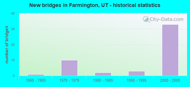
- New bridges - historical statistics
- 11960-1969
- 101970-1979
- 21980-1989
- 31990-1999
- 332000-2009
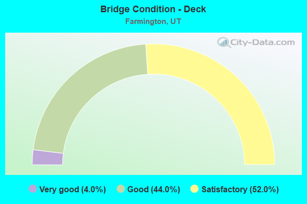
- Bridge Condition - Deck
- 4.0%Very good
- 44.0%Good
- 52.0%Satisfactory
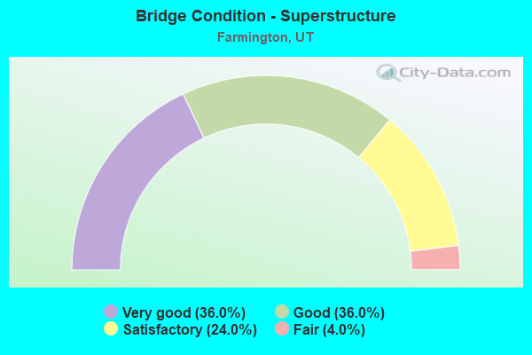
- Bridge Condition - Superstructure
- 36.0%Very good
- 36.0%Good
- 24.0%Satisfactory
- 4.0%Fair
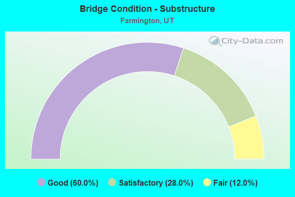
- Bridge Condition - Substructure
- 60.0%Good
- 28.0%Satisfactory
- 12.0%Fair
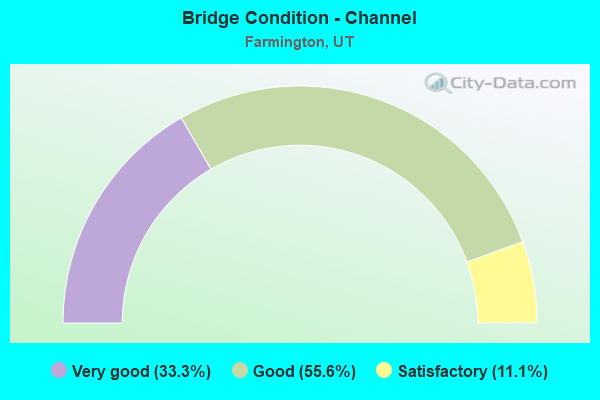
- Bridge Condition - Channel
- 33.3%Very good
- 55.6%Good
- 11.1%Satisfactory
Find on map >> Show street view
Structure Number: 11013E, Location: 650 W.CLARK LN.FARMINGTON (Lat: 40.980658, Lng: -111.902228), Route carried "on" structure: County highway 1454, Year Built: 1990, Status: Open, Structure Length: 1.37m (4.49ft), Average Daily Traffic: 10,712 (year 2020), Average Future Daily Traffic: 13,390 (year 2040), Design Load: HS 20+Mod, Features Intersected: FARMINGTON CREEK, Facility Carried by Structure: CLARK LANE, CO.RD.
Minimum Vertical Clearance: 30+ m (98+ ft), Kilometerpoint: 0.823, Lanes on structure: 2, Owner: County Highway Agency, Approaching Roadway Width: 19.5m (64.0ft), Skew: 23 degrees, Material/Design: Concrete continuous, Design/Construction: Culvert, Number Of Spans In Main Unit: 3, Length of Maximum Span: 6.7m (22.0ft), Curb or Sidewalk Widths: Left: 1.5m (4.9ft), Right: 3.4m (11.2ft)
Condition: Channel: Good, Culverts: Satisfactory, Operating Rating: 32.4 metric tons, Method Used To Determine Operating Rating: Load and Resistance Factor Rating (LRFR) rating reported by rating factor(RF) method using HL-93 loadings, Inventory Rating: 15.2 metric tons, Method Used To Determine Inventory Rating: Load and Resistance Factor Rating (LRFR) rating reported by rating factor(RF) method using HL-93 loadings, Structural Evaluation: High priority of corrective action, Waterway Adequacy: Equal to present desirable criteria, Approach Roadway Alignment: Equal to present desirable criteria, Designated Inspection Frequency: Every 23 months, Inspection Date: April 2020, Wearing Surface/Protective System: Wearing Surface: Bituminous
Find on map >> Show street view
Structure Number: 11021D, Location: 1000 W. 500 S.,FARMINGTON (Lat: 40.972189, Lng: -111.910878), Route carried "on" structure: City street , Year Built: 1993, Status: Open, Structure Length: 0.84m (2.76ft), Average Daily Traffic: 252 (year 2020), Truck Traffic: 1%, Average Future Daily Traffic: 306 (year 2040), Design Load: HS 20+Mod, Features Intersected: FARMINGTON CREEK, Facility Carried by Structure: 500 SOUTH STREET
Minimum Vertical Clearance: 30+ m (98+ ft), Kilometerpoint: 0.043, Lanes on structure: 2, Owner: City or Municipal Highway Agency, Approaching Roadway Width: 10.4m (34.1ft), Skew: 5 degrees, Material/Design: Concrete, Design/Construction: Frame, Number Of Spans In Main Unit: 1, Length of Maximum Span: 7.8m (25.6ft), Curb-To-Curb Width: 10.4m (34.1ft), Out-to-Out Width: 20.9m (68.6ft)
Condition: Deck: Satisfactory, Superstructure: Satisfactory, Substructure: Satisfactory, Channel: Good, Operating Rating: 34.0 metric tons, Method Used To Determine Operating Rating: Load and Resistance Factor Rating (LRFR) rating reported by rating factor(RF) method using HL-93 loadings, Inventory Rating: 28.5 metric tons, Method Used To Determine Inventory Rating: Load and Resistance Factor Rating (LRFR) rating reported by rating factor(RF) method using HL-93 loadings, Structural Evaluation: Equal to present minimum criteria, Deck Geometry: Better than present minimum criteria, Waterway Adequacy: Better than present minimum criteria, Approach Roadway Alignment: Equal to present minimum criteria, Designated Inspection Frequency: Every 24 months, Inspection Date: March 2020, Deck Structure Type: Concrete Cast-file-Place, Wearing Surface/Protective System: Wearing Surface: Bituminous
Find on map >> Show street view
Structure Number: 11026D, Location: 1350 W. GLOVER LN (Lat: 40.965278, Lng: -111.917261), Route carried "on" structure: County highway 1459, Year Built: 2005, Status: Open, Structure Length: 0.78m (2.56ft), Average Daily Traffic: 459 (year 2020), Average Future Daily Traffic: 574 (year 2040), Design Load: HS 20+Mod, Features Intersected: FARMINGTON CREEK, Facility Carried by Structure: GLOVER LANE
Minimum Vertical Clearance: 30+ m (98+ ft), Kilometerpoint: 2.853, Lanes on structure: 2, Owner: County Highway Agency, Approaching Roadway Width: 6.7m (22.0ft), Skew: 2 degrees, Material/Design: Concrete, Design/Construction: Slab, Number Of Spans In Main Unit: 1, Length of Maximum Span: 7.3m (24.0ft), Curb-To-Curb Width: 6.7m (22.0ft), Out-to-Out Width: 32.2m (105.6ft)
Condition: Deck: Satisfactory, Superstructure: Satisfactory, Substructure: Good, Channel: Satisfactory, Operating Rating: 32.4 metric tons, Method Used To Determine Operating Rating: Load and Resistance Factor Rating (LRFR) rating reported by rating factor(RF) method using HL-93 loadings, Inventory Rating: 19.8 metric tons, Method Used To Determine Inventory Rating: Load and Resistance Factor Rating (LRFR) rating reported by rating factor(RF) method using HL-93 loadings, Structural Evaluation: Somewhat better than minimum adequacy, Deck Geometry: Meets minimum limits, Waterway Adequacy: Better than present minimum criteria, Approach Roadway Alignment: Equal to present desirable criteria, Designated Inspection Frequency: Every 24 months, Inspection Date: March 2020, Deck Structure Type: Concrete Cast-file-Place, Wearing Surface/Protective System: Wearing Surface: Bituminous, Membrane: Preformed Fabric
Find on map >> Show street view
Structure Number: C 448, Location: 200 W.GLOVERS LN.FARMINGT (Lat: 40.965172, Lng: -111.892422), Route carried "on" structure: City street 1459, Year Built: 1973, Status: Open, Structure Length: 12.31m (40.39ft), Average Daily Traffic: 459 (year 2020), Average Future Daily Traffic: 574 (year 2040), Design Load: HS 20+Mod, Features Intersected: I-15 (SR-15), UPRR &, Facility Carried by Structure: GLOVER'S LANE
Minimum Vertical Clearance: 30+ m (98+ ft), Kilometerpoint: 0.763, Lanes on structure: 2, Lanes under structure: 9, Owner: State Highway Agency, Approaching Roadway Width: 9.4m (30.8ft), Material/Design: Steel continuous, Design/Construction: Stringer/Multi-beam, Number Of Spans In Main Unit: 3, Length of Maximum Span: 42.7m (140.1ft), Curb-To-Curb Width: 9.4m (30.8ft), Out-to-Out Width: 10.4m (34.1ft)
Condition: Deck: Satisfactory, Superstructure: Good, Substructure: Fair, Operating Rating: 55.1 metric tons, Method Used To Determine Operating Rating: Load and Resistance Factor Rating (LRFR) rating reported by rating factor(RF) method using HL-93 loadings, Inventory Rating: 38.6 metric tons, Method Used To Determine Inventory Rating: Load Factor (LF) rating reported by rating factor (RF) method using MS18 loading, Structural Evaluation: Somewhat better than minimum adequacy, Deck Geometry: Equal to present minimum criteria, Underclear: Equal to present minimum criteria, Approach Roadway Alignment: Equal to present minimum criteria, Designated Inspection Frequency: Every 24 months, Inspection Date: June 2021, Deck Structure Type: Concrete Cast-file-Place, Wearing Surface/Protective System: Wearing Surface: Bituminous, Membrane: Preformed Fabric
Find on map >> Show street view
Structure Number: C 449, Location: WEST STATE ST.FARMINGTON (Lat: 40.980544, Lng: -111.898203), Route carried "on" structure: City street 1454, Year Built: 1973, Status: Open, Structure Length: 12.32m (40.42ft), Average Daily Traffic: 10,712 (year 2020), Average Future Daily Traffic: 13,390 (year 2040), Design Load: HS 20+Mod, Features Intersected: I-15,(SR-15),UPRR &, Facility Carried by Structure: STATE STREET
Minimum Vertical Clearance: 30+ m (98+ ft), Kilometerpoint: 1.162, Lanes on structure: 2, Lanes under structure: 9, Owner: State Highway Agency, Approaching Roadway Width: 9.6m (31.5ft), Skew: 1 degrees, Material/Design: Steel continuous, Design/Construction: Stringer/Multi-beam, Number Of Spans In Main Unit: 3, Length of Maximum Span: 45.7m (149.9ft), Curb-To-Curb Width: 9.6m (31.5ft), Out-to-Out Width: 10.4m (34.1ft)
Condition: Deck: Good, Superstructure: Satisfactory, Substructure: Fair, Operating Rating: 47.3 metric tons, Method Used To Determine Operating Rating: Load and Resistance Factor Rating (LRFR) rating reported by rating factor(RF) method using HL-93 loadings, Inventory Rating: 35.6 metric tons, Method Used To Determine Inventory Rating: Load Factor (LF) rating reported by rating factor (RF) method using MS18 loading, Structural Evaluation: Somewhat better than minimum adequacy, Deck Geometry: Meets minimum limits, Underclear: Equal to present minimum criteria, Approach Roadway Alignment: Equal to present minimum criteria, Designated Inspection Frequency: Every 24 months, Inspection Date: June 2021, Deck Structure Type: Concrete Cast-file-Place, Wearing Surface/Protective System: Wearing Surface: Bituminous, Membrane: Preformed Fabric
Find on map >> Show street view
Structure Number: C 598, Location: 1.4 Mi N Farmington Intch (Lat: 41.000558, Lng: -111.922328), Route carried "on" structure: County highway 1438, Year Built: 1979, Status: Open, Structure Length: 15.34m (50.33ft), Average Daily Traffic: 7,598 (year 2020), Average Future Daily Traffic: 9,498 (year 2040), Design Load: HS 20+Mod, Features Intersected: I-15 (SR-15) & UPRR, Facility Carried by Structure: SHEPHERD LANE
Minimum Vertical Clearance: 30+ m (98+ ft), Kilometerpoint: 1.196, Lanes on structure: 2, Lanes under structure: 6, Owner: State Highway Agency, Approaching Roadway Width: 9.4m (30.8ft), Skew: 2 degrees, Material/Design: Steel continuous, Design/Construction: Stringer/Multi-beam, Number Of Spans In Main Unit: 4, Length of Maximum Span: 41.0m (134.5ft), Curb-To-Curb Width: 9.4m (30.8ft), Out-to-Out Width: 10.4m (34.1ft)
Condition: Deck: Satisfactory, Superstructure: Fair, Substructure: Fair, Operating Rating: 43.1 metric tons, Method Used To Determine Operating Rating: Load and Resistance Factor Rating (LRFR) rating reported by rating factor(RF) method using HL-93 loadings, Inventory Rating: 38.2 metric tons, Method Used To Determine Inventory Rating: Load Factor (LF) rating reported by rating factor (RF) method using MS18 loading, Structural Evaluation: Somewhat better than minimum adequacy, Deck Geometry: Meets minimum limits, Underclear: Better than present minimum criteria, Approach Roadway Alignment: Equal to present minimum criteria, Designated Inspection Frequency: Every 24 months, Inspection Date: June 2021, Deck Structure Type: Concrete Cast-file-Place, Wearing Surface/Protective System: Wearing Surface: Bituminous, Membrane: Built-up, Deck Protection: Epoxy Coated Reinforcing
Find on map >> Show street view
Structure Number: C 893, Location: CHERRY HILLS INTERCHANGE (Lat: 41.011186, Lng: -111.911592), Route carried "on" structure: State highway 273, Year Built: 2000, Status: Open, Structure Length: 8.20m (26.90ft), Average Daily Traffic: 12,255 (year 2020), Truck Traffic: 15%, Average Future Daily Traffic: 15,319 (year 2040), Design Load: HS 20, Features Intersected: US-89 (SR-89)
Minimum Vertical Clearance: 30+ m (98+ ft), Kilometerpoint: 0.024, Lanes on structure: 6, Lanes under structure: 6, Owner: State Highway Agency, Approaching Roadway Width: 28.9m (94.8ft), Skew: 2 degrees, Material/Design: Steel continuous, Design/Construction: Stringer/Multi-beam, Number Of Spans In Main Unit: 2, Length of Maximum Span: 42.4m (139.1ft), Curb or Sidewalk Widths: Left: 2.0m (6.6ft), Right: 2.0m (6.6ft), Curb-To-Curb Width: 28.9m (94.8ft), Out-to-Out Width: 34.0m (111.5ft)
Condition: Deck: Satisfactory, Superstructure: Good, Substructure: Good, Operating Rating: 47.0 metric tons, Method Used To Determine Operating Rating: Load and Resistance Factor Rating (LRFR) rating reported by rating factor(RF) method using HL-93 loadings, Inventory Rating: 43.7 metric tons, Method Used To Determine Inventory Rating: Load and Resistance Factor Rating (LRFR) rating reported by rating factor(RF) method using HL-93 loadings, Structural Evaluation: Better than present minimum criteria, Deck Geometry: Superior to present desirable criteria, Underclear: Superior to present desirable criteria, Approach Roadway Alignment: Equal to present desirable criteria, Designated Inspection Frequency: Every 24 months, Inspection Date: June 2021, Deck Structure Type: Concrete Cast-file-Place, Wearing Surface/Protective System: Wearing Surface: Epoxy Overlay, Deck Protection: Epoxy Coated Reinforcing
Find on map >> Show street view
Structure Number: E249, Location: N.side of W.State St. (Lat: 40.980833, Lng: -111.898611), Route carried "on" structure: State highway 67, Year Built: 2006, Status: Open, Structure Length: 1.22m (4.00ft), Average Daily Traffic: 19,728 (year 2020), Truck Traffic: 18%, Average Future Daily Traffic: 24,660 (year 2040), Design Load: HS 25 or greater, Features Intersected: FARMINGTON CREEK
Minimum Vertical Clearance: 30+ m (98+ ft), Kilometerpoint: 18.506, Lanes on structure: 6, Owner: State Highway Agency, Approaching Roadway Width: 23.2m (76.1ft), Material/Design: Concrete continuous, Design/Construction: Culvert, Number Of Spans In Main Unit: 2, Length of Maximum Span: 5.6m (18.4ft)
Condition: Channel: Good, Culverts: Satisfactory, Operating Rating: 32.4 metric tons, Method Used To Determine Operating Rating: Load Factor (LF) rating reported by rating factor (RF) method using MS18 loading, Inventory Rating: 22.7 metric tons, Method Used To Determine Inventory Rating: Load Factor (LF) rating reported by rating factor (RF) method using MS18 loading, Structural Evaluation: Somewhat better than minimum adequacy, Waterway Adequacy: Equal to present minimum criteria, Approach Roadway Alignment: Equal to present desirable criteria, Designated Inspection Frequency: Every 24 months, Underwater Inspection Frequency: Every 60 months, Inspection Date: June 2021, Underwater Inspection Date: July 2019
Find on map >> Show street view
Structure Number: E2491, Location: 10 W.600 N.FARMINGTON (Lat: 40.990172, Lng: -111.890453), Route carried "on" structure: State highway 106, Year Built: 2004, Status: Open, Structure Length: 0.79m (2.59ft), Average Daily Traffic: 9,183 (year 2020), Truck Traffic: 20%, Average Future Daily Traffic: 11,479 (year 2040), Design Load: HS 20+Mod, Features Intersected: FARMINGTON CREEK
Minimum Vertical Clearance: 30+ m (98+ ft), Kilometerpoint: 13.020, Lanes on structure: 2, Owner: State Highway Agency, Approaching Roadway Width: 12.6m (41.3ft), Skew: 1 degrees, Material/Design: Concrete, Design/Construction: Culvert, Number Of Spans In Main Unit: 1, Length of Maximum Span: 7.6m (24.9ft), Curb or Sidewalk Widths: Left: 2.1m (6.9ft), Right: 2.1m (6.9ft), Curb-To-Curb Width: 12.6m (41.3ft), Out-to-Out Width: 19.6m (64.3ft)
Condition: Channel: Good, Culverts: Satisfactory, Operating Rating: 33.0 metric tons, Method Used To Determine Operating Rating: Load and Resistance Factor Rating (LRFR) rating reported by rating factor(RF) method using HL-93 loadings, Inventory Rating: 32.1 metric tons, Method Used To Determine Inventory Rating: Load Factor (LF) rating reported by rating factor (RF) method using MS18 loading, Structural Evaluation: Equal to present minimum criteria, Deck Geometry: Somewhat better than minimum adequacy, Waterway Adequacy: Equal to present minimum criteria, Approach Roadway Alignment: Equal to present desirable criteria, Designated Inspection Frequency: Every 24 months, Inspection Date: June 2021
Find on map >> Show street view
Structure Number: F 668, Location: 300 W.Glover Ln.Farmgton. (Lat: 40.965167, Lng: -111.893483), Route carried "on" structure: City street 1459, Year Built: 2008, Status: Open, Structure Length: 6.63m (21.75ft), Average Daily Traffic: 459 (year 2020), Average Future Daily Traffic: 574 (year 2040), Design Load: HL 93, Features Intersected: SR-67, LEGACY PKWY., Facility Carried by Structure: GLOVER LANE
Minimum Vertical Clearance: 30+ m (98+ ft), Kilometerpoint: 0.852, Lanes on structure: 2, Lanes under structure: 4, Owner: State Highway Agency, Approaching Roadway Width: 17.1m (56.1ft), Skew: 1 degrees, Material/Design: Prestressed concrete continuous, Design/Construction: Stringer/Multi-beam, Number Of Spans In Main Unit: 2, Length of Maximum Span: 34.9m (114.5ft), Curb or Sidewalk Widths: Left: 3.0m (9.8ft), Right: 1.8m (5.9ft), Curb-To-Curb Width: 17.1m (56.1ft), Out-to-Out Width: 23.2m (76.1ft)
Condition: Deck: Satisfactory, Superstructure: Good, Substructure: Good, Operating Rating: 51.2 metric tons, Method Used To Determine Operating Rating: Load and Resistance Factor Rating (LRFR) rating reported by rating factor(RF) method using HL-93 loadings, Inventory Rating: 41.5 metric tons, Method Used To Determine Inventory Rating: Load and Resistance Factor Rating (LRFR) rating reported by rating factor(RF) method using HL-93 loadings, Structural Evaluation: Better than present minimum criteria, Deck Geometry: Superior to present desirable criteria, Underclear: Meets minimum limits, Approach Roadway Alignment: Equal to present desirable criteria, Designated Inspection Frequency: Every 24 months, Inspection Date: June 2021, Deck Structure Type: Concrete Cast-file-Place, Wearing Surface/Protective System: Wearing Surface: Latex Concrete, Deck Protection: Epoxy Coated Reinforcing
Find on map >> Show street view
Structure Number: F 669, Location: 300 W.StateSt.in Frmgtn. (Lat: 40.980550, Lng: -111.899661), Route carried "on" structure: City street 1454, Year Built: 2008, Status: Open, Structure Length: 10.10m (33.14ft), Average Daily Traffic: 10,712 (year 2020), Average Future Daily Traffic: 13,390 (year 2040), Design Load: HL 93, Features Intersected: SR-67,LEGACY PARKWAY, Facility Carried by Structure: STATE ST.inFRMGTN.
Minimum Vertical Clearance: 30+ m (98+ ft), Kilometerpoint: 1.040, Lanes on structure: 2, Lanes under structure: 7, Owner: State Highway Agency, Approaching Roadway Width: 17.1m (56.1ft), Skew: 22 degrees, Material/Design: Prestressed concrete continuous, Design/Construction: Stringer/Multi-beam, Number Of Spans In Main Unit: 3, Length of Maximum Span: 40.5m (132.9ft), Curb or Sidewalk Widths: Left: 3.0m (9.8ft), Right: 1.8m (5.9ft), Curb-To-Curb Width: 17.1m (56.1ft), Out-to-Out Width: 23.2m (76.1ft)
Condition: Deck: Satisfactory, Superstructure: Very good, Substructure: Satisfactory, Operating Rating: 54.4 metric tons, Method Used To Determine Operating Rating: Load and Resistance Factor Rating (LRFR) rating reported by rating factor(RF) method using HL-93 loadings, Inventory Rating: 34.0 metric tons, Method Used To Determine Inventory Rating: Load and Resistance Factor Rating (LRFR) rating reported by rating factor(RF) method using HL-93 loadings, Structural Evaluation: Equal to present minimum criteria, Deck Geometry: Superior to present desirable criteria, Underclear: High priority of corrective action, Approach Roadway Alignment: Better than present minimum criteria, Designated Inspection Frequency: Every 24 months, Inspection Date: June 2021, Deck Structure Type: Concrete Cast-file-Place, Wearing Surface/Protective System: Wearing Surface: Integral Concrete, Deck Protection: Epoxy Coated Reinforcing
Find on map >> Show street view
Structure Number: F 695, Location: AT SHEPHARD LANE INTSEC. (Lat: 41.000453, Lng: -111.907464), Route carried "on" structure: US 89, Year Built: 2004, Status: Open, Structure Length: 4.14m (13.58ft), Average Daily Traffic: 33,512 (year 2020), Truck Traffic: 16%, Average Future Daily Traffic: 41,890 (year 2040), Design Load: HS 25 or greater, Features Intersected: SR-106, SHEPHARD LANE
Minimum Vertical Clearance: 30.18m (99.02ft), Kilometerpoint: 639.216, Lanes on structure: 6, Lanes under structure: 6, Base Highway Network: Yes, Owner: State Highway Agency, Approaching Roadway Width: 35.4m (116.1ft), Skew: 32 degrees, Material/Design: Prestressed concrete, Design/Construction: Stringer/Multi-beam, Number Of Spans In Main Unit: 1, Length of Maximum Span: 39.5m (129.6ft), Curb-To-Curb Width: 35.4m (116.1ft), Out-to-Out Width: 37.0m (121.4ft)
Condition: Deck: Satisfactory, Superstructure: Very good, Substructure: Satisfactory, Operating Rating: 42.8 metric tons, Method Used To Determine Operating Rating: Load and Resistance Factor Rating (LRFR) rating reported by rating factor(RF) method using HL-93 loadings, Inventory Rating: 40.2 metric tons, Method Used To Determine Inventory Rating: Load Factor (LF) rating reported by rating factor (RF) method using MS18 loading, Structural Evaluation: Equal to present minimum criteria, Deck Geometry: Superior to present desirable criteria, Underclear: Somewhat better than minimum adequacy, Approach Roadway Alignment: Equal to present desirable criteria, Designated Inspection Frequency: Every 24 months, Inspection Date: June 2021, Deck Structure Type: Concrete Cast-file-Place, Wearing Surface/Protective System: Wearing Surface: Latex Concrete, Deck Protection: Epoxy Coated Reinforcing
Find on map >> Show street view
Structure Number: F 714, Location: WEST OF LAGOON INTCHG. (Lat: 40.988553, Lng: -111.906783), Route carried "on" structure: State highway 1459, Year Built: 2004, Status: Open, Structure Length: 4.87m (15.98ft), Average Daily Traffic: 459 (year 2020), Average Future Daily Traffic: 574 (year 2040), Design Load: HS 25 or greater, Features Intersected: UPRR and UTA TRACKS, Facility Carried by Structure: SR-225, Park Lane
Minimum Vertical Clearance: 30.18m (99.02ft), Kilometerpoint: 6.587, Lanes on structure: 5, Owner: State Highway Agency, Approaching Roadway Width: 29.3m (96.1ft), Skew: 20 degrees, Material/Design: Prestressed concrete, Design/Construction: Stringer/Multi-beam, Number Of Spans In Main Unit: 1, Length of Maximum Span: 46.9m (153.9ft), Curb-To-Curb Width: 29.3m (96.1ft), Out-to-Out Width: 33.6m (110.2ft)
Condition: Deck: Good, Superstructure: Good, Substructure: Good, Operating Rating: 41.8 metric tons, Method Used To Determine Operating Rating: Load and Resistance Factor Rating (LRFR) rating reported by rating factor(RF) method using HL-93 loadings, Inventory Rating: 30.5 metric tons, Method Used To Determine Inventory Rating: Load Factor (LF) rating reported by rating factor (RF) method using MS18 loading, Structural Evaluation: Better than present minimum criteria, Deck Geometry: Superior to present desirable criteria, Underclear: Superior to present desirable criteria, Approach Roadway Alignment: Better than present minimum criteria, Designated Inspection Frequency: Every 24 months, Inspection Date: June 2021, Deck Structure Type: Concrete Cast-file-Place, Wearing Surface/Protective System: Wearing Surface: Latex Concrete, Deck Protection: Epoxy Coated Reinforcing
Find on map >> Show street view
Structure Number: F 715, Location: FARMINGTON INTERCHANGE (Lat: 40.989086, Lng: -111.906153), Route carried "on" structure: State highway 225, Year Built: 2004, Status: Open, Structure Length: 11.21m (36.78ft), Average Daily Traffic: 5,796 (year 2020), Truck Traffic: 16%, Average Future Daily Traffic: 7,245 (year 2040), Design Load: HS 25 or greater, Features Intersected: I-15 (SR-15)
Minimum Vertical Clearance: 30+ m (98+ ft), Kilometerpoint: 0.075, Lanes on structure: 4, Lanes under structure: 15, Owner: State Highway Agency, Approaching Roadway Width: 24.7m (81.0ft), Material/Design: Prestressed concrete continuous, Design/Construction: Stringer/Multi-beam, Number Of Spans In Main Unit: 3, Length of Maximum Span: 42.3m (138.8ft), Curb-To-Curb Width: 24.7m (81.0ft), Out-to-Out Width: 25.7m (84.3ft)
Condition: Deck: Satisfactory, Superstructure: Very good, Substructure: Good, Operating Rating: 41.5 metric tons, Method Used To Determine Operating Rating: Load and Resistance Factor Rating (LRFR) rating reported by rating factor(RF) method using HL-93 loadings, Inventory Rating: 28.8 metric tons, Method Used To Determine Inventory Rating: Load and Resistance Factor Rating (LRFR) rating reported by rating factor(RF) method using HL-93 loadings, Structural Evaluation: Better than present minimum criteria, Deck Geometry: Superior to present desirable criteria, Underclear: Meets minimum limits, Approach Roadway Alignment: Better than present minimum criteria, Designated Inspection Frequency: Every 24 months, Inspection Date: June 2021, Deck Structure Type: Concrete Cast-file-Place, Wearing Surface/Protective System: Wearing Surface: Latex Concrete, Deck Protection: Epoxy Coated Reinforcing
Find on map >> Show street view
Structure Number: F 716, Location: LAGOON INTERCHANGE (Lat: 40.991094, Lng: -111.903242), Route carried "on" structure: State highway 225, Year Built: 2004, Status: Open, Structure Length: 5.05m (16.57ft), Average Daily Traffic: 17,876 (year 2020), Truck Traffic: 16%, Average Future Daily Traffic: 22,345 (year 2040), Design Load: HS 25 or greater, Features Intersected: US-89 (SR-89)
Minimum Vertical Clearance: 30+ m (98+ ft), Kilometerpoint: 0.410, Lanes on structure: 4, Lanes under structure: 8, Owner: State Highway Agency, Approaching Roadway Width: 25.6m (84.0ft), Skew: 20 degrees, Material/Design: Prestressed concrete, Design/Construction: Stringer/Multi-beam, Number Of Spans In Main Unit: 1, Length of Maximum Span: 48.7m (159.8ft), Curb-To-Curb Width: 25.6m (84.0ft), Out-to-Out Width: 26.3m (86.3ft)
Condition: Deck: Good, Superstructure: Very good, Substructure: Good, Operating Rating: 36.6 metric tons, Method Used To Determine Operating Rating: Load and Resistance Factor Rating (LRFR) rating reported by rating factor(RF) method using HL-93 loadings, Inventory Rating: 36.3 metric tons, Method Used To Determine Inventory Rating: Load Factor (LF) rating reported by rating factor (RF) method using MS18 loading, Structural Evaluation: Better than present minimum criteria, Deck Geometry: Superior to present desirable criteria, Underclear: Somewhat better than minimum adequacy, Approach Roadway Alignment: Better than present minimum criteria, Designated Inspection Frequency: Every 24 months, Inspection Date: June 2021, Deck Structure Type: Concrete Cast-file-Place, Wearing Surface/Protective System: Wearing Surface: Latex Concrete, Deck Protection: Epoxy Coated Reinforcing
Find on map >> Show street view
Structure Number: V2071, Location: So.of Glovers Ln.Overpass (Lat: 40.963953, Lng: -111.892514), Route carried "on" structure: State highway 67, Year Built: 2008, Status: Open, Structure Length: 0.70m (2.30ft), Average Daily Traffic: 22,775 (year 2020), Truck Traffic: 23%, Average Future Daily Traffic: 28,469 (year 2040), Design Load: HL 93, Features Intersected: STEED CREEK
Minimum Vertical Clearance: 30+ m (98+ ft), Kilometerpoint: 16.788, Lanes on structure: 4, Owner: State Highway Agency, Approaching Roadway Width: 23.2m (76.1ft), Skew: 25 degrees, Material/Design: Steel, Design/Construction: Culvert, Number Of Spans In Main Unit: 3, Length of Maximum Span: 3.4m (11.2ft)
Condition: Channel: Very good, Culverts: Satisfactory, Operating Rating: 97.2 metric tons, Method Used To Determine Operating Rating: Load and Resistance Factor Rating (LRFR) rating reported by rating factor(RF) method using HL-93 loadings, Inventory Rating: 96.9 metric tons, Method Used To Determine Inventory Rating: Load and Resistance Factor Rating (LRFR) rating reported by rating factor(RF) method using HL-93 loadings, Structural Evaluation: Equal to present minimum criteria, Waterway Adequacy: Better than present minimum criteria, Approach Roadway Alignment: Equal to present desirable criteria, Designated Inspection Frequency: Every 24 months, Inspection Date: June 2021
Find on map >> Show street view
Structure Number: 1C 865, Location: No. Farmington Interch. (Lat: 40.981850, Lng: -111.899358), Route carried "on" structure: Ramp State highway 67, Year Built: 2008, Status: Open, Structure Length: 21.23m (69.65ft), Average Daily Traffic: 19,728 (year 2020), Truck Traffic: 18%, Average Future Daily Traffic: 24,660 (year 2040), Design Load: HS 25 or greater, Features Intersected: SR-67,LEGACY PARKWAY
Minimum Vertical Clearance: 5.37m (17.62ft), Kilometerpoint: 0.286, Lanes on structure: 2, Lanes under structure: 4, Owner: State Highway Agency, Approaching Roadway Width: 12.0m (39.4ft), Skew: 6 degrees, Material/Design: Steel continuous, Design/Construction: Stringer/Multi-beam, Number Of Spans In Main Unit: 4, Length of Maximum Span: 65.0m (213.3ft), Curb-To-Curb Width: 12.0m (39.4ft), Out-to-Out Width: 13.0m (42.7ft)
Condition: Deck: Satisfactory, Superstructure: Very good, Substructure: Good, Operating Rating: 82.3 metric tons, Method Used To Determine Operating Rating: Load and Resistance Factor Rating (LRFR) rating reported by rating factor(RF) method using HL-93 loadings, Inventory Rating: 35.6 metric tons, Method Used To Determine Inventory Rating: Load and Resistance Factor Rating (LRFR) rating reported by rating factor(RF) method using HL-93 loadings, Structural Evaluation: Better than present minimum criteria, Deck Geometry: Superior to present desirable criteria, Underclear: High priority of corrective action, Approach Roadway Alignment: Equal to present desirable criteria, Designated Inspection Frequency: Every 24 months, Inspection Date: June 2021, Deck Structure Type: Concrete Cast-file-Place, Wearing Surface/Protective System: Wearing Surface: Low Slump Concrete, Deck Protection: Epoxy Coated Reinforcing
Find on map >> Show street view
Structure Number: 1C 866, Location: No.Farmington Interchg. (Lat: 40.985083, Lng: -111.901639), Route carried "on" structure: Ramp State highway 67, Year Built: 2008, Status: Open, Structure Length: 39.13m (128.38ft), Average Daily Traffic: 19,728 (year 2020), Truck Traffic: 18%, Average Future Daily Traffic: 24,660 (year 2040), Design Load: HS 25 or greater, Features Intersected: I-15,&UPRR,UTA TRACK
Minimum Vertical Clearance: 30+ m (98+ ft), Kilometerpoint: 0.702, Lanes on structure: 2, Lanes under structure: 10, Owner: State Highway Agency, Approaching Roadway Width: 12.0m (39.4ft), Skew: 6 degrees, Material/Design: Steel continuous, Design/Construction: Stringer/Multi-beam, Number Of Spans In Main Unit: 6, Length of Maximum Span: 74.0m (242.8ft), Curb-To-Curb Width: 12.0m (39.4ft), Out-to-Out Width: 16.0m (52.5ft)
Condition: Deck: Good, Superstructure: Very good, Substructure: Good, Operating Rating: 76.5 metric tons, Method Used To Determine Operating Rating: Load and Resistance Factor Rating (LRFR) rating reported by rating factor(RF) method using HL-93 loadings, Inventory Rating: 40.8 metric tons, Method Used To Determine Inventory Rating: Load and Resistance Factor Rating (LRFR) rating reported by rating factor(RF) method using HL-93 loadings, Structural Evaluation: Better than present minimum criteria, Deck Geometry: Superior to present desirable criteria, Underclear: Equal to present minimum criteria, Approach Roadway Alignment: Equal to present desirable criteria, Designated Inspection Frequency: Every 24 months, Inspection Date: June 2021, Deck Structure Type: Concrete Cast-file-Place, Wearing Surface/Protective System: Wearing Surface: Latex Concrete, Deck Protection: Epoxy Coated Reinforcing
Find on map >> Show street view
Structure Number: 1C 867, Location: No.Farmington Interchg. (Lat: 40.984142, Lng: -111.900422), Route carried "on" structure: State highway 67, Year Built: 2008, Status: Open, Structure Length: 37.38m (122.64ft), Average Daily Traffic: 19,728 (year 2020), Truck Traffic: 18%, Average Future Daily Traffic: 24,660 (year 2040), Design Load: HS 25 or greater, Features Intersected: UPRR,UTA & I-15
Minimum Vertical Clearance: 30+ m (98+ ft), Kilometerpoint: 0.553, Lanes on structure: 2, Lanes under structure: 12, Owner: State Highway Agency, Approaching Roadway Width: 12.0m (39.4ft), Skew: 5 degrees, Material/Design: Steel continuous, Design/Construction: Stringer/Multi-beam, Number Of Spans In Main Unit: 6, Length of Maximum Span: 72.0m (236.2ft), Curb-To-Curb Width: 12.0m (39.4ft), Out-to-Out Width: 13.0m (42.7ft)
Condition: Deck: Satisfactory, Superstructure: Good, Substructure: Good, Operating Rating: 63.5 metric tons, Method Used To Determine Operating Rating: Load and Resistance Factor Rating (LRFR) rating reported by rating factor(RF) method using HL-93 loadings, Inventory Rating: 31.4 metric tons, Method Used To Determine Inventory Rating: Load and Resistance Factor Rating (LRFR) rating reported by rating factor(RF) method using HL-93 loadings, Structural Evaluation: Better than present minimum criteria, Deck Geometry: Equal to present minimum criteria, Underclear: Equal to present minimum criteria, Approach Roadway Alignment: Equal to present desirable criteria, Designated Inspection Frequency: Every 24 months, Inspection Date: June 2021, Deck Structure Type: Concrete Cast-file-Place, Wearing Surface/Protective System: Wearing Surface: Latex Concrete, Deck Protection: Epoxy Coated Reinforcing
Find on map >> Show street view
Structure Number: 1F 296, Location: 1.0 MI.SO.of LAGOON INT. (Lat: 40.973097, Lng: -111.892572), Route carried "on" structure: Ramp Interstate 15, Year Built: 1973, Status: Open, Structure Length: 3.03m (9.94ft), Average Daily Traffic: 23,546 (year 2020), Truck Traffic: 25%, Average Future Daily Traffic: 29,433 (year 2040), Design Load: HS 20+Mod, Features Intersected: SR-227 SBL, Facility Carried by Structure: LAGOON DRIVE ROAD
Minimum Vertical Clearance: 30+ m (98+ ft), Kilometerpoint: 0.274, Lanes on structure: 1, Lanes under structure: 1, Owner: State Highway Agency, Approaching Roadway Width: 9.4m (30.8ft), Skew: 2 degrees, Material/Design: Prestressed concrete, Design/Construction: Stringer/Multi-beam, Number Of Spans In Main Unit: 1, Length of Maximum Span: 28.7m (94.2ft), Curb-To-Curb Width: 9.4m (30.8ft), Out-to-Out Width: 9.5m (31.2ft)
Condition: Deck: Good, Superstructure: Satisfactory, Substructure: Satisfactory, Operating Rating: 41.5 metric tons, Method Used To Determine Operating Rating: Load and Resistance Factor Rating (LRFR) rating reported by rating factor(RF) method using HL-93 loadings, Inventory Rating: 6.2 metric tons, Method Used To Determine Inventory Rating: Load Factor (LF) rating reported by rating factor (RF) method using MS18 loading, Structural Evaluation: High priority of corrective action, Deck Geometry: Superior to present desirable criteria, Underclear: Meets minimum limits, Approach Roadway Alignment: Equal to present minimum criteria, Designated Inspection Frequency: Every 24 months, Inspection Date: June 2021, Deck Structure Type: Concrete Cast-file-Place, Wearing Surface/Protective System: Wearing Surface: Bituminous, Membrane: Preformed Fabric
Find on map >> Show street view
Structure Number: 1F 692, Location: CHERRY HILLS INTCHG. (Lat: 41.008889, Lng: -111.911389), Route carried "on" structure: Ramp US 89, Year Built: 2004, Status: Open, Structure Length: 9.79m (32.12ft), Average Daily Traffic: 34,682 (year 2020), Truck Traffic: 16%, Average Future Daily Traffic: 43,353 (year 2040), Design Load: HS 25 or greater, Features Intersected: NB.FRONTAGE ROAD
Minimum Vertical Clearance: 30+ m (98+ ft), Kilometerpoint: 0.232, Lanes on structure: 2, Lanes under structure: 1, Owner: State Highway Agency, Approaching Roadway Width: 11.9m (39.0ft), Skew: 7 degrees, Material/Design: Prestressed concrete continuous, Design/Construction: Stringer/Multi-beam, Number Of Spans In Main Unit: 2, Length of Maximum Span: 48.0m (157.5ft), Curb-To-Curb Width: 13.6m (44.6ft), Out-to-Out Width: 14.5m (47.6ft)
Condition: Deck: Good, Superstructure: Good, Substructure: Satisfactory, Operating Rating: 38.9 metric tons, Method Used To Determine Operating Rating: Load and Resistance Factor Rating (LRFR) rating reported by rating factor(RF) method using HL-93 loadings, Inventory Rating: 19.4 metric tons, Method Used To Determine Inventory Rating: Load Factor (LF) rating reported by rating factor (RF) method using MS18 loading, Structural Evaluation: Meets minimum limits, Deck Geometry: Superior to present desirable criteria, Underclear: High priority of corrective action, Approach Roadway Alignment: Better than present minimum criteria, Designated Inspection Frequency: Every 24 months, Inspection Date: June 2021, Deck Structure Type: Concrete Cast-file-Place, Wearing Surface/Protective System: Wearing Surface: Latex Concrete, Deck Protection: Epoxy Coated Reinforcing
Find on map >> Show street view
Structure Number: 3C 521, Location: 0.5 Mi. N. of Glover Lane (Lat: 40.970742, Lng: -111.892300), Route carried "on" structure: Ramp State highway 15, Year Built: 1973, Status: Open, Structure Length: 11.80m (38.71ft), Average Daily Traffic: 23,546 (year 2020), Truck Traffic: 25%, Average Future Daily Traffic: 29,433 (year 2040), Design Load: HS 20+Mod, Features Intersected: I-15 (SR-15) NBL & S, Facility Carried by Structure: SR-227,SB.WALKER L
Minimum Vertical Clearance: 30+ m (98+ ft), Kilometerpoint: 0.460, Lanes on structure: 1, Lanes under structure: 8, Owner: State Highway Agency, Approaching Roadway Width: 8.1m (26.6ft), Skew: 5 degrees, Material/Design: Steel continuous, Design/Construction: Frame, Number Of Spans In Main Unit: 4, Length of Maximum Span: 39.6m (129.9ft), Curb-To-Curb Width: 8.1m (26.6ft), Out-to-Out Width: 9.1m (29.9ft)
Condition: Deck: Satisfactory, Superstructure: Satisfactory, Substructure: Satisfactory, Operating Rating: 84.2 metric tons, Method Used To Determine Operating Rating: Load and Resistance Factor Rating (LRFR) rating reported by rating factor(RF) method using HL-93 loadings, Inventory Rating: 57.3 metric tons, Method Used To Determine Inventory Rating: Load and Resistance Factor Rating (LRFR) rating reported by rating factor(RF) method using HL-93 loadings, Structural Evaluation: Equal to present minimum criteria, Deck Geometry: Superior to present desirable criteria, Underclear: Equal to present minimum criteria, Approach Roadway Alignment: Equal to present minimum criteria, Designated Inspection Frequency: Every 24 months, Inspection Date: June 2021, Deck Structure Type: Concrete Cast-file-Place, Wearing Surface/Protective System: Wearing Surface: Bituminous, Membrane: Preformed Fabric
Find on map >> Show street view
Structure Number: 3C 863, Location: No.Farmington Interchange (Lat: 40.987703, Lng: -111.901147), Route carried "on" structure: State highway 89, Year Built: 2009, Status: Open, Structure Length: 34.28m (112.47ft), Average Daily Traffic: 3,961 (year 2020), Truck Traffic: 21%, Average Future Daily Traffic: 4,951 (year 2040), Design Load: HS 25 or greater, Features Intersected: I-15, UPRR & UTA TRA, Facility Carried by Structure: SR-67SB LEGACY PW.
Minimum Vertical Clearance: 30+ m (98+ ft), Kilometerpoint: 0.460, Lanes on structure: 2, Lanes under structure: 12, Owner: State Highway Agency, Approaching Roadway Width: 12.0m (39.4ft), Skew: 5 degrees, Material/Design: Steel, Design/Construction: Girder and Floorbeam System, Number Of Spans In Main Unit: 6, Length of Maximum Span: 65.0m (213.3ft), Curb-To-Curb Width: 12.0m (39.4ft), Out-to-Out Width: 13.0m (42.7ft)
Condition: Deck: Good, Superstructure: Good, Substructure: Good, Operating Rating: 78.4 metric tons, Method Used To Determine Operating Rating: Load and Resistance Factor Rating (LRFR) rating reported by rating factor(RF) method using HL-93 loadings, Inventory Rating: 45.0 metric tons, Method Used To Determine Inventory Rating: Load and Resistance Factor Rating (LRFR) rating reported by rating factor(RF) method using HL-93 loadings, Structural Evaluation: Better than present minimum criteria, Deck Geometry: Better than present minimum criteria, Underclear: High priority of corrective action, Approach Roadway Alignment: Equal to present desirable criteria, Designated Inspection Frequency: Every 24 months, Inspection Date: June 2021, Deck Structure Type: Concrete Cast-file-Place, Wearing Surface/Protective System: Wearing Surface: Latex Concrete, Deck Protection: Epoxy Coated Reinforcing
Find on map >> Show street view
Structure Number: 3C 864, Location: No.Farmington Interchange (Lat: 40.987111, Lng: -111.902614), Route carried "on" structure: Ramp State highway 15, Year Built: 2008, Status: Open, Structure Length: 19.13m (62.76ft), Average Daily Traffic: 23,546 (year 2020), Truck Traffic: 25%, Average Future Daily Traffic: 29,433 (year 2040), Design Load: HS 25 or greater, Features Intersected: UPRR & UTA TRACKS
Minimum Vertical Clearance: 30+ m (98+ ft), Kilometerpoint: 0.703, Lanes on structure: 3, Owner: State Highway Agency, Approaching Roadway Width: 15.6m (51.2ft), Skew: 5 degrees, Material/Design: Steel continuous, Design/Construction: Stringer/Multi-beam, Number Of Spans In Main Unit: 3, Length of Maximum Span: 78.0m (255.9ft), Curb-To-Curb Width: 15.6m (51.2ft), Out-to-Out Width: 21.1m (69.2ft)
Condition: Deck: Good, Superstructure: Very good, Substructure: Good, Operating Rating: 72.9 metric tons, Method Used To Determine Operating Rating: Load and Resistance Factor Rating (LRFR) rating reported by rating factor(RF) method using HL-93 loadings, Inventory Rating: 37.9 metric tons, Method Used To Determine Inventory Rating: Load and Resistance Factor Rating (LRFR) rating reported by rating factor(RF) method using HL-93 loadings, Structural Evaluation: Better than present minimum criteria, Deck Geometry: Superior to present desirable criteria, Underclear: Superior to present desirable criteria, Approach Roadway Alignment: Equal to present desirable criteria, Designated Inspection Frequency: Every 24 months, Inspection Date: June 2021, Deck Structure Type: Concrete Cast-file-Place, Wearing Surface/Protective System: Wearing Surface: Latex Concrete, Deck Protection: Epoxy Coated Reinforcing
Find on map >> Show street view
Structure Number: 3C 869, Location: LAGOON INTERCHANGE (Lat: 40.988000, Lng: -111.901911), Route carried "on" structure: US 89, Year Built: 2004, Status: Open, Structure Length: 17.24m (56.56ft), Average Daily Traffic: 3,961 (year 2020), Truck Traffic: 21%, Average Future Daily Traffic: 4,951 (year 2040), Design Load: HS 25 or greater, Features Intersected: I-15 (SR-15)
Minimum Vertical Clearance: 30+ m (98+ ft), Kilometerpoint: 3.660, Lanes on structure: 3, Lanes under structure: 10, Base Highway Network: Yes, Owner: State Highway Agency, Approaching Roadway Width: 15.6m (51.2ft), Skew: 5 degrees, Material/Design: Steel continuous, Design/Construction: Stringer/Multi-beam, Number Of Spans In Main Unit: 3, Length of Maximum Span: 67.3m (220.8ft), Curb-To-Curb Width: 15.6m (51.2ft), Out-to-Out Width: 16.6m (54.5ft)
Condition: Deck: Satisfactory, Superstructure: Good, Substructure: Good, Operating Rating: 56.1 metric tons, Method Used To Determine Operating Rating: Load and Resistance Factor Rating (LRFR) rating reported by rating factor(RF) method using HL-93 loadings, Inventory Rating: 34.3 metric tons, Method Used To Determine Inventory Rating: Load and Resistance Factor Rating (LRFR) rating reported by rating factor(RF) method using HL-93 loadings, Structural Evaluation: Better than present minimum criteria, Deck Geometry: Equal to present minimum criteria, Underclear: Somewhat better than minimum adequacy, Approach Roadway Alignment: Better than present minimum criteria, Designated Inspection Frequency: Every 24 months, Inspection Date: June 2021, Deck Structure Type: Concrete Cast-file-Place, Wearing Surface/Protective System: Wearing Surface: Latex Concrete, Deck Protection: Epoxy Coated Reinforcing
Find on map >> Show street view
Structure Number: 3F 691, Location: CHERRY HILLS INTCHG. (Lat: 41.010092, Lng: -111.912844), Route carried "on" structure: Ramp US 89, Year Built: 2004, Status: Open, Structure Length: 4.99m (16.37ft), Average Daily Traffic: 3,961 (year 2020), Truck Traffic: 21%, Average Future Daily Traffic: 4,951 (year 2040), Design Load: HS 25 or greater, Features Intersected: SB. SHEPHERD LANE RAMP
Minimum Vertical Clearance: 30+ m (98+ ft), Kilometerpoint: 0.243, Lanes on structure: 1, Lanes under structure: 1, Owner: State Highway Agency, Approaching Roadway Width: 8.5m (27.9ft), Skew: 6 degrees, Material/Design: Prestressed concrete, Design/Construction: Stringer/Multi-beam, Number Of Spans In Main Unit: 1, Length of Maximum Span: 48.0m (157.5ft), Curb-To-Curb Width: 8.5m (27.9ft), Out-to-Out Width: 10.1m (33.1ft)
Condition: Deck: Good, Superstructure: Very good, Substructure: Satisfactory, Operating Rating: 35.6 metric tons, Method Used To Determine Operating Rating: Load and Resistance Factor Rating (LRFR) rating reported by rating factor(RF) method using HL-93 loadings, Inventory Rating: 35.3 metric tons, Method Used To Determine Inventory Rating: Load Factor (LF) rating reported by rating factor (RF) method using MS18 loading, Structural Evaluation: Equal to present minimum criteria, Deck Geometry: Superior to present desirable criteria, Underclear: High priority of corrective action, Approach Roadway Alignment: Better than present minimum criteria, Designated Inspection Frequency: Every 24 months, Inspection Date: June 2021, Deck Structure Type: Concrete Cast-file-Place, Wearing Surface/Protective System: Wearing Surface: Epoxy Overlay, Deck Protection: Epoxy Coated Reinforcing
Find on map >> Show street view
Structure Number: 41901000001027, Location: 1 MILE E OF FARMINGTON (Lat: 41.001558, Lng: -111.874914), Route carried "on" structure: Federal lands road 80007, Year Built: 1983, Status: Open, Structure Length: 2.44m (8.01ft), Average Daily Traffic: 150 (year 0000), Truck Traffic: 5%, Average Future Daily Traffic: 225 (year 2042), Design Load: HS 20, Features Intersected: FARMINGTON CREEK
Minimum Vertical Clearance: 30+ m (98+ ft), Kilometerpoint: 0.824, Lanes on structure: 1, Owner: U.S. Forest Service, Approaching Roadway Width: 4.4m (14.4ft), Material/Design: Steel, Design/Construction: Box Beam or Girders - Multiple, Number Of Spans In Main Unit: 1, Length of Maximum Span: 23.6m (77.4ft), Curb-To-Curb Width: 4.4m (14.4ft), Out-to-Out Width: 4.6m (15.1ft)
Condition: Deck: Very good, Superstructure: Satisfactory, Substructure: Good, Channel: Good, Operating Rating: 39.9 metric tons, Method Used To Determine Operating Rating: Load and Resistance Factor Rating (LRFR) rating reported by rating factor(RF) method using HL-93 loadings, Inventory Rating: 30.8 metric tons, Method Used To Determine Inventory Rating: Load and Resistance Factor Rating (LRFR) rating reported by rating factor(RF) method using HL-93 loadings, Structural Evaluation: Equal to present minimum criteria, Deck Geometry: High priority of replacement, Waterway Adequacy: Superior to present desirable criteria, Approach Roadway Alignment: High priority of corrective action, Designated Inspection Frequency: Every 48 months, Inspection Date: November 2019, Deck Structure Type: Corrugated Steel, Wearing Surface/Protective System: Wearing Surface: Bituminous
Find on map >> Show street view
Structure Number: 41901000001028, Location: EAST OF FARMINGTON (Lat: 41.006169, Lng: -111.851322), Route carried "on" structure: Federal lands road 80007, Year Built: 1960, Status: Open, Structure Length: 1.34m (4.40ft), Average Daily Traffic: 50 (year 0000), Average Future Daily Traffic: 75 (year 2042), Design Load: HS 20, Features Intersected: HALFWAY CREEK
Minimum Vertical Clearance: 30+ m (98+ ft), Kilometerpoint: 6.137, Lanes on structure: 1, Owner: U.S. Forest Service, Approaching Roadway Width: 5.5m (18.0ft), Material/Design: Prestressed concrete, Design/Construction: Slab, Number Of Spans In Main Unit: 1, Length of Maximum Span: 12.5m (41.0ft), Curb or Sidewalk Widths: Left: 0.2m (0.7ft), Right: 0.2m (0.7ft), Curb-To-Curb Width: 5.5m (18.0ft), Out-to-Out Width: 6.1m (20.0ft)
Condition: Deck: Good, Superstructure: Good, Substructure: Good, Channel: Very good, Operating Rating: 40.2 metric tons, Method Used To Determine Operating Rating: Load and Resistance Factor Rating (LRFR) rating reported by rating factor(RF) method using HL-93 loadings, Inventory Rating: 31.4 metric tons, Method Used To Determine Inventory Rating: Load and Resistance Factor Rating (LRFR) rating reported by rating factor(RF) method using HL-93 loadings, Structural Evaluation: Better than present minimum criteria, Deck Geometry: Meets minimum limits, Waterway Adequacy: Superior to present desirable criteria, Approach Roadway Alignment: Equal to present minimum criteria, Designated Inspection Frequency: Every 24 months, Inspection Date: October 2021, Deck Structure Type: Concrete Precast Panels, Wearing Surface/Protective System: Wearing Surface: Bituminous
Find on map >> Show street view
Structure Number: 4190100000103, Location: 6 M EAST OF FARMINGTON (Lat: 40.996550, Lng: -111.828225), Route carried "on" structure: Federal lands road 80007, Year Built: 1984, Status: Open, Structure Length: 2.48m (8.14ft), Average Daily Traffic: 150 (year 0000), Truck Traffic: 5%, Average Future Daily Traffic: 225 (year 2042), Design Load: HS 20, Features Intersected: BIGLER CREEK
Minimum Vertical Clearance: 30+ m (98+ ft), Kilometerpoint: 8.979, Lanes on structure: 2, Owner: U.S. Forest Service, Approaching Roadway Width: 5.6m (18.4ft), Material/Design: Steel, Design/Construction: Box Beam or Girders - Multiple, Number Of Spans In Main Unit: 1, Length of Maximum Span: 24.2m (79.4ft), Curb-To-Curb Width: 5.6m (18.4ft), Out-to-Out Width: 5.8m (19.0ft)
Condition: Deck: Good, Superstructure: Very good, Substructure: Good, Channel: Very good, Operating Rating: 49.2 metric tons, Method Used To Determine Operating Rating: Load and Resistance Factor Rating (LRFR) rating reported by rating factor(RF) method using HL-93 loadings, Inventory Rating: 37.9 metric tons, Method Used To Determine Inventory Rating: Load and Resistance Factor Rating (LRFR) rating reported by rating factor(RF) method using HL-93 loadings, Structural Evaluation: Better than present minimum criteria, Deck Geometry: High priority of corrective action, Waterway Adequacy: Superior to present desirable criteria, Approach Roadway Alignment: Equal to present minimum criteria, Designated Inspection Frequency: Every 24 months, Inspection Date: October 2021, Deck Structure Type: Corrugated Steel, Wearing Surface/Protective System: Wearing Surface: Bituminous
Find on map >> Show street view
Structure Number: C 448, Location: 200 W.GLOVERS LN.FARMINGT (Lat: 40.965172, Lng: -111.892422), Route carried "under" structure: Interstate 15, Year Built: 1973, Structure Length: 0. m, Average Daily Traffic: 137,164 (year 2020), Truck Traffic: 20%, Features Intersected: I-15 (SR-15), UPRR &, Facility Carried by Structure: GLOVER'S LANE
Minimum Vertical Clearance: 5.76m (18.90ft), Kilometerpoint: 519.059, Lanes on structure: 2, Lanes under structure: 9, Material/Design: Steel continuous, Design/Construction: Stringer/Multi-beam, Length of Maximum Span: 42.7m (140.1ft)
Find on map >> Show street view
Structure Number: C 449, Location: WEST STATE ST.FARMINGTON (Lat: 40.980544, Lng: -111.898203), Route carried "under" structure: Interstate 15, Year Built: 1973, Structure Length: 0. m, Average Daily Traffic: 123,194 (year 2020), Truck Traffic: 22%, Features Intersected: I-15,(SR-15),UPRR &, Facility Carried by Structure: STATE STREET
Minimum Vertical Clearance: 5.46m (17.91ft), Kilometerpoint: 520.856, Lanes on structure: 2, Lanes under structure: 9, Material/Design: Steel continuous, Design/Construction: Stringer/Multi-beam, Length of Maximum Span: 45.7m (149.9ft)
Find on map >> Show street view
Structure Number: C 598, Location: 1.4 Mi N Farmington Intch (Lat: 41.000558, Lng: -111.922328), Route carried "under" structure: Interstate 15, Year Built: 1979, Structure Length: 0. m, Average Daily Traffic: 105,734 (year 2020), Truck Traffic: 19%, Features Intersected: I-15 (SR-15) & UPRR, Facility Carried by Structure: SHEPHERD LANE
Minimum Vertical Clearance: 5.97m (19.59ft), Kilometerpoint: 524.039, Lanes on structure: 2, Lanes under structure: 6, Material/Design: Steel continuous, Design/Construction: Stringer/Multi-beam, Length of Maximum Span: 41.0m (134.5ft)
Find on map >> Show street view
Structure Number: C 893, Location: CHERRY HILLS INTERCHANGE (Lat: 41.011186, Lng: -111.911592), Route carried "under" structure: US 89, Year Built: 2000, Structure Length: 0. m, Average Daily Traffic: 33,512 (year 2020), Truck Traffic: 16%, Features Intersected: US-89 (SR-89), Facility Carried by Structure: SR-273,INT. X-ROAD
Minimum Vertical Clearance: 5.39m (17.68ft), Kilometerpoint: 639.793, Lanes on structure: 6, Lanes under structure: 6, Material/Design: Steel continuous, Design/Construction: Stringer/Multi-beam, Length of Maximum Span: 42.4m (139.1ft)
Find on map >> Show street view
Structure Number: C 948, Location: Glover Ln.and I-15,Frmg (Lat: 40.965242, Lng: -111.890967), Route carried "under" structure: Interstate 15, Year Built: 2008, Structure Length: 0. m, Average Daily Traffic: 137,164 (year 2020), Truck Traffic: 20%, Features Intersected: I-15,UPRR & UTA TRAC, Facility Carried by Structure: PEDESTRIAN WALKWAY
Minimum Vertical Clearance: 6.30m (20.67ft), Kilometerpoint: 519.046, Lanes under structure: 9, Material/Design: Steel continuous, Design/Construction: Stringer/Multi-beam, Length of Maximum Span: 42.7m (140.1ft)
Find on map >> Show street view
Structure Number: F 583, Location: ADJ. TO STATE ST. STRUCT. (Lat: 40.980425, Lng: -111.896903), Route carried "under" structure: Interstate 15, Year Built: 1993, Structure Length: 0. m, Average Daily Traffic: 123,194 (year 2020), Truck Traffic: 22%, Features Intersected: I-15 (SR-15) NBL and SBL, Facility Carried by Structure: PEDESTRIAN WALKWAY
Minimum Vertical Clearance: 5.39m (17.68ft), Kilometerpoint: 521.339, Lanes under structure: 9, Material/Design: Prestressed concrete continuous, Design/Construction: Stringer/Multi-beam, Length of Maximum Span: 45.7m (149.9ft)
Find on map >> Show street view
Structure Number: F 668, Location: 300 W.Glover Ln.Farmgton. (Lat: 40.965167, Lng: -111.893483), Route carried "under" structure: State highway 67, Year Built: 2008, Structure Length: 0. m, Average Daily Traffic: 22,775 (year 2020), Truck Traffic: 23%, Features Intersected: SR-67, LEGACY PKWY., Facility Carried by Structure: GLOVER LANE
Minimum Vertical Clearance: 5.26m (17.26ft), Kilometerpoint: 16.821, Lanes on structure: 2, Lanes under structure: 4, Material/Design: Prestressed concrete continuous, Design/Construction: Stringer/Multi-beam, Length of Maximum Span: 34.9m (114.5ft)
Find on map >> Show street view
Structure Number: F 669, Location: 300 W.StateSt.in Frmgtn. (Lat: 40.980550, Lng: -111.899661), Route carried "under" structure: State highway 67, Year Built: 2008, Structure Length: 0. m, Average Daily Traffic: 22,775 (year 2020), Truck Traffic: 23%, Features Intersected: SR-67,LEGACY PARKWAY, Facility Carried by Structure: STATE ST.inFRMGTN.
Minimum Vertical Clearance: 5.18m (16.99ft), Kilometerpoint: 18.347, Lanes on structure: 2, Lanes under structure: 6, Material/Design: Prestressed concrete continuous, Design/Construction: Stringer/Multi-beam, Length of Maximum Span: 40.5m (132.9ft)
Find on map >> Show street view
Structure Number: F 695, Location: AT SHEPHARD LANE INTSEC. (Lat: 41.000453, Lng: -111.907464), Route carried "under" structure: State highway 106, Year Built: 2004, Structure Length: 0. m, Average Daily Traffic: 9,844 (year 2020), Truck Traffic: 20%, Features Intersected: SR-106, SHEPHARD LANE, Facility Carried by Structure: US-89 (SR-89)
Minimum Vertical Clearance: 5.22m (17.13ft), Kilometerpoint: 15.208, Lanes on structure: 6, Lanes under structure: 6, Material/Design: Prestressed concrete, Design/Construction: Stringer/Multi-beam, Length of Maximum Span: 39.5m (129.6ft)
Find on map >> Show street view
Structure Number: F 715, Location: FARMINGTON INTERCHANGE (Lat: 40.989086, Lng: -111.906153), Route carried "under" structure: Interstate 15, Year Built: 2004, Structure Length: 0. m, Average Daily Traffic: 102,440 (year 2020), Truck Traffic: 21%, Features Intersected: I-15 (SR-15), Facility Carried by Structure: SR-225, PARK LANE
Minimum Vertical Clearance: 7.07m (23.20ft), Kilometerpoint: 522.425, Lanes on structure: 4, Lanes under structure: 14, Material/Design: Prestressed concrete continuous, Design/Construction: Stringer/Multi-beam, Length of Maximum Span: 42.3m (138.8ft)
Find on map >> Show street view
Structure Number: F 716, Location: LAGOON INTERCHANGE (Lat: 40.991094, Lng: -111.903242), Route carried "under" structure: US 89, Year Built: 2004, Structure Length: 0. m, Average Daily Traffic: 33,063 (year 2020), Truck Traffic: 16%, Features Intersected: US-89 (SR-89), Facility Carried by Structure: SR-225, Park Lane
Minimum Vertical Clearance: 5.20m (17.06ft), Kilometerpoint: 637.382, Lanes on structure: 4, Lanes under structure: 8, Material/Design: Prestressed concrete, Design/Construction: Stringer/Multi-beam, Length of Maximum Span: 48.7m (159.8ft)
Find on map >> Show street view
Structure Number: 1C 865, Location: No. Farmington Interch. (Lat: 40.981850, Lng: -111.899358), Route carried "under" structure: State highway 67, Year Built: 2008, Structure Length: 0. m, Average Daily Traffic: 22,775 (year 2020), Truck Traffic: 23%, Features Intersected: SR-67,LEGACY PARKWAY
Minimum Vertical Clearance: 5.43m (17.81ft), Kilometerpoint: 18.910, Lanes on structure: 2, Lanes under structure: 4, Material/Design: Steel continuous, Design/Construction: Stringer/Multi-beam, Length of Maximum Span: 65.0m (213.3ft)
Find on map >> Show street view
Structure Number: 1C 866, Location: No.Farmington Interchg. (Lat: 40.985083, Lng: -111.901639), Route carried "under" structure: Interstate 15, Year Built: 2008, Structure Length: 0. m, Average Daily Traffic: 123,194 (year 2020), Truck Traffic: 22%, Features Intersected: I-15,&UPRR,UTA TRACK
Minimum Vertical Clearance: 5.59m (18.34ft), Kilometerpoint: 522.103, Lanes on structure: 2, Lanes under structure: 10, Material/Design: Steel continuous, Design/Construction: Stringer/Multi-beam, Length of Maximum Span: 74.0m (242.8ft)
Find on map >> Show street view
Structure Number: 1C 867, Location: No.Farmington Interchg. (Lat: 40.984142, Lng: -111.900422), Route carried "under" structure: Interstate 89, Year Built: 2008, Structure Length: 0. m, Average Daily Traffic: 5,738 (year 2020), Truck Traffic: 11%, Features Intersected: UPRR,UTA & I-15, Facility Carried by Structure: SR-67NB,LEGACY PW.
Minimum Vertical Clearance: 6.58m (21.59ft), Kilometerpoint: 521.910, Lanes on structure: 2, Lanes under structure: 12, Material/Design: Steel continuous, Design/Construction: Stringer/Multi-beam, Length of Maximum Span: 72.0m (236.2ft)
Find on map >> Show street view
Structure Number: 1F 296, Location: 1.0 MI.SO.of LAGOON INT. (Lat: 40.973097, Lng: -111.892572), Route carried "under" structure: State highway 227, Year Built: 1973, Structure Length: 0. m, Average Daily Traffic: 8,388 (year 2020), Truck Traffic: 5%, Features Intersected: SR-227 SBL, Facility Carried by Structure: LAGOON DRIVE ROAD
Minimum Vertical Clearance: 5.18m (16.99ft), Kilometerpoint: 0.579, Lanes on structure: 1, Lanes under structure: 1, Material/Design: Prestressed concrete, Design/Construction: Stringer/Multi-beam, Length of Maximum Span: 28.7m (94.2ft)
Find on map >> Show street view
Structure Number: 1F 692, Location: CHERRY HILLS INTCHG. (Lat: 41.008889, Lng: -111.911389), Route carried "under" structure: Ramp US 89, Year Built: 2004, Structure Length: 0. m, Average Daily Traffic: 33,512 (year 2020), Truck Traffic: 16%, Features Intersected: NB.FRONTAGE ROAD
Minimum Vertical Clearance: 5.31m (17.42ft), Kilometerpoint: 639.627, Lanes on structure: 2, Lanes under structure: 1, Material/Design: Prestressed concrete continuous, Design/Construction: Stringer/Multi-beam, Length of Maximum Span: 48.0m (157.5ft)
Find on map >> Show street view
Structure Number: 3C 521, Location: 0.5 Mi. N. of Glover Lane (Lat: 40.970742, Lng: -111.892300), Route carried "under" structure: Interstate 15, Year Built: 1973, Structure Length: 0. m, Average Daily Traffic: 137,164 (year 2020), Truck Traffic: 20%, Features Intersected: I-15 (SR-15) NBL & S, Facility Carried by Structure: SR-227,SB.WALKER L
Minimum Vertical Clearance: 5.26m (17.26ft), Kilometerpoint: 519.631, Lanes on structure: 1, Lanes under structure: 8, Material/Design: Steel continuous, Design/Construction: Frame, Length of Maximum Span: 39.6m (129.9ft)
Find on map >> Show street view
Structure Number: 3C 863, Location: No.Farmington Interchange (Lat: 40.987703, Lng: -111.901147), Route carried "under" structure: Interstate 15, Year Built: 2009, Structure Length: 0. m, Average Daily Traffic: 123,194 (year 2020), Truck Traffic: 22%, Features Intersected: I-15, UPRR & UTA TRA, Facility Carried by Structure: SR-67SB LEGACY PW.
Minimum Vertical Clearance: 5.76m (18.90ft), Kilometerpoint: 522.010, Lanes on structure: 2, Lanes under structure: 10, Material/Design: Steel, Design/Construction: Girder and Floorbeam System, Length of Maximum Span: 65.0m (213.3ft)
Find on map >> Show street view
Structure Number: 3C 869, Location: LAGOON INTERCHANGE (Lat: 40.988000, Lng: -111.901911), Route carried "under" structure: Interstate 15, Year Built: 2004, Structure Length: 0. m, Average Daily Traffic: 123,194 (year 2020), Truck Traffic: 22%, Features Intersected: I-15 (SR-15), Facility Carried by Structure: US-89 (SR-89), SBL
Minimum Vertical Clearance: 5.64m (18.50ft), Kilometerpoint: 521.614, Lanes on structure: 3, Lanes under structure: 10, Material/Design: Steel continuous, Design/Construction: Stringer/Multi-beam, Length of Maximum Span: 67.3m (220.8ft)
Find on map >> Show street view
Structure Number: 3F 691, Location: CHERRY HILLS INTCHG. (Lat: 41.010092, Lng: -111.912844), Route carried "under" structure: Ramp US 89, Year Built: 2004, Structure Length: 0. m, Average Daily Traffic: 33,512 (year 2020), Truck Traffic: 16%, Features Intersected: SB. SHEPHERD LANE RAMP
Minimum Vertical Clearance: 5.91m (19.39ft), Kilometerpoint: 639.648, Lanes on structure: 1, Lanes under structure: 1, Material/Design: Prestressed concrete, Design/Construction: Stringer/Multi-beam, Length of Maximum Span: 48.0m (157.5ft)