Bridge Statistics for Fellsmere, Florida (FL)
Condition, Traffic, Stress, Structural Evaluation, Project Costs
- National Bridge Inventory (NBI) Statistics
- 27Number of bridges
- 351ft / 107mTotal length
- 300,936Total average daily traffic
- 46,454Total average daily truck traffic
- National Bridge Inventory (NBI) Registered Bridges for Fellsmere
- No street view available for this location
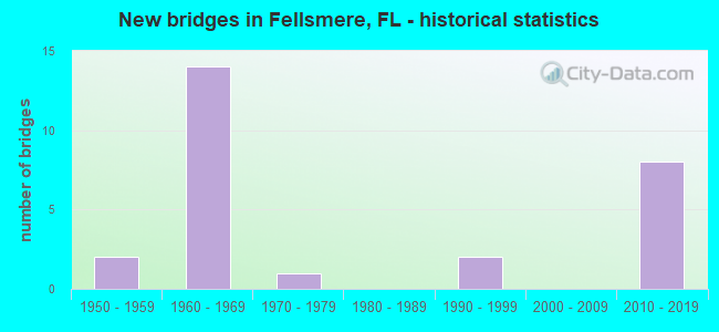
- New bridges - historical statistics
- 21950-1959
- 141960-1969
- 11970-1979
- 21990-1999
- 82010-2019

- Reconstructed bridges - Historical Statistics
- 21980-1989
- 71990-1999


- Bridge Condition - Deck
- 13.0%Very good
- 69.6%Good
- 4.3%Satisfactory
- 13.0%Fair

- Bridge Condition - Superstructure
- 21.7%Very good
- 60.9%Good
- 4.3%Satisfactory
- 13.0%Fair

- Bridge Condition - Substructure
- 13.0%Very good
- 82.6%Good
- 4.3%Satisfactory

- Bridge Condition - Channel
- 8.7%Excellent
- 4.3%Very good
- 43.5%Good
- 43.5%Satisfactory
Find on map >> Show street view
Structure Number: 700231, Location: Over Fellsmere Canal (Lat: 27.825856, Lng: -80.558114), Route carried "on" structure: Interstate 95, Year Built: 2012, Status: Open, Structure Length: 6.16m (20.21ft), Average Daily Traffic: 21,566 (year 2020), Truck Traffic: 18%, Average Future Daily Traffic: 37,416 (year 2042), Design Load: HL 93, Features Intersected: Fellsmere Canal
Minimum Vertical Clearance: 30+ m (98+ ft), Kilometerpoint: 0.389, Lanes on structure: 3, Base Highway Network: Yes, Owner: State Highway Agency, Approaching Roadway Width: 18.9m (62.0ft), Skew: 2 degrees, Material/Design: Prestressed concrete, Design/Construction: Stringer/Multi-beam, Number Of Spans In Main Unit: 3, Length of Maximum Span: 20.4m (66.9ft), Curb-To-Curb Width: 18.9m (62.0ft), Out-to-Out Width: 19.8m (65.0ft)
Condition: Deck: Good, Superstructure: Very good, Substructure: Good, Channel: Excellent, Operating Rating: 52.3 metric tons, Method Used To Determine Operating Rating: Load and Resistance Factor (LRFR), Inventory Rating: 40.4 metric tons, Method Used To Determine Inventory Rating: Load and Resistance Factor (LRFR), Structural Evaluation: Better than present minimum criteria, Deck Geometry: Superior to present desirable criteria, Waterway Adequacy: Equal to present desirable criteria, Approach Roadway Alignment: Equal to present desirable criteria, Designated Inspection Frequency: Every 24 months, Inspection Date: May 2020, Deck Structure Type: Concrete Cast-file-Place
Find on map >> Show street view
Structure Number: 700232, Location: Over Fellsmere Canal (Lat: 27.825897, Lng: -80.557872), Route carried "on" structure: Interstate 95, Year Built: 2012, Status: Open, Structure Length: 6.16m (20.21ft), Average Daily Traffic: 21,566 (year 2020), Truck Traffic: 18%, Average Future Daily Traffic: 37,416 (year 2042), Design Load: HL 93, Features Intersected: Fellsmere Canal
Minimum Vertical Clearance: 30+ m (98+ ft), Kilometerpoint: 0.380, Lanes on structure: 3, Base Highway Network: Yes, Owner: State Highway Agency, Approaching Roadway Width: 16.8m (55.1ft), Skew: 22 degrees, Material/Design: Prestressed concrete, Design/Construction: Stringer/Multi-beam, Number Of Spans In Main Unit: 3, Length of Maximum Span: 20.4m (66.9ft), Curb-To-Curb Width: 16.8m (55.1ft), Out-to-Out Width: 17.7m (58.1ft)
Condition: Deck: Good, Superstructure: Very good, Substructure: Good, Channel: Excellent, Operating Rating: 54.0 metric tons, Method Used To Determine Operating Rating: Load and Resistance Factor (LRFR), Inventory Rating: 41.6 metric tons, Method Used To Determine Inventory Rating: Load and Resistance Factor (LRFR), Structural Evaluation: Better than present minimum criteria, Deck Geometry: Equal to present minimum criteria, Waterway Adequacy: Equal to present desirable criteria, Approach Roadway Alignment: Equal to present desirable criteria, Designated Inspection Frequency: Every 24 months, Inspection Date: May 2020, Deck Structure Type: Concrete Cast-file-Place
Find on map >> Show street view
Structure Number: 700237, Location: Buffer Preserve Drive (Lat: 27.827017, Lng: -80.559183), Route carried "on" structure: Interstate 95, Year Built: 2012, Status: Open, Structure Length: 10.79m (35.40ft), Average Daily Traffic: 21,566 (year 2020), Truck Traffic: 18%, Average Future Daily Traffic: 37,416 (year 2042), Design Load: HL 93, Features Intersected: C-54 Canal
Minimum Vertical Clearance: 30+ m (98+ ft), Kilometerpoint: 0.533, Lanes on structure: 3, Lanes under structure: 2, Base Highway Network: Yes, Owner: State Highway Agency, Approaching Roadway Width: 19.2m (63.0ft), Skew: 6 degrees, Material/Design: Prestressed concrete, Design/Construction: Stringer/Multi-beam, Number Of Spans In Main Unit: 3, Length of Maximum Span: 35.8m (117.5ft), Curb-To-Curb Width: 19.2m (63.0ft), Out-to-Out Width: 20.1m (65.9ft)
Condition: Deck: Good, Superstructure: Very good, Substructure: Good, Channel: Good, Operating Rating: 41.6 metric tons, Method Used To Determine Operating Rating: Load and Resistance Factor (LRFR), Inventory Rating: 35.4 metric tons, Method Used To Determine Inventory Rating: Load and Resistance Factor (LRFR), Structural Evaluation: Better than present minimum criteria, Deck Geometry: Superior to present desirable criteria, Waterway Adequacy: Superior to present desirable criteria, Approach Roadway Alignment: Equal to present desirable criteria, Designated Inspection Frequency: Every 24 months, Underwater Inspection Frequency: Every 24 months, Inspection Date: May 2020, Underwater Inspection Date: May 2020, Deck Structure Type: Concrete Cast-file-Place
Find on map >> Show street view
Structure Number: 700238, Location: Buffer Preserve Drive (Lat: 27.827042, Lng: -80.558944), Route carried "on" structure: Interstate 95, Year Built: 2012, Status: Open, Structure Length: 10.79m (35.40ft), Average Daily Traffic: 21,566 (year 2020), Truck Traffic: 18%, Average Future Daily Traffic: 37,416 (year 2042), Design Load: HL 93, Features Intersected: C-54 Canal
Minimum Vertical Clearance: 30+ m (98+ ft), Kilometerpoint: 0.526, Lanes on structure: 3, Lanes under structure: 2, Base Highway Network: Yes, Owner: State Highway Agency, Approaching Roadway Width: 17.0m (55.8ft), Skew: 6 degrees, Material/Design: Prestressed concrete, Design/Construction: Stringer/Multi-beam, Number Of Spans In Main Unit: 3, Length of Maximum Span: 35.8m (117.5ft), Curb-To-Curb Width: 17.0m (55.8ft), Out-to-Out Width: 17.9m (58.7ft)
Condition: Deck: Good, Superstructure: Very good, Substructure: Good, Channel: Good, Operating Rating: 41.1 metric tons, Method Used To Determine Operating Rating: Load and Resistance Factor (LRFR), Inventory Rating: 35.1 metric tons, Method Used To Determine Inventory Rating: Load and Resistance Factor (LRFR), Structural Evaluation: Better than present minimum criteria, Deck Geometry: Equal to present minimum criteria, Waterway Adequacy: Superior to present desirable criteria, Approach Roadway Alignment: Equal to present desirable criteria, Designated Inspection Frequency: Every 24 months, Underwater Inspection Frequency: Every 24 months, Inspection Date: May 2020, Underwater Inspection Date: May 2020, Deck Structure Type: Concrete Cast-file-Place, Wearing Surface/Protective System: Wearing Surface: Monolithic Concrete
Find on map >> Show street view
Structure Number: 704154, Location: .05 mi N of Indian Rvr Co (Lat: 27.823408, Lng: -80.607264), Route carried "on" structure: County highway 507, Year Built: 1967, Status: Open, Structure Length: 7.92m (25.98ft), Average Daily Traffic: 2,200 (year 2020), Truck Traffic: 5%, Average Future Daily Traffic: 3,817 (year 2042), Design Load: HS 20, Features Intersected: Canal C-54, Facility Carried by Structure: Babcock Street
Minimum Vertical Clearance: 30+ m (98+ ft), Kilometerpoint: 0.060, Lanes on structure: 2, Owner: County Highway Agency, Approaching Roadway Width: 7.6m (24.9ft), Material/Design: Prestressed concrete, Design/Construction: Stringer/Multi-beam, Number Of Spans In Main Unit: 5, Length of Maximum Span: 15.8m (51.8ft), Curb or Sidewalk Widths: Left: 0.5m (1.6ft), Right: 0.5m (1.6ft), Curb-To-Curb Width: 8.5m (27.9ft), Out-to-Out Width: 10.1m (33.1ft)
Condition: Deck: Good, Superstructure: Good, Substructure: Good, Channel: Good, Operating Rating: 51.5 metric tons, Method Used To Determine Operating Rating: Allowable Stress (AS), Inventory Rating: 45.6 metric tons, Method Used To Determine Inventory Rating: Allowable Stress (AS), Structural Evaluation: Better than present minimum criteria, Deck Geometry: Meets minimum limits, Waterway Adequacy: Superior to present desirable criteria, Approach Roadway Alignment: Better than present minimum criteria, Designated Inspection Frequency: Every 24 months, Underwater Inspection Frequency: Every 24 months, Inspection Date: Febuary 2022, Underwater Inspection Date: Febuary 2022, Deck Structure Type: Concrete Cast-file-Place
Find on map >> Show street view
Structure Number: 880041, Location: 1 MI N OF SR-60 (Lat: 27.655467, Lng: -80.643314), Route carried "on" structure: County highway 512, Year Built: 1951, Status: Open, Structure Length: 2.29m (7.51ft), Average Daily Traffic: 650 (year 2022), Truck Traffic: 4%, Average Future Daily Traffic: 1,128 (year 2042), Design Load: HS 15, Features Intersected: DITCH NO. 46
Minimum Vertical Clearance: 30+ m (98+ ft), Kilometerpoint: 1.654, Lanes on structure: 2, Owner: County Highway Agency, Approaching Roadway Width: 8.0m (26.2ft), Material/Design: Concrete, Design/Construction: Slab, Number Of Spans In Main Unit: 5, Length of Maximum Span: 4.6m (15.1ft), Curb or Sidewalk Widths: Left: 0.2m (0.7ft), Right: 0.2m (0.7ft), Curb-To-Curb Width: 6.1m (20.0ft), Out-to-Out Width: 6.6m (21.7ft)
Condition: Deck: Good, Superstructure: Good, Substructure: Good, Channel: Good, Operating Rating: 44.8 metric tons, Method Used To Determine Operating Rating: Load Factor (LF), Inventory Rating: 26.9 metric tons, Method Used To Determine Inventory Rating: Load Factor (LF), Structural Evaluation: Equal to present minimum criteria, Deck Geometry: High priority of corrective action, Waterway Adequacy: Equal to present minimum criteria, Approach Roadway Alignment: Equal to present desirable criteria, Designated Inspection Frequency: Every 24 months, Underwater Inspection Frequency: Every 24 months, Inspection Date: January 2022, Underwater Inspection Date: January 2022, Deck Structure Type: Concrete Cast-file-Place, Wearing Surface/Protective System: Wearing Surface: Bituminous
Find on map >> Show street view
Structure Number: 880042, Location: 3.7 MILES NORTH OF SR-60 (Lat: 27.695508, Lng: -80.642867), Route carried "on" structure: County highway 512, Year Built: 1951, Status: Open, Structure Length: 3.20m (10.50ft), Average Daily Traffic: 650 (year 2022), Truck Traffic: 4%, Average Future Daily Traffic: 1,128 (year 2042), Design Load: H 15, Features Intersected: DITCH NO. 34
Minimum Vertical Clearance: 30+ m (98+ ft), Kilometerpoint: 6.085, Lanes on structure: 2, Owner: County Highway Agency, Approaching Roadway Width: 8.0m (26.2ft), Material/Design: Concrete, Design/Construction: Slab, Number Of Spans In Main Unit: 7, Length of Maximum Span: 4.6m (15.1ft), Curb or Sidewalk Widths: Left: 0.2m (0.7ft), Right: 0.2m (0.7ft), Curb-To-Curb Width: 6.1m (20.0ft), Out-to-Out Width: 6.6m (21.7ft)
Condition: Deck: Good, Superstructure: Good, Substructure: Good, Channel: Good, Operating Rating: 45.6 metric tons, Method Used To Determine Operating Rating: Load Factor (LF), Inventory Rating: 27.4 metric tons, Method Used To Determine Inventory Rating: Load Factor (LF), Structural Evaluation: Equal to present minimum criteria, Deck Geometry: High priority of corrective action, Waterway Adequacy: Equal to present minimum criteria, Approach Roadway Alignment: Equal to present desirable criteria, Designated Inspection Frequency: Every 24 months, Underwater Inspection Frequency: Every 24 months, Inspection Date: January 2022, Underwater Inspection Date: January 2022, Deck Structure Type: Concrete Cast-file-Place, Wearing Surface/Protective System: Wearing Surface: Bituminous
Find on map >> Show street view
Structure Number: 880057, Location: 1.8 MI N OF ST LUCIE CNTY (Lat: 27.559283, Lng: -80.685553), Route carried "on" structure: State highway 91, Year Built: 1963, Status: Open, Structure Length: 4.27m (14.01ft), Average Daily Traffic: 14,350 (year 2022), Truck Traffic: 12%, Average Future Daily Traffic: 24,897 (year 2042), Design Load: HS 20, Features Intersected: OUTFALL CANAL
Minimum Vertical Clearance: 30+ m (98+ ft), Kilometerpoint: 3.701, Lanes on structure: 2, Base Highway Network: Yes, Toll: On toll road, Owner: State Toll Authority, Approaching Roadway Width: 11.8m (38.7ft), Material/Design: Prestressed concrete, Design/Construction: Slab, Number Of Spans In Main Unit: 5, Length of Maximum Span: 8.6m (28.2ft), Curb-To-Curb Width: 11.3m (37.1ft), Out-to-Out Width: 12.1m (39.7ft)
Condition: Deck: Good, Superstructure: Good, Substructure: Good, Channel: Satisfactory, Operating Rating: 57.5 metric tons, Method Used To Determine Operating Rating: Load and Resistance Factor (LRFR), Inventory Rating: 46.7 metric tons, Method Used To Determine Inventory Rating: Load and Resistance Factor (LRFR), Structural Evaluation: Better than present minimum criteria, Deck Geometry: Equal to present minimum criteria, Waterway Adequacy: Equal to present desirable criteria, Approach Roadway Alignment: Better than present minimum criteria, Designated Inspection Frequency: Every 24 months, Underwater Inspection Frequency: Every 24 months, Inspection Date: January 2022, Underwater Inspection Date: January 2022, Deck Structure Type: Concrete Precast Panels, Wearing Surface/Protective System: Wearing Surface: Bituminous
Find on map >> Show street view
Structure Number: 880058, Location: 15 MI S OF SR 60 (Lat: 27.559306, Lng: -80.728450), Route carried "on" structure: State highway 91, Year Built: 1963, Year Reconstructed: 1989, Status: Open, Structure Length: 5.97m (19.59ft), Average Daily Traffic: 14,350 (year 2022), Truck Traffic: 12%, Average Future Daily Traffic: 24,897 (year 2042), Design Load: HS 20+Mod, Features Intersected: OUTFALL SLOUGH
Minimum Vertical Clearance: 30+ m (98+ ft), Kilometerpoint: 7.949, Lanes on structure: 2, Base Highway Network: Yes, Toll: On toll road, Owner: State Toll Authority, Approaching Roadway Width: 12.8m (42.0ft), Material/Design: Prestressed concrete, Design/Construction: Slab, Number Of Spans In Main Unit: 5, Length of Maximum Span: 12.0m (39.4ft), Curb-To-Curb Width: 12.5m (41.0ft), Out-to-Out Width: 13.0m (42.7ft)
Condition: Deck: Good, Superstructure: Good, Substructure: Good, Channel: Satisfactory, Operating Rating: 34.9 metric tons, Method Used To Determine Operating Rating: Load and Resistance Factor (LRFR), Inventory Rating: 30.0 metric tons, Method Used To Determine Inventory Rating: Load and Resistance Factor (LRFR), Structural Evaluation: Better than present minimum criteria, Deck Geometry: Better than present minimum criteria, Waterway Adequacy: Better than present minimum criteria, Approach Roadway Alignment: Equal to present desirable criteria, Designated Inspection Frequency: Every 24 months, Inspection Date: January 2022, Deck Structure Type: Concrete Precast Panels
Find on map >> Show street view
Structure Number: 880059, Location: 13 MI SOUTH OF SR 60 (Lat: 27.559289, Lng: -80.762908), Route carried "on" structure: State highway 91, Year Built: 1963, Year Reconstructed: 1990, Status: Open, Structure Length: 2.50m (8.20ft), Average Daily Traffic: 14,350 (year 2022), Truck Traffic: 12%, Average Future Daily Traffic: 24,897 (year 2042), Design Load: HS 20+Mod, Features Intersected: OUTFALL SLOUGH
Minimum Vertical Clearance: 30+ m (98+ ft), Kilometerpoint: 11.386, Lanes on structure: 2, Base Highway Network: Yes, Toll: On toll road, Owner: State Toll Authority, Approaching Roadway Width: 11.8m (38.7ft), Material/Design: Prestressed concrete, Design/Construction: Slab, Number Of Spans In Main Unit: 3, Length of Maximum Span: 8.3m (27.2ft), Curb-To-Curb Width: 11.3m (37.1ft), Out-to-Out Width: 12.1m (39.7ft)
Condition: Deck: Good, Superstructure: Good, Substructure: Good, Channel: Satisfactory, Operating Rating: 60.1 metric tons, Method Used To Determine Operating Rating: Load and Resistance Factor (LRFR), Inventory Rating: 51.0 metric tons, Method Used To Determine Inventory Rating: Load and Resistance Factor (LRFR), Structural Evaluation: Better than present minimum criteria, Deck Geometry: Equal to present minimum criteria, Waterway Adequacy: Equal to present desirable criteria, Approach Roadway Alignment: Equal to present desirable criteria, Designated Inspection Frequency: Every 24 months, Inspection Date: January 2022, Deck Structure Type: Concrete Precast Panels, Wearing Surface/Protective System: Wearing Surface: Bituminous
Find on map >> Show street view
Structure Number: 88006, Location: 1.4 MI S OF OSCEOLA CNTY (Lat: 27.649769, Lng: -80.858628), Route carried "on" structure: State highway 91, Year Built: 1962, Year Reconstructed: 1990, Status: Open, Structure Length: 4.27m (14.01ft), Average Daily Traffic: 14,350 (year 2022), Truck Traffic: 12%, Average Future Daily Traffic: 24,897 (year 2042), Design Load: HS 20+Mod, Features Intersected: OUTFALL SLOUGH
Minimum Vertical Clearance: 30+ m (98+ ft), Kilometerpoint: 25.835, Lanes on structure: 2, Base Highway Network: Yes, Toll: On toll road, Owner: State Toll Authority, Approaching Roadway Width: 12.1m (39.7ft), Material/Design: Prestressed concrete, Design/Construction: Slab, Number Of Spans In Main Unit: 5, Length of Maximum Span: 8.5m (27.9ft), Curb-To-Curb Width: 11.3m (37.1ft), Out-to-Out Width: 12.1m (39.7ft)
Condition: Deck: Good, Superstructure: Good, Substructure: Good, Channel: Satisfactory, Operating Rating: 56.2 metric tons, Method Used To Determine Operating Rating: Load and Resistance Factor (LRFR), Inventory Rating: 48.0 metric tons, Method Used To Determine Inventory Rating: Load and Resistance Factor (LRFR), Structural Evaluation: Better than present minimum criteria, Deck Geometry: Equal to present minimum criteria, Waterway Adequacy: Equal to present desirable criteria, Approach Roadway Alignment: Equal to present desirable criteria, Designated Inspection Frequency: Every 24 months, Inspection Date: January 2022, Deck Structure Type: Concrete Precast Panels, Wearing Surface/Protective System: Wearing Surface: Bituminous
Find on map >> Show street view
Structure Number: 880065, Location: 1.8 MI N OF ST LUCIE CNTY (Lat: 27.559483, Lng: -80.685539), Route carried "on" structure: State highway 91, Year Built: 1963, Status: Open, Structure Length: 4.32m (14.17ft), Average Daily Traffic: 14,350 (year 2022), Truck Traffic: 12%, Average Future Daily Traffic: 24,897 (year 2042), Design Load: HS 20, Features Intersected: OUTFALL CANAL
Minimum Vertical Clearance: 30+ m (98+ ft), Kilometerpoint: 3.701, Lanes on structure: 2, Base Highway Network: Yes, Toll: On toll road, Owner: State Toll Authority, Approaching Roadway Width: 11.8m (38.7ft), Material/Design: Prestressed concrete, Design/Construction: Slab, Number Of Spans In Main Unit: 5, Length of Maximum Span: 8.6m (28.2ft), Curb-To-Curb Width: 11.3m (37.1ft), Out-to-Out Width: 12.1m (39.7ft)
Condition: Deck: Good, Superstructure: Good, Substructure: Good, Channel: Satisfactory, Operating Rating: 57.5 metric tons, Method Used To Determine Operating Rating: Load and Resistance Factor (LRFR), Inventory Rating: 46.7 metric tons, Method Used To Determine Inventory Rating: Load and Resistance Factor (LRFR), Structural Evaluation: Better than present minimum criteria, Deck Geometry: Equal to present minimum criteria, Waterway Adequacy: Equal to present desirable criteria, Approach Roadway Alignment: Equal to present desirable criteria, Designated Inspection Frequency: Every 24 months, Underwater Inspection Frequency: Every 24 months, Inspection Date: January 2022, Underwater Inspection Date: January 2022, Deck Structure Type: Concrete Precast Panels, Wearing Surface/Protective System: Wearing Surface: Bituminous
Find on map >> Show street view
Structure Number: 880066, Location: 15 MI SOUTH OF SR 60 (Lat: 27.559486, Lng: -80.728428), Route carried "on" structure: State highway 91, Year Built: 1963, Year Reconstructed: 1990, Status: Open, Structure Length: 5.97m (19.59ft), Average Daily Traffic: 14,350 (year 2022), Truck Traffic: 12%, Average Future Daily Traffic: 24,897 (year 2042), Design Load: HS 20+Mod, Features Intersected: OUTFALL SLOUGH
Minimum Vertical Clearance: 30+ m (98+ ft), Kilometerpoint: 7.949, Lanes on structure: 2, Base Highway Network: Yes, Toll: On toll road, Owner: State Toll Authority, Approaching Roadway Width: 12.8m (42.0ft), Material/Design: Prestressed concrete, Design/Construction: Slab, Number Of Spans In Main Unit: 5, Length of Maximum Span: 12.1m (39.7ft), Curb-To-Curb Width: 12.2m (40.0ft), Out-to-Out Width: 13.0m (42.7ft)
Condition: Deck: Good, Superstructure: Good, Substructure: Good, Channel: Satisfactory, Operating Rating: 34.9 metric tons, Method Used To Determine Operating Rating: Load and Resistance Factor (LRFR), Inventory Rating: 30.0 metric tons, Method Used To Determine Inventory Rating: Load and Resistance Factor (LRFR), Structural Evaluation: Better than present minimum criteria, Deck Geometry: Better than present minimum criteria, Waterway Adequacy: Equal to present minimum criteria, Approach Roadway Alignment: Equal to present desirable criteria, Designated Inspection Frequency: Every 24 months, Inspection Date: January 2022, Deck Structure Type: Concrete Precast Panels
Find on map >> Show street view
Structure Number: 880067, Location: 13 MI S OF SR 60 (Lat: 27.559478, Lng: -80.762906), Route carried "on" structure: State highway 91, Year Built: 1963, Year Reconstructed: 1990, Status: Open, Structure Length: 2.50m (8.20ft), Average Daily Traffic: 14,350 (year 2022), Truck Traffic: 12%, Average Future Daily Traffic: 24,897 (year 2042), Design Load: HS 20+Mod, Features Intersected: OUTFALL SLOUGH
Minimum Vertical Clearance: 30+ m (98+ ft), Kilometerpoint: 11.386, Lanes on structure: 2, Base Highway Network: Yes, Toll: On toll road, Owner: State Toll Authority, Approaching Roadway Width: 11.8m (38.7ft), Material/Design: Prestressed concrete, Design/Construction: Slab, Number Of Spans In Main Unit: 3, Length of Maximum Span: 8.3m (27.2ft), Curb-To-Curb Width: 11.3m (37.1ft), Out-to-Out Width: 12.1m (39.7ft)
Condition: Deck: Good, Superstructure: Good, Substructure: Good, Channel: Satisfactory, Operating Rating: 60.1 metric tons, Method Used To Determine Operating Rating: Load and Resistance Factor (LRFR), Inventory Rating: 51.0 metric tons, Method Used To Determine Inventory Rating: Load and Resistance Factor (LRFR), Structural Evaluation: Better than present minimum criteria, Deck Geometry: Equal to present minimum criteria, Waterway Adequacy: Equal to present desirable criteria, Approach Roadway Alignment: Equal to present desirable criteria, Designated Inspection Frequency: Every 24 months, Inspection Date: January 2022, Deck Structure Type: Concrete Precast Panels, Wearing Surface/Protective System: Wearing Surface: Bituminous
Find on map >> Show street view
Structure Number: 880068, Location: 1.4 MI S OF OSCEOLA CNTY (Lat: 27.649869, Lng: -80.858442), Route carried "on" structure: State highway 91, Year Built: 1964, Year Reconstructed: 1990, Status: Open, Structure Length: 4.27m (14.01ft), Average Daily Traffic: 14,350 (year 2022), Truck Traffic: 12%, Average Future Daily Traffic: 24,897 (year 2042), Design Load: HS 20+Mod, Features Intersected: OUTFALL SLOUGH
Minimum Vertical Clearance: 30+ m (98+ ft), Kilometerpoint: 25.835, Lanes on structure: 2, Base Highway Network: Yes, Toll: On toll road, Owner: State Toll Authority, Approaching Roadway Width: 11.8m (38.7ft), Material/Design: Prestressed concrete, Design/Construction: Slab, Number Of Spans In Main Unit: 5, Length of Maximum Span: 8.5m (27.9ft), Curb-To-Curb Width: 11.3m (37.1ft), Out-to-Out Width: 12.1m (39.7ft)
Condition: Deck: Good, Superstructure: Good, Substructure: Good, Channel: Satisfactory, Operating Rating: 56.2 metric tons, Method Used To Determine Operating Rating: Load and Resistance Factor (LRFR), Inventory Rating: 48.0 metric tons, Method Used To Determine Inventory Rating: Load and Resistance Factor (LRFR), Structural Evaluation: Better than present minimum criteria, Deck Geometry: Equal to present minimum criteria, Waterway Adequacy: Equal to present minimum criteria, Approach Roadway Alignment: Equal to present desirable criteria, Designated Inspection Frequency: Every 24 months, Inspection Date: January 2022, Deck Structure Type: Concrete Precast Panels, Wearing Surface/Protective System: Wearing Surface: Bituminous
Find on map >> Show street view
Structure Number: 880076, Location: 4.2MI N OF CR-512 (Lat: 27.822081, Lng: -80.607122), Route carried "on" structure: County highway 507, Year Built: 1975, Status: Open, Structure Length: 6.37m (20.90ft), Average Daily Traffic: 2,059 (year 2021), Truck Traffic: 10%, Average Future Daily Traffic: 3,572 (year 2042), Design Load: HS 20, Features Intersected: FELLSMERE CANAL
Minimum Vertical Clearance: 30+ m (98+ ft), Kilometerpoint: 27.243, Lanes on structure: 2, Owner: County Highway Agency, Approaching Roadway Width: 9.8m (32.2ft), Material/Design: Prestressed concrete, Design/Construction: Stringer/Multi-beam, Number Of Spans In Main Unit: 3, Length of Maximum Span: 21.2m (69.6ft), Curb-To-Curb Width: 13.4m (44.0ft), Out-to-Out Width: 14.1m (46.3ft)
Condition: Deck: Good, Superstructure: Good, Substructure: Good, Channel: Good, Operating Rating: 72.3 metric tons, Method Used To Determine Operating Rating: Allowable Stress (AS), Inventory Rating: 34.0 metric tons, Method Used To Determine Inventory Rating: Allowable Stress (AS), Structural Evaluation: Better than present minimum criteria, Deck Geometry: Better than present minimum criteria, Waterway Adequacy: Better than present minimum criteria, Approach Roadway Alignment: Better than present minimum criteria, Designated Inspection Frequency: Every 24 months, Inspection Date: October 2021, Deck Structure Type: Concrete Cast-file-Place
Find on map >> Show street view
Structure Number: 880105, Location: 9 miles N of SR-60 (Lat: 27.767694, Lng: -80.551333), Route carried "on" structure: Interstate 95, Year Built: 2016, Status: Open, Structure Length: 5.86m (19.23ft), Average Daily Traffic: 39,500 (year 2020), Truck Traffic: 19%, Average Future Daily Traffic: 68,532 (year 2042), Design Load: HL 93, Features Intersected: CR 512 (Fellsmere Rd.)
Minimum Vertical Clearance: 30+ m (98+ ft), Kilometerpoint: 24.452, Lanes on structure: 6, Lanes under structure: 7, Base Highway Network: Yes, Owner: State Highway Agency, Approaching Roadway Width: 35.4m (116.1ft), Skew: 30 degrees, Material/Design: Prestressed concrete, Design/Construction: Stringer/Multi-beam, Number Of Spans In Main Unit: 2, Length of Maximum Span: 29.3m (96.1ft), Curb-To-Curb Width: 35.4m (116.1ft), Out-to-Out Width: 36.9m (121.1ft)
Condition: Deck: Very good, Superstructure: Good, Substructure: Very good, Operating Rating: 48.4 metric tons, Method Used To Determine Operating Rating: Load and Resistance Factor (LRFR), Inventory Rating: 44.1 metric tons, Method Used To Determine Inventory Rating: Load and Resistance Factor (LRFR), Structural Evaluation: Better than present minimum criteria, Deck Geometry: Superior to present desirable criteria, Underclear: Superior to present desirable criteria, Approach Roadway Alignment: Equal to present desirable criteria, Designated Inspection Frequency: Every 24 months, Inspection Date: Febuary 2022, Deck Structure Type: Concrete Cast-file-Place
Find on map >> Show street view
Structure Number: 880107, Location: 4.2 Miles N of SR 60 (Lat: 27.696317, Lng: -80.538647), Route carried "on" structure: Interstate 95, Year Built: 1968, Status: Open, Structure Length: 0.87m (2.85ft), Average Daily Traffic: 39,500 (year 2020), Truck Traffic: 19%, Average Future Daily Traffic: 68,532 (year 2042), Design Load: HL 93, Features Intersected: Relief Canal
Minimum Vertical Clearance: 30+ m (98+ ft), Kilometerpoint: 16.544, Lanes on structure: 6, Base Highway Network: Yes, Owner: State Highway Agency, Approaching Roadway Width: 17.1m (56.1ft), Skew: 12 degrees, Material/Design: Concrete, Design/Construction: Culvert, Number Of Spans In Main Unit: 3, Length of Maximum Span: 2.7m (8.9ft)
Condition: Channel: Good, Culverts: Satisfactory, Operating Rating: 88.8 metric tons, Method Used To Determine Operating Rating: Load and Resistance Factor (LRFR), Inventory Rating: 68.6 metric tons, Method Used To Determine Inventory Rating: Load and Resistance Factor (LRFR), Structural Evaluation: Equal to present minimum criteria, Waterway Adequacy: Superior to present desirable criteria, Approach Roadway Alignment: Equal to present desirable criteria, Designated Inspection Frequency: Every 24 months, Inspection Date: April 2020
Find on map >> Show street view
Structure Number: 884003, Location: AT 141st ST (Lat: 27.771986, Lng: -80.614319), Route carried "on" structure: City street , Year Built: 1963, Year Reconstructed: 1993, Status: Open, Structure Length: 2.29m (7.51ft), Average Daily Traffic: 101 (year 2021), Truck Traffic: 2%, Average Future Daily Traffic: 126 (year 2042), Design Load: H 10, Features Intersected: PARK LATERAL CANAL, Facility Carried by Structure: 97 TH STREET
Minimum Vertical Clearance: 30+ m (98+ ft), Kilometerpoint: 0.000, Lanes on structure: 2, Owner: County Highway Agency, Approaching Roadway Width: 5.6m (18.4ft), Material/Design: Concrete, Design/Construction: Slab, Number Of Spans In Main Unit: 5, Length of Maximum Span: 4.6m (15.1ft), Curb or Sidewalk Widths: Left: 0.2m (0.7ft), Right: 0.2m (0.7ft), Curb-To-Curb Width: 6.1m (20.0ft), Out-to-Out Width: 6.5m (21.3ft)
Condition: Deck: Fair, Superstructure: Fair, Substructure: Good, Channel: Satisfactory, Operating Rating: 36.5 metric tons, Method Used To Determine Operating Rating: Load Factor (LF), Inventory Rating: 21.9 metric tons, Method Used To Determine Inventory Rating: Load Factor (LF), Structural Evaluation: Somewhat better than minimum adequacy, Deck Geometry: Meets minimum limits, Waterway Adequacy: Equal to present desirable criteria, Approach Roadway Alignment: Equal to present minimum criteria, Designated Inspection Frequency: Every 24 months, Inspection Date: October 2021, Deck Structure Type: Concrete Precast Panels
Find on map >> Show street view
Structure Number: 88402, Location: 2.6MI N OF SR-60 (Lat: 27.677464, Lng: -80.495325), Route carried "on" structure: County highway 619, Year Built: 1964, Status: Open, Structure Length: 1.83m (6.00ft), Average Daily Traffic: 600 (year 2022), Truck Traffic: 10%, Average Future Daily Traffic: 1,041 (year 2042), Design Load: H 10, Features Intersected: RELIEF CANAL
Minimum Vertical Clearance: 30+ m (98+ ft), Kilometerpoint: 3.428, Lanes on structure: 2, Owner: County Highway Agency, Approaching Roadway Width: 7.0m (23.0ft), Material/Design: Concrete, Design/Construction: Slab, Number Of Spans In Main Unit: 4, Length of Maximum Span: 4.6m (15.1ft), Curb or Sidewalk Widths: Left: 0.1m (0.3ft), Right: 0.1m (0.3ft), Curb-To-Curb Width: 7.3m (24.0ft), Out-to-Out Width: 7.8m (25.6ft)
Condition: Deck: Satisfactory, Superstructure: Satisfactory, Substructure: Satisfactory, Channel: Satisfactory, Operating Rating: 37.0 metric tons, Method Used To Determine Operating Rating: Load Factor (LF), Inventory Rating: 22.2 metric tons, Method Used To Determine Inventory Rating: Load Factor (LF), Structural Evaluation: Somewhat better than minimum adequacy, Deck Geometry: Meets minimum limits, Waterway Adequacy: Better than present minimum criteria, Approach Roadway Alignment: Equal to present desirable criteria, Designated Inspection Frequency: Every 24 months, Inspection Date: January 2022, Deck Structure Type: Concrete Precast Panels
Find on map >> Show street view
Structure Number: 884063, Location: 0.3MI W OF CR-507 (Lat: 27.779242, Lng: -80.614406), Route carried "on" structure: County highway , Year Built: 1964, Year Reconstructed: 1998, Status: Open, Structure Length: 2.29m (7.51ft), Average Daily Traffic: 101 (year 2021), Truck Traffic: 3%, Average Future Daily Traffic: 126 (year 2042), Design Load: H 10, Features Intersected: PARK LATERAL CANAL, Facility Carried by Structure: 101ST STREET
Minimum Vertical Clearance: 30+ m (98+ ft), Kilometerpoint: 0.000, Lanes on structure: 2, Owner: County Highway Agency, Approaching Roadway Width: 5.5m (18.0ft), Material/Design: Concrete, Design/Construction: Slab, Number Of Spans In Main Unit: 5, Length of Maximum Span: 4.6m (15.1ft), Curb or Sidewalk Widths: Left: 0.2m (0.7ft), Right: 0.2m (0.7ft), Curb-To-Curb Width: 6.1m (20.0ft), Out-to-Out Width: 6.5m (21.3ft)
Condition: Deck: Fair, Superstructure: Fair, Substructure: Good, Channel: Good, Operating Rating: 37.3 metric tons, Method Used To Determine Operating Rating: Load Factor (LF), Inventory Rating: 22.3 metric tons, Method Used To Determine Inventory Rating: Load Factor (LF), Structural Evaluation: Somewhat better than minimum adequacy, Deck Geometry: Meets minimum limits, Waterway Adequacy: Equal to present desirable criteria, Approach Roadway Alignment: Equal to present minimum criteria, Designated Inspection Frequency: Every 24 months, Inspection Date: October 2021, Deck Structure Type: Concrete Precast Panels
Find on map >> Show street view
Structure Number: 884064, Location: 0.3MI WEST OF CR-507 (Lat: 27.793917, Lng: -80.614011), Route carried "on" structure: Other road , Year Built: 1960, Year Reconstructed: 1998, Status: Open, Structure Length: 2.29m (7.51ft), Average Daily Traffic: 101 (year 2021), Truck Traffic: 2%, Average Future Daily Traffic: 126 (year 2042), Design Load: H 10, Features Intersected: PARK LATERAL CANAL, Facility Carried by Structure: 109TH STREET
Minimum Vertical Clearance: 30+ m (98+ ft), Kilometerpoint: 0.000, Lanes on structure: 2, Owner: County Highway Agency, Approaching Roadway Width: 5.2m (17.1ft), Material/Design: Concrete, Design/Construction: Slab, Number Of Spans In Main Unit: 5, Length of Maximum Span: 4.6m (15.1ft), Curb or Sidewalk Widths: Left: 0.2m (0.7ft), Right: 0.2m (0.7ft), Curb-To-Curb Width: 6.1m (20.0ft), Out-to-Out Width: 6.5m (21.3ft)
Condition: Deck: Fair, Superstructure: Fair, Substructure: Good, Channel: Good, Operating Rating: 48.8 metric tons, Method Used To Determine Operating Rating: Load Factor (LF), Inventory Rating: 29.3 metric tons, Method Used To Determine Inventory Rating: Load Factor (LF), Structural Evaluation: Somewhat better than minimum adequacy, Deck Geometry: Meets minimum limits, Waterway Adequacy: Equal to present desirable criteria, Approach Roadway Alignment: Equal to present minimum criteria, Designated Inspection Frequency: Every 24 months, Inspection Date: October 2021, Deck Structure Type: Concrete Precast Panels
Find on map >> Show street view
Structure Number: 884067, Location: 7MI NORTH OF SR-60 (Lat: 27.739778, Lng: -80.641994), Route carried "on" structure: County highway 512, Year Built: 1999, Status: Open, Structure Length: 1.70m (5.58ft), Average Daily Traffic: 910 (year 2021), Truck Traffic: 25%, Average Future Daily Traffic: 1,092 (year 2042), Design Load: HS 20+Mod, Features Intersected: LATERAL U CANAL
Minimum Vertical Clearance: 30+ m (98+ ft), Kilometerpoint: 0.018, Lanes on structure: 2, Owner: County Highway Agency, Approaching Roadway Width: 7.3m (24.0ft), Material/Design: Prestressed concrete, Design/Construction: Stringer/Multi-beam, Number Of Spans In Main Unit: 1, Length of Maximum Span: 17.0m (55.8ft), Curb or Sidewalk Widths: Left: 0.0m, Right: 1.8m (5.9ft), Curb-To-Curb Width: 12.1m (39.7ft), Out-to-Out Width: 17.7m (58.1ft)
Condition: Deck: Very good, Superstructure: Very good, Substructure: Very good, Channel: Very good, Operating Rating: 71.7 metric tons, Method Used To Determine Operating Rating: Load Factor (LF), Inventory Rating: 43.0 metric tons, Method Used To Determine Inventory Rating: Load Factor (LF), Structural Evaluation: Equal to present desirable criteria, Deck Geometry: Better than present minimum criteria, Waterway Adequacy: Equal to present desirable criteria, Approach Roadway Alignment: Equal to present desirable criteria, Designated Inspection Frequency: Every 24 months, Inspection Date: October 2021, Deck Structure Type: Concrete Cast-file-Place
Find on map >> Show street view
Structure Number: 884068, Location: 9.2MI N OF SR-60 (Lat: 27.761425, Lng: -80.614442), Route carried "on" structure: County highway 512, Year Built: 1999, Status: Open, Structure Length: 2.29m (7.51ft), Average Daily Traffic: 1,500 (year 2021), Truck Traffic: 20%, Average Future Daily Traffic: 1,800 (year 2042), Design Load: HS 20+Mod, Features Intersected: PARK LATERAL CANAL
Minimum Vertical Clearance: 30+ m (98+ ft), Kilometerpoint: 3.677, Lanes on structure: 2, Owner: County Highway Agency, Approaching Roadway Width: 9.6m (31.5ft), Skew: 4 degrees, Material/Design: Prestressed concrete, Design/Construction: Stringer/Multi-beam, Number Of Spans In Main Unit: 1, Length of Maximum Span: 22.9m (75.1ft), Curb or Sidewalk Widths: Left: 1.8m (5.9ft), Right: 0.0m, Curb-To-Curb Width: 12.3m (40.4ft), Out-to-Out Width: 17.9m (58.7ft)
Condition: Deck: Very good, Superstructure: Good, Substructure: Very good, Channel: Good, Operating Rating: 66.6 metric tons, Method Used To Determine Operating Rating: Load Factor (LF), Inventory Rating: 39.9 metric tons, Method Used To Determine Inventory Rating: Load Factor (LF), Structural Evaluation: Better than present minimum criteria, Deck Geometry: Better than present minimum criteria, Waterway Adequacy: Equal to present desirable criteria, Approach Roadway Alignment: Equal to present desirable criteria, Designated Inspection Frequency: Every 24 months, Inspection Date: October 2021, Deck Structure Type: Concrete Cast-file-Place
Find on map >> Show street view
Structure Number: 700237, Location: Buffer Preserve Drive (Lat: 27.827017, Lng: -80.559183), Route carried "under" structure: County highway , Year Built: 2012, Structure Length: 0. m, Average Daily Traffic: 100 (year 2021), Truck Traffic: 2%, Features Intersected: C-54 Canal, Facility Carried by Structure: I-95 SB
Minimum Vertical Clearance: 4.73m (15.52ft), Kilometerpoint: 0.000, Lanes on structure: 3, Lanes under structure: 2, Material/Design: Prestressed concrete, Design/Construction: Stringer/Multi-beam, Length of Maximum Span: 35.8m (117.5ft)
Find on map >> Show street view
Structure Number: 700238, Location: Buffer Preserve Drive (Lat: 27.827042, Lng: -80.558944), Route carried "under" structure: County highway , Year Built: 2012, Structure Length: 0. m, Average Daily Traffic: 100 (year 2021), Truck Traffic: 1%, Features Intersected: C-54 Canal, Facility Carried by Structure: I-95 NB
Minimum Vertical Clearance: 4.94m (16.21ft), Kilometerpoint: 0.000, Lanes on structure: 3, Lanes under structure: 2, Material/Design: Prestressed concrete, Design/Construction: Stringer/Multi-beam, Length of Maximum Span: 35.8m (117.5ft)
Find on map >> Show street view
Structure Number: 880105, Location: 9 miles N of SR-60 (Lat: 27.767694, Lng: -80.551333), Route carried "under" structure: County highway 512, Year Built: 2016, Structure Length: 0. m, Average Daily Traffic: 11,800 (year 2020), Truck Traffic: 10%, Features Intersected: CR 512 (Fellsmere Rd.), Facility Carried by Structure: SR 9 (I-95)
Minimum Vertical Clearance: 5.18m (16.99ft), Kilometerpoint: 38.851, Lanes on structure: 6, Lanes under structure: 7, Material/Design: Prestressed concrete, Design/Construction: Stringer/Multi-beam, Length of Maximum Span: 29.3m (96.1ft)