Bridge Statistics for Ferry Pass, Florida (FL)
Condition, Traffic, Stress, Structural Evaluation, Project Costs
- National Bridge Inventory (NBI) Statistics
- 11Number of bridges
- 361ft / 110mTotal length
- 138,350Total average daily traffic
- 12,419Total average daily truck traffic
- National Bridge Inventory (NBI) Registered Bridges for Ferry Pass
- No street view available for this location
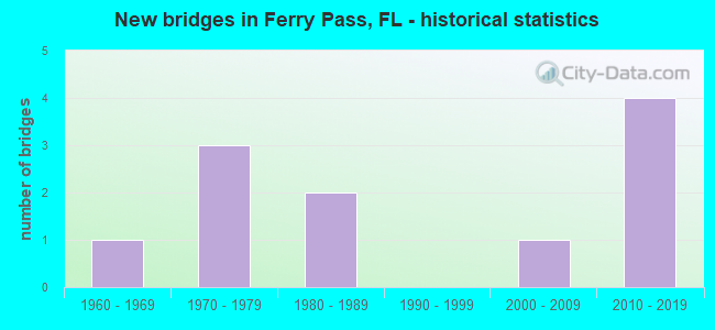
- New bridges - historical statistics
- 11960-1969
- 31970-1979
- 21980-1989
- 12000-2009
- 42010-2019


- Bridge Condition - Deck
- 50.0%Good
- 25.0%Satisfactory
- 25.0%Fair

- Bridge Condition - Superstructure
- 75.0%Good
- 25.0%Fair

- Bridge Condition - Substructure
- 25.0%Very good
- 75.0%Good

- Bridge Condition - Channel
- 14.3%Excellent
- 14.3%Very good
- 28.6%Good
- 28.6%Satisfactory
- 14.3%Fair

- Bridge Condition - Culverts
- 60.0%Good
- 40.0%Satisfactory
Find on map >> Show street view
Structure Number: 480197, Location: 5.4Mi East of US29 (Lat: 30.548992, Lng: -87.195019), Route carried "on" structure: US 90, Year Built: 2003, Status: Open, Structure Length: 79.25m (260.01ft), Average Daily Traffic: 20,750 (year 2020), Truck Traffic: 5%, Average Future Daily Traffic: 36,001 (year 2042), Design Load: H 20, Features Intersected: Escambia River
Minimum Vertical Clearance: 30+ m (98+ ft), Kilometerpoint: 25.476, Lanes on structure: 2, Base Highway Network: Yes, Owner: State Highway Agency, Approaching Roadway Width: 9.8m (32.2ft), Navigation Control: Yes ( Vertical Clearance: 13.9m (45.6ft), Horizontal Clearance: 27.4m (89.9ft)), Material/Design: Prestressed concrete continuous, Design/Construction: Stringer/Multi-beam, Number Of Spans In Main Unit: 21, Length of Maximum Span: 64.2m (210.6ft), Curb-To-Curb Width: 16.8m (55.1ft), Out-to-Out Width: 17.7m (58.1ft)
Condition: Deck: Satisfactory, Superstructure: Good, Substructure: Good, Channel: Very good, Operating Rating: 56.4 metric tons, Method Used To Determine Operating Rating: Load Factor (LF), Inventory Rating: 34.0 metric tons, Method Used To Determine Inventory Rating: Load Factor (LF), Structural Evaluation: Better than present minimum criteria, Deck Geometry: Superior to present desirable criteria, Waterway Adequacy: Superior to present desirable criteria, Approach Roadway Alignment: Equal to present desirable criteria, Designated Inspection Frequency: Every 24 months, Underwater Inspection Frequency: Every 24 months, Inspection Date: March 2020, Underwater Inspection Date: March 2020, Deck Structure Type: Concrete Cast-file-Place
Find on map >> Show street view
Structure Number: 48023, Location: 0.1 Mi W of Escambia Bay (Lat: 30.506556, Lng: -87.162694), Route carried "on" structure: US 90, Year Built: 2015, Status: Open, Structure Length: 6.52m (21.39ft), Average Daily Traffic: 17,400 (year 2020), Truck Traffic: 2%, Average Future Daily Traffic: 30,189 (year 2042), Design Load: HL 93, Features Intersected: I10 SR8
Minimum Vertical Clearance: 30+ m (98+ ft), Kilometerpoint: 37.631, Lanes on structure: 4, Lanes under structure: 8, Base Highway Network: Yes, Owner: State Highway Agency, Approaching Roadway Width: 10.4m (34.1ft), Skew: 20 degrees, Material/Design: Prestressed concrete, Design/Construction: Stringer/Multi-beam, Number Of Spans In Main Unit: 2, Length of Maximum Span: 34.4m (112.9ft), Curb or Sidewalk Widths: Left: 0.0m, Right: 3.7m (12.1ft), Curb-To-Curb Width: 21.0m (68.9ft), Out-to-Out Width: 25.9m (85.0ft)
Condition: Deck: Good, Superstructure: Good, Substructure: Very good, Operating Rating: 62.7 metric tons, Method Used To Determine Operating Rating: Load and Resistance Factor (LRFR), Inventory Rating: 48.3 metric tons, Method Used To Determine Inventory Rating: Load and Resistance Factor (LRFR), Structural Evaluation: Better than present minimum criteria, Deck Geometry: Superior to present desirable criteria, Underclear: Better than present minimum criteria, Approach Roadway Alignment: Equal to present desirable criteria, Designated Inspection Frequency: Every 24 months, Inspection Date: May 2020, Deck Structure Type: Concrete Cast-file-Place
Find on map >> Show street view
Structure Number: 48092, Location: 0.8 mi W of US90 SR10A (Lat: 30.533972, Lng: -87.205522), Route carried "on" structure: US 90A, Year Built: 1970, Status: Open, Structure Length: 7.39m (24.25ft), Average Daily Traffic: 7,550 (year 2020), Truck Traffic: 2%, Average Future Daily Traffic: 13,099 (year 2042), Design Load: HL 93, Features Intersected: SR291 Davis
Minimum Vertical Clearance: 30+ m (98+ ft), Kilometerpoint: 23.710, Lanes on structure: 2, Lanes under structure: 2, Base Highway Network: Yes, Owner: State Highway Agency, Approaching Roadway Width: 9.8m (32.2ft), Skew: 5 degrees, Material/Design: Prestressed concrete, Design/Construction: Stringer/Multi-beam, Number Of Spans In Main Unit: 3, Length of Maximum Span: 35.2m (115.5ft), Curb-To-Curb Width: 11.9m (39.0ft), Out-to-Out Width: 13.0m (42.7ft)
Condition: Deck: Good, Superstructure: Good, Substructure: Good, Operating Rating: 50.0 metric tons, Method Used To Determine Operating Rating: Load and Resistance Factor (LRFR), Inventory Rating: 27.1 metric tons, Method Used To Determine Inventory Rating: Load and Resistance Factor (LRFR), Structural Evaluation: Equal to present minimum criteria, Deck Geometry: Better than present minimum criteria, Underclear: Somewhat better than minimum adequacy, Approach Roadway Alignment: Equal to present desirable criteria, Designated Inspection Frequency: Every 24 months, Inspection Date: March 2020, Deck Structure Type: Concrete Cast-file-Place
Find on map >> Show street view
Structure Number: 484089, Location: 0.09 Mi E of Scenic Hills (Lat: 30.535694, Lng: -87.230278), Route carried "on" structure: County highway , Year Built: 1960, Status: Open, Structure Length: 1.25m (4.10ft), Average Daily Traffic: 700 (year 2021), Average Future Daily Traffic: 1,215 (year 2042), Features Intersected: Unnamed Branch, Facility Carried by Structure: Meadow Brook Drive
Minimum Vertical Clearance: 30+ m (98+ ft), Kilometerpoint: 0.135, Lanes on structure: 2, Owner: County Highway Agency, Approaching Roadway Width: 7.6m (24.9ft), Material/Design: Steel, Design/Construction: Culvert, Number Of Spans In Main Unit: 3, Length of Maximum Span: 4.4m (14.4ft)
Condition: Channel: Fair, Culverts: Satisfactory, Structural Evaluation: Equal to present minimum criteria, Waterway Adequacy: Better than present minimum criteria, Approach Roadway Alignment: Equal to present minimum criteria, Designated Inspection Frequency: Every 24 months, Underwater Inspection Frequency: Every 24 months, Inspection Date: May 2021, Underwater Inspection Date: May 2021
Find on map >> Show street view
Structure Number: 484236, Location: 0.06Mi W of Fox Run Road (Lat: 30.539722, Lng: -87.240833), Route carried "on" structure: County highway , Year Built: 1981, Status: Open, Structure Length: 0.63m (2.07ft), Average Daily Traffic: 50 (year 2021), Average Future Daily Traffic: 87 (year 2042), Design Load: HL 93, Features Intersected: Unnamed Creek, Facility Carried by Structure: Creek Bridge Road
Minimum Vertical Clearance: 30+ m (98+ ft), Kilometerpoint: 0.000, Lanes on structure: 2, Owner: County Highway Agency, Approaching Roadway Width: 8.2m (26.9ft), Material/Design: Concrete, Design/Construction: Culvert, Number Of Spans In Main Unit: 2, Length of Maximum Span: 3.2m (10.5ft)
Condition: Channel: Satisfactory, Culverts: Good, Operating Rating: 58.1 metric tons, Method Used To Determine Operating Rating: Load and Resistance Factor (LRFR), Inventory Rating: 44.5 metric tons, Method Used To Determine Inventory Rating: Load and Resistance Factor (LRFR), Structural Evaluation: Better than present minimum criteria, Waterway Adequacy: Better than present minimum criteria, Approach Roadway Alignment: Equal to present desirable criteria, Designated Inspection Frequency: Every 24 months, Inspection Date: August 2021
Find on map >> Show street view
Structure Number: 484252, Location: 0.05MI E of Univ Pkw (Lat: 30.517444, Lng: -87.219694), Route carried "on" structure: County highway , Year Built: 2013, Status: Open, Structure Length: 1.04m (3.41ft), Average Daily Traffic: 4,900 (year 2020), Truck Traffic: 9%, Average Future Daily Traffic: 8,502 (year 2042), Design Load: HL 93, Features Intersected: Unnamed Branch, Facility Carried by Structure: Johnson Avenue
Minimum Vertical Clearance: 30+ m (98+ ft), Kilometerpoint: 1.926, Lanes on structure: 2, Owner: County Highway Agency, Approaching Roadway Width: 6.1m (20.0ft), Material/Design: Concrete, Design/Construction: Culvert, Number Of Spans In Main Unit: 1, Length of Maximum Span: 10.4m (34.1ft), Curb or Sidewalk Widths: Left: 1.5m (4.9ft), Right: 1.5m (4.9ft)
Condition: Channel: Good, Culverts: Good, Operating Rating: 46.4 metric tons, Method Used To Determine Operating Rating: Load and Resistance Factor (LRFR), Inventory Rating: 39.4 metric tons, Method Used To Determine Inventory Rating: Load and Resistance Factor (LRFR), Structural Evaluation: Better than present minimum criteria, Waterway Adequacy: Better than present minimum criteria, Approach Roadway Alignment: Equal to present desirable criteria, Designated Inspection Frequency: Every 24 months, Inspection Date: July 2021
Find on map >> Show street view
Structure Number: 484271, Location: 0.7Mi South of SR 290 (Lat: 30.503969, Lng: -87.178553), Route carried "on" structure: City street , Year Built: 1981, Status: Open, Structure Length: 0.72m (2.36ft), Average Daily Traffic: 200 (year 2021), Average Future Daily Traffic: 347 (year 2042), Design Load: HL 93, Features Intersected: Graveyard Branch, Facility Carried by Structure: Northpointe Blvd
Minimum Vertical Clearance: 30+ m (98+ ft), Kilometerpoint: 1.141, Lanes on structure: 2, Owner: County Highway Agency, Approaching Roadway Width: 8.9m (29.2ft), Skew: 1 degrees, Material/Design: Concrete, Design/Construction: Culvert, Number Of Spans In Main Unit: 3, Length of Maximum Span: 2.1m (6.9ft)
Condition: Channel: Satisfactory, Culverts: Satisfactory, Operating Rating: 51.3 metric tons, Method Used To Determine Operating Rating: Load and Resistance Factor (LRFR), Inventory Rating: 39.2 metric tons, Method Used To Determine Inventory Rating: Load and Resistance Factor (LRFR), Structural Evaluation: Equal to present minimum criteria, Waterway Adequacy: Somewhat better than minimum adequacy, Approach Roadway Alignment: Meets minimum limits, Designated Inspection Frequency: Every 24 months, Inspection Date: September 2021
Find on map >> Show street view
Structure Number: 484291, Location: 0.03 Mi W of US 90 (Lat: 30.543583, Lng: -87.197306), Route carried "on" structure: County highway , Year Built: 2017, Status: Open, Structure Length: 0.98m (3.22ft), Average Daily Traffic: 50 (year 2020), Average Future Daily Traffic: 87 (year 2042), Design Load: HL 93, Features Intersected: Unnamed Branch, Facility Carried by Structure: Mills Swamp House
Minimum Vertical Clearance: 30+ m (98+ ft), Kilometerpoint: 0.000, Lanes on structure: 2, Owner: County Highway Agency, Approaching Roadway Width: 8.2m (26.9ft), Material/Design: Concrete, Design/Construction: Culvert, Number Of Spans In Main Unit: 1, Length of Maximum Span: 9.8m (32.2ft), Curb or Sidewalk Widths: Left: 2.0m (6.6ft), Right: 0.0m
Condition: Channel: Excellent, Culverts: Good, Operating Rating: 52.6 metric tons, Method Used To Determine Operating Rating: Load and Resistance Factor (LRFR), Inventory Rating: 43.8 metric tons, Method Used To Determine Inventory Rating: Load and Resistance Factor (LRFR), Structural Evaluation: Better than present minimum criteria, Waterway Adequacy: Better than present minimum criteria, Approach Roadway Alignment: Equal to present minimum criteria, Designated Inspection Frequency: Every 24 months, Inspection Date: June 2021
Find on map >> Show street view
Structure Number: 580002, Location: 0.3Mi East of Countyline (Lat: 30.555414, Lng: -87.192622), Route carried "on" structure: US 90, Year Built: 1970, Status: Open, Structure Length: 12.07m (39.60ft), Average Daily Traffic: 20,750 (year 2020), Truck Traffic: 5%, Average Future Daily Traffic: 36,001 (year 2042), Design Load: HS 20+Mod, Features Intersected: Escambia Relief
Minimum Vertical Clearance: 30+ m (98+ ft), Kilometerpoint: 0.472, Lanes on structure: 2, Base Highway Network: Yes, Owner: State Highway Agency, Approaching Roadway Width: 9.8m (32.2ft), Material/Design: Prestressed concrete, Design/Construction: Slab, Number Of Spans In Main Unit: 12, Length of Maximum Span: 10.1m (33.1ft), Curb-To-Curb Width: 12.2m (40.0ft), Out-to-Out Width: 12.9m (42.3ft)
Condition: Deck: Fair, Superstructure: Fair, Substructure: Good, Channel: Good, Operating Rating: 54.7 metric tons, Method Used To Determine Operating Rating: Load Factor (LF), Inventory Rating: 32.8 metric tons, Method Used To Determine Inventory Rating: Load Factor (LF), Structural Evaluation: Somewhat better than minimum adequacy, Deck Geometry: Better than present minimum criteria, Waterway Adequacy: Equal to present desirable criteria, Approach Roadway Alignment: Equal to present desirable criteria, Designated Inspection Frequency: Every 24 months, Inspection Date: July 2020, Deck Structure Type: Concrete Precast Panels, Wearing Surface/Protective System: Wearing Surface: Bituminous
Find on map >> Show street view
Structure Number: 48023, Location: 0.1 Mi W of Escambia Bay (Lat: 30.506556, Lng: -87.162694), Route carried "under" structure: Interstate 10, Year Built: 2015, Structure Length: 0. m, Average Daily Traffic: 55,500 (year 2020), Truck Traffic: 16%, Features Intersected: I10 SR8
Minimum Vertical Clearance: 5.06m (16.60ft), Kilometerpoint: 26.540, Lanes on structure: 4, Lanes under structure: 6, Material/Design: Prestressed concrete, Design/Construction: Stringer/Multi-beam, Length of Maximum Span: 34.4m (112.9ft)
Find on map >> Show street view
Structure Number: 48092, Location: 0.8 mi W of US90 SR10A (Lat: 30.533972, Lng: -87.205522), Route carried "under" structure: State highway 291, Year Built: 1970, Structure Length: 0. m, Average Daily Traffic: 10,500 (year 2020), Truck Traffic: 5%, Features Intersected: SR291 Davis, Facility Carried by Structure: US90A SR10
Minimum Vertical Clearance: 4.79m (15.72ft), Kilometerpoint: 13.942, Lanes on structure: 2, Lanes under structure: 2, Material/Design: Prestressed concrete, Design/Construction: Stringer/Multi-beam, Length of Maximum Span: 35.2m (115.5ft)