Bridge Statistics for Filer, Idaho (ID)
Condition, Traffic, Stress, Structural Evaluation, Project Costs
- National Bridge Inventory (NBI) Statistics
- 25Number of bridges
- 154ft / 47.4mTotal length
- $8,895,000Total costs
- 47,390Total average daily traffic
- 5,153Total average daily truck traffic
- National Bridge Inventory (NBI) Registered Bridges for Filer
- No street view available for this location
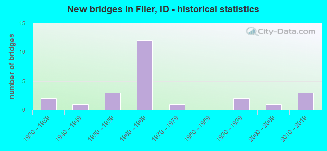
- New bridges - historical statistics
- 21930-1939
- 11940-1949
- 31950-1959
- 121960-1969
- 11970-1979
- 21990-1999
- 12000-2009
- 32010-2019

- Reconstructed bridges - Historical Statistics
- 31960-1969
- 01970-1979
- 01980-1989
- 01990-1999
- 02000-2009
- 12010-2019


- Bridge Condition - Deck
- 41.7%Good
- 50.0%Satisfactory
- 8.3%Fair

- Bridge Condition - Superstructure
- 29.2%Good
- 62.5%Satisfactory
- 8.3%Fair

- Bridge Condition - Substructure
- 4.2%Very good
- 8.3%Good
- 66.7%Satisfactory
- 20.8%Fair

- Bridge Condition - Channel
- 34.8%Very good
- 34.8%Good
- 21.7%Satisfactory
- 8.7%Fair
Find on map >> Show street view
Structure Number: 13618, Location: 1.1 W. FILER (Lat: 42.572472, Lng: -114.631417), Route carried "on" structure: US 30, Year Built: 2002, Status: Open, Structure Length: 2.44m (8.01ft), Average Daily Traffic: 5,500 (year 2019), Truck Traffic: 7%, Average Future Daily Traffic: 8,250 (year 2039), Design Load: HL 93, Features Intersected: CEDAR CREEK DRAW
Minimum Vertical Clearance: 30+ m (98+ ft), Kilometerpoint: 336.214, Lanes on structure: 2, Base Highway Network: Yes (Inventory Route: US0, Subroute: 1), Owner: State Highway Agency, Approaching Roadway Width: 11.0m (36.1ft), Skew: 3 degrees, Material/Design: Prestressed concrete, Design/Construction: Stringer/Multi-beam, Number Of Spans In Main Unit: 1, Length of Maximum Span: 23.5m (77.1ft), Curb-To-Curb Width: 12.0m (39.4ft), Out-to-Out Width: 12.8m (42.0ft)
Condition: Deck: Good, Superstructure: Good, Substructure: Good, Channel: Very good, Operating Rating: 69.9 metric tons, Method Used To Determine Operating Rating: Load Factor (LF), Inventory Rating: 36.3 metric tons, Method Used To Determine Inventory Rating: Load Factor (LF), Structural Evaluation: Better than present minimum criteria, Deck Geometry: Somewhat better than minimum adequacy, Waterway Adequacy: Superior to present desirable criteria, Approach Roadway Alignment: Equal to present desirable criteria, Designated Inspection Frequency: Every 48 months, Inspection Date: March 2020, Deck Structure Type: Concrete Cast-file-Place, Wearing Surface/Protective System: Wearing Surface: Monolithic Concrete, Deck Protection: Epoxy Coated Reinforcing
Find on map >> Show street view
Structure Number: 13621, Location: 0.7 E. FILER (Lat: 42.563750, Lng: -114.589250), Route carried "on" structure: US 30, Year Built: 1996, Status: Open, Structure Length: 0.70m (2.30ft), Average Daily Traffic: 10,000 (year 2019), Truck Traffic: 4%, Average Future Daily Traffic: 15,000 (year 2039), Design Load: HS 25 or greater, Features Intersected: 'S' COULEE CANAL
Minimum Vertical Clearance: 30+ m (98+ ft), Kilometerpoint: 340.116, Lanes on structure: 5, Base Highway Network: Yes (Inventory Route: US0, Subroute: 1), Owner: State Highway Agency, Approaching Roadway Width: 23.8m (78.1ft), Skew: 3 degrees, Material/Design: Concrete, Design/Construction: Frame, Number Of Spans In Main Unit: 1, Length of Maximum Span: 6.4m (21.0ft), Curb or Sidewalk Widths: Left: 0.3m (1.0ft), Right: 0.3m (1.0ft), Curb-To-Curb Width: 37.8m (124.0ft), Out-to-Out Width: 38.4m (126.0ft)
Condition: Deck: Good, Superstructure: Good, Substructure: Satisfactory, Channel: Good, Operating Rating: 90.6 metric tons, Method Used To Determine Operating Rating: Load Factor (LF), Inventory Rating: 56.2 metric tons, Method Used To Determine Inventory Rating: Load Factor (LF), Structural Evaluation: Equal to present minimum criteria, Deck Geometry: Superior to present desirable criteria, Waterway Adequacy: Equal to present desirable criteria, Approach Roadway Alignment: Equal to present desirable criteria, Designated Inspection Frequency: Every 48 months, Inspection Date: March 2020, Deck Structure Type: Concrete Cast-file-Place, Wearing Surface/Protective System: Wearing Surface: Bituminous
Find on map >> Show street view
Structure Number: 1757, Location: 37.6 N. NEVADA LINE (Lat: 42.505694, Lng: -114.574778), Route carried "on" structure: US 93, Year Built: 1956, Status: Open, Structure Length: 2.39m (7.84ft), Average Daily Traffic: 5,800 (year 2019), Truck Traffic: 24%, Average Future Daily Traffic: 8,700 (year 2039), Design Load: HS 20, Features Intersected: HIGH LINE CANAL
Minimum Vertical Clearance: 30+ m (98+ ft), Kilometerpoint: 60.341, Lanes on structure: 2, Base Highway Network: Yes (Inventory Route: US0, Subroute: 1), Owner: State Highway Agency, Approaching Roadway Width: 10.4m (34.1ft), Skew: 3 degrees, Material/Design: Steel, Design/Construction: Stringer/Multi-beam, Number Of Spans In Main Unit: 1, Length of Maximum Span: 22.9m (75.1ft), Curb-To-Curb Width: 10.4m (34.1ft), Out-to-Out Width: 11.1m (36.4ft)
Condition: Deck: Satisfactory, Superstructure: Satisfactory, Substructure: Satisfactory, Channel: Very good, Operating Rating: 49.9 metric tons, Method Used To Determine Operating Rating: Load Factor (LF), Inventory Rating: 29.0 metric tons, Method Used To Determine Inventory Rating: Load Factor (LF), Structural Evaluation: Equal to present minimum criteria, Deck Geometry: Meets minimum limits, Waterway Adequacy: Superior to present desirable criteria, Approach Roadway Alignment: Equal to present desirable criteria, Designated Inspection Frequency: Every 24 months, Inspection Date: November 2021, Deck Structure Type: Concrete Cast-file-Place, Wearing Surface/Protective System: Wearing Surface: Bituminous
Find on map >> Show street view
Structure Number: 17576, Location: 39.7 N. NEVADA LINE (Lat: 42.535889, Lng: -114.574694), Route carried "on" structure: US 93, Year Built: 1994, Status: Open, Structure Length: 3.23m (10.60ft), Average Daily Traffic: 5,100 (year 2019), Truck Traffic: 20%, Average Future Daily Traffic: 7,650 (year 2039), Design Load: HS 25 or greater, Features Intersected: LOW LINE CANAL
Minimum Vertical Clearance: 30+ m (98+ ft), Kilometerpoint: 63.693, Lanes on structure: 3, Base Highway Network: Yes (Inventory Route: US0, Subroute: 1), Owner: State Highway Agency, Approaching Roadway Width: 16.5m (54.1ft), Skew: 4 degrees, Material/Design: Prestressed concrete, Design/Construction: Stringer/Multi-beam, Number Of Spans In Main Unit: 1, Length of Maximum Span: 30.5m (100.1ft), Curb-To-Curb Width: 17.3m (56.8ft), Out-to-Out Width: 18.1m (59.4ft)
Condition: Deck: Good, Superstructure: Good, Substructure: Satisfactory, Channel: Very good, Operating Rating: 77.1 metric tons, Method Used To Determine Operating Rating: Load Factor (LF), Inventory Rating: 47.2 metric tons, Method Used To Determine Inventory Rating: Load Factor (LF), Structural Evaluation: Equal to present minimum criteria, Deck Geometry: Superior to present desirable criteria, Waterway Adequacy: Equal to present desirable criteria, Approach Roadway Alignment: Equal to present desirable criteria, Designated Inspection Frequency: Every 48 months, Inspection Date: Febuary 2020, Deck Structure Type: Concrete Cast-file-Place, Wearing Surface/Protective System: Wearing Surface: Monolithic Concrete, Deck Protection: Epoxy Coated Reinforcing
Find on map >> Show street view
Structure Number: 1936, Location: 2S/2.5E FILER;3700N-2450E (Lat: 42.534778, Lng: -114.567889), Route carried "on" structure: County highway 2713, Year Built: 1953, Status: Open, Structure Length: 3.20m (10.50ft), Average Daily Traffic: 1,400 (year 2019), Truck Traffic: 21%, Average Future Daily Traffic: 2,100 (year 2039), Design Load: H 15, Features Intersected: LOW LINE CANAL
Minimum Vertical Clearance: 30+ m (98+ ft), Kilometerpoint: 34.157, Lanes on structure: 2, Owner: Local Agency, Approaching Roadway Width: 8.2m (26.9ft), Skew: 4 degrees, Material/Design: Prestressed concrete, Design/Construction: Tee Beam, Number Of Spans In Main Unit: 2, Length of Maximum Span: 15.2m (49.9ft), Curb-To-Curb Width: 10.4m (34.1ft), Out-to-Out Width: 11.3m (37.1ft)
Condition: Deck: Satisfactory, Superstructure: Fair, Substructure: Satisfactory, Channel: Good, Operating Rating: 27.2 metric tons, Method Used To Determine Operating Rating: Field evaluation and documented engineering judgment, Inventory Rating: 16.3 metric tons, Method Used To Determine Inventory Rating: Field evaluation and documented engineering judgment, Structural Evaluation: Meets minimum limits, Deck Geometry: Equal to present minimum criteria, Waterway Adequacy: Superior to present desirable criteria, Approach Roadway Alignment: Better than present minimum criteria, Length Of Structure Improvement: 4.08m (13.39ft), Designated Inspection Frequency: Every 24 months, Inspection Date: Febuary 2021, Bridge Improvement Cost: $929,000, Roadway Improvement Cost: $93,000, Total Project Cost: $1,394,000 ( Estimate for 2019), Deck Structure Type: Concrete Cast-file-Place, Wearing Surface/Protective System: Wearing Surface: Bituminous
Find on map >> Show street view
Structure Number: 19375, Location: 2.0 N. 0.8 W. FILER (Lat: 42.593556, Lng: -114.631500), Route carried "on" structure: County highway 2715, Year Built: 1932, Year Reconstructed: 2019, Status: Open, Structure Length: 1.04m (3.41ft), Average Daily Traffic: 3,100 (year 2019), Truck Traffic: 6%, Average Future Daily Traffic: 4,650 (year 2039), Design Load: H 15, Features Intersected: CEDAR DRAW
Minimum Vertical Clearance: 30+ m (98+ ft), Kilometerpoint: 6.180, Lanes on structure: 2, Owner: Local Agency, Approaching Roadway Width: 8.4m (27.6ft), Material/Design: Concrete, Design/Construction: Stringer/Multi-beam, Number Of Spans In Main Unit: 1, Length of Maximum Span: 9.8m (32.2ft), Curb-To-Curb Width: 10.6m (34.8ft), Out-to-Out Width: 11.5m (37.7ft)
Condition: Deck: Satisfactory, Superstructure: Satisfactory, Substructure: Satisfactory, Channel: Good, Operating Rating: 40.8 metric tons, Method Used To Determine Operating Rating: Load Factor (LF), Inventory Rating: 24.5 metric tons, Method Used To Determine Inventory Rating: Load Factor (LF), Structural Evaluation: Equal to present minimum criteria, Deck Geometry: Somewhat better than minimum adequacy, Waterway Adequacy: Equal to present minimum criteria, Approach Roadway Alignment: Equal to present desirable criteria, Length Of Structure Improvement: 1.68m (5.51ft), Designated Inspection Frequency: Every 24 months, Inspection Date: Febuary 2021, Bridge Improvement Cost: $399,000, Roadway Improvement Cost: $40,000, Total Project Cost: $599,000 ( Estimate for 2017), Deck Structure Type: Concrete Cast-file-Place, Wearing Surface/Protective System: Wearing Surface: Bituminous
Find on map >> Show street view
Structure Number: 1938, Location: 1.8 S. FILER;3725N-2200E (Lat: 42.540278, Lng: -114.614167), Route carried "on" structure: County highway 2721, Year Built: 1964, Status: Posted for load, Structure Length: 2.65m (8.69ft), Average Daily Traffic: 690 (year 2019), Truck Traffic: 13%, Average Future Daily Traffic: 1,035 (year 2039), Design Load: H 15, Features Intersected: LOW LINE CANAL
Minimum Vertical Clearance: 30+ m (98+ ft), Kilometerpoint: 0.600, Lanes on structure: 2, Owner: Local Agency, Approaching Roadway Width: 9.1m (29.9ft), Skew: 4 degrees, Material/Design: Prestressed concrete, Design/Construction: Stringer/Multi-beam, Number Of Spans In Main Unit: 2, Length of Maximum Span: 13.1m (43.0ft), Curb-To-Curb Width: 8.2m (26.9ft), Out-to-Out Width: 8.4m (27.6ft)
Condition: Deck: Satisfactory, Superstructure: Satisfactory, Substructure: Satisfactory, Channel: Good, Operating Rating: 34.5 metric tons, Method Used To Determine Operating Rating: Field evaluation and documented engineering judgment, Inventory Rating: 20.9 metric tons, Method Used To Determine Inventory Rating: Field evaluation and documented engineering judgment, Structural Evaluation: Somewhat better than minimum adequacy, Deck Geometry: Somewhat better than minimum adequacy, Waterway Adequacy: Equal to present desirable criteria, Approach Roadway Alignment: Equal to present minimum criteria, Bridge Posting: Required (Relationship of Operating Rating to Maximum Legal Load: 20.0 - 29.9% below), Length Of Structure Improvement: 3.47m (11.38ft), Designated Inspection Frequency: Every 24 months, Inspection Date: Febuary 2020, Bridge Improvement Cost: $640,000, Roadway Improvement Cost: $64,000, Total Project Cost: $959,000 ( Estimate for 2018), Deck Structure Type: Concrete Precast Panels, Wearing Surface/Protective System: Wearing Surface: Bituminous
Find on map >> Show street view
Structure Number: 19385, Location: 1.3 S. FILER;3765N-2200E (Lat: 42.543444, Lng: -114.614056), Route carried "on" structure: County highway 2721, Year Built: 1964, Status: Open, Structure Length: 0.94m (3.08ft), Average Daily Traffic: 690 (year 2019), Truck Traffic: 13%, Average Future Daily Traffic: 1,035 (year 2039), Design Load: H 15, Features Intersected: CEDAR DRAW
Minimum Vertical Clearance: 30+ m (98+ ft), Kilometerpoint: 0.965, Lanes on structure: 2, Owner: Local Agency, Approaching Roadway Width: 7.3m (24.0ft), Material/Design: Concrete, Design/Construction: Arch - Deck, Number Of Spans In Main Unit: 1, Length of Maximum Span: 7.9m (25.9ft), Curb-To-Curb Width: 7.9m (25.9ft), Out-to-Out Width: 8.1m (26.6ft)
Condition: Deck: Satisfactory, Superstructure: Satisfactory, Substructure: Satisfactory, Channel: Satisfactory, Operating Rating: 78.9 metric tons, Method Used To Determine Operating Rating: Load and Resistance Factor (LRFR), Inventory Rating: 60.8 metric tons, Method Used To Determine Inventory Rating: Load and Resistance Factor (LRFR), Structural Evaluation: Equal to present minimum criteria, Deck Geometry: Somewhat better than minimum adequacy, Waterway Adequacy: Superior to present desirable criteria, Approach Roadway Alignment: Better than present minimum criteria, Length Of Structure Improvement: 1.58m (5.18ft), Designated Inspection Frequency: Every 24 months, Inspection Date: Febuary 2021, Bridge Improvement Cost: $292,000, Roadway Improvement Cost: $29,000, Total Project Cost: $438,000 ( Estimate for 2017), Wearing Surface/Protective System: Wearing Surface: Bituminous
Find on map >> Show street view
Structure Number: 19388, Location: 4.7 W. TWIN FALLS WCL (Lat: 42.593028, Lng: -114.571722), Route carried "on" structure: Ramp US 93, Year Built: 2011, Status: Open, Structure Length: 8.17m (26.80ft), Average Daily Traffic: 4,800 (year 2019), Truck Traffic: 10%, Average Future Daily Traffic: 7,200 (year 2039), Design Load: HL 93, Features Intersected: US 93
Minimum Vertical Clearance: 30+ m (98+ ft), Kilometerpoint: 161.140, Lanes on structure: 1, Lanes under structure: 4, Base Highway Network: Yes, Owner: State Highway Agency, Approaching Roadway Width: 8.5m (27.9ft), Material/Design: Prestressed concrete continuous, Design/Construction: Box Beam or Girders - Single/Spread, Number Of Spans In Main Unit: 2, Length of Maximum Span: 40.0m (131.2ft), Curb-To-Curb Width: 8.8m (28.9ft), Out-to-Out Width: 9.6m (31.5ft)
Condition: Deck: Good, Superstructure: Good, Substructure: Very good, Operating Rating: 61.9 metric tons, Method Used To Determine Operating Rating: Load and Resistance Factor Rating (LRFR) rating reported by rating factor(RF) method using HL-93 loadings, Inventory Rating: 34.0 metric tons, Method Used To Determine Inventory Rating: Load and Resistance Factor Rating (LRFR) rating reported by rating factor(RF) method using HL-93 loadings, Structural Evaluation: Better than present minimum criteria, Deck Geometry: Superior to present desirable criteria, Underclear: Equal to present minimum criteria, Approach Roadway Alignment: Equal to present desirable criteria, Designated Inspection Frequency: Every 48 months, Inspection Date: August 2019, Deck Structure Type: Concrete Cast-file-Place, Wearing Surface/Protective System: Wearing Surface: Latex Concrete, Deck Protection: Epoxy Coated Reinforcing
Find on map >> Show street view
Structure Number: 2541, Location: 3.4 S. FILER;JORDON COR (Lat: 42.513861, Lng: -114.614333), Route carried "on" structure: County highway , Year Built: 1968, Status: Open, Structure Length: 2.47m (8.10ft), Average Daily Traffic: 350 (year 2019), Truck Traffic: 10%, Average Future Daily Traffic: 525 (year 2039), Design Load: H 15, Features Intersected: HIGH LINE CANAL, Facility Carried by Structure: 2200 EAST RD
Minimum Vertical Clearance: 30+ m (98+ ft), Kilometerpoint: 168.271, Lanes on structure: 2, Owner: Local Agency, Approaching Roadway Width: 8.5m (27.9ft), Skew: 4 degrees, Material/Design: Prestressed concrete, Design/Construction: Channel Beam, Number Of Spans In Main Unit: 2, Length of Maximum Span: 12.5m (41.0ft), Curb-To-Curb Width: 10.3m (33.8ft), Out-to-Out Width: 10.5m (34.4ft)
Condition: Deck: Satisfactory, Superstructure: Satisfactory, Substructure: Fair, Channel: Good, Operating Rating: 27.2 metric tons, Method Used To Determine Operating Rating: Field evaluation and documented engineering judgment, Inventory Rating: 16.3 metric tons, Method Used To Determine Inventory Rating: Field evaluation and documented engineering judgment, Structural Evaluation: Somewhat better than minimum adequacy, Deck Geometry: Better than present minimum criteria, Waterway Adequacy: Equal to present desirable criteria, Approach Roadway Alignment: Somewhat better than minimum adequacy, Length Of Structure Improvement: 3.26m (10.70ft), Designated Inspection Frequency: Every 24 months, Inspection Date: Febuary 2021, Bridge Improvement Cost: $530,000, Roadway Improvement Cost: $53,000, Total Project Cost: $794,000 ( Estimate for 2019), Deck Structure Type: Concrete Precast Panels, Wearing Surface/Protective System: Wearing Surface: Bituminous
Find on map >> Show street view
Structure Number: 25415, Location: 3.0S 0.7E FILER;JRDN COR (Lat: 42.520250, Lng: -114.596417), Route carried "on" structure: County highway , Year Built: 1963, Status: Open, Structure Length: 0.73m (2.40ft), Average Daily Traffic: 350 (year 2019), Truck Traffic: 10%, Average Future Daily Traffic: 525 (year 2039), Design Load: HS 20, Features Intersected: CEDAR DRAW, Facility Carried by Structure: 3600 NORTH RD
Minimum Vertical Clearance: 30+ m (98+ ft), Kilometerpoint: 163.956, Lanes on structure: 2, Owner: Local Agency, Approaching Roadway Width: 6.7m (22.0ft), Material/Design: Steel, Design/Construction: Stringer/Multi-beam, Number Of Spans In Main Unit: 1, Length of Maximum Span: 7.0m (23.0ft), Curb-To-Curb Width: 6.6m (21.7ft), Out-to-Out Width: 7.1m (23.3ft)
Condition: Deck: Fair, Superstructure: Satisfactory, Substructure: Fair, Channel: Satisfactory, Operating Rating: 49.9 metric tons, Method Used To Determine Operating Rating: Load Factor (LF), Inventory Rating: 29.9 metric tons, Method Used To Determine Inventory Rating: Load Factor (LF), Structural Evaluation: Somewhat better than minimum adequacy, Deck Geometry: Meets minimum limits, Waterway Adequacy: Equal to present desirable criteria, Approach Roadway Alignment: Equal to present desirable criteria, Length Of Structure Improvement: 1.28m (4.20ft), Designated Inspection Frequency: Every 24 months, Inspection Date: Febuary 2021, Bridge Improvement Cost: $208,000, Roadway Improvement Cost: $21,000, Total Project Cost: $312,000 ( Estimate for 2017), Deck Structure Type: Concrete Cast-file-Place, Wearing Surface/Protective System: Wearing Surface: Bituminous
Find on map >> Show street view
Structure Number: 25435, Location: 1.0S 0.3W FILER;JRDN COR (Lat: 42.549444, Lng: -114.618611), Route carried "on" structure: County highway , Year Built: 1968, Status: Posted for load, Structure Length: 0.88m (2.89ft), Average Daily Traffic: 100 (year 2019), Truck Traffic: 10%, Average Future Daily Traffic: 150 (year 2039), Design Load: H 15, Features Intersected: CEDAR DRAW, Facility Carried by Structure: 3800 NORTH ROAD
Minimum Vertical Clearance: 30+ m (98+ ft), Kilometerpoint: 163.799, Lanes on structure: 2, Owner: Local Agency, Approaching Roadway Width: 7.9m (25.9ft), Material/Design: Prestressed concrete, Design/Construction: Channel Beam, Number Of Spans In Main Unit: 1, Length of Maximum Span: 8.5m (27.9ft), Curb-To-Curb Width: 7.8m (25.6ft), Out-to-Out Width: 8.3m (27.2ft)
Condition: Deck: Satisfactory, Superstructure: Satisfactory, Substructure: Satisfactory, Channel: Fair, Operating Rating: 34.5 metric tons, Method Used To Determine Operating Rating: Field evaluation and documented engineering judgment, Inventory Rating: 20.9 metric tons, Method Used To Determine Inventory Rating: Field evaluation and documented engineering judgment, Structural Evaluation: Equal to present minimum criteria, Deck Geometry: Equal to present minimum criteria, Waterway Adequacy: Superior to present desirable criteria, Approach Roadway Alignment: Equal to present desirable criteria, Bridge Posting: Required (Relationship of Operating Rating to Maximum Legal Load: 10.0 - 19.9% below), Designated Inspection Frequency: Every 24 months, Inspection Date: Febuary 2020, Deck Structure Type: Concrete Precast Panels, Wearing Surface/Protective System: Wearing Surface: Bituminous
Find on map >> Show street view
Structure Number: 2545, Location: 1.1S 1.0W FILER;JRDN COR (Lat: 42.545806, Lng: -114.633472), Route carried "on" structure: County highway , Year Built: 1968, Status: Open, Structure Length: 2.38m (7.81ft), Average Daily Traffic: 150 (year 2019), Truck Traffic: 10%, Average Future Daily Traffic: 225 (year 2039), Design Load: H 15, Features Intersected: LOW LINE CANAL, Facility Carried by Structure: 2100 EAST RD
Minimum Vertical Clearance: 30+ m (98+ ft), Kilometerpoint: 168.574, Lanes on structure: 2, Owner: Local Agency, Approaching Roadway Width: 8.5m (27.9ft), Skew: 3 degrees, Material/Design: Prestressed concrete, Design/Construction: Tee Beam, Number Of Spans In Main Unit: 1, Length of Maximum Span: 22.6m (74.1ft), Curb-To-Curb Width: 7.8m (25.6ft), Out-to-Out Width: 8.0m (26.2ft)
Condition: Deck: Good, Superstructure: Satisfactory, Substructure: Satisfactory, Channel: Very good, Operating Rating: 34.5 metric tons, Method Used To Determine Operating Rating: Field evaluation and documented engineering judgment, Inventory Rating: 20.9 metric tons, Method Used To Determine Inventory Rating: Field evaluation and documented engineering judgment, Structural Evaluation: Equal to present minimum criteria, Deck Geometry: Somewhat better than minimum adequacy, Waterway Adequacy: Equal to present desirable criteria, Approach Roadway Alignment: Equal to present desirable criteria, Length Of Structure Improvement: 3.17m (10.40ft), Designated Inspection Frequency: Every 24 months, Inspection Date: Febuary 2021, Bridge Improvement Cost: $480,000, Roadway Improvement Cost: $48,000, Total Project Cost: $721,000 ( Estimate for 2017), Deck Structure Type: Concrete Cast-file-Place, Wearing Surface/Protective System: Wearing Surface: Bituminous
Find on map >> Show street view
Structure Number: 25465, Location: 0.5 W. FILER;JORDEN COR (Lat: 42.563889, Lng: -114.624306), Route carried "on" structure: County highway , Year Built: 1940, Year Reconstructed: 1965, Status: Open, Structure Length: 1.10m (3.61ft), Average Daily Traffic: 1,000 (year 2019), Truck Traffic: 8%, Average Future Daily Traffic: 1,500 (year 2039), Design Load: H 15, Features Intersected: CEDAR DRAW, Facility Carried by Structure: CLOVER ROAD
Minimum Vertical Clearance: 30+ m (98+ ft), Kilometerpoint: 168.312, Lanes on structure: 2, Owner: Local Agency, Approaching Roadway Width: 8.5m (27.9ft), Material/Design: Prestressed concrete, Design/Construction: Stringer/Multi-beam, Number Of Spans In Main Unit: 1, Length of Maximum Span: 9.1m (29.9ft), Curb-To-Curb Width: 8.1m (26.6ft), Out-to-Out Width: 8.3m (27.2ft)
Condition: Deck: Satisfactory, Superstructure: Satisfactory, Substructure: Fair, Channel: Satisfactory, Operating Rating: 27.2 metric tons, Method Used To Determine Operating Rating: Field evaluation and documented engineering judgment, Inventory Rating: 16.3 metric tons, Method Used To Determine Inventory Rating: Field evaluation and documented engineering judgment, Structural Evaluation: Meets minimum limits, Deck Geometry: Somewhat better than minimum adequacy, Waterway Adequacy: Equal to present desirable criteria, Approach Roadway Alignment: Equal to present desirable criteria, Length Of Structure Improvement: 1.77m (5.81ft), Designated Inspection Frequency: Every 24 months, Inspection Date: Febuary 2021, Bridge Improvement Cost: $326,000, Roadway Improvement Cost: $33,000, Total Project Cost: $489,000 ( Estimate for 2017), Deck Structure Type: Concrete Precast Panels, Wearing Surface/Protective System: Wearing Surface: Bituminous
Find on map >> Show street view
Structure Number: 25495, Location: 1.0S 2.0W FILER;JRDN COR (Lat: 42.550667, Lng: -114.653167), Route carried "on" structure: County highway , Year Built: 1965, Status: Open, Structure Length: 1.58m (5.18ft), Average Daily Traffic: 330 (year 2019), Truck Traffic: 10%, Average Future Daily Traffic: 495 (year 2039), Design Load: H 15, Features Intersected: LOW LINE CANAL, Facility Carried by Structure: 2000 EAST ROAD
Minimum Vertical Clearance: 30+ m (98+ ft), Kilometerpoint: 165.914, Lanes on structure: 2, Owner: Local Agency, Approaching Roadway Width: 8.5m (27.9ft), Skew: 1 degrees, Material/Design: Prestressed concrete, Design/Construction: Channel Beam, Number Of Spans In Main Unit: 1, Length of Maximum Span: 15.5m (50.9ft), Curb-To-Curb Width: 8.9m (29.2ft), Out-to-Out Width: 9.2m (30.2ft)
Condition: Deck: Good, Superstructure: Good, Substructure: Satisfactory, Channel: Very good, Operating Rating: 30.6 metric tons, Method Used To Determine Operating Rating: Allowable Stress (AS), Inventory Rating: 22.5 metric tons, Method Used To Determine Inventory Rating: Allowable Stress (AS), Structural Evaluation: Equal to present minimum criteria, Deck Geometry: Equal to present minimum criteria, Waterway Adequacy: Superior to present desirable criteria, Approach Roadway Alignment: Better than present minimum criteria, Designated Inspection Frequency: Every 48 months, Inspection Date: Febuary 2021, Deck Structure Type: Concrete Precast Panels, Wearing Surface/Protective System: Wearing Surface: Bituminous
Find on map >> Show street view
Structure Number: 2551, Location: 1.0S 3.0W FILER;JRDN.COR (Lat: 42.549444, Lng: -114.672778), Route carried "on" structure: County highway , Year Built: 1953, Year Reconstructed: 1968, Status: Open, Structure Length: 1.46m (4.79ft), Average Daily Traffic: 350 (year 2019), Truck Traffic: 11%, Average Future Daily Traffic: 525 (year 2039), Design Load: H 15, Features Intersected: LOW LINE CANAL, Facility Carried by Structure: 1900 EAST ROAD
Minimum Vertical Clearance: 30+ m (98+ ft), Kilometerpoint: 200.087, Lanes on structure: 2, Owner: Local Agency, Approaching Roadway Width: 9.8m (32.2ft), Skew: 1 degrees, Material/Design: Prestressed concrete, Design/Construction: Channel Beam, Number Of Spans In Main Unit: 1, Length of Maximum Span: 14.0m (45.9ft), Curb-To-Curb Width: 9.0m (29.5ft), Out-to-Out Width: 9.2m (30.2ft)
Condition: Deck: Good, Superstructure: Good, Substructure: Satisfactory, Channel: Good, Operating Rating: 34.5 metric tons, Method Used To Determine Operating Rating: Field evaluation and documented engineering judgment, Inventory Rating: 20.9 metric tons, Method Used To Determine Inventory Rating: Field evaluation and documented engineering judgment, Structural Evaluation: Equal to present minimum criteria, Deck Geometry: Equal to present minimum criteria, Waterway Adequacy: Better than present minimum criteria, Approach Roadway Alignment: Better than present minimum criteria, Length Of Structure Improvement: 2.19m (7.19ft), Designated Inspection Frequency: Every 24 months, Inspection Date: Febuary 2021, Bridge Improvement Cost: $404,000, Roadway Improvement Cost: $40,000, Total Project Cost: $606,000 ( Estimate for 2017), Deck Structure Type: Concrete Precast Panels, Wearing Surface/Protective System: Wearing Surface: Bituminous
Find on map >> Show street view
Structure Number: 25535, Location: 2.5 S. 2.7 E. FILER (Lat: 42.533056, Lng: -114.555278), Route carried "on" structure: County highway , Year Built: 1930, Year Reconstructed: 1973, Status: Open, Structure Length: 2.41m (7.91ft), Average Daily Traffic: 140 (year 2019), Truck Traffic: 10%, Average Future Daily Traffic: 210 (year 2039), Design Load: HS 20, Features Intersected: LOW LINE CANAL, Facility Carried by Structure: 2500 EAST ROAD
Minimum Vertical Clearance: 30+ m (98+ ft), Kilometerpoint: 170.411, Lanes on structure: 2, Owner: Local Agency, Approaching Roadway Width: 8.5m (27.9ft), Material/Design: Prestressed concrete, Design/Construction: Tee Beam, Number Of Spans In Main Unit: 2, Length of Maximum Span: 11.9m (39.0ft), Curb or Sidewalk Widths: Left: 0.2m (0.7ft), Right: 0.2m (0.7ft), Curb-To-Curb Width: 7.9m (25.9ft), Out-to-Out Width: 8.5m (27.9ft)
Condition: Deck: Satisfactory, Superstructure: Satisfactory, Substructure: Satisfactory, Channel: Good, Operating Rating: 34.5 metric tons, Method Used To Determine Operating Rating: Field evaluation and documented engineering judgment, Inventory Rating: 20.9 metric tons, Method Used To Determine Inventory Rating: Field evaluation and documented engineering judgment, Structural Evaluation: Equal to present minimum criteria, Deck Geometry: Somewhat better than minimum adequacy, Waterway Adequacy: Equal to present desirable criteria, Approach Roadway Alignment: Better than present minimum criteria, Designated Inspection Frequency: Every 24 months, Inspection Date: Febuary 2020, Deck Structure Type: Concrete Cast-file-Place, Wearing Surface/Protective System: Wearing Surface: Bituminous
Find on map >> Show street view
Structure Number: 2556, Location: 3.4S 2.0W FILER;JRDN COR (Lat: 42.513611, Lng: -114.653056), Route carried "on" structure: County highway , Year Built: 1965, Status: Open, Structure Length: 1.43m (4.69ft), Average Daily Traffic: 400 (year 2019), Truck Traffic: 10%, Average Future Daily Traffic: 600 (year 2039), Design Load: H 15, Features Intersected: HIGH LINE CANAL, Facility Carried by Structure: 2000 EAST ROAD
Minimum Vertical Clearance: 30+ m (98+ ft), Kilometerpoint: 161.805, Lanes on structure: 2, Owner: Local Agency, Approaching Roadway Width: 8.5m (27.9ft), Skew: 1 degrees, Material/Design: Prestressed concrete, Design/Construction: Channel Beam, Number Of Spans In Main Unit: 1, Length of Maximum Span: 13.7m (44.9ft), Curb-To-Curb Width: 7.8m (25.6ft), Out-to-Out Width: 8.2m (26.9ft)
Condition: Deck: Satisfactory, Superstructure: Satisfactory, Substructure: Fair, Channel: Fair, Operating Rating: 27.2 metric tons, Method Used To Determine Operating Rating: Field evaluation and documented engineering judgment, Inventory Rating: 16.3 metric tons, Method Used To Determine Inventory Rating: Field evaluation and documented engineering judgment, Structural Evaluation: Somewhat better than minimum adequacy, Deck Geometry: Somewhat better than minimum adequacy, Waterway Adequacy: Equal to present desirable criteria, Approach Roadway Alignment: Better than present minimum criteria, Length Of Structure Improvement: 2.16m (7.09ft), Designated Inspection Frequency: Every 24 months, Inspection Date: Febuary 2020, Bridge Improvement Cost: $398,000, Roadway Improvement Cost: $40,000, Total Project Cost: $597,000 ( Estimate for 2018), Deck Structure Type: Concrete Precast Panels, Wearing Surface/Protective System: Wearing Surface: Bituminous
Find on map >> Show street view
Structure Number: 25565, Location: 0.5N 0.9W FILER;JRDN COR (Lat: 42.571167, Lng: -114.631472), Route carried "on" structure: County highway , Year Built: 1968, Status: Open, Structure Length: 0.88m (2.89ft), Average Daily Traffic: 300 (year 2019), Truck Traffic: 10%, Average Future Daily Traffic: 450 (year 2039), Design Load: H 15, Features Intersected: CEDAR DRAW, Facility Carried by Structure: 3950 NORTH RD
Minimum Vertical Clearance: 30+ m (98+ ft), Kilometerpoint: 164.341, Lanes on structure: 2, Owner: Local Agency, Approaching Roadway Width: 9.1m (29.9ft), Material/Design: Prestressed concrete, Design/Construction: Tee Beam, Number Of Spans In Main Unit: 1, Length of Maximum Span: 8.2m (26.9ft), Curb-To-Curb Width: 7.7m (25.3ft), Out-to-Out Width: 8.3m (27.2ft)
Condition: Deck: Satisfactory, Superstructure: Satisfactory, Substructure: Satisfactory, Channel: Good, Operating Rating: 34.5 metric tons, Method Used To Determine Operating Rating: Field evaluation and documented engineering judgment, Inventory Rating: 20.9 metric tons, Method Used To Determine Inventory Rating: Field evaluation and documented engineering judgment, Structural Evaluation: Equal to present minimum criteria, Deck Geometry: Somewhat better than minimum adequacy, Waterway Adequacy: Equal to present desirable criteria, Approach Roadway Alignment: Better than present minimum criteria, Length Of Structure Improvement: 1.49m (4.89ft), Designated Inspection Frequency: Every 24 months, Inspection Date: Febuary 2021, Bridge Improvement Cost: $243,000, Roadway Improvement Cost: $24,000, Total Project Cost: $363,000 ( Estimate for 2017), Deck Structure Type: Concrete Cast-file-Place, Wearing Surface/Protective System: Wearing Surface: Bituminous
Find on map >> Show street view
Structure Number: 2557, Location: 4.0N 1.9W FILER;JRDN COR (Lat: 42.622556, Lng: -114.653889), Route carried "on" structure: County highway , Year Built: 1968, Status: Open, Structure Length: 1.04m (3.41ft), Average Daily Traffic: 360 (year 2019), Truck Traffic: 22%, Average Future Daily Traffic: 540 (year 2039), Design Load: HS 20, Features Intersected: CEDAR DRAW, Facility Carried by Structure: 4300 NORTH RD
Minimum Vertical Clearance: 30+ m (98+ ft), Kilometerpoint: 198.950, Lanes on structure: 2, Owner: Local Agency, Approaching Roadway Width: 7.9m (25.9ft), Material/Design: Steel, Design/Construction: Stringer/Multi-beam, Number Of Spans In Main Unit: 1, Length of Maximum Span: 8.8m (28.9ft), Curb-To-Curb Width: 6.2m (20.3ft), Out-to-Out Width: 6.7m (22.0ft)
Condition: Deck: Fair, Superstructure: Satisfactory, Substructure: Satisfactory, Channel: Satisfactory, Operating Rating: 60.8 metric tons, Method Used To Determine Operating Rating: Load Factor (LF), Inventory Rating: 36.3 metric tons, Method Used To Determine Inventory Rating: Load Factor (LF), Structural Evaluation: Equal to present minimum criteria, Deck Geometry: Meets minimum limits, Waterway Adequacy: Better than present minimum criteria, Approach Roadway Alignment: Equal to present desirable criteria, Length Of Structure Improvement: 1.65m (5.41ft), Designated Inspection Frequency: Every 24 months, Inspection Date: Febuary 2021, Bridge Improvement Cost: $303,000, Roadway Improvement Cost: $30,000, Total Project Cost: $454,000 ( Estimate for 2017), Deck Structure Type: Concrete Cast-file-Place, Wearing Surface/Protective System: Wearing Surface: Bituminous
Find on map >> Show street view
Structure Number: 2562, Location: 1.8S 1.0E FILER;JRDN COR (Lat: 42.538222, Lng: -114.594389), Route carried "on" structure: County highway , Year Built: 1963, Status: Open, Structure Length: 1.95m (6.40ft), Average Daily Traffic: 400 (year 2019), Truck Traffic: 10%, Average Future Daily Traffic: 600 (year 2039), Design Load: H 15, Features Intersected: LOW LINE CANAL, Facility Carried by Structure: 2300 EAST RD
Minimum Vertical Clearance: 30+ m (98+ ft), Kilometerpoint: 190.318, Lanes on structure: 2, Owner: Local Agency, Approaching Roadway Width: 7.9m (25.9ft), Skew: 1 degrees, Material/Design: Prestressed concrete, Design/Construction: Tee Beam, Number Of Spans In Main Unit: 1, Length of Maximum Span: 19.2m (63.0ft), Curb-To-Curb Width: 8.1m (26.6ft), Out-to-Out Width: 8.7m (28.5ft)
Condition: Deck: Good, Superstructure: Satisfactory, Substructure: Satisfactory, Channel: Very good, Operating Rating: 34.5 metric tons, Method Used To Determine Operating Rating: Field evaluation and documented engineering judgment, Inventory Rating: 20.9 metric tons, Method Used To Determine Inventory Rating: Field evaluation and documented engineering judgment, Structural Evaluation: Equal to present minimum criteria, Deck Geometry: Somewhat better than minimum adequacy, Waterway Adequacy: Equal to present desirable criteria, Approach Roadway Alignment: Better than present minimum criteria, Designated Inspection Frequency: Every 24 months, Inspection Date: Febuary 2021, Deck Structure Type: Concrete Cast-file-Place, Wearing Surface/Protective System: Wearing Surface: Bituminous
Find on map >> Show street view
Structure Number: 25641, Location: 4.3 N. 2.1 W. FILER (Lat: 42.623403, Lng: -114.654394), Route carried "on" structure: County highway , Year Built: 2012, Status: Open, Structure Length: 0.73m (2.40ft), Average Daily Traffic: 230 (year 2019), Average Future Daily Traffic: 345 (year 2039), Design Load: HL 93, Features Intersected: CEDAR DRAW CREEK, Facility Carried by Structure: 2000 EAST ROAD
Minimum Vertical Clearance: 30+ m (98+ ft), Kilometerpoint: 164.246, Lanes on structure: 2, Owner: Local Agency, Approaching Roadway Width: 7.6m (24.9ft), Material/Design: Concrete, Design/Construction: Frame, Number Of Spans In Main Unit: 1, Length of Maximum Span: 7.3m (24.0ft), Curb or Sidewalk Widths: Left: 0.4m (1.3ft), Right: 0.4m (1.3ft), Curb-To-Curb Width: 9.2m (30.2ft), Out-to-Out Width: 11.6m (38.1ft)
Condition: Deck: Good, Superstructure: Good, Substructure: Good, Channel: Very good, Operating Rating: 63.5 metric tons, Method Used To Determine Operating Rating: Load and Resistance Factor Rating (LRFR) rating reported by rating factor(RF) method using HL-93 loadings, Inventory Rating: 48.9 metric tons, Method Used To Determine Inventory Rating: Load and Resistance Factor Rating (LRFR) rating reported by rating factor(RF) method using HL-93 loadings, Structural Evaluation: Better than present minimum criteria, Deck Geometry: Equal to present minimum criteria, Waterway Adequacy: Better than present minimum criteria, Approach Roadway Alignment: Equal to present desirable criteria, Designated Inspection Frequency: Every 48 months, Inspection Date: Febuary 2019, Deck Structure Type: Concrete Cast-file-Place, Wearing Surface/Protective System: Wearing Surface: Bituminous
Find on map >> Show street view
Structure Number: 2565, Location: 1.0S 3.2W FILER;JRDN COR (Lat: 42.549389, Lng: -114.678028), Route carried "on" structure: County highway , Year Built: 1973, Status: Open, Structure Length: 1.43m (4.69ft), Average Daily Traffic: 100 (year 2019), Truck Traffic: 10%, Average Future Daily Traffic: 150 (year 2039), Design Load: H 15, Features Intersected: LOW LINE CANAL, Facility Carried by Structure: 3800 NORTH RD
Minimum Vertical Clearance: 30+ m (98+ ft), Kilometerpoint: 174.992, Lanes on structure: 2, Owner: Local Agency, Approaching Roadway Width: 7.9m (25.9ft), Skew: 1 degrees, Material/Design: Prestressed concrete, Design/Construction: Tee Beam, Number Of Spans In Main Unit: 1, Length of Maximum Span: 13.7m (44.9ft), Curb-To-Curb Width: 7.9m (25.9ft), Out-to-Out Width: 8.5m (27.9ft)
Condition: Deck: Good, Superstructure: Fair, Substructure: Fair, Channel: Satisfactory, Operating Rating: 27.2 metric tons, Method Used To Determine Operating Rating: Field evaluation and documented engineering judgment, Inventory Rating: 16.3 metric tons, Method Used To Determine Inventory Rating: Field evaluation and documented engineering judgment, Structural Evaluation: Somewhat better than minimum adequacy, Deck Geometry: Equal to present minimum criteria, Waterway Adequacy: Equal to present desirable criteria, Approach Roadway Alignment: Better than present minimum criteria, Length Of Structure Improvement: 2.07m (6.79ft), Designated Inspection Frequency: Every 24 months, Inspection Date: Febuary 2021, Bridge Improvement Cost: $314,000, Roadway Improvement Cost: $31,000, Total Project Cost: $471,000 ( Estimate for 2017), Deck Structure Type: Concrete Cast-file-Place, Wearing Surface/Protective System: Wearing Surface: Bituminous
Find on map >> Show street view
Structure Number: 25655, Location: 3.8S 1.0E FILER;JRDN COR (Lat: 42.507442, Lng: -114.594353), Route carried "on" structure: County highway , Year Built: 1963, Status: Open, Structure Length: 2.13m (6.99ft), Average Daily Traffic: 350 (year 2019), Truck Traffic: 10%, Average Future Daily Traffic: 525 (year 2039), Design Load: H 15, Features Intersected: HIGH LINE CANAL, Facility Carried by Structure: 2300 EAST RD
Minimum Vertical Clearance: 30+ m (98+ ft), Kilometerpoint: 186.903, Lanes on structure: 2, Owner: Local Agency, Approaching Roadway Width: 7.3m (24.0ft), Material/Design: Prestressed concrete, Design/Construction: Tee Beam, Number Of Spans In Main Unit: 2, Length of Maximum Span: 11.0m (36.1ft), Curb-To-Curb Width: 8.5m (27.9ft), Out-to-Out Width: 8.8m (28.9ft)
Condition: Deck: Satisfactory, Superstructure: Satisfactory, Substructure: Satisfactory, Channel: Very good, Operating Rating: 27.2 metric tons, Method Used To Determine Operating Rating: Field evaluation and documented engineering judgment, Inventory Rating: 16.3 metric tons, Method Used To Determine Inventory Rating: Field evaluation and documented engineering judgment, Structural Evaluation: Somewhat better than minimum adequacy, Deck Geometry: Equal to present minimum criteria, Waterway Adequacy: Equal to present desirable criteria, Approach Roadway Alignment: Better than present minimum criteria, Length Of Structure Improvement: 2.87m (9.42ft), Designated Inspection Frequency: Every 24 months, Inspection Date: Febuary 2021, Bridge Improvement Cost: $465,000, Roadway Improvement Cost: $47,000, Total Project Cost: $698,000 ( Estimate for 2017), Deck Structure Type: Concrete Precast Panels, Wearing Surface/Protective System: Wearing Surface: Bituminous
Find on map >> Show street view
Structure Number: 19388, Location: 4.7 W. TWIN FALLS WCL (Lat: 42.593028, Lng: -114.571722), Route carried "under" structure: US 93, Year Built: 2011, Structure Length: 0. m, Average Daily Traffic: 5,400 (year 2018), Truck Traffic: 6%, Features Intersected: US 93
Minimum Vertical Clearance: 6.71m (22.01ft), Kilometerpoint: 10.496, Lanes on structure: 1, Lanes under structure: 4, Material/Design: Prestressed concrete continuous, Design/Construction: Box Beam or Girders - Single/Spread, Length of Maximum Span: 40.0m (131.2ft)