Bridge Statistics for Fincastle, Virginia (VA)
Condition, Traffic, Stress, Structural Evaluation, Project Costs
- National Bridge Inventory (NBI) Statistics
- 15Number of bridges
- 459ft / 140mTotal length
- $27,604,000Total costs
- 65,484Total average daily traffic
- 2,631Total average daily truck traffic
- 87,420Total future (year 2040) average daily traffic
- National Bridge Inventory (NBI) Registered Bridges for Fincastle
- No street view available for this location
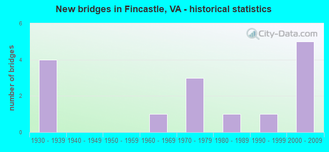
- New bridges - historical statistics
- 41930-1939
- 11960-1969
- 31970-1979
- 11980-1989
- 11990-1999
- 52000-2009


- Bridge Condition - Deck
- 7.7%Excellent
- 23.1%Very good
- 46.2%Good
- 23.1%Satisfactory

- Bridge Condition - Superstructure
- 7.7%Excellent
- 38.5%Very good
- 30.8%Good
- 15.4%Satisfactory
- 7.7%Fair

- Bridge Condition - Substructure
- 7.7%Very good
- 38.5%Good
- 53.8%Satisfactory

- Bridge Condition - Channel
- 35.7%Very good
- 28.6%Good
- 35.7%Satisfactory

- Bridge Condition - Culverts
- 50.0%Very good
- 50.0%Satisfactory
Find on map >> Show street view
Structure Number: 3297, Location: 0.45-Rte681; 1.27-Rte679 (Lat: 37.543203, Lng: -79.861161), Route carried "on" structure: US 220, Year Built: 1980, Status: Open, Structure Length: 0.64m (2.10ft), Average Daily Traffic: 9,165 (year 2020), Truck Traffic: 7%, Average Future Daily Traffic: 10,772 (year 2040), Design Load: HS 20, Features Intersected: Branch of Catawba Creek
Minimum Vertical Clearance: 30+ m (98+ ft), Kilometerpoint: 141.829, Lanes on structure: 4, Base Highway Network: Yes, Owner: State Highway Agency, Approaching Roadway Width: 14.9m (48.9ft), Skew: 20 degrees, Material/Design: Steel, Design/Construction: Culvert, Number Of Spans In Main Unit: 2, Length of Maximum Span: 2.7m (8.9ft)
Condition: Channel: Good, Culverts: Satisfactory, Operating Rating: 89.8 metric tons, Method Used To Determine Operating Rating: Field evaluation and documented engineering judgment, Inventory Rating: 89.8 metric tons, Method Used To Determine Inventory Rating: Field evaluation and documented engineering judgment, Structural Evaluation: Equal to present minimum criteria, Waterway Adequacy: Better than present minimum criteria, Approach Roadway Alignment: Equal to present desirable criteria, Length Of Structure Improvement: 0.64m (2.10ft), Designated Inspection Frequency: Every 24 months, Inspection Date: June 2021, Bridge Improvement Cost: $547,000, Roadway Improvement Cost: $190,000, Total Project Cost: $1,823,000 ( Estimate for 2020)
Find on map >> Show street view
Structure Number: 3303, Location: 1.31-FCASTLE;0.14-RT 655 (Lat: 37.518275, Lng: -79.879569), Route carried "on" structure: State highway 220, Year Built: 1978, Status: Open, Structure Length: 6.52m (21.39ft), Average Daily Traffic: 4,582 (year 2020), Truck Traffic: 7%, Average Future Daily Traffic: 6,416 (year 2040), Design Load: HS 20+Mod, Features Intersected: Catawba Creek, Facility Carried by Structure: Botetourt Road SBL
Minimum Vertical Clearance: 30+ m (98+ ft), Kilometerpoint: 139.066, Lanes on structure: 2, Base Highway Network: Yes, Owner: State Highway Agency, Approaching Roadway Width: 9.1m (29.9ft), Skew: 3 degrees, Material/Design: Steel, Design/Construction: Stringer/Multi-beam, Number Of Spans In Main Unit: 3, Length of Maximum Span: 24.4m (80.1ft), Curb or Sidewalk Widths: Left: 0.5m (1.6ft), Right: 0.5m (1.6ft), Curb-To-Curb Width: 11.7m (38.4ft), Out-to-Out Width: 12.7m (41.7ft)
Condition: Deck: Satisfactory, Superstructure: Satisfactory, Substructure: Satisfactory, Channel: Very good, Operating Rating: 64.4 metric tons, Method Used To Determine Operating Rating: Load and Resistance Factor (LRFR), Inventory Rating: 49.0 metric tons, Method Used To Determine Inventory Rating: Load and Resistance Factor (LRFR), Structural Evaluation: Equal to present minimum criteria, Deck Geometry: Better than present minimum criteria, Waterway Adequacy: Better than present minimum criteria, Approach Roadway Alignment: Equal to present desirable criteria, Length Of Structure Improvement: 6.52m (21.39ft), Designated Inspection Frequency: Every 24 months, Inspection Date: Febuary 2022, Bridge Improvement Cost: $4,408,000, Roadway Improvement Cost: $1,543,000, Total Project Cost: $14,767,000 ( Estimate for 2020), Deck Structure Type: Concrete Cast-file-Place, Wearing Surface/Protective System: Wearing Surface: Epoxy Overlay, Deck Protection: Epoxy Coated Reinforcing
Find on map >> Show street view
Structure Number: 3318, Location: 0.65-Rte668; 1.20-Rte606 (Lat: 37.521694, Lng: -79.894378), Route carried "on" structure: County highway 600, Year Built: 1971, Status: Open, Structure Length: 0.73m (2.40ft), Average Daily Traffic: 85 (year 2019), Average Future Daily Traffic: 121 (year 2040), Features Intersected: Borden Creek
Minimum Vertical Clearance: 30+ m (98+ ft), Kilometerpoint: 24.714, Lanes on structure: 1, Owner: State Highway Agency, Approaching Roadway Width: 3.7m (12.1ft), Skew: 1 degrees, Material/Design: Concrete, Design/Construction: Box Beam or Girders - Multiple, Number Of Spans In Main Unit: 1, Length of Maximum Span: 6.4m (21.0ft), Curb or Sidewalk Widths: Left: 0.1m (0.3ft), Right: 0.1m (0.3ft), Curb-To-Curb Width: 3.8m (12.5ft), Out-to-Out Width: 4.1m (13.5ft)
Condition: Deck: Very good, Superstructure: Very good, Substructure: Good, Channel: Very good, Operating Rating: 74.4 metric tons, Method Used To Determine Operating Rating: Load and Resistance Factor (LRFR), Inventory Rating: 57.2 metric tons, Method Used To Determine Inventory Rating: Load and Resistance Factor (LRFR), Structural Evaluation: Better than present minimum criteria, Deck Geometry: Meets minimum limits, Waterway Adequacy: Equal to present minimum criteria, Approach Roadway Alignment: Equal to present minimum criteria, Length Of Structure Improvement: 0.73m (2.40ft), Designated Inspection Frequency: Every 24 months, Inspection Date: Febuary 2022, Bridge Improvement Cost: $186,000, Roadway Improvement Cost: $28,000, Total Project Cost: $550,000 ( Estimate for 2022), Wearing Surface/Protective System: Wearing Surface: Bituminous
Find on map >> Show street view
Structure Number: 3322, Location: 0.85-Rte606; 0.80-Rte670 (Lat: 37.501581, Lng: -79.912017), Route carried "on" structure: County highway 600, Year Built: 1932, Status: Open, Structure Length: 1.22m (4.00ft), Average Daily Traffic: 174 (year 2016), Average Future Daily Traffic: 195 (year 2040), Design Load: HS 20, Features Intersected: N Fork Catawba Creek
Minimum Vertical Clearance: 30+ m (98+ ft), Kilometerpoint: 21.174, Lanes on structure: 1, Owner: State Highway Agency, Approaching Roadway Width: 4.9m (16.1ft), Material/Design: Prestressed concrete, Design/Construction: Slab, Number Of Spans In Main Unit: 1, Length of Maximum Span: 11.5m (37.7ft), Curb or Sidewalk Widths: Left: 0.1m (0.3ft), Right: 0.1m (0.3ft), Curb-To-Curb Width: 3.7m (12.1ft), Out-to-Out Width: 3.7m (12.1ft)
Condition: Deck: Very good, Superstructure: Very good, Substructure: Satisfactory, Channel: Good, Operating Rating: 62.6 metric tons, Method Used To Determine Operating Rating: Load and Resistance Factor (LRFR), Inventory Rating: 49.0 metric tons, Method Used To Determine Inventory Rating: Load and Resistance Factor (LRFR), Structural Evaluation: Equal to present minimum criteria, Deck Geometry: High priority of replacement, Waterway Adequacy: Equal to present minimum criteria, Approach Roadway Alignment: High priority of corrective action, Length Of Structure Improvement: 1.22m (4.00ft), Designated Inspection Frequency: Every 24 months, Inspection Date: September 2020, Bridge Improvement Cost: $390,000, Roadway Improvement Cost: $97,000, Total Project Cost: $1,247,000 ( Estimate for 2020), Deck Structure Type: Other, Wearing Surface/Protective System: Wearing Surface: Bituminous
Find on map >> Show street view
Structure Number: 3328, Location: 1.95 Rt 600; 0.20 Rt 666 (Lat: 37.529700, Lng: -79.924978), Route carried "on" structure: County highway 606, Year Built: 1932, Year Reconstructed: 1995, Status: Open, Structure Length: 0.79m (2.59ft), Average Daily Traffic: 473 (year 2020), Truck Traffic: 2%, Average Future Daily Traffic: 610 (year 2040), Features Intersected: N. Fork Catawba Creek
Minimum Vertical Clearance: 30+ m (98+ ft), Kilometerpoint: 5.149, Lanes on structure: 2, Owner: State Highway Agency, Approaching Roadway Width: 5.5m (18.0ft), Skew: 4 degrees, Material/Design: Steel, Design/Construction: Stringer/Multi-beam, Number Of Spans In Main Unit: 1, Length of Maximum Span: 7.0m (23.0ft), Curb or Sidewalk Widths: Left: 0.5m (1.6ft), Right: 0.5m (1.6ft), Curb-To-Curb Width: 6.1m (20.0ft), Out-to-Out Width: 7.0m (23.0ft)
Condition: Deck: Good, Superstructure: Good, Substructure: Satisfactory, Channel: Satisfactory, Operating Rating: 59.9 metric tons, Method Used To Determine Operating Rating: Load and Resistance Factor (LRFR), Inventory Rating: 46.3 metric tons, Method Used To Determine Inventory Rating: Load and Resistance Factor (LRFR), Structural Evaluation: Equal to present minimum criteria, Deck Geometry: High priority of corrective action, Waterway Adequacy: Somewhat better than minimum adequacy, Approach Roadway Alignment: High priority of corrective action, Length Of Structure Improvement: 0.79m (2.59ft), Designated Inspection Frequency: Every 24 months, Inspection Date: April 2021, Bridge Improvement Cost: $415,000, Roadway Improvement Cost: $104,000, Total Project Cost: $1,327,000 ( Estimate for 2021), Deck Structure Type: Wood or Timber, Wearing Surface/Protective System: Wearing Surface: Bituminous, Membrane: Preformed Fabric
Find on map >> Show street view
Structure Number: 3329, Location: 0.00-Rte600; 1.45-Rte630 (Lat: 37.507803, Lng: -79.903364), Route carried "on" structure: County highway 606, Year Built: 1970, Status: Open, Structure Length: 2.07m (6.79ft), Average Daily Traffic: 847 (year 2020), Truck Traffic: 2%, Average Future Daily Traffic: 1,173 (year 2040), Design Load: HS 20+Mod, Features Intersected: Catawba Creek
Minimum Vertical Clearance: 30+ m (98+ ft), Kilometerpoint: 8.447, Lanes on structure: 2, Owner: State Highway Agency, Approaching Roadway Width: 6.1m (20.0ft), Material/Design: Concrete, Design/Construction: Frame, Number Of Spans In Main Unit: 3, Length of Maximum Span: 6.9m (22.6ft), Curb-To-Curb Width: 8.2m (26.9ft), Out-to-Out Width: 10.1m (33.1ft)
Condition: Deck: Satisfactory, Superstructure: Satisfactory, Substructure: Satisfactory, Channel: Satisfactory, Operating Rating: 42.6 metric tons, Method Used To Determine Operating Rating: Load Factor (LF), Inventory Rating: 25.4 metric tons, Method Used To Determine Inventory Rating: Load Factor (LF), Structural Evaluation: Equal to present minimum criteria, Deck Geometry: Somewhat better than minimum adequacy, Waterway Adequacy: Equal to present minimum criteria, Approach Roadway Alignment: Equal to present minimum criteria, Length Of Structure Improvement: 2.07m (6.79ft), Designated Inspection Frequency: Every 24 months, Inspection Date: October 2021, Bridge Improvement Cost: $1,087,000, Roadway Improvement Cost: $272,000, Total Project Cost: $3,477,000 ( Estimate for 2019), Deck Structure Type: Concrete Cast-file-Place, Wearing Surface/Protective System: Wearing Surface: Bituminous
Find on map >> Show street view
Structure Number: 333, Location: 0.70-Rte641; 0.75-Rte630 (Lat: 37.496969, Lng: -79.859456), Route carried "on" structure: County highway 606, Year Built: 1932, Status: Open, Structure Length: 1.22m (4.00ft), Average Daily Traffic: 438 (year 2020), Truck Traffic: 3%, Average Future Daily Traffic: 565 (year 2040), Design Load: HL 93, Features Intersected: Crush Run
Minimum Vertical Clearance: 30+ m (98+ ft), Kilometerpoint: 12.598, Lanes on structure: 2, Owner: State Highway Agency, Approaching Roadway Width: 4.9m (16.1ft), Material/Design: Concrete, Design/Construction: Box Beam or Girders - Multiple, Number Of Spans In Main Unit: 1, Length of Maximum Span: 11.0m (36.1ft), Curb or Sidewalk Widths: Left: 0.1m (0.3ft), Right: 0.1m (0.3ft), Curb-To-Curb Width: 5.5m (18.0ft), Out-to-Out Width: 5.8m (19.0ft)
Condition: Deck: Very good, Superstructure: Very good, Substructure: Satisfactory, Channel: Very good, Operating Rating: 57.2 metric tons, Method Used To Determine Operating Rating: Load and Resistance Factor (LRFR), Inventory Rating: 43.5 metric tons, Method Used To Determine Inventory Rating: Load and Resistance Factor (LRFR), Structural Evaluation: Equal to present minimum criteria, Deck Geometry: High priority of replacement, Waterway Adequacy: Equal to present minimum criteria, Approach Roadway Alignment: Equal to present minimum criteria, Length Of Structure Improvement: 1.22m (4.00ft), Designated Inspection Frequency: Every 24 months, Inspection Date: May 2020, Bridge Improvement Cost: $547,000, Roadway Improvement Cost: $82,000, Total Project Cost: $1,612,000 ( Estimate for 2019), Deck Structure Type: Other, Wearing Surface/Protective System: Wearing Surface: Bituminous
Find on map >> Show street view
Structure Number: 341, Location: 0.50-Rte681; 1.50-Rte639 (Lat: 37.502225, Lng: -79.858231), Route carried "on" structure: County highway 630, Year Built: 1932, Status: Open, Structure Length: 1.25m (4.10ft), Average Daily Traffic: 1,483 (year 2020), Truck Traffic: 3%, Average Future Daily Traffic: 1,631 (year 2040), Features Intersected: Crush Run
Minimum Vertical Clearance: 30+ m (98+ ft), Kilometerpoint: 12.732, Lanes on structure: 2, Owner: State Highway Agency, Approaching Roadway Width: 5.5m (18.0ft), Skew: 2 degrees, Material/Design: Concrete, Design/Construction: Box Beam or Girders - Multiple, Number Of Spans In Main Unit: 1, Length of Maximum Span: 11.1m (36.4ft), Curb or Sidewalk Widths: Left: 0.1m (0.3ft), Right: 0.1m (0.3ft), Curb-To-Curb Width: 5.7m (18.7ft), Out-to-Out Width: 6.3m (20.7ft)
Condition: Deck: Excellent, Superstructure: Excellent, Substructure: Satisfactory, Channel: Satisfactory, Operating Rating: 61.7 metric tons, Method Used To Determine Operating Rating: Load and Resistance Factor (LRFR), Inventory Rating: 48.1 metric tons, Method Used To Determine Inventory Rating: Load and Resistance Factor (LRFR), Structural Evaluation: Equal to present minimum criteria, Deck Geometry: High priority of replacement, Waterway Adequacy: Equal to present minimum criteria, Approach Roadway Alignment: Equal to present desirable criteria, Length Of Structure Improvement: 1.25m (4.10ft), Designated Inspection Frequency: Every 24 months, Inspection Date: June 2021, Bridge Improvement Cost: $609,000, Roadway Improvement Cost: $91,000, Total Project Cost: $1,795,000 ( Estimate for 2021), Wearing Surface/Protective System: Wearing Surface: Bituminous
Find on map >> Show street view
Structure Number: 3491, Location: 1.10-Rte220; 0.60-Rte679 (Lat: 37.534311, Lng: -79.853203), Route carried "on" structure: County highway 681, Year Built: 1969, Status: Open, Structure Length: 0.79m (2.59ft), Average Daily Traffic: 269 (year 2016), Average Future Daily Traffic: 398 (year 2040), Features Intersected: Branch of Catawba Creek
Minimum Vertical Clearance: 30+ m (98+ ft), Kilometerpoint: 3.733, Lanes on structure: 2, Owner: State Highway Agency, Approaching Roadway Width: 5.2m (17.1ft), Material/Design: Steel, Design/Construction: Stringer/Multi-beam, Number Of Spans In Main Unit: 1, Length of Maximum Span: 6.7m (22.0ft), Curb or Sidewalk Widths: Left: 0.2m (0.7ft), Right: 0.2m (0.7ft), Curb-To-Curb Width: 7.0m (23.0ft), Out-to-Out Width: 7.3m (24.0ft)
Condition: Deck: Good, Superstructure: Good, Substructure: Satisfactory, Channel: Satisfactory, Operating Rating: 83.5 metric tons, Method Used To Determine Operating Rating: Load and Resistance Factor (LRFR), Inventory Rating: 64.4 metric tons, Method Used To Determine Inventory Rating: Load and Resistance Factor (LRFR), Structural Evaluation: Equal to present minimum criteria, Deck Geometry: Meets minimum limits, Waterway Adequacy: Equal to present desirable criteria, Approach Roadway Alignment: Equal to present desirable criteria, Length Of Structure Improvement: 0.79m (2.59ft), Designated Inspection Frequency: Every 24 months, Inspection Date: October 2021, Bridge Improvement Cost: $341,000, Roadway Improvement Cost: $51,000, Total Project Cost: $1,006,000 ( Estimate for 2021), Deck Structure Type: Wood or Timber, Wearing Surface/Protective System: Wearing Surface: Bituminous, Membrane: Preformed Fabric
Find on map >> Show street view
Structure Number: 25932, Location: .20-Rt 677/.20-Rt 670 (Lat: 37.463006, Lng: -79.083883), Route carried "on" structure: US 130, Year Built: 2004, Status: Open, Structure Length: 7.99m (26.21ft), Average Daily Traffic: 3,727 (year 2020), Truck Traffic: 2%, Average Future Daily Traffic: 4,222 (year 2040), Design Load: HS 20+Mod, Features Intersected: Route 29 Bypass NBL&SBL, Facility Carried by Structure: Amelon Expressway
Minimum Vertical Clearance: 7.11m (23.33ft), Kilometerpoint: 55.108, Lanes on structure: 4, Lanes under structure: 4, Owner: State Highway Agency, Approaching Roadway Width: 15.2m (49.9ft), Material/Design: Steel continuous, Design/Construction: Stringer/Multi-beam, Number Of Spans In Main Unit: 2, Length of Maximum Span: 41.8m (137.1ft), Curb-To-Curb Width: 21.2m (69.6ft), Out-to-Out Width: 22.3m (73.2ft)
Condition: Deck: Good, Superstructure: Very good, Substructure: Good, Operating Rating: 55.3 metric tons, Method Used To Determine Operating Rating: Load and Resistance Factor (LRFR), Inventory Rating: 42.6 metric tons, Method Used To Determine Inventory Rating: Load and Resistance Factor (LRFR), Structural Evaluation: Better than present minimum criteria, Deck Geometry: Superior to present desirable criteria, Underclear: Equal to present minimum criteria, Approach Roadway Alignment: Equal to present desirable criteria, Designated Inspection Frequency: Every 24 months, Inspection Date: May 2020, Deck Structure Type: Concrete Cast-file-Place, Wearing Surface/Protective System: Wearing Surface: Epoxy Overlay, Membrane: Epoxy, Deck Protection: Epoxy Coated Reinforcing
Find on map >> Show street view
Structure Number: 26123, Location: KING&QUEEN-KING WILLIAM C (Lat: 37.538297, Lng: -76.794153), Route carried "on" structure: State highway 33, Year Built: 2006, Status: Open, Structure Length: 108.05m (354.49ft), Average Daily Traffic: 15,044 (year 2020), Truck Traffic: 8%, Average Future Daily Traffic: 21,062 (year 2040), Design Load: HS 20+Mod, Features Intersected: MATTAPONI RIVER
Minimum Vertical Clearance: 30+ m (98+ ft), Kilometerpoint: 64.360, Lanes on structure: 4, Base Highway Network: Yes, Owner: State Highway Agency, Approaching Roadway Width: 18.3m (60.0ft), Navigation Control: Yes ( Vertical Clearance: 16.7m (54.8ft), Horizontal Clearance: 64.6m (211.9ft)), Material/Design: Prestressed concrete continuous, Design/Construction: Stringer/Multi-beam, Number Of Spans In Main Unit: 8, Number Of Approach Spans: 20, Length of Maximum Span: 73.2m (240.2ft), Curb-To-Curb Width: 20.7m (67.9ft), Out-to-Out Width: 21.4m (70.2ft)
Condition: Deck: Satisfactory, Superstructure: Fair, Substructure: Good, Channel: Good, Operating Rating: 48.4 metric tons, Method Used To Determine Operating Rating: Load and Resistance Factor (LRFR), Inventory Rating: 37.4 metric tons, Method Used To Determine Inventory Rating: Load and Resistance Factor (LRFR), Structural Evaluation: Somewhat better than minimum adequacy, Deck Geometry: Superior to present desirable criteria, Waterway Adequacy: Equal to present desirable criteria, Approach Roadway Alignment: Equal to present desirable criteria, Designated Inspection Frequency: Every 24 months, Underwater Inspection Frequency: Every 60 months, Inspection Date: May 2020, Underwater Inspection Date: November 2018, Deck Structure Type: Concrete Cast-file-Place, Wearing Surface/Protective System: Deck Protection: Epoxy Coated Reinforcing
Find on map >> Show street view
Structure Number: 26127, Location: 0.50 TO 729 - 0.30 TO 660 (Lat: 39.215464, Lng: -78.084003), Route carried "on" structure: County highway 664, Year Built: 1999, Status: Open, Structure Length: 0.79m (2.59ft), Average Daily Traffic: 2,068 (year 2020), Truck Traffic: 2%, Average Future Daily Traffic: 2,275 (year 2040), Design Load: HS 20+Mod, Features Intersected: LICK RUN, Facility Carried by Structure: JORDAN SPRINGS RD
Minimum Vertical Clearance: 30+ m (98+ ft), Kilometerpoint: 3.508, Lanes on structure: 2, Owner: State Highway Agency, Approaching Roadway Width: 6.1m (20.0ft), Material/Design: Concrete, Design/Construction: Culvert, Number Of Spans In Main Unit: 2, Length of Maximum Span: 3.7m (12.1ft)
Condition: Channel: Satisfactory, Culverts: Very good, Operating Rating: 44.5 metric tons, Method Used To Determine Operating Rating: Field evaluation and documented engineering judgment, Inventory Rating: 32.7 metric tons, Method Used To Determine Inventory Rating: Field evaluation and documented engineering judgment, Structural Evaluation: Equal to present desirable criteria, Waterway Adequacy: Equal to present minimum criteria, Approach Roadway Alignment: Better than present minimum criteria, Designated Inspection Frequency: Every 24 months, Inspection Date: August 2021
Find on map >> Show street view
Structure Number: 26129, Location: 0.90 TO 143/1.23 TO BIGBL (Lat: 37.063681, Lng: -76.449100), Route carried "on" structure: City street , Year Built: 2003, Status: Open, Structure Length: 1.55m (5.09ft), Average Daily Traffic: 9,043 (year 2020), Truck Traffic: 1%, Average Future Daily Traffic: 12,660 (year 2040), Design Load: HS 20+Mod, Features Intersected: NEWMARKET CREEK, Facility Carried by Structure: HRCP WBL
Minimum Vertical Clearance: 30+ m (98+ ft), Kilometerpoint: 0.000, Lanes on structure: 2, Base Highway Network: Yes, Owner: City or Municipal Highway Agency, Approaching Roadway Width: 12.2m (40.0ft), Material/Design: Steel, Design/Construction: Stringer/Multi-beam, Number Of Spans In Main Unit: 1, Length of Maximum Span: 15.5m (50.9ft), Curb-To-Curb Width: 12.8m (42.0ft), Out-to-Out Width: 13.8m (45.3ft)
Condition: Deck: Good, Superstructure: Good, Substructure: Good, Channel: Very good, Operating Rating: 89.8 metric tons, Method Used To Determine Operating Rating: Load and Resistance Factor (LRFR), Inventory Rating: 89.2 metric tons, Method Used To Determine Inventory Rating: Load and Resistance Factor (LRFR), Structural Evaluation: Better than present minimum criteria, Deck Geometry: Equal to present desirable criteria, Waterway Adequacy: Superior to present desirable criteria, Approach Roadway Alignment: Superior to present desirable criteria, Designated Inspection Frequency: Every 24 months, Inspection Date: July 2021, Deck Structure Type: Concrete Cast-file-Place, Wearing Surface/Protective System: Wearing Surface: Monolithic Concrete, Deck Protection: Epoxy Coated Reinforcing
Find on map >> Show street view
Structure Number: 2613, Location: 1.89 TO 143/0.23 TO BIGBL (Lat: 37.061211, Lng: -76.431297), Route carried "on" structure: City street , Year Built: 2001, Status: Open, Structure Length: 2.99m (9.81ft), Average Daily Traffic: 9,043 (year 2020), Truck Traffic: 1%, Average Future Daily Traffic: 12,660 (year 2040), Design Load: HS 20+Mod, Features Intersected: OVER WETLANDS, Facility Carried by Structure: HAMP.RDS.CENTERWBL
Minimum Vertical Clearance: 30+ m (98+ ft), Kilometerpoint: 0.000, Lanes on structure: 2, Base Highway Network: Yes, Owner: City or Municipal Highway Agency, Approaching Roadway Width: 14.3m (46.9ft), Material/Design: Prestressed concrete, Design/Construction: Slab, Number Of Spans In Main Unit: 2, Length of Maximum Span: 14.9m (48.9ft), Curb-To-Curb Width: 17.3m (56.8ft), Out-to-Out Width: 18.3m (60.0ft)
Condition: Deck: Good, Superstructure: Good, Substructure: Good, Channel: Good, Operating Rating: 95.2 metric tons, Method Used To Determine Operating Rating: Load and Resistance Factor (LRFR), Inventory Rating: 73.4 metric tons, Method Used To Determine Inventory Rating: Load and Resistance Factor (LRFR), Structural Evaluation: Better than present minimum criteria, Deck Geometry: Superior to present desirable criteria, Waterway Adequacy: Equal to present desirable criteria, Approach Roadway Alignment: Equal to present desirable criteria, Designated Inspection Frequency: Every 24 months, Inspection Date: July 2021, Deck Structure Type: Other, Wearing Surface/Protective System: Wearing Surface: Bituminous, Membrane: Epoxy
Find on map >> Show street view
Structure Number: 26131, Location: 1.89 TO 143/0.23 TO BIGBL (Lat: 37.061028, Lng: -76.431350), Route carried "on" structure: City street , Year Built: 2001, Status: Open, Structure Length: 2.99m (9.81ft), Average Daily Traffic: 9,043 (year 2020), Truck Traffic: 1%, Average Future Daily Traffic: 12,660 (year 2040), Design Load: HS 20+Mod, Features Intersected: OVER WETLANDS, Facility Carried by Structure: HAMP.RDS.CENTEREBL
Minimum Vertical Clearance: 30+ m (98+ ft), Kilometerpoint: 0.000, Lanes on structure: 2, Base Highway Network: Yes, Owner: City or Municipal Highway Agency, Approaching Roadway Width: 13.7m (44.9ft), Material/Design: Prestressed concrete, Design/Construction: Slab, Number Of Spans In Main Unit: 2, Length of Maximum Span: 14.9m (48.9ft), Curb-To-Curb Width: 13.6m (44.6ft), Out-to-Out Width: 14.6m (47.9ft)
Condition: Deck: Good, Superstructure: Very good, Substructure: Very good, Channel: Very good, Operating Rating: 92.8 metric tons, Method Used To Determine Operating Rating: Load and Resistance Factor (LRFR), Inventory Rating: 71.6 metric tons, Method Used To Determine Inventory Rating: Load and Resistance Factor (LRFR), Structural Evaluation: Equal to present desirable criteria, Deck Geometry: Superior to present desirable criteria, Waterway Adequacy: Equal to present desirable criteria, Approach Roadway Alignment: Equal to present desirable criteria, Designated Inspection Frequency: Every 24 months, Inspection Date: July 2021, Deck Structure Type: Other, Wearing Surface/Protective System: Wearing Surface: Bituminous, Membrane: Epoxy