Bridge Statistics for Flagler Beach, Florida (FL)
Condition, Traffic, Stress, Structural Evaluation, Project Costs
- National Bridge Inventory (NBI) Statistics
- 13Number of bridges
- 604ft / 184mTotal length
- 96,307Total average daily traffic
- 11,063Total average daily truck traffic
- National Bridge Inventory (NBI) Registered Bridges for Flagler Beach
- No street view available for this location
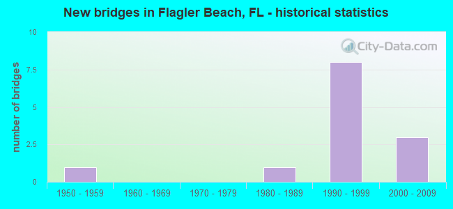
- New bridges - historical statistics
- 11950-1959
- 11980-1989
- 81990-1999
- 32000-2009


- Bridge Condition - Deck
- 16.7%Very good
- 66.7%Good
- 16.7%Fair

- Bridge Condition - Superstructure
- 33.3%Very good
- 50.0%Good
- 16.7%Fair

- Bridge Condition - Substructure
- 16.7%Very good
- 66.7%Good
- 16.7%Fair

- Bridge Condition - Channel
- 40.0%Very good
- 40.0%Good
- 20.0%Satisfactory
Find on map >> Show street view
Structure Number: 730058, Location: SR-100 WB over IWW (Lat: 29.477694, Lng: -81.136783), Route carried "on" structure: State highway 100, Year Built: 1996, Status: Open, Structure Length: 81.26m (266.60ft), Average Daily Traffic: 9,000 (year 2020), Truck Traffic: 6%, Average Future Daily Traffic: 15,615 (year 2042), Design Load: HS 20+Mod, Features Intersected: IWW Flagler Beach
Minimum Vertical Clearance: 30+ m (98+ ft), Kilometerpoint: 11.766, Lanes on structure: 2, Lanes under structure: 6, Owner: State Highway Agency, Approaching Roadway Width: 10.1m (33.1ft), Navigation Control: Yes ( Vertical Clearance: 19.9m (65.3ft), Horizontal Clearance: 68.4m (224.4ft)), Material/Design: Prestressed concrete continuous, Design/Construction: Stringer/Multi-beam, Number Of Spans In Main Unit: 19, Length of Maximum Span: 70.1m (230.0ft), Curb or Sidewalk Widths: Left: 0.0m, Right: 1.5m (4.9ft), Curb-To-Curb Width: 12.2m (40.0ft), Out-to-Out Width: 14.7m (48.2ft)
Condition: Deck: Good, Superstructure: Good, Substructure: Good, Channel: Very good, Operating Rating: 53.9 metric tons, Method Used To Determine Operating Rating: Load Factor (LF), Inventory Rating: 34.7 metric tons, Method Used To Determine Inventory Rating: Load Factor (LF), Structural Evaluation: Better than present minimum criteria, Deck Geometry: Better than present minimum criteria, Underclear: Better than present minimum criteria, Waterway Adequacy: Superior to present desirable criteria, Approach Roadway Alignment: Better than present minimum criteria, Designated Inspection Frequency: Every 24 months, Inspection Date: May 2021, Deck Structure Type: Concrete Cast-file-Place, Wearing Surface/Protective System: Wearing Surface: Monolithic Concrete, Membrane: Epoxy
Find on map >> Show street view
Structure Number: 730059, Location: SR-100 EB over IWW (Lat: 29.477503, Lng: -81.136672), Route carried "on" structure: State highway 100, Year Built: 1996, Status: Open, Structure Length: 81.26m (266.60ft), Average Daily Traffic: 9,000 (year 2020), Truck Traffic: 6%, Average Future Daily Traffic: 15,615 (year 2042), Design Load: HS 20, Features Intersected: IWW Flagler Beach
Minimum Vertical Clearance: 30+ m (98+ ft), Kilometerpoint: 11.766, Lanes on structure: 2, Lanes under structure: 6, Owner: State Highway Agency, Approaching Roadway Width: 12.1m (39.7ft), Skew: 9 degrees, Navigation Control: Yes ( Vertical Clearance: 19.5m (64.0ft), Horizontal Clearance: 68.4m (224.4ft)), Material/Design: Prestressed concrete continuous, Design/Construction: Stringer/Multi-beam, Number Of Spans In Main Unit: 19, Length of Maximum Span: 70.1m (230.0ft), Curb or Sidewalk Widths: Left: 0.0m, Right: 1.5m (4.9ft), Curb-To-Curb Width: 12.1m (39.7ft), Out-to-Out Width: 13.0m (42.7ft)
Condition: Deck: Good, Superstructure: Good, Substructure: Good, Channel: Very good, Operating Rating: 60.4 metric tons, Method Used To Determine Operating Rating: Load Testing, Inventory Rating: 35.9 metric tons, Method Used To Determine Inventory Rating: Load Testing, Structural Evaluation: Better than present minimum criteria, Deck Geometry: Better than present minimum criteria, Underclear: Equal to present minimum criteria, Waterway Adequacy: Superior to present desirable criteria, Approach Roadway Alignment: Better than present minimum criteria, Designated Inspection Frequency: Every 24 months, Inspection Date: May 2021, Deck Structure Type: Concrete Cast-file-Place, Wearing Surface/Protective System: Wearing Surface: Monolithic Concrete, Membrane: Epoxy
Find on map >> Show street view
Structure Number: 73408, Location: 2.0 Mi East of US1 (Lat: 29.599558, Lng: -81.248025), Route carried "on" structure: County highway , Year Built: 2006, Status: Open, Structure Length: 6.10m (20.01ft), Average Daily Traffic: 6,900 (year 2020), Truck Traffic: 2%, Average Future Daily Traffic: 11,971 (year 2042), Design Load: HS 20, Features Intersected: I-95, Facility Carried by Structure: Matanzas Woods Pkw
Minimum Vertical Clearance: 30+ m (98+ ft), Kilometerpoint: 0.433, Lanes on structure: 2, Lanes under structure: 6, Owner: City or Municipal Highway Agency, Approaching Roadway Width: 8.9m (29.2ft), Material/Design: Prestressed concrete, Design/Construction: Stringer/Multi-beam, Number Of Spans In Main Unit: 2, Length of Maximum Span: 30.2m (99.1ft), Curb or Sidewalk Widths: Left: 0.0m, Right: 2.4m (7.9ft), Curb-To-Curb Width: 8.9m (29.2ft), Out-to-Out Width: 12.6m (41.3ft)
Condition: Deck: Good, Superstructure: Very good, Substructure: Very good, Operating Rating: 59.0 metric tons, Method Used To Determine Operating Rating: Load Factor (LF), Inventory Rating: 36.9 metric tons, Method Used To Determine Inventory Rating: Load Factor (LF), Structural Evaluation: Equal to present desirable criteria, Deck Geometry: Meets minimum limits, Underclear: Better than present minimum criteria, Approach Roadway Alignment: Equal to present desirable criteria, Designated Inspection Frequency: Every 24 months, Inspection Date: November 2020, Deck Structure Type: Concrete Cast-file-Place
Find on map >> Show street view
Structure Number: 794025, Location: 0.3 Mile West of SR-A1A (Lat: 29.408639, Lng: -81.100889), Route carried "on" structure: County highway , Year Built: 1955, Status: Posted for load, Structure Length: 9.48m (31.10ft), Average Daily Traffic: 1,106 (year 2021), Truck Traffic: 5%, Average Future Daily Traffic: 1,324 (year 2042), Design Load: HS 20, Features Intersected: Intracoastal Waterway, Facility Carried by Structure: Highbridge Road
Minimum Vertical Clearance: 30+ m (98+ ft), Kilometerpoint: 4.413, Lanes on structure: 2, Owner: County Highway Agency, Approaching Roadway Width: 7.7m (25.3ft), Navigation Control: Yes ( Vertical Clearance: 4.8m (15.7ft), Horizontal Clearance: 27.4m (89.9ft)), Material/Design: Steel, Design/Construction: Movable - Bascule, Number Of Spans In Main Unit: 1, Number Of Approach Spans: 4, Length of Maximum Span: 40.6m (133.2ft), Curb or Sidewalk Widths: Left: 1.1m (3.6ft), Right: 1.1m (3.6ft), Curb-To-Curb Width: 8.5m (27.9ft), Out-to-Out Width: 11.3m (37.1ft)
Condition: Deck: Fair, Superstructure: Fair, Substructure: Fair, Channel: Satisfactory, Operating Rating: 37.6 metric tons, Method Used To Determine Operating Rating: Load Factor (LF), Inventory Rating: 22.5 metric tons, Method Used To Determine Inventory Rating: Load Factor (LF), Structural Evaluation: Somewhat better than minimum adequacy, Deck Geometry: Somewhat better than minimum adequacy, Waterway Adequacy: Better than present minimum criteria, Approach Roadway Alignment: Equal to present desirable criteria, Designated Inspection Frequency: Every 24 months, Critical Feature Inspection Frequency: Every 24 months, Underwater Inspection Frequency: Every 24 months, Other Special Inspection Frequency: Every 12 months, Inspection Date: April 2020, Critical Feature Inspection Date: April 2020, Underwater Inspection Date: April 2020, Other Special Inspection Date: April 2021, Deck Structure Type: Open Grating
Find on map >> Show street view
Structure Number: 794126, Location: 1.0 Mi E of Old Dixie Hwy (Lat: 29.407631, Lng: -81.121847), Route carried "on" structure: County highway , Year Built: 1988, Status: Open, Structure Length: 2.59m (8.50ft), Average Daily Traffic: 1,711 (year 2020), Truck Traffic: 5%, Average Future Daily Traffic: 2,070 (year 2042), Design Load: HS 20, Features Intersected: Bulow Creek, Facility Carried by Structure: Walter Boardman Ln
Minimum Vertical Clearance: 30+ m (98+ ft), Kilometerpoint: 1.613, Lanes on structure: 2, Owner: County Highway Agency, Approaching Roadway Width: 9.1m (29.9ft), Material/Design: Concrete continuous, Design/Construction: Slab, Number Of Spans In Main Unit: 3, Length of Maximum Span: 9.6m (31.5ft), Curb-To-Curb Width: 10.4m (34.1ft), Out-to-Out Width: 11.2m (36.7ft)
Condition: Deck: Good, Superstructure: Good, Substructure: Good, Channel: Good, Operating Rating: 60.5 metric tons, Method Used To Determine Operating Rating: Load Factor (LF), Inventory Rating: 36.3 metric tons, Method Used To Determine Inventory Rating: Load Factor (LF), Structural Evaluation: Better than present minimum criteria, Deck Geometry: Equal to present minimum criteria, Waterway Adequacy: Equal to present desirable criteria, Approach Roadway Alignment: Equal to present desirable criteria, Designated Inspection Frequency: Every 24 months, Inspection Date: May 2020, Deck Structure Type: Concrete Cast-file-Place
Find on map >> Show street view
Structure Number: 871, Location: 1 MI N OF CORAL WAY (Lat: 25.762206, Lng: -80.319689), Route carried "on" structure: Ramp State highway 826, Year Built: 2007, Status: Open, Structure Length: 3.64m (11.94ft), Average Daily Traffic: 13,500 (year 2020), Truck Traffic: 4%, Average Future Daily Traffic: 23,422 (year 2042), Design Load: HL 93, Features Intersected: CORAL GABLES CANAL
Minimum Vertical Clearance: 30.18m (99.02ft), Kilometerpoint: 0.486, Lanes on structure: 1, Owner: State Highway Agency, Approaching Roadway Width: 8.8m (28.9ft), Skew: 2 degrees, Material/Design: Concrete continuous, Design/Construction: Slab, Number Of Spans In Main Unit: 4, Length of Maximum Span: 11.1m (36.4ft), Curb-To-Curb Width: 8.8m (28.9ft), Out-to-Out Width: 9.8m (32.2ft)
Condition: Deck: Very good, Superstructure: Very good, Substructure: Good, Channel: Good, Operating Rating: 37.6 metric tons, Method Used To Determine Operating Rating: Load and Resistance Factor (LRFR), Inventory Rating: 29.0 metric tons, Method Used To Determine Inventory Rating: Load and Resistance Factor (LRFR), Structural Evaluation: Better than present minimum criteria, Deck Geometry: Superior to present desirable criteria, Waterway Adequacy: Equal to present desirable criteria, Approach Roadway Alignment: Equal to present minimum criteria, Designated Inspection Frequency: Every 24 months, Underwater Inspection Frequency: Every 24 months, Inspection Date: May 2020, Underwater Inspection Date: May 2020, Deck Structure Type: Concrete Cast-file-Place
Find on map >> Show street view
Structure Number: 730058, Location: SR-100 WB over IWW (Lat: 29.477694, Lng: -81.136783), Route carried "under" structure: ServiceCity street , Year Built: 1996, Structure Length: 0. m, Average Daily Traffic: 1,000 (year 2007), Truck Traffic: 5%, Features Intersected: IWW Flagler Beach, Facility Carried by Structure: SR-100 WB
Minimum Vertical Clearance: 16.28m (53.41ft), Kilometerpoint: 0.681, Lanes on structure: 2, Lanes under structure: 2, Material/Design: Prestressed concrete continuous, Design/Construction: Stringer/Multi-beam, Length of Maximum Span: 70.1m (230.0ft)
Find on map >> Show street view
Structure Number: 730058, Location: SR-100 WB over IWW (Lat: 29.477694, Lng: -81.136783), Route carried "under" structure: ServiceOther road , Year Built: 1996, Structure Length: 0. m, Average Daily Traffic: 10 (year 2007), Truck Traffic: 1%, Features Intersected: IWW Flagler Beach, Facility Carried by Structure: SR-100 WB
Minimum Vertical Clearance: 17.77m (58.30ft), Kilometerpoint: 0.029, Lanes on structure: 2, Lanes under structure: 2, Material/Design: Prestressed concrete continuous, Design/Construction: Stringer/Multi-beam, Length of Maximum Span: 70.1m (230.0ft)
Find on map >> Show street view
Structure Number: 730058, Location: SR-100 WB over IWW (Lat: 29.477694, Lng: -81.136783), Route carried "under" structure: ServiceOther road , Year Built: 1996, Structure Length: 0. m, Average Daily Traffic: 10 (year 2007), Truck Traffic: 1%, Features Intersected: IWW Flagler Beach, Facility Carried by Structure: SR-100 WB
Minimum Vertical Clearance: 15.24m (50.00ft), Kilometerpoint: 0.002, Lanes on structure: 2, Lanes under structure: 2, Material/Design: Prestressed concrete continuous, Design/Construction: Stringer/Multi-beam, Length of Maximum Span: 70.1m (230.0ft)
Find on map >> Show street view
Structure Number: 730059, Location: SR-100 EB over IWW (Lat: 29.477503, Lng: -81.136672), Route carried "under" structure: City street , Year Built: 1996, Structure Length: 0. m, Average Daily Traffic: 1,050 (year 2019), Truck Traffic: 10%, Features Intersected: IWW Flagler Beach, Facility Carried by Structure: SR-100 EB
Minimum Vertical Clearance: 16.27m (53.38ft), Kilometerpoint: 0.681, Lanes on structure: 2, Lanes under structure: 2, Material/Design: Prestressed concrete continuous, Design/Construction: Stringer/Multi-beam, Length of Maximum Span: 70.1m (230.0ft)
Find on map >> Show street view
Structure Number: 730059, Location: SR-100 EB over IWW (Lat: 29.477503, Lng: -81.136672), Route carried "under" structure: ServiceOther road , Year Built: 1996, Structure Length: 0. m, Average Daily Traffic: 10 (year 2007), Truck Traffic: 1%, Features Intersected: IWW Flagler Beach, Facility Carried by Structure: SR-100 EB
Minimum Vertical Clearance: 17.76m (58.27ft), Kilometerpoint: 0.029, Lanes on structure: 2, Lanes under structure: 2, Material/Design: Prestressed concrete continuous, Design/Construction: Stringer/Multi-beam, Length of Maximum Span: 70.1m (230.0ft)
Find on map >> Show street view
Structure Number: 730059, Location: SR-100 EB over IWW (Lat: 29.477503, Lng: -81.136672), Route carried "under" structure: Other road , Year Built: 1996, Structure Length: 0. m, Average Daily Traffic: 10 (year 2007), Truck Traffic: 1%, Features Intersected: IWW Flagler Beach, Facility Carried by Structure: SR-100 EB
Minimum Vertical Clearance: 15.24m (50.00ft), Kilometerpoint: 0.000, Lanes on structure: 2, Lanes under structure: 2, Material/Design: Prestressed concrete continuous, Design/Construction: Stringer/Multi-beam, Length of Maximum Span: 70.1m (230.0ft)
Find on map >> Show street view
Structure Number: 73408, Location: 2.0 Mi East of US1 (Lat: 29.599558, Lng: -81.248025), Route carried "under" structure: Interstate 9, Year Built: 2006, Structure Length: 0. m, Average Daily Traffic: 53,000 (year 2020), Truck Traffic: 17%, Features Intersected: I-95, Facility Carried by Structure: Matanzas Woods Pkw
Minimum Vertical Clearance: 5.15m (16.90ft), Kilometerpoint: 23.620, Lanes on structure: 2, Lanes under structure: 6, Material/Design: Prestressed concrete, Design/Construction: Stringer/Multi-beam, Length of Maximum Span: 30.2m (99.1ft)