Bridge Statistics for Flatonia, Texas (TX)
Condition, Traffic, Stress, Structural Evaluation, Project Costs
- National Bridge Inventory (NBI) Statistics
- 37Number of bridges
- 299ft / 91.5mTotal length
- $8,000Total costs
- 266,205Total average daily traffic
- 80,375Total average daily truck traffic
- National Bridge Inventory (NBI) Registered Bridges for Flatonia
- No street view available for this location
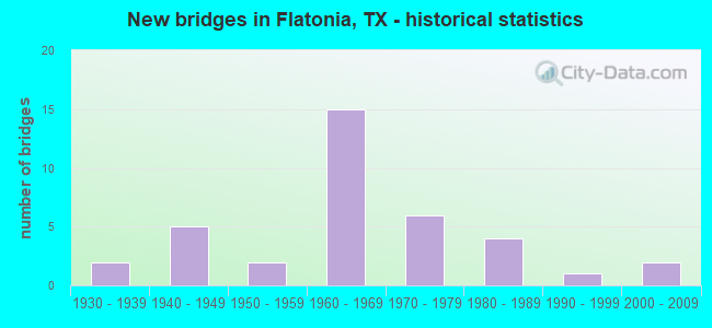
- New bridges - historical statistics
- 21930-1939
- 51940-1949
- 21950-1959
- 151960-1969
- 61970-1979
- 41980-1989
- 11990-1999
- 22000-2009


- Bridge Condition - Deck
- 21.4%Very good
- 42.9%Good
- 35.7%Satisfactory

- Bridge Condition - Superstructure
- 14.3%Very good
- 42.9%Good
- 35.7%Satisfactory
- 7.1%Fair

- Bridge Condition - Substructure
- 42.9%Good
- 50.0%Satisfactory
- 7.1%Fair

- Bridge Condition - Channel
- 33.3%Good
- 50.0%Satisfactory
- 16.7%Fair

- Bridge Condition - Culverts
- 41.2%Good
- 52.9%Satisfactory
- 5.9%Fair
Find on map >> Show street view
Structure Number: 130760002602042, Location: 0.70 MI W OF FM 2762 (Lat: 29.687617, Lng: -97.131539), Route carried "on" structure: US 90, Year Built: 1940, Status: Open, Structure Length: 0.73m (2.40ft), Average Daily Traffic: 2,014 (year 2020), Truck Traffic: 14%, Average Future Daily Traffic: 2,630 (year 2033), Design Load: H 15, Features Intersected: DRAW
Minimum Vertical Clearance: 30+ m (98+ ft), Kilometerpoint: 4.707, Lanes on structure: 2, Owner: State Highway Agency, Approaching Roadway Width: 11.3m (37.1ft), Material/Design: Concrete, Design/Construction: Culvert, Number Of Spans In Main Unit: 3, Length of Maximum Span: 2.1m (6.9ft), Curb-To-Curb Width: 12.8m (42.0ft), Out-to-Out Width: 13.6m (44.6ft)
Condition: Channel: Good, Culverts: Satisfactory, Operating Rating: 39.9 metric tons, Method Used To Determine Operating Rating: Load Factor (LF), Inventory Rating: 23.6 metric tons, Method Used To Determine Inventory Rating: Load Factor (LF), Structural Evaluation: Equal to present minimum criteria, Deck Geometry: Equal to present minimum criteria, Waterway Adequacy: Equal to present minimum criteria, Approach Roadway Alignment: Equal to present desirable criteria, Designated Inspection Frequency: Every 24 months, Inspection Date: Febuary 2021, Deck Structure Type: Concrete Cast-file-Place, Wearing Surface/Protective System: Wearing Surface: Bituminous
Find on map >> Show street view
Structure Number: 130760002602043, Location: 0.95 MI E OF FM 609 (Lat: 29.684717, Lng: -97.087981), Route carried "on" structure: US 90, Year Built: 1940, Status: Open, Structure Length: 0.82m (2.69ft), Average Daily Traffic: 1,868 (year 2020), Truck Traffic: 14%, Average Future Daily Traffic: 2,500 (year 2033), Design Load: H 15, Features Intersected: Trib of Mulberry Creek
Minimum Vertical Clearance: 30+ m (98+ ft), Kilometerpoint: 9.001, Lanes on structure: 2, Owner: State Highway Agency, Approaching Roadway Width: 11.6m (38.1ft), Material/Design: Concrete, Design/Construction: Culvert, Number Of Spans In Main Unit: 4, Length of Maximum Span: 1.8m (5.9ft), Curb-To-Curb Width: 12.8m (42.0ft), Out-to-Out Width: 13.6m (44.6ft)
Condition: Channel: Good, Culverts: Satisfactory, Operating Rating: 39.9 metric tons, Method Used To Determine Operating Rating: Load Factor (LF), Inventory Rating: 23.6 metric tons, Method Used To Determine Inventory Rating: Load Factor (LF), Structural Evaluation: Equal to present minimum criteria, Deck Geometry: Better than present minimum criteria, Waterway Adequacy: Equal to present minimum criteria, Approach Roadway Alignment: Equal to present desirable criteria, Designated Inspection Frequency: Every 24 months, Inspection Date: Febuary 2021, Deck Structure Type: Concrete Cast-file-Place, Wearing Surface/Protective System: Wearing Surface: Bituminous
Find on map >> Show street view
Structure Number: 130760002602044, Location: 1.20 MI E OF FM 609 (Lat: 29.682908, Lng: -97.084358), Route carried "on" structure: US 90, Year Built: 1940, Status: Open, Structure Length: 1.46m (4.79ft), Average Daily Traffic: 1,868 (year 2020), Truck Traffic: 14%, Average Future Daily Traffic: 2,500 (year 2033), Design Load: H 15, Features Intersected: Draw
Minimum Vertical Clearance: 30+ m (98+ ft), Kilometerpoint: 9.370, Lanes on structure: 2, Owner: State Highway Agency, Approaching Roadway Width: 11.6m (38.1ft), Skew: 4 degrees, Material/Design: Concrete, Design/Construction: Culvert, Number Of Spans In Main Unit: 5, Length of Maximum Span: 1.8m (5.9ft), Curb-To-Curb Width: 12.8m (42.0ft), Out-to-Out Width: 13.6m (44.6ft)
Condition: Channel: Good, Culverts: Satisfactory, Operating Rating: 39.9 metric tons, Method Used To Determine Operating Rating: Load Factor (LF), Inventory Rating: 23.6 metric tons, Method Used To Determine Inventory Rating: Load Factor (LF), Structural Evaluation: Equal to present minimum criteria, Deck Geometry: Better than present minimum criteria, Waterway Adequacy: Equal to present minimum criteria, Approach Roadway Alignment: Equal to present desirable criteria, Designated Inspection Frequency: Every 24 months, Inspection Date: Febuary 2021, Deck Structure Type: Concrete Cast-file-Place, Wearing Surface/Protective System: Wearing Surface: Bituminous
Find on map >> Show street view
Structure Number: 130760002602045, Location: 2.15 MI E OF FM 609 (Lat: 29.680047, Lng: -97.069461), Route carried "on" structure: US 90, Year Built: 1940, Status: Open, Structure Length: 0.67m (2.20ft), Average Daily Traffic: 1,868 (year 2020), Truck Traffic: 14%, Average Future Daily Traffic: 2,500 (year 2033), Design Load: H 15, Features Intersected: Draw
Minimum Vertical Clearance: 30+ m (98+ ft), Kilometerpoint: 10.919, Lanes on structure: 2, Owner: State Highway Agency, Approaching Roadway Width: 11.6m (38.1ft), Material/Design: Concrete, Design/Construction: Culvert, Number Of Spans In Main Unit: 2, Length of Maximum Span: 3.0m (9.8ft)
Condition: Channel: Good, Culverts: Satisfactory, Operating Rating: 39.9 metric tons, Method Used To Determine Operating Rating: Load Factor (LF), Inventory Rating: 23.6 metric tons, Method Used To Determine Inventory Rating: Load Factor (LF), Structural Evaluation: Equal to present minimum criteria, Waterway Adequacy: Equal to present minimum criteria, Approach Roadway Alignment: Equal to present desirable criteria, Designated Inspection Frequency: Every 24 months, Inspection Date: Febuary 2021
Find on map >> Show street view
Structure Number: 130760002602046, Location: 0.30 MI E OF FM 1295 (Lat: 29.680572, Lng: -97.061394), Route carried "on" structure: US 90, Year Built: 1940, Status: Open, Structure Length: 0.67m (2.20ft), Average Daily Traffic: 1,463 (year 2020), Truck Traffic: 14%, Average Future Daily Traffic: 2,040 (year 2033), Design Load: H 15, Features Intersected: Trib of Mulberry Creek
Minimum Vertical Clearance: 30+ m (98+ ft), Kilometerpoint: 11.708, Lanes on structure: 2, Owner: State Highway Agency, Approaching Roadway Width: 11.6m (38.1ft), Material/Design: Concrete, Design/Construction: Culvert, Number Of Spans In Main Unit: 2, Length of Maximum Span: 3.0m (9.8ft)
Condition: Channel: Satisfactory, Culverts: Fair, Operating Rating: 39.9 metric tons, Method Used To Determine Operating Rating: Load Factor (LF), Inventory Rating: 23.6 metric tons, Method Used To Determine Inventory Rating: Load Factor (LF), Structural Evaluation: Somewhat better than minimum adequacy, Waterway Adequacy: Equal to present minimum criteria, Approach Roadway Alignment: Equal to present desirable criteria, Designated Inspection Frequency: Every 24 months, Inspection Date: April 2021
Find on map >> Show street view
Structure Number: 130760026704018, Location: 0.30 MI S OF US 90 (Lat: 29.675417, Lng: -97.066539), Route carried "on" structure: State highway 1295, Year Built: 1936, Year Reconstructed: 1952, Status: Open, Structure Length: 0.98m (3.22ft), Average Daily Traffic: 909 (year 2020), Truck Traffic: 12%, Average Future Daily Traffic: 870 (year 2033), Design Load: H 15, Features Intersected: Mulberry Creek
Minimum Vertical Clearance: 30+ m (98+ ft), Kilometerpoint: 0.510, Lanes on structure: 2, Owner: State Highway Agency, Approaching Roadway Width: 6.7m (22.0ft), Skew: 1 degrees, Material/Design: Steel continuous, Design/Construction: Stringer/Multi-beam, Number Of Spans In Main Unit: 2, Length of Maximum Span: 4.9m (16.1ft), Curb-To-Curb Width: 6.1m (20.0ft), Out-to-Out Width: 6.6m (21.7ft)
Condition: Deck: Satisfactory, Superstructure: Fair, Substructure: Good, Channel: Good, Operating Rating: 49.0 metric tons, Method Used To Determine Operating Rating: Load Factor (LF), Inventory Rating: 29.0 metric tons, Method Used To Determine Inventory Rating: Load Factor (LF), Structural Evaluation: Somewhat better than minimum adequacy, Deck Geometry: High priority of corrective action, Waterway Adequacy: Better than present minimum criteria, Approach Roadway Alignment: Equal to present desirable criteria, Length Of Structure Improvement: 0.98m (3.22ft), Designated Inspection Frequency: Every 24 months, Inspection Date: April 2021, Bridge Improvement Cost: $1,000, Total Project Cost: $1,000, Deck Structure Type: Concrete Cast-file-Place, Wearing Surface/Protective System: Wearing Surface: Bituminous
Find on map >> Show street view
Structure Number: 130760026704023, Location: 0.84 MI S OF US 90 (Lat: 29.668075, Lng: -97.067167), Route carried "on" structure: State highway 1295, Year Built: 1959, Status: Open, Structure Length: 0.88m (2.89ft), Average Daily Traffic: 909 (year 2020), Truck Traffic: 12%, Average Future Daily Traffic: 870 (year 2033), Features Intersected: Trib of Mulberry Creek
Minimum Vertical Clearance: 30+ m (98+ ft), Kilometerpoint: 1.358, Lanes on structure: 2, Owner: State Highway Agency, Approaching Roadway Width: 7.3m (24.0ft), Skew: 4 degrees, Material/Design: Concrete, Design/Construction: Culvert, Number Of Spans In Main Unit: 3, Length of Maximum Span: 1.8m (5.9ft), Curb-To-Curb Width: 12.2m (40.0ft), Out-to-Out Width: 12.6m (41.3ft)
Condition: Channel: Satisfactory, Culverts: Satisfactory, Operating Rating: 39.9 metric tons, Method Used To Determine Operating Rating: Load Factor (LF), Inventory Rating: 23.6 metric tons, Method Used To Determine Inventory Rating: Load Factor (LF), Structural Evaluation: Equal to present minimum criteria, Deck Geometry: Equal to present desirable criteria, Waterway Adequacy: Better than present minimum criteria, Approach Roadway Alignment: Equal to present desirable criteria, Designated Inspection Frequency: Every 24 months, Inspection Date: April 2021, Deck Structure Type: Concrete Cast-file-Place, Wearing Surface/Protective System: Wearing Surface: Bituminous
Find on map >> Show street view
Structure Number: 130760026704024, Location: 1.66 MI S OF US 90 (Lat: 29.656272, Lng: -97.066147), Route carried "on" structure: State highway 1295, Year Built: 1959, Status: Open, Structure Length: 0.70m (2.30ft), Average Daily Traffic: 909 (year 2020), Truck Traffic: 12%, Average Future Daily Traffic: 870 (year 2033), Features Intersected: Trib of Mulberry Creek
Minimum Vertical Clearance: 30+ m (98+ ft), Kilometerpoint: 2.668, Lanes on structure: 2, Owner: State Highway Agency, Approaching Roadway Width: 7.3m (24.0ft), Material/Design: Concrete, Design/Construction: Culvert, Number Of Spans In Main Unit: 3, Length of Maximum Span: 2.1m (6.9ft), Curb-To-Curb Width: 12.2m (40.0ft), Out-to-Out Width: 12.6m (41.3ft)
Condition: Channel: Satisfactory, Culverts: Good, Operating Rating: 39.9 metric tons, Method Used To Determine Operating Rating: Load Factor (LF), Inventory Rating: 23.6 metric tons, Method Used To Determine Inventory Rating: Load Factor (LF), Structural Evaluation: Equal to present minimum criteria, Deck Geometry: Equal to present desirable criteria, Waterway Adequacy: Better than present minimum criteria, Approach Roadway Alignment: Equal to present desirable criteria, Designated Inspection Frequency: Every 24 months, Inspection Date: April 2021, Deck Structure Type: Concrete Cast-file-Place, Wearing Surface/Protective System: Wearing Surface: Bituminous
Find on map >> Show street view
Structure Number: 130760032303021, Location: 1.17 MI S OF FM 154 (Lat: 29.707619, Lng: -97.109339), Route carried "on" structure: State highway 95, Year Built: 1969, Status: Open, Structure Length: 1.04m (3.41ft), Average Daily Traffic: 2,171 (year 2020), Truck Traffic: 19%, Average Future Daily Traffic: 4,160 (year 2033), Design Load: HS 20, Features Intersected: Draw
Minimum Vertical Clearance: 30+ m (98+ ft), Kilometerpoint: 28.072, Lanes on structure: 2, Owner: State Highway Agency, Approaching Roadway Width: 14.2m (46.6ft), Skew: 3 degrees, Material/Design: Concrete, Design/Construction: Culvert, Number Of Spans In Main Unit: 3, Length of Maximum Span: 2.7m (8.9ft), Out-to-Out Width: 19.3m (63.3ft)
Condition: Channel: Satisfactory, Culverts: Good, Operating Rating: 39.9 metric tons, Method Used To Determine Operating Rating: Load Factor (LF), Inventory Rating: 23.6 metric tons, Method Used To Determine Inventory Rating: Load Factor (LF), Structural Evaluation: Equal to present minimum criteria, Waterway Adequacy: Equal to present minimum criteria, Approach Roadway Alignment: Equal to present desirable criteria, Designated Inspection Frequency: Every 24 months, Inspection Date: May 2021
Find on map >> Show street view
Structure Number: 130760032303022, Location: 1.42 MI S OF FM 154 (Lat: 29.703911, Lng: -97.109050), Route carried "on" structure: State highway 95, Year Built: 1969, Status: Open, Structure Length: 2.04m (6.69ft), Average Daily Traffic: 2,171 (year 2020), Truck Traffic: 19%, Average Future Daily Traffic: 4,160 (year 2033), Design Load: HS 20, Features Intersected: Draw
Minimum Vertical Clearance: 30+ m (98+ ft), Kilometerpoint: 28.476, Lanes on structure: 2, Owner: State Highway Agency, Approaching Roadway Width: 13.9m (45.6ft), Skew: 3 degrees, Material/Design: Concrete, Design/Construction: Culvert, Number Of Spans In Main Unit: 6, Length of Maximum Span: 2.7m (8.9ft), Out-to-Out Width: 22.3m (73.2ft)
Condition: Channel: Satisfactory, Culverts: Good, Operating Rating: 39.9 metric tons, Method Used To Determine Operating Rating: Load Factor (LF), Inventory Rating: 23.6 metric tons, Method Used To Determine Inventory Rating: Load Factor (LF), Structural Evaluation: Equal to present minimum criteria, Waterway Adequacy: Equal to present minimum criteria, Approach Roadway Alignment: Equal to present desirable criteria, Designated Inspection Frequency: Every 24 months, Inspection Date: May 2021
Find on map >> Show street view
Structure Number: 130760032303024, Location: 1.70 MI N OF IH 10 (Lat: 29.720086, Lng: -97.113519), Route carried "on" structure: State highway 95, Year Built: 1986, Status: Open, Structure Length: 8.99m (29.49ft), Average Daily Traffic: 1,567 (year 2020), Truck Traffic: 19%, Average Future Daily Traffic: 2,800 (year 2033), Design Load: HS 20, Features Intersected: UNION PACIFIC RAILROAD
Minimum Vertical Clearance: 30+ m (98+ ft), Kilometerpoint: 26.482, Lanes on structure: 2, Owner: State Highway Agency, Approaching Roadway Width: 13.4m (44.0ft), Skew: 3 degrees, Material/Design: Prestressed concrete, Design/Construction: Stringer/Multi-beam, Number Of Spans In Main Unit: 1, Number Of Approach Spans: 4, Length of Maximum Span: 22.9m (75.1ft), Curb-To-Curb Width: 13.1m (43.0ft), Out-to-Out Width: 14.0m (45.9ft)
Condition: Deck: Good, Superstructure: Very good, Substructure: Good, Operating Rating: 54.4 metric tons, Method Used To Determine Operating Rating: Assigned rating based on Load Factor Design (LFD) reported in metric tons, Inventory Rating: 32.7 metric tons, Method Used To Determine Inventory Rating: Assigned rating based on Load Factor Design (LFD) reported in metric tons, Structural Evaluation: Better than present minimum criteria, Deck Geometry: Better than present minimum criteria, Underclear: Better than present minimum criteria, Approach Roadway Alignment: Equal to present desirable criteria, Designated Inspection Frequency: Every 24 months, Inspection Date: March 2021, Deck Structure Type: Concrete Precast Panels, Wearing Surface/Protective System: Wearing Surface: Bituminous
Find on map >> Show street view
Structure Number: 130760053506098, Location: 0.4 MI W OF FM 609 (Lat: 29.696719, Lng: -97.108581), Route carried "on" structure: State highway 95, Year Built: 1969, Status: Open, Structure Length: 9.14m (29.99ft), Average Daily Traffic: 2,970 (year 2013), Truck Traffic: 19%, Average Future Daily Traffic: 4,160 (year 2033), Design Load: H 20, Features Intersected: IH 10
Minimum Vertical Clearance: 30+ m (98+ ft), Kilometerpoint: 29.245, Lanes on structure: 2, Lanes under structure: 4, Owner: State Highway Agency, Approaching Roadway Width: 12.8m (42.0ft), Material/Design: Prestressed concrete, Design/Construction: Stringer/Multi-beam, Number Of Spans In Main Unit: 4, Length of Maximum Span: 24.4m (80.1ft), Curb-To-Curb Width: 13.6m (44.6ft), Out-to-Out Width: 14.1m (46.3ft)
Condition: Deck: Good, Superstructure: Very good, Substructure: Good, Operating Rating: 64.4 metric tons, Method Used To Determine Operating Rating: Load Factor (LF), Inventory Rating: 27.2 metric tons, Method Used To Determine Inventory Rating: Load Factor (LF), Structural Evaluation: Equal to present minimum criteria, Deck Geometry: Superior to present desirable criteria, Underclear: Somewhat better than minimum adequacy, Approach Roadway Alignment: Equal to present desirable criteria, Designated Inspection Frequency: Every 24 months, Inspection Date: March 2021, Deck Structure Type: Concrete Cast-file-Place
Find on map >> Show street view
Structure Number: 130760053506099, Location: 0.18 MI E OF SH 95 (Lat: 29.697486, Lng: -97.105506), Route carried "on" structure: ServiceInterstate 10, Year Built: 1969, Status: Open, Structure Length: 0.67m (2.20ft), Average Daily Traffic: 9,360 (year 2008), Truck Traffic: 38%, Average Future Daily Traffic: 16,310 (year 2030), Design Load: HS 20, Features Intersected: Big Fivemile Creek
Minimum Vertical Clearance: 30+ m (98+ ft), Kilometerpoint: 8.721, Lanes on structure: 2, Owner: State Highway Agency, Approaching Roadway Width: 13.4m (44.0ft), Material/Design: Concrete, Design/Construction: Culvert, Number Of Spans In Main Unit: 2, Length of Maximum Span: 3.0m (9.8ft), Curb-To-Curb Width: 14.5m (47.6ft), Out-to-Out Width: 17.2m (56.4ft)
Condition: Channel: Good, Culverts: Good, Operating Rating: 39.9 metric tons, Method Used To Determine Operating Rating: Load Factor (LF), Inventory Rating: 23.6 metric tons, Method Used To Determine Inventory Rating: Load Factor (LF), Structural Evaluation: Somewhat better than minimum adequacy, Deck Geometry: Superior to present desirable criteria, Waterway Adequacy: Equal to present minimum criteria, Approach Roadway Alignment: Equal to present desirable criteria, Designated Inspection Frequency: Every 24 months, Inspection Date: May 2021, Deck Structure Type: Concrete Cast-file-Place, Wearing Surface/Protective System: Wearing Surface: Bituminous
Find on map >> Show street view
Structure Number: 1307600535061, Location: 0.18 MI E OF SH 95 (Lat: 29.696000, Lng: -97.106011), Route carried "on" structure: ServiceInterstate 10, Year Built: 1969, Status: Open, Structure Length: 1.49m (4.89ft), Average Daily Traffic: 9,360 (year 2008), Truck Traffic: 38%, Average Future Daily Traffic: 16,310 (year 2030), Design Load: HS 20, Features Intersected: Big Fivemile Creek
Minimum Vertical Clearance: 30+ m (98+ ft), Kilometerpoint: 10.266, Lanes on structure: 2, Owner: State Highway Agency, Approaching Roadway Width: 13.7m (44.9ft), Skew: 4 degrees, Material/Design: Concrete, Design/Construction: Culvert, Number Of Spans In Main Unit: 4, Length of Maximum Span: 2.4m (7.9ft), Curb-To-Curb Width: 13.7m (44.9ft), Out-to-Out Width: 18.7m (61.4ft)
Condition: Channel: Good, Culverts: Good, Operating Rating: 39.9 metric tons, Method Used To Determine Operating Rating: Load Factor (LF), Inventory Rating: 23.6 metric tons, Method Used To Determine Inventory Rating: Load Factor (LF), Structural Evaluation: Somewhat better than minimum adequacy, Deck Geometry: Superior to present desirable criteria, Waterway Adequacy: Equal to present minimum criteria, Approach Roadway Alignment: Equal to present desirable criteria, Designated Inspection Frequency: Every 24 months, Inspection Date: May 2021, Deck Structure Type: Concrete Cast-file-Place, Wearing Surface/Protective System: Wearing Surface: Bituminous
Find on map >> Show street view
Structure Number: 130760053506101, Location: 0.4 MI E OF SH 95 (Lat: 29.696961, Lng: -97.102478), Route carried "on" structure: Interstate 10, Year Built: 1969, Status: Open, Structure Length: 6.40m (21.00ft), Average Daily Traffic: 14,943 (year 2017), Truck Traffic: 38%, Average Future Daily Traffic: 17,450 (year 2033), Design Load: HS 20, Features Intersected: FM 609
Minimum Vertical Clearance: 30+ m (98+ ft), Kilometerpoint: 9.030, Lanes on structure: 2, Lanes under structure: 4, Base Highway Network: Yes, Owner: State Highway Agency, Approaching Roadway Width: 12.2m (40.0ft), Skew: 3 degrees, Material/Design: Prestressed concrete, Design/Construction: Stringer/Multi-beam, Number Of Spans In Main Unit: 3, Length of Maximum Span: 21.3m (69.9ft), Curb-To-Curb Width: 12.2m (40.0ft), Out-to-Out Width: 12.9m (42.3ft)
Condition: Deck: Very good, Superstructure: Good, Substructure: Satisfactory, Operating Rating: 68.0 metric tons, Method Used To Determine Operating Rating: Load Factor (LF), Inventory Rating: 29.9 metric tons, Method Used To Determine Inventory Rating: Load Factor (LF), Structural Evaluation: Equal to present minimum criteria, Deck Geometry: Better than present minimum criteria, Underclear: High priority of corrective action, Approach Roadway Alignment: Equal to present desirable criteria, Designated Inspection Frequency: Every 24 months, Inspection Date: March 2021, Deck Structure Type: Concrete Cast-file-Place, Wearing Surface/Protective System: Wearing Surface: Bituminous
Find on map >> Show street view
Structure Number: 130760053506102, Location: 0.4 MI E OF SH 95 (Lat: 29.696781, Lng: -97.102478), Route carried "on" structure: Interstate 10, Year Built: 1969, Status: Open, Structure Length: 6.40m (21.00ft), Average Daily Traffic: 14,913 (year 2017), Truck Traffic: 38%, Average Future Daily Traffic: 17,450 (year 2033), Design Load: HS 20, Features Intersected: FM 609
Minimum Vertical Clearance: 30+ m (98+ ft), Kilometerpoint: 9.009, Lanes on structure: 2, Lanes under structure: 4, Base Highway Network: Yes, Owner: State Highway Agency, Approaching Roadway Width: 12.2m (40.0ft), Skew: 3 degrees, Material/Design: Prestressed concrete, Design/Construction: Stringer/Multi-beam, Number Of Spans In Main Unit: 3, Length of Maximum Span: 21.3m (69.9ft), Curb-To-Curb Width: 12.2m (40.0ft), Out-to-Out Width: 12.9m (42.3ft)
Condition: Deck: Very good, Superstructure: Satisfactory, Substructure: Good, Operating Rating: 68.0 metric tons, Method Used To Determine Operating Rating: Load Factor (LF), Inventory Rating: 29.0 metric tons, Method Used To Determine Inventory Rating: Load Factor (LF), Structural Evaluation: Equal to present minimum criteria, Deck Geometry: Better than present minimum criteria, Underclear: High priority of corrective action, Approach Roadway Alignment: Equal to present desirable criteria, Designated Inspection Frequency: Every 24 months, Inspection Date: March 2021, Deck Structure Type: Concrete Cast-file-Place, Wearing Surface/Protective System: Wearing Surface: Bituminous
Find on map >> Show street view
Structure Number: 130760053506103, Location: 3.00 MI E OF SH 95 (Lat: 29.697931, Lng: -97.059211), Route carried "on" structure: County highway , Year Built: 1969, Status: Open, Structure Length: 9.14m (29.99ft), Average Daily Traffic: 70 (year 2015), Truck Traffic: 1%, Average Future Daily Traffic: 300 (year 2035), Design Load: H 15, Features Intersected: IH 10, Facility Carried by Structure: KNEZEK RD
Minimum Vertical Clearance: 30+ m (98+ ft), Kilometerpoint: 0.000, Lanes on structure: 2, Lanes under structure: 4, Owner: State Highway Agency, Approaching Roadway Width: 7.3m (24.0ft), Material/Design: Prestressed concrete, Design/Construction: Stringer/Multi-beam, Number Of Spans In Main Unit: 4, Length of Maximum Span: 24.4m (80.1ft), Curb-To-Curb Width: 7.9m (25.9ft), Out-to-Out Width: 8.6m (28.2ft)
Condition: Deck: Good, Superstructure: Good, Substructure: Satisfactory, Operating Rating: 58.0 metric tons, Method Used To Determine Operating Rating: Load Factor (LF), Inventory Rating: 20.9 metric tons, Method Used To Determine Inventory Rating: Load Factor (LF), Structural Evaluation: Equal to present minimum criteria, Deck Geometry: Equal to present minimum criteria, Underclear: Somewhat better than minimum adequacy, Approach Roadway Alignment: Equal to present desirable criteria, Designated Inspection Frequency: Every 24 months, Inspection Date: March 2021, Deck Structure Type: Concrete Cast-file-Place, Wearing Surface/Protective System: Wearing Surface: Bituminous
Find on map >> Show street view
Structure Number: 130760053506104, Location: 3.20 MI E OF FM 609 (Lat: 29.697281, Lng: -97.049158), Route carried "on" structure: Interstate 10, Year Built: 1969, Status: Open, Structure Length: 0.76m (2.49ft), Average Daily Traffic: 29,287 (year 2020), Truck Traffic: 38%, Average Future Daily Traffic: 19,810 (year 2033), Design Load: HS 20, Features Intersected: Draw
Minimum Vertical Clearance: 30+ m (98+ ft), Kilometerpoint: 14.194, Lanes on structure: 2, Owner: State Highway Agency, Approaching Roadway Width: 11.6m (38.1ft), Skew: 3 degrees, Material/Design: Concrete, Design/Construction: Culvert, Number Of Spans In Main Unit: 2, Length of Maximum Span: 3.0m (9.8ft), Out-to-Out Width: 31.8m (104.3ft)
Condition: Channel: Good, Culverts: Good, Operating Rating: 39.9 metric tons, Method Used To Determine Operating Rating: Load Factor (LF), Inventory Rating: 23.6 metric tons, Method Used To Determine Inventory Rating: Load Factor (LF), Structural Evaluation: Somewhat better than minimum adequacy, Waterway Adequacy: Equal to present minimum criteria, Approach Roadway Alignment: Equal to present desirable criteria, Designated Inspection Frequency: Every 24 months, Inspection Date: May 2021
Find on map >> Show street view
Structure Number: 130760053506105, Location: 3.80 MI E OF SH 95 (Lat: 29.697972, Lng: -97.045600), Route carried "on" structure: Interstate 10, Year Built: 1969, Status: Open, Structure Length: 0.67m (2.20ft), Average Daily Traffic: 16,528 (year 2017), Truck Traffic: 35%, Average Future Daily Traffic: 17,300 (year 2033), Design Load: HS 20, Features Intersected: DRAW
Minimum Vertical Clearance: 30+ m (98+ ft), Kilometerpoint: 14.521, Lanes on structure: 2, Owner: State Highway Agency, Approaching Roadway Width: 11.6m (38.1ft), Material/Design: Concrete, Design/Construction: Culvert, Number Of Spans In Main Unit: 2, Length of Maximum Span: 3.0m (9.8ft)
Condition: Channel: Fair, Culverts: Satisfactory, Operating Rating: 39.9 metric tons, Method Used To Determine Operating Rating: Load Factor (LF), Inventory Rating: 23.6 metric tons, Method Used To Determine Inventory Rating: Load Factor (LF), Structural Evaluation: Somewhat better than minimum adequacy, Waterway Adequacy: Equal to present minimum criteria, Approach Roadway Alignment: Equal to present desirable criteria, Designated Inspection Frequency: Every 24 months, Inspection Date: March 2021
Find on map >> Show street view
Structure Number: 130760053506176, Location: 2.90 MI W OF SH 95 (Lat: 29.693397, Lng: -97.156514), Route carried "on" structure: County highway , Year Built: 1971, Status: Open, Structure Length: 10.55m (34.61ft), Average Daily Traffic: 70 (year 2015), Truck Traffic: 10%, Average Future Daily Traffic: 300 (year 2035), Design Load: H 15, Features Intersected: IH 10, Facility Carried by Structure: OLD WAELDER RD
Minimum Vertical Clearance: 30+ m (98+ ft), Kilometerpoint: 4.506, Lanes on structure: 2, Lanes under structure: 4, Owner: State Highway Agency, Approaching Roadway Width: 6.1m (20.0ft), Skew: 3 degrees, Material/Design: Prestressed concrete, Design/Construction: Stringer/Multi-beam, Number Of Spans In Main Unit: 2, Number Of Approach Spans: 2, Length of Maximum Span: 32.9m (107.9ft), Curb-To-Curb Width: 7.9m (25.9ft), Out-to-Out Width: 8.6m (28.2ft)
Condition: Deck: Good, Superstructure: Good, Substructure: Good, Operating Rating: 63.5 metric tons, Method Used To Determine Operating Rating: Load Factor (LF), Inventory Rating: 19.0 metric tons, Method Used To Determine Inventory Rating: Load Factor (LF), Structural Evaluation: Somewhat better than minimum adequacy, Deck Geometry: Equal to present minimum criteria, Underclear: Somewhat better than minimum adequacy, Approach Roadway Alignment: Equal to present desirable criteria, Designated Inspection Frequency: Every 24 months, Inspection Date: March 2021, Deck Structure Type: Concrete Cast-file-Place, Wearing Surface/Protective System: Wearing Surface: Bituminous
Find on map >> Show street view
Structure Number: 130760053506177, Location: 2.10 MI W OF SH 95 (Lat: 29.696508, Lng: -97.144189), Route carried "on" structure: Interstate 10, Year Built: 1971, Status: Open, Structure Length: 0.94m (3.08ft), Average Daily Traffic: 28,500 (year 2020), Truck Traffic: 26%, Average Future Daily Traffic: 20,520 (year 2033), Design Load: HS 20, Features Intersected: Hog Branch
Minimum Vertical Clearance: 30+ m (98+ ft), Kilometerpoint: 4.991, Lanes on structure: 2, Owner: State Highway Agency, Approaching Roadway Width: 12.2m (40.0ft), Skew: 4 degrees, Material/Design: Concrete, Design/Construction: Culvert, Number Of Spans In Main Unit: 2, Length of Maximum Span: 3.0m (9.8ft), Out-to-Out Width: 38.8m (127.3ft)
Condition: Channel: Satisfactory, Culverts: Satisfactory, Operating Rating: 39.9 metric tons, Method Used To Determine Operating Rating: Load Factor (LF), Inventory Rating: 23.6 metric tons, Method Used To Determine Inventory Rating: Load Factor (LF), Structural Evaluation: Somewhat better than minimum adequacy, Waterway Adequacy: Equal to present minimum criteria, Approach Roadway Alignment: Equal to present desirable criteria, Designated Inspection Frequency: Every 24 months, Inspection Date: May 2021
Find on map >> Show street view
Structure Number: 130760053506178, Location: 2.10 MI W OF SH 95 (Lat: 29.695900, Lng: -97.143350), Route carried "on" structure: Interstate 10, Year Built: 1971, Status: Open, Structure Length: 0.94m (3.08ft), Average Daily Traffic: 28,500 (year 2020), Truck Traffic: 26%, Average Future Daily Traffic: 20,520 (year 2033), Design Load: HS 20, Features Intersected: Hog Branch
Minimum Vertical Clearance: 30+ m (98+ ft), Kilometerpoint: 5.082, Lanes on structure: 2, Owner: State Highway Agency, Approaching Roadway Width: 12.2m (40.0ft), Skew: 4 degrees, Material/Design: Concrete, Design/Construction: Culvert, Number Of Spans In Main Unit: 2, Length of Maximum Span: 3.0m (9.8ft), Out-to-Out Width: 33.9m (111.2ft)
Condition: Channel: Satisfactory, Culverts: Satisfactory, Operating Rating: 39.9 metric tons, Method Used To Determine Operating Rating: Load Factor (LF), Inventory Rating: 23.6 metric tons, Method Used To Determine Inventory Rating: Load Factor (LF), Structural Evaluation: Somewhat better than minimum adequacy, Waterway Adequacy: Equal to present minimum criteria, Approach Roadway Alignment: Equal to present desirable criteria, Designated Inspection Frequency: Every 24 months, Inspection Date: May 2021
Find on map >> Show street view
Structure Number: 130760053506179, Location: 1.15 MI W OF SH 95 (Lat: 29.696494, Lng: -97.128169), Route carried "on" structure: State highway 2762, Year Built: 1971, Status: Open, Structure Length: 12.92m (42.39ft), Average Daily Traffic: 290 (year 2013), Truck Traffic: 10%, Average Future Daily Traffic: 410 (year 2033), Design Load: H 15, Features Intersected: IH 10
Minimum Vertical Clearance: 30+ m (98+ ft), Kilometerpoint: 12.477, Lanes on structure: 2, Lanes under structure: 4, Owner: State Highway Agency, Approaching Roadway Width: 7.3m (24.0ft), Skew: 4 degrees, Material/Design: Prestressed concrete, Design/Construction: Stringer/Multi-beam, Number Of Spans In Main Unit: 2, Number Of Approach Spans: 2, Length of Maximum Span: 40.2m (131.9ft), Curb-To-Curb Width: 8.1m (26.6ft), Out-to-Out Width: 8.7m (28.5ft)
Condition: Deck: Very good, Superstructure: Good, Substructure: Good, Operating Rating: 59.0 metric tons, Method Used To Determine Operating Rating: Load Factor (LF), Inventory Rating: 20.9 metric tons, Method Used To Determine Inventory Rating: Load Factor (LF), Structural Evaluation: Equal to present minimum criteria, Deck Geometry: Somewhat better than minimum adequacy, Underclear: Somewhat better than minimum adequacy, Approach Roadway Alignment: Equal to present desirable criteria, Designated Inspection Frequency: Every 24 months, Inspection Date: March 2021, Deck Structure Type: Concrete Cast-file-Place, Wearing Surface/Protective System: Wearing Surface: Bituminous
Find on map >> Show street view
Structure Number: 130760282001001, Location: 1.80 MI NW OF IH 10 (Lat: 29.709522, Lng: -97.152994), Route carried "on" structure: State highway 2762, Year Built: 1963, Status: Open, Structure Length: 2.29m (7.51ft), Average Daily Traffic: 327 (year 2020), Truck Traffic: 12%, Average Future Daily Traffic: 430 (year 2037), Design Load: H 15, Features Intersected: BIG FIVEMILE CREEK
Minimum Vertical Clearance: 30+ m (98+ ft), Kilometerpoint: 9.555, Lanes on structure: 2, Owner: State Highway Agency, Approaching Roadway Width: 6.7m (22.0ft), Skew: 3 degrees, Material/Design: Concrete, Design/Construction: Slab, Number Of Spans In Main Unit: 3, Length of Maximum Span: 7.6m (24.9ft), Curb-To-Curb Width: 7.1m (23.3ft), Out-to-Out Width: 7.7m (25.3ft)
Condition: Deck: Good, Superstructure: Good, Substructure: Satisfactory, Channel: Satisfactory, Operating Rating: 68.0 metric tons, Method Used To Determine Operating Rating: Load Factor (LF), Inventory Rating: 35.4 metric tons, Method Used To Determine Inventory Rating: Load Factor (LF), Structural Evaluation: Equal to present minimum criteria, Deck Geometry: Meets minimum limits, Waterway Adequacy: Better than present minimum criteria, Approach Roadway Alignment: Equal to present desirable criteria, Designated Inspection Frequency: Every 24 months, Inspection Date: April 2021, Deck Structure Type: Concrete Cast-file-Place, Wearing Surface/Protective System: Wearing Surface: Bituminous
Find on map >> Show street view
Structure Number: 130760AA0133001, Location: 1.05 MI N OF FM 2672 (Lat: 29.713508, Lng: -97.135800), Route carried "on" structure: County highway 178, Year Built: 1990, Status: Open, Structure Length: 1.40m (4.59ft), Average Daily Traffic: 80 (year 2018), Average Future Daily Traffic: 100 (year 2038), Features Intersected: BIG FIVEMILE CREEK
Minimum Vertical Clearance: 30+ m (98+ ft), Kilometerpoint: 6.518, Lanes on structure: 1, Owner: County Highway Agency, Approaching Roadway Width: 3.7m (12.1ft), Material/Design: Steel, Number Of Spans In Main Unit: 1, Length of Maximum Span: 12.5m (41.0ft), Curb-To-Curb Width: 4.9m (16.1ft), Out-to-Out Width: 5.3m (17.4ft)
Condition: Deck: Satisfactory, Superstructure: Satisfactory, Substructure: Satisfactory, Channel: Fair, Operating Rating: 32.7 metric tons, Method Used To Determine Operating Rating: Field evaluation and documented engineering judgment, Inventory Rating: 24.5 metric tons, Method Used To Determine Inventory Rating: Field evaluation and documented engineering judgment, Structural Evaluation: Equal to present minimum criteria, Deck Geometry: High priority of corrective action, Waterway Adequacy: Better than present minimum criteria, Approach Roadway Alignment: Equal to present desirable criteria, Designated Inspection Frequency: Every 24 months, Inspection Date: Febuary 2020, Deck Structure Type: Steel plate, Wearing Surface/Protective System: Wearing Surface: Bituminous
Find on map >> Show street view
Structure Number: 130760AA0154001, Location: 0.15 MI S OF US 90 (Lat: 29.679319, Lng: -97.168881), Route carried "on" structure: County highway , Year Built: 2008, Status: Open, Structure Length: 1.01m (3.31ft), Average Daily Traffic: 20 (year 2012), Average Future Daily Traffic: 80 (year 2032), Design Load: HS 20, Features Intersected: CEDAR CREEK, Facility Carried by Structure: WHISTLEVILLE ROAD
Minimum Vertical Clearance: 30+ m (98+ ft), Kilometerpoint: 0.241, Lanes on structure: 2, Owner: County Highway Agency, Approaching Roadway Width: 4.9m (16.1ft), Skew: 1 degrees, Material/Design: Concrete, Design/Construction: Culvert, Number Of Spans In Main Unit: 3, Length of Maximum Span: 3.0m (9.8ft), Curb-To-Curb Width: 7.8m (25.6ft), Out-to-Out Width: 8.5m (27.9ft)
Condition: Channel: Fair, Culverts: Satisfactory, Operating Rating: 54.4 metric tons, Method Used To Determine Operating Rating: Assigned rating based on Load Factor Design (LFD) reported in metric tons, Inventory Rating: 32.7 metric tons, Method Used To Determine Inventory Rating: Assigned rating based on Load Factor Design (LFD) reported in metric tons, Structural Evaluation: Equal to present minimum criteria, Deck Geometry: Equal to present minimum criteria, Waterway Adequacy: Equal to present minimum criteria, Approach Roadway Alignment: Equal to present desirable criteria, Designated Inspection Frequency: Every 24 months, Inspection Date: Febuary 2020, Deck Structure Type: Concrete Cast-file-Place, Wearing Surface/Protective System: Wearing Surface: Bituminous
Find on map >> Show street view
Structure Number: 130760AA0314001, Location: 1.65 MI E OF SH 95 (Lat: 29.638136, Lng: -97.102258), Route carried "on" structure: County highway 319, Year Built: 1983, Status: Open, Structure Length: 1.68m (5.51ft), Average Daily Traffic: 30 (year 2012), Average Future Daily Traffic: 80 (year 2032), Features Intersected: BIG ROCKY CREEK, Facility Carried by Structure: E WIEDEMANN RD
Minimum Vertical Clearance: 30+ m (98+ ft), Kilometerpoint: 4.184, Lanes on structure: 1, Owner: County Highway Agency, Approaching Roadway Width: 4.9m (16.1ft), Material/Design: Steel, Number Of Spans In Main Unit: 1, Length of Maximum Span: 15.5m (50.9ft), Curb-To-Curb Width: 5.8m (19.0ft), Out-to-Out Width: 6.0m (19.7ft)
Condition: Deck: Satisfactory, Superstructure: Satisfactory, Substructure: Satisfactory, Channel: Satisfactory, Operating Rating: 32.7 metric tons, Method Used To Determine Operating Rating: Allowable Stress (AS), Inventory Rating: 21.8 metric tons, Method Used To Determine Inventory Rating: Allowable Stress (AS), Structural Evaluation: Equal to present minimum criteria, Deck Geometry: Meets minimum limits, Waterway Adequacy: Meets minimum limits, Approach Roadway Alignment: Equal to present desirable criteria, Length Of Structure Improvement: 1.65m (5.41ft), Designated Inspection Frequency: Every 24 months, Inspection Date: Febuary 2020, Deck Structure Type: Steel plate, Wearing Surface/Protective System: Wearing Surface: Bituminous
Find on map >> Show street view
Structure Number: 130760AA0366001, Location: 1.00 MI W OF FM 1295 (Lat: 29.673300, Lng: -97.082908), Route carried "on" structure: County highway , Year Built: 1984, Status: Posted for load, Structure Length: 2.59m (8.50ft), Average Daily Traffic: 40 (year 2014), Average Future Daily Traffic: 80 (year 2034), Features Intersected: MULBERRY CREEK, Facility Carried by Structure: MULBERRY CREEK RD
Minimum Vertical Clearance: 30+ m (98+ ft), Kilometerpoint: 1.609, Lanes on structure: 1, Owner: County Highway Agency, Approaching Roadway Width: 4.9m (16.1ft), Material/Design: Steel, Number Of Spans In Main Unit: 1, Length of Maximum Span: 22.3m (73.2ft), Curb-To-Curb Width: 5.1m (16.7ft), Out-to-Out Width: 5.3m (17.4ft)
Condition: Deck: Satisfactory, Superstructure: Satisfactory, Substructure: Satisfactory, Channel: Satisfactory, Operating Rating: 23.6 metric tons, Method Used To Determine Operating Rating: Allowable Stress (AS), Inventory Rating: 15.4 metric tons, Method Used To Determine Inventory Rating: Allowable Stress (AS), Structural Evaluation: Meets minimum limits, Deck Geometry: High priority of corrective action, Waterway Adequacy: Better than present minimum criteria, Approach Roadway Alignment: Somewhat better than minimum adequacy, Bridge Posting: Required (Relationship of Operating Rating to Maximum Legal Load: 30.0 - 39.9% below), Length Of Structure Improvement: 2.59m (8.50ft), Designated Inspection Frequency: Every 24 months, Critical Feature Inspection Frequency: Every 24 months, Inspection Date: Febuary 2020, Critical Feature Inspection Date: October 2021, Bridge Improvement Cost: $3,000, Roadway Improvement Cost: $1,000, Total Project Cost: $4,000, Deck Structure Type: Steel plate, Wearing Surface/Protective System: Wearing Surface: Bituminous
Find on map >> Show street view
Structure Number: 130760AA0367001, Location: 0.30 MI W OF US 90 (Lat: 29.681536, Lng: -97.084178), Route carried "on" structure: County highway 303, Year Built: 1930, Status: Posted for load, Structure Length: 0.67m (2.20ft), Average Daily Traffic: 60 (year 2014), Average Future Daily Traffic: 80 (year 2034), Features Intersected: DRAW, Facility Carried by Structure: E OLD SPANISH TRL
Minimum Vertical Clearance: 30+ m (98+ ft), Kilometerpoint: 0.483, Lanes on structure: 1, Owner: County Highway Agency, Approaching Roadway Width: 4.3m (14.1ft), Material/Design: Concrete, Design/Construction: Slab, Number Of Spans In Main Unit: 1, Length of Maximum Span: 6.4m (21.0ft), Curb-To-Curb Width: 6.1m (20.0ft), Out-to-Out Width: 7.0m (23.0ft)
Condition: Deck: Good, Superstructure: Good, Substructure: Fair, Channel: Fair, Operating Rating: 32.7 metric tons, Method Used To Determine Operating Rating: Field evaluation and documented engineering judgment, Inventory Rating: 24.5 metric tons, Method Used To Determine Inventory Rating: Field evaluation and documented engineering judgment, Structural Evaluation: Somewhat better than minimum adequacy, Deck Geometry: Somewhat better than minimum adequacy, Waterway Adequacy: Meets minimum limits, Approach Roadway Alignment: Equal to present desirable criteria, Designated Inspection Frequency: Every 24 months, Inspection Date: Febuary 2020, Deck Structure Type: Concrete Cast-file-Place, Wearing Surface/Protective System: Wearing Surface: Bituminous
Find on map >> Show street view
Structure Number: 130760AA0373001, Location: 1.90 MI SE OF SH 95 (Lat: 29.668958, Lng: -97.091142), Route carried "on" structure: County highway , Year Built: 1989, Status: Open, Structure Length: 1.55m (5.09ft), Average Daily Traffic: 190 (year 2014), Average Future Daily Traffic: 200 (year 2034), Features Intersected: MULBERRY CREEK, Facility Carried by Structure: OLD HALLETTSVLE RD
Minimum Vertical Clearance: 30+ m (98+ ft), Kilometerpoint: 3.058, Lanes on structure: 1, Owner: County Highway Agency, Approaching Roadway Width: 4.9m (16.1ft), Material/Design: Steel, Number Of Spans In Main Unit: 1, Length of Maximum Span: 14.6m (47.9ft), Curb-To-Curb Width: 4.9m (16.1ft), Out-to-Out Width: 5.3m (17.4ft)
Condition: Deck: Satisfactory, Superstructure: Satisfactory, Substructure: Satisfactory, Channel: Satisfactory, Operating Rating: 38.1 metric tons, Method Used To Determine Operating Rating: Allowable Stress (AS), Inventory Rating: 24.5 metric tons, Method Used To Determine Inventory Rating: Allowable Stress (AS), Structural Evaluation: Equal to present minimum criteria, Deck Geometry: High priority of replacement, Waterway Adequacy: Better than present minimum criteria, Approach Roadway Alignment: Equal to present desirable criteria, Length Of Structure Improvement: 1.55m (5.09ft), Designated Inspection Frequency: Every 24 months, Inspection Date: Febuary 2020, Bridge Improvement Cost: $2,000, Roadway Improvement Cost: $1,000, Total Project Cost: $3,000, Deck Structure Type: Steel plate, Wearing Surface/Protective System: Wearing Surface: Bituminous
Find on map >> Show street view
Structure Number: 130760AA0465001, Location: 0.70 MI S OF SH 95 (Lat: 29.707778, Lng: -97.112567), Route carried "on" structure: County highway , Year Built: 2008, Status: Open, Structure Length: 1.28m (4.20ft), Average Daily Traffic: 40 (year 2018), Average Future Daily Traffic: 100 (year 2038), Design Load: HS 20, Features Intersected: BIG FIVEMILE CREEK, Facility Carried by Structure: FIVEMILE CREEK RD
Minimum Vertical Clearance: 30+ m (98+ ft), Kilometerpoint: 7.886, Lanes on structure: 2, Owner: County Highway Agency, Approaching Roadway Width: 6.1m (20.0ft), Skew: 9 degrees, Material/Design: Concrete, Design/Construction: Culvert, Number Of Spans In Main Unit: 4, Length of Maximum Span: 3.0m (9.8ft), Curb-To-Curb Width: 7.3m (24.0ft), Out-to-Out Width: 7.9m (25.9ft)
Condition: Channel: Satisfactory, Culverts: Good, Operating Rating: 54.4 metric tons, Method Used To Determine Operating Rating: Assigned rating based on Load Factor Design (LFD) reported in metric tons, Inventory Rating: 32.7 metric tons, Method Used To Determine Inventory Rating: Assigned rating based on Load Factor Design (LFD) reported in metric tons, Structural Evaluation: Better than present minimum criteria, Deck Geometry: Equal to present minimum criteria, Waterway Adequacy: Better than present minimum criteria, Approach Roadway Alignment: Equal to present desirable criteria, Designated Inspection Frequency: Every 24 months, Inspection Date: Febuary 2020, Deck Structure Type: Concrete Cast-file-Place, Wearing Surface/Protective System: Wearing Surface: Bituminous
Find on map >> Show street view
Structure Number: 130760053506098, Location: 0.4 MI W OF FM 609 (Lat: 29.696719, Lng: -97.108581), Route carried "under" structure: Interstate 10, Year Built: 1969, Structure Length: 0. m, Average Daily Traffic: 29,310 (year 2013), Truck Traffic: 26%, Features Intersected: IH 10, Facility Carried by Structure: SH 95
Minimum Vertical Clearance: 5.11m (16.77ft), Kilometerpoint: 8.427, Lanes on structure: 2, Lanes under structure: 4, Material/Design: Prestressed concrete, Design/Construction: Stringer/Multi-beam, Length of Maximum Span: 24.4m (80.1ft)
Find on map >> Show street view
Structure Number: 130760053506101, Location: 0.4 MI E OF SH 95 (Lat: 29.696961, Lng: -97.102478), Route carried "under" structure: State highway 609, Year Built: 1969, Structure Length: 0. m, Average Daily Traffic: 2,980 (year 2013), Truck Traffic: 14%, Features Intersected: FM 609, Facility Carried by Structure: IH 10 WB
Minimum Vertical Clearance: 4.85m (15.91ft), Kilometerpoint: 31.331, Lanes on structure: 2, Lanes under structure: 4, Material/Design: Prestressed concrete, Design/Construction: Stringer/Multi-beam, Length of Maximum Span: 21.3m (69.9ft)
Find on map >> Show street view
Structure Number: 130760053506102, Location: 0.4 MI E OF SH 95 (Lat: 29.696781, Lng: -97.102478), Route carried "under" structure: State highway 609, Year Built: 1969, Structure Length: 0. m, Average Daily Traffic: 2,980 (year 2013), Truck Traffic: 14%, Features Intersected: FM 609, Facility Carried by Structure: IH 10 EB
Minimum Vertical Clearance: 4.67m (15.32ft), Kilometerpoint: 31.371, Lanes on structure: 2, Lanes under structure: 4, Material/Design: Prestressed concrete, Design/Construction: Stringer/Multi-beam, Length of Maximum Span: 21.3m (69.9ft)
Find on map >> Show street view
Structure Number: 130760053506103, Location: 3.00 MI E OF SH 95 (Lat: 29.697931, Lng: -97.059211), Route carried "under" structure: Interstate 10, Year Built: 1969, Structure Length: 0. m, Average Daily Traffic: 28,300 (year 2013), Truck Traffic: 38%, Features Intersected: IH 10, Facility Carried by Structure: KNEZEK RD
Minimum Vertical Clearance: 5.79m (19.00ft), Kilometerpoint: 13.213, Lanes on structure: 2, Lanes under structure: 4, Material/Design: Prestressed concrete, Design/Construction: Stringer/Multi-beam, Length of Maximum Span: 24.4m (80.1ft)
Find on map >> Show street view
Structure Number: 130760053506176, Location: 2.90 MI W OF SH 95 (Lat: 29.693397, Lng: -97.156514), Route carried "under" structure: Interstate 10, Year Built: 1971, Structure Length: 0. m, Average Daily Traffic: 30 (year 2013), Truck Traffic: 10%, Features Intersected: IH 10, Facility Carried by Structure: OLD WAELDER RD
Minimum Vertical Clearance: 4.98m (16.34ft), Kilometerpoint: 3.732, Lanes on structure: 2, Lanes under structure: 4, Material/Design: Prestressed concrete, Design/Construction: Stringer/Multi-beam, Length of Maximum Span: 32.9m (107.9ft)
Find on map >> Show street view
Structure Number: 130760053506179, Location: 1.15 MI W OF SH 95 (Lat: 29.696494, Lng: -97.128169), Route carried "under" structure: Interstate 10, Year Built: 1971, Structure Length: 0. m, Average Daily Traffic: 29,310 (year 2013), Truck Traffic: 26%, Features Intersected: IH 10, Facility Carried by Structure: FM 2762
Minimum Vertical Clearance: 5.31m (17.42ft), Kilometerpoint: 6.547, Lanes on structure: 2, Lanes under structure: 4, Material/Design: Prestressed concrete, Design/Construction: Stringer/Multi-beam, Length of Maximum Span: 40.2m (131.9ft)