Bridge Statistics for Flourtown, Pennsylvania (PA)
Condition, Traffic, Stress, Structural Evaluation, Project Costs
- National Bridge Inventory (NBI) Statistics
- 25Number of bridges
- 161ft / 49.1mTotal length
- $4,907,000Total costs
- 684,005Total average daily traffic
- 35,492Total average daily truck traffic
- National Bridge Inventory (NBI) Registered Bridges for Flourtown
- No street view available for this location
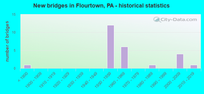
- New bridges - historical statistics
- 1Before 1900
- 121950-1959
- 61960-1969
- 11980-1989
- 42000-2009
- 12010-2019

- Reconstructed bridges - Historical Statistics
- 31980-1989
- 11990-1999
- 52000-2009


- Bridge Condition - Deck
- 21.4%Very good
- 28.6%Good
- 28.6%Satisfactory
- 14.3%Fair
- 7.1%Poor

- Bridge Condition - Superstructure
- 7.1%Excellent
- 14.3%Very good
- 21.4%Good
- 42.9%Satisfactory
- 7.1%Fair
- 7.1%Poor

- Bridge Condition - Substructure
- 14.3%Very good
- 42.9%Good
- 14.3%Satisfactory
- 21.4%Fair
- 7.1%Poor

- Bridge Condition - Channel
- 30.0%Good
- 20.0%Satisfactory
- 20.0%Fair
- 30.0%Poor

- Bridge Condition - Culverts
- 50.0%Good
- 50.0%Fair
Find on map >> Show street view
Structure Number: 27209, Location: BET. TP & 309 30H7/3369E1 (Lat: 40.124014, Lng: -75.220047), Route carried "on" structure: State highway 73, Year Built: 1987, Status: Open, Structure Length: 2.38m (7.81ft), Average Daily Traffic: 15,027 (year 2020), Truck Traffic: 3%, Average Future Daily Traffic: 20,695 (year 2032), Design Load: HS 25 or greater, Features Intersected: WISSAHICKON CREEK, Facility Carried by Structure: SKIPPACK PIKE
Minimum Vertical Clearance: 30+ m (98+ ft), Kilometerpoint: 40.436, Lanes on structure: 2, Base Highway Network: Yes, Owner: State Highway Agency, Approaching Roadway Width: 12.8m (42.0ft), Skew: 1 degrees, Material/Design: Prestressed concrete, Design/Construction: Box Beam or Girders - Multiple, Number Of Spans In Main Unit: 1, Length of Maximum Span: 23.5m (77.1ft), Curb or Sidewalk Widths: Left: 0.2m (0.7ft), Right: 0.2m (0.7ft), Curb-To-Curb Width: 12.8m (42.0ft), Out-to-Out Width: 13.6m (44.6ft)
Condition: Deck: Satisfactory, Superstructure: Satisfactory, Substructure: Good, Channel: Fair, Inventory Rating: 47.2 metric tons, Method Used To Determine Inventory Rating: Load Factor (LF), Structural Evaluation: Equal to present minimum criteria, Deck Geometry: Somewhat better than minimum adequacy, Waterway Adequacy: Somewhat better than minimum adequacy, Approach Roadway Alignment: Equal to present desirable criteria, Length Of Structure Improvement: 3.10m (10.17ft), Designated Inspection Frequency: Every 48 months, Inspection Date: June 2021, Deck Structure Type: Concrete Cast-file-Place, Wearing Surface/Protective System: Wearing Surface: Monolithic Concrete, Deck Protection: Epoxy Coated Reinforcing
Find on map >> Show street view
Structure Number: 27212, Location: EAST OF PENNA 309 31A09 (Lat: 40.112617, Lng: -75.200192), Route carried "on" structure: State highway 73, Year Built: 1958, Status: Open, Structure Length: 1.13m (3.71ft), Average Daily Traffic: 13,417 (year 2022), Truck Traffic: 4%, Average Future Daily Traffic: 18,943 (year 2032), Design Load: HS 20, Features Intersected: BRANCH WISSAHICKON CREEK, Facility Carried by Structure: CHURCH ROAD
Minimum Vertical Clearance: 30+ m (98+ ft), Kilometerpoint: 42.659, Lanes on structure: 4, Base Highway Network: Yes, Owner: State Highway Agency, Approaching Roadway Width: 18.3m (60.0ft), Skew: 23 degrees, Material/Design: Concrete, Design/Construction: Tee Beam, Number Of Spans In Main Unit: 1, Length of Maximum Span: 11.0m (36.1ft), Curb or Sidewalk Widths: Left: 1.5m (4.9ft), Right: 1.5m (4.9ft), Curb-To-Curb Width: 20.0m (65.6ft), Out-to-Out Width: 24.2m (79.4ft)
Condition: Deck: Good, Superstructure: Satisfactory, Substructure: Fair, Channel: Poor, Operating Rating: 53.5 metric tons, Method Used To Determine Operating Rating: Load Factor (LF), Inventory Rating: 31.8 metric tons, Method Used To Determine Inventory Rating: Load Factor (LF), Structural Evaluation: Somewhat better than minimum adequacy, Deck Geometry: Better than present minimum criteria, Waterway Adequacy: Equal to present minimum criteria, Approach Roadway Alignment: Equal to present desirable criteria, Length Of Structure Improvement: 1.70m (5.58ft), Designated Inspection Frequency: Every 24 months, Inspection Date: September 2020, Bridge Improvement Cost: $114,000, Roadway Improvement Cost: $337,000, Total Project Cost: $1,542,000, Deck Structure Type: Concrete Cast-file-Place, Wearing Surface/Protective System: Wearing Surface: Bituminous
Find on map >> Show street view
Structure Number: 27364, Location: ENFIELD 31B11 (Lat: 40.101842, Lng: -75.193742), Route carried "on" structure: State highway 309, Year Built: 1960, Year Reconstructed: 2006, Status: Open, Structure Length: 4.66m (15.29ft), Average Daily Traffic: 109,851 (year 2022), Truck Traffic: 2%, Average Future Daily Traffic: 59,296 (year 2032), Design Load: HS 25 or greater, Features Intersected: PAPER MILL ROAD
Minimum Vertical Clearance: 30+ m (98+ ft), Kilometerpoint: 6.738, Lanes on structure: 2, Lanes under structure: 6, Base Highway Network: Yes, Owner: State Highway Agency, Approaching Roadway Width: 20.7m (67.9ft), Skew: 30 degrees, Material/Design: Steel continuous, Design/Construction: Stringer/Multi-beam, Number Of Spans In Main Unit: 3, Length of Maximum Span: 21.0m (68.9ft), Curb or Sidewalk Widths: Left: 0.2m (0.7ft), Right: 0.2m (0.7ft), Curb-To-Curb Width: 20.7m (67.9ft), Out-to-Out Width: 27.4m (89.9ft)
Condition: Deck: Very good, Superstructure: Very good, Substructure: Very good, Inventory Rating: 60.8 metric tons, Method Used To Determine Inventory Rating: Load Factor (LF), Structural Evaluation: Equal to present desirable criteria, Deck Geometry: Superior to present desirable criteria, Underclear: Meets minimum limits, Approach Roadway Alignment: Equal to present desirable criteria, Length Of Structure Improvement: 5.50m (18.04ft), Designated Inspection Frequency: Every 24 months, Inspection Date: September 2020, Deck Structure Type: Concrete Cast-file-Place, Wearing Surface/Protective System: Wearing Surface: Monolithic Concrete, Deck Protection: Epoxy Coated Reinforcing
Find on map >> Show street view
Structure Number: 27366, Location: FLOURTOWN 31A10/3369J3 (Lat: 40.106428, Lng: -75.197803), Route carried "on" structure: State highway 309, Year Built: 1960, Year Reconstructed: 2006, Status: Open, Structure Length: 4.51m (14.80ft), Average Daily Traffic: 109,851 (year 2022), Truck Traffic: 2%, Average Future Daily Traffic: 59,296 (year 2032), Design Load: HL 93, Features Intersected: HAWS LANE
Minimum Vertical Clearance: 30+ m (98+ ft), Kilometerpoint: 7.596, Lanes on structure: 3, Lanes under structure: 2, Base Highway Network: Yes, Owner: State Highway Agency, Approaching Roadway Width: 20.7m (67.9ft), Skew: 33 degrees, Material/Design: Steel continuous, Design/Construction: Stringer/Multi-beam, Number Of Spans In Main Unit: 3, Length of Maximum Span: 21.6m (70.9ft), Curb or Sidewalk Widths: Left: 0.2m (0.7ft), Right: 0.2m (0.7ft), Curb-To-Curb Width: 20.7m (67.9ft), Out-to-Out Width: 21.6m (70.9ft)
Condition: Deck: Good, Superstructure: Good, Substructure: Good, Operating Rating: 88.0 metric tons, Method Used To Determine Operating Rating: Load Factor (LF), Inventory Rating: 52.6 metric tons, Method Used To Determine Inventory Rating: Load Factor (LF), Structural Evaluation: Better than present minimum criteria, Deck Geometry: Superior to present desirable criteria, Underclear: Meets minimum limits, Approach Roadway Alignment: Equal to present desirable criteria, Length Of Structure Improvement: 5.30m (17.39ft), Designated Inspection Frequency: Every 24 months, Inspection Date: August 2020, Deck Structure Type: Concrete Cast-file-Place, Wearing Surface/Protective System: Wearing Surface: Monolithic Concrete, Deck Protection: Epoxy Coated Reinforcing
Find on map >> Show street view
Structure Number: 27368, Location: ENFIELD 31A09 (Lat: 40.112372, Lng: -75.200578), Route carried "on" structure: State highway 309, Year Built: 1958, Year Reconstructed: 2006, Status: Open, Structure Length: 1.28m (4.20ft), Average Daily Traffic: 48,002 (year 2022), Truck Traffic: 3%, Average Future Daily Traffic: 60,532 (year 2032), Design Load: HL 93, Features Intersected: BRANCH WISSAHICKON CREEK
Minimum Vertical Clearance: 30+ m (98+ ft), Kilometerpoint: 7.596, Lanes on structure: 4, Base Highway Network: Yes, Owner: State Highway Agency, Approaching Roadway Width: 24.4m (80.1ft), Skew: 30 degrees, Material/Design: Concrete, Design/Construction: Arch - Deck, Number Of Spans In Main Unit: 1, Length of Maximum Span: 12.8m (42.0ft), Curb-To-Curb Width: 26.7m (87.6ft), Out-to-Out Width: 28.2m (92.5ft)
Condition: Deck: Very good, Superstructure: Good, Substructure: Good, Channel: Good, Operating Rating: 61.7 metric tons, Method Used To Determine Operating Rating: Field evaluation and documented engineering judgment, Inventory Rating: 37.2 metric tons, Method Used To Determine Inventory Rating: Field evaluation and documented engineering judgment, Structural Evaluation: Better than present minimum criteria, Deck Geometry: Superior to present desirable criteria, Waterway Adequacy: Superior to present desirable criteria, Approach Roadway Alignment: Equal to present desirable criteria, Length Of Structure Improvement: 2.00m (6.56ft), Designated Inspection Frequency: Every 24 months, Inspection Date: September 2020, Deck Structure Type: Concrete Cast-file-Place, Wearing Surface/Protective System: Wearing Surface: Monolithic Concrete, Deck Protection: Epoxy Coated Reinforcing
Find on map >> Show street view
Structure Number: 27369, Location: ENFIELD@RT73 31A09/3369H2 (Lat: 40.112936, Lng: -75.200850), Route carried "on" structure: State highway 309, Year Built: 1958, Year Reconstructed: 2006, Status: Open, Structure Length: 8.84m (29.00ft), Average Daily Traffic: 48,002 (year 2022), Truck Traffic: 3%, Average Future Daily Traffic: 60,532 (year 2032), Design Load: HS 20, Features Intersected: CHURCH ROAD
Minimum Vertical Clearance: 30+ m (98+ ft), Kilometerpoint: 8.348, Lanes on structure: 2, Lanes under structure: 4, Base Highway Network: Yes, Owner: State Highway Agency, Approaching Roadway Width: 19.5m (64.0ft), Skew: 35 degrees, Material/Design: Steel continuous, Design/Construction: Stringer/Multi-beam, Number Of Spans In Main Unit: 3, Length of Maximum Span: 41.5m (136.2ft), Curb or Sidewalk Widths: Left: 0.2m (0.7ft), Right: 0.2m (0.7ft), Curb-To-Curb Width: 19.5m (64.0ft), Out-to-Out Width: 28.3m (92.8ft)
Condition: Deck: Fair, Superstructure: Very good, Substructure: Good, Operating Rating: 77.1 metric tons, Method Used To Determine Operating Rating: Load Factor (LF), Inventory Rating: 46.3 metric tons, Method Used To Determine Inventory Rating: Load Factor (LF), Structural Evaluation: Better than present minimum criteria, Deck Geometry: Superior to present desirable criteria, Underclear: High priority of corrective action, Approach Roadway Alignment: Equal to present desirable criteria, Length Of Structure Improvement: 9.80m (32.15ft), Designated Inspection Frequency: Every 24 months, Inspection Date: Febuary 2021, Bridge Improvement Cost: $51,000, Roadway Improvement Cost: $149,000, Total Project Cost: $683,000, Deck Structure Type: Concrete Cast-file-Place, Wearing Surface/Protective System: Wearing Surface: Monolithic Concrete, Deck Protection: Epoxy Coated Reinforcing
Find on map >> Show street view
Structure Number: 27618, Location: SOUTH OF PENNA-73 30J09 (Lat: 40.111356, Lng: -75.214192), Route carried "on" structure: State highway , Year Built: 1961, Status: Open, Structure Length: 1.34m (4.40ft), Average Daily Traffic: 13,544 (year 2022), Truck Traffic: 2%, Average Future Daily Traffic: 18,523 (year 2032), Design Load: H 20, Features Intersected: BRANCH WISSAHICKON CREEK, Facility Carried by Structure: BETHLEHEM PIKE
Minimum Vertical Clearance: 30+ m (98+ ft), Kilometerpoint: 2.892, Lanes on structure: 2, Owner: State Highway Agency, Approaching Roadway Width: 13.4m (44.0ft), Skew: 20 degrees, Material/Design: Concrete, Design/Construction: Tee Beam, Number Of Spans In Main Unit: 1, Length of Maximum Span: 12.8m (42.0ft), Curb or Sidewalk Widths: Left: 1.5m (4.9ft), Right: 1.5m (4.9ft), Curb-To-Curb Width: 13.4m (44.0ft), Out-to-Out Width: 15.8m (51.8ft)
Condition: Deck: Fair, Superstructure: Fair, Substructure: Fair, Channel: Fair, Operating Rating: 59.9 metric tons, Method Used To Determine Operating Rating: Load Factor (LF), Inventory Rating: 35.4 metric tons, Method Used To Determine Inventory Rating: Load Factor (LF), Structural Evaluation: Somewhat better than minimum adequacy, Deck Geometry: Equal to present minimum criteria, Waterway Adequacy: Equal to present minimum criteria, Approach Roadway Alignment: Equal to present desirable criteria, Length Of Structure Improvement: 2.00m (6.56ft), Designated Inspection Frequency: Every 24 months, Inspection Date: July 2020, Deck Structure Type: Concrete Cast-file-Place, Wearing Surface/Protective System: Wearing Surface: Bituminous
Find on map >> Show street view
Structure Number: 27651, Location: ERDENHEIM 30K13/3369G6 (Lat: 40.088833, Lng: -75.209156), Route carried "on" structure: State highway , Year Built: 1957, Status: Open, Structure Length: 0.61m (2.00ft), Average Daily Traffic: 19,773 (year 2022), Truck Traffic: 2%, Average Future Daily Traffic: 16,227 (year 2032), Design Load: H 20, Features Intersected: BRANCH WISSAHICKON CREEK, Facility Carried by Structure: PAPER MILL ROAD
Minimum Vertical Clearance: 30+ m (98+ ft), Kilometerpoint: 0.000, Lanes on structure: 3, Owner: State Highway Agency, Approaching Roadway Width: 11.9m (39.0ft), Material/Design: Concrete, Design/Construction: Culvert, Number Of Spans In Main Unit: 1, Length of Maximum Span: 6.1m (20.0ft)
Condition: Channel: Poor, Culverts: Fair, Operating Rating: 75.3 metric tons, Method Used To Determine Operating Rating: Field evaluation and documented engineering judgment, Inventory Rating: 37.2 metric tons, Method Used To Determine Inventory Rating: Field evaluation and documented engineering judgment, Structural Evaluation: Somewhat better than minimum adequacy, Waterway Adequacy: Superior to present desirable criteria, Approach Roadway Alignment: Equal to present desirable criteria, Length Of Structure Improvement: 1.30m (4.27ft), Designated Inspection Frequency: Every 24 months, Inspection Date: December 2019
Find on map >> Show street view
Structure Number: 27948, Location: 1/4 Mi W Beth Pk 3369-E2 (Lat: 40.112900, Lng: -75.219206), Route carried "on" structure: City street , Year Built: 1884, Year Reconstructed: 1986, Status: Posted for load, Structure Length: 5.58m (18.31ft), Average Daily Traffic: 5,864 (year 2013), Average Future Daily Traffic: 6,054 (year 2018), Features Intersected: WISSAHICKON CREEK, Facility Carried by Structure: VALLEY GREEN ROAD
Minimum Vertical Clearance: 30+ m (98+ ft), Kilometerpoint: 0.000, Lanes on structure: 2, Owner: County Highway Agency, Approaching Roadway Width: 6.1m (20.0ft), Material/Design: Steel, Design/Construction: Truss - Thru, Number Of Spans In Main Unit: 3, Length of Maximum Span: 17.4m (57.1ft), Curb-To-Curb Width: 5.7m (18.7ft), Out-to-Out Width: 5.9m (19.4ft)
Condition: Deck: Poor, Superstructure: Poor, Substructure: Poor, Channel: Poor, Operating Rating: 10.9 metric tons, Method Used To Determine Operating Rating: Load Factor (LF), Inventory Rating: 4.5 metric tons, Method Used To Determine Inventory Rating: Load Factor (LF), Structural Evaluation: High priority of replacement, Deck Geometry: High priority of replacement, Waterway Adequacy: High priority of corrective action, Approach Roadway Alignment: High priority of corrective action, Bridge Posting: Required (Relationship of Operating Rating to Maximum Legal Load: > 39.9% below), Length Of Structure Improvement: 5.30m (17.39ft), Designated Inspection Frequency: Every 24 months, Critical Feature Inspection Frequency: Every 12 months, Other Special Inspection Frequency: Every 12 months, Inspection Date: July 2020, Critical Feature Inspection Date: July 2021, Other Special Inspection Date: July 2021, Bridge Improvement Cost: $93,000, Roadway Improvement Cost: $275,000, Total Project Cost: $1,260,000, Deck Structure Type: Closed Grating, Wearing Surface/Protective System: Wearing Surface: Bituminous
Find on map >> Show street view
Structure Number: 2804, Location: .12 MI NE SR 73 3369-J2 (Lat: 40.112758, Lng: -75.196794), Route carried "on" structure: City street , Year Built: 1957, Year Reconstructed: 2002, Status: Open, Structure Length: 0.70m (2.30ft), Average Daily Traffic: 1,720 (year 2012), Average Future Daily Traffic: 2,320 (year 2032), Design Load: H 20, Features Intersected: SUNNYBROOK CREEK, Facility Carried by Structure: WEST GARDEN ROAD
Minimum Vertical Clearance: 30+ m (98+ ft), Kilometerpoint: 0.000, Lanes on structure: 2, Owner: Town or Township Highway Agency, Approaching Roadway Width: 9.1m (29.9ft), Material/Design: Prestressed concrete, Design/Construction: Box Beam or Girders - Multiple, Number Of Spans In Main Unit: 1, Length of Maximum Span: 6.4m (21.0ft), Curb or Sidewalk Widths: Left: 2.2m (7.2ft), Right: 2.2m (7.2ft), Curb-To-Curb Width: 9.3m (30.5ft), Out-to-Out Width: 14.8m (48.6ft)
Condition: Deck: Satisfactory, Superstructure: Satisfactory, Substructure: Satisfactory, Channel: Satisfactory, Operating Rating: 71.7 metric tons, Method Used To Determine Operating Rating: Load Factor (LF), Inventory Rating: 42.6 metric tons, Method Used To Determine Inventory Rating: Load Factor (LF), Structural Evaluation: Equal to present minimum criteria, Deck Geometry: Somewhat better than minimum adequacy, Waterway Adequacy: Equal to present desirable criteria, Approach Roadway Alignment: Equal to present desirable criteria, Length Of Structure Improvement: 1.30m (4.27ft), Designated Inspection Frequency: Every 24 months, Inspection Date: May 2020, Deck Structure Type: Other, Wearing Surface/Protective System: Wearing Surface: Bituminous
Find on map >> Show street view
Structure Number: 28177, Location: FT WASHINGTON STATE PARK (Lat: 40.124686, Lng: -75.229142), Route carried "on" structure: State highway , Year Built: 1954, Year Reconstructed: 1993, Status: Open, Structure Length: 4.94m (16.21ft), Average Daily Traffic: 6,688 (year 2022), Truck Traffic: 6%, Average Future Daily Traffic: 5,266 (year 2030), Design Load: HS 20, Features Intersected: PA TPK (I-276), Facility Carried by Structure: SR 3014, LR 46102
Minimum Vertical Clearance: 30+ m (98+ ft), Kilometerpoint: 6.857, Lanes on structure: 2, Lanes under structure: 6, Owner: State Toll Authority, Approaching Roadway Width: 7.3m (24.0ft), Skew: 3 degrees, Material/Design: Steel, Design/Construction: Girder and Floorbeam System, Number Of Spans In Main Unit: 1, Length of Maximum Span: 47.2m (154.9ft), Curb or Sidewalk Widths: Left: 0.2m (0.7ft), Right: 0.2m (0.7ft), Curb-To-Curb Width: 9.1m (29.9ft), Out-to-Out Width: 11.0m (36.1ft)
Condition: Deck: Good, Superstructure: Satisfactory, Substructure: Satisfactory, Operating Rating: 77.1 metric tons, Method Used To Determine Operating Rating: Load Factor (LF), Inventory Rating: 46.3 metric tons, Method Used To Determine Inventory Rating: Load Factor (LF), Structural Evaluation: Equal to present minimum criteria, Deck Geometry: High priority of corrective action, Underclear: High priority of corrective action, Approach Roadway Alignment: Equal to present minimum criteria, Length Of Structure Improvement: 5.90m (19.36ft), Designated Inspection Frequency: Every 24 months, Critical Feature Inspection Frequency: Every 24 months, Inspection Date: July 2020, Critical Feature Inspection Date: July 2020, Bridge Improvement Cost: $55,000, Roadway Improvement Cost: $161,000, Total Project Cost: $739,000, Deck Structure Type: Concrete Cast-file-Place, Wearing Surface/Protective System: Wearing Surface: Latex Concrete
Find on map >> Show street view
Structure Number: 28181, Location: NEAR FORT WASHINGTON (Lat: 40.127808, Lng: -75.217558), Route carried "on" structure: Interstate 276, Year Built: 1954, Year Reconstructed: 1986, Status: Open, Structure Length: 5.64m (18.50ft), Average Daily Traffic: 74,921 (year 2001), Truck Traffic: 14%, Average Future Daily Traffic: 103,041 (year 2030), Design Load: HS 20, Features Intersected: SR 2018 BETH.PIKE
Minimum Vertical Clearance: 30+ m (98+ ft), Kilometerpoint: 0.000, Lanes on structure: 6, Lanes under structure: 2, Base Highway Network: Yes, Toll: On toll road, Owner: State Toll Authority, Approaching Roadway Width: 32.3m (106.0ft), Skew: 31 degrees, Material/Design: Steel, Design/Construction: Stringer/Multi-beam, Number Of Spans In Main Unit: 3, Length of Maximum Span: 25.6m (84.0ft), Curb or Sidewalk Widths: Left: 0.2m (0.7ft), Right: 0.2m (0.7ft), Curb-To-Curb Width: 31.7m (104.0ft), Out-to-Out Width: 33.5m (109.9ft)
Condition: Deck: Good, Superstructure: Satisfactory, Substructure: Fair, Operating Rating: 61.7 metric tons, Method Used To Determine Operating Rating: Load Factor (LF), Inventory Rating: 37.2 metric tons, Method Used To Determine Inventory Rating: Load Factor (LF), Structural Evaluation: Somewhat better than minimum adequacy, Deck Geometry: Superior to present desirable criteria, Underclear: High priority of corrective action, Approach Roadway Alignment: Equal to present desirable criteria, Length Of Structure Improvement: 6.40m (21.00ft), Designated Inspection Frequency: Every 24 months, Inspection Date: June 2021, Bridge Improvement Cost: $51,000, Roadway Improvement Cost: $149,000, Total Project Cost: $683,000, Deck Structure Type: Concrete Cast-file-Place, Wearing Surface/Protective System: Wearing Surface: Latex Concrete
Find on map >> Show street view
Structure Number: 28299, Location: CHURCH RD.INTERCH. 31A09 (Lat: 40.112131, Lng: -75.201017), Route carried "on" structure: State highway , Year Built: 1958, Year Reconstructed: 2006, Status: Open, Structure Length: 1.49m (4.89ft), Average Daily Traffic: 3,740 (year 2022), Truck Traffic: 7%, Average Future Daily Traffic: 3,805 (year 2032), Design Load: HS 20, Features Intersected: BRANCH OF WISSAHICKON CR, Facility Carried by Structure: RAMP J (309 SB)
Minimum Vertical Clearance: 30+ m (98+ ft), Kilometerpoint: 0.000, Lanes on structure: 1, Base Highway Network: Yes, Owner: State Highway Agency, Approaching Roadway Width: 9.1m (29.9ft), Skew: 1 degrees, Material/Design: Concrete, Design/Construction: Tee Beam, Number Of Spans In Main Unit: 1, Length of Maximum Span: 14.0m (45.9ft), Curb or Sidewalk Widths: Left: 0.2m (0.7ft), Right: 0.2m (0.7ft), Curb-To-Curb Width: 9.1m (29.9ft), Out-to-Out Width: 10.4m (34.1ft)
Condition: Deck: Satisfactory, Superstructure: Satisfactory, Substructure: Good, Channel: Good, Operating Rating: 70.8 metric tons, Method Used To Determine Operating Rating: Load Factor (LF), Inventory Rating: 42.6 metric tons, Method Used To Determine Inventory Rating: Load Factor (LF), Structural Evaluation: Equal to present minimum criteria, Deck Geometry: Meets minimum limits, Waterway Adequacy: Superior to present desirable criteria, Approach Roadway Alignment: Equal to present desirable criteria, Length Of Structure Improvement: 2.10m (6.89ft), Designated Inspection Frequency: Every 24 months, Inspection Date: April 2021, Deck Structure Type: Concrete Cast-file-Place, Wearing Surface/Protective System: Wearing Surface: Bituminous
Find on map >> Show street view
Structure Number: 43974, Location: CHURCH RD. INTERCH. 31A09 (Lat: 40.111989, Lng: -75.200094), Route carried "on" structure: Ramp State highway , Year Built: 2006, Status: Open, Structure Length: 0.70m (2.30ft), Average Daily Traffic: 3,128 (year 2022), Truck Traffic: 7%, Average Future Daily Traffic: 3,236 (year 2032), Design Load: H 15, Features Intersected: BRANCH OF WISSAHICKON CR, Facility Carried by Structure: RAMP K
Minimum Vertical Clearance: 30+ m (98+ ft), Kilometerpoint: 0.000, Lanes on structure: 1, Base Highway Network: Yes, Owner: State Highway Agency, Approaching Roadway Width: 8.8m (28.9ft), Skew: 4 degrees, Material/Design: Concrete, Design/Construction: Culvert, Number Of Spans In Main Unit: 1, Length of Maximum Span: 7.0m (23.0ft)
Condition: Channel: Good, Culverts: Good, Inventory Rating: 86.2 metric tons, Method Used To Determine Inventory Rating: Load Factor (LF), Structural Evaluation: Better than present minimum criteria, Waterway Adequacy: Superior to present desirable criteria, Approach Roadway Alignment: Equal to present desirable criteria, Designated Inspection Frequency: Every 24 months, Inspection Date: March 2020
Find on map >> Show street view
Structure Number: 44124, Location: FT WASHNGTN 30K08/3369H01 (Lat: 40.120117, Lng: -75.204317), Route carried "on" structure: State highway , Year Built: 2006, Status: Open, Structure Length: 3.60m (11.81ft), Average Daily Traffic: 3,360 (year 2022), Truck Traffic: 4%, Average Future Daily Traffic: 5,033 (year 2032), Design Load: HS 25 or greater, Features Intersected: TR-309 BY-PASS, Facility Carried by Structure: VALLEY GREEN ROAD
Minimum Vertical Clearance: 30+ m (98+ ft), Kilometerpoint: 0.000, Lanes on structure: 2, Lanes under structure: 4, Owner: State Highway Agency, Approaching Roadway Width: 14.6m (47.9ft), Skew: 3 degrees, Material/Design: Steel, Design/Construction: Stringer/Multi-beam, Number Of Spans In Main Unit: 1, Length of Maximum Span: 34.1m (111.9ft), Curb or Sidewalk Widths: Left: 0.2m (0.7ft), Right: 0.2m (0.7ft), Curb-To-Curb Width: 14.6m (47.9ft), Out-to-Out Width: 14.7m (48.2ft)
Condition: Deck: Satisfactory, Superstructure: Good, Substructure: Good, Inventory Rating: 65.3 metric tons, Method Used To Determine Inventory Rating: Load Factor (LF), Structural Evaluation: Better than present minimum criteria, Deck Geometry: Superior to present desirable criteria, Underclear: Meets minimum limits, Approach Roadway Alignment: Equal to present desirable criteria, Designated Inspection Frequency: Every 24 months, Inspection Date: Febuary 2021, Deck Structure Type: Concrete Cast-file-Place, Wearing Surface/Protective System: Wearing Surface: Monolithic Concrete, Deck Protection: Epoxy Coated Reinforcing
Find on map >> Show street view
Structure Number: 48369, Location: 3369-G3 ADC 2008 (Lat: 40.111003, Lng: -75.207258), Route carried "on" structure: City street , Year Built: 2013, Status: Open, Structure Length: 1.68m (5.51ft), Average Daily Traffic: 6,716 (year 2017), Truck Traffic: 1%, Average Future Daily Traffic: 8,000 (year 2037), Design Load: HL 93, Features Intersected: SUNNYBROOK CREEK, Facility Carried by Structure: EAST MILL ROAD
Minimum Vertical Clearance: 30+ m (98+ ft), Kilometerpoint: 0.000, Lanes on structure: 2, Owner: Town or Township Highway Agency, Approaching Roadway Width: 10.7m (35.1ft), Material/Design: Prestressed concrete, Design/Construction: Box Beam or Girders - Single/Spread, Number Of Spans In Main Unit: 1, Length of Maximum Span: 16.2m (53.1ft), Curb or Sidewalk Widths: Left: 1.7m (5.6ft), Right: 1.7m (5.6ft), Curb-To-Curb Width: 10.7m (35.1ft), Out-to-Out Width: 14.8m (48.6ft)
Condition: Deck: Very good, Superstructure: Excellent, Substructure: Very good, Channel: Satisfactory, Operating Rating: 43.1 metric tons, Method Used To Determine Operating Rating: Assigned ratings based on Load and Resistance Factor Design (LRFD) reported by rating factor (RF) using HL93 loadings, Inventory Rating: 33.0 metric tons, Method Used To Determine Inventory Rating: Assigned ratings based on Load and Resistance Factor Design (LRFD) reported by rating factor (RF) using HL93 loadings, Structural Evaluation: Equal to present desirable criteria, Deck Geometry: Meets minimum limits, Waterway Adequacy: Better than present minimum criteria, Approach Roadway Alignment: Equal to present desirable criteria, Designated Inspection Frequency: Every 24 months, Inspection Date: November 2019, Deck Structure Type: Concrete Cast-file-Place, Wearing Surface/Protective System: Wearing Surface: Monolithic Concrete, Membrane: Other, Deck Protection: Epoxy Coated Reinforcing
Find on map >> Show street view
Structure Number: 27364, Location: ENFIELD 31B11 (Lat: 40.101842, Lng: -75.193742), Route carried "under" structure: State highway , Year Built: 1960, Structure Length: 0. m, Average Daily Traffic: 2,718 (year 2012), Truck Traffic: 5%, Features Intersected: PAPER MILL ROAD, Facility Carried by Structure: PA 309 BY-PASS
Minimum Vertical Clearance: 4.70m (15.42ft), Kilometerpoint: 2.269, Lanes on structure: 2, Lanes under structure: 4, Material/Design: Steel continuous, Design/Construction: Stringer/Multi-beam, Length of Maximum Span: 21.0m (68.9ft)
Find on map >> Show street view
Structure Number: 27364, Location: ENFIELD 31B11 (Lat: 40.101842, Lng: -75.193742), Route carried "under" structure: State highway , Year Built: 1960, Structure Length: 0. m, Average Daily Traffic: 6,462 (year 2022), Truck Traffic: 5%, Features Intersected: PAPER MILL ROAD, Facility Carried by Structure: PA 309 BY-PASS
Minimum Vertical Clearance: 4.82m (15.81ft), Kilometerpoint: 2.037, Lanes on structure: 2, Lanes under structure: 2, Material/Design: Steel continuous, Design/Construction: Stringer/Multi-beam, Length of Maximum Span: 21.0m (68.9ft)
Find on map >> Show street view
Structure Number: 27366, Location: FLOURTOWN 31A10/3369J3 (Lat: 40.106428, Lng: -75.197803), Route carried "under" structure: County highway , Year Built: 1960, Structure Length: 0. m, Average Daily Traffic: 2,000 (year 1980), Features Intersected: HAWS LANE, Facility Carried by Structure: PA 309 BYPASS
Minimum Vertical Clearance: 4.27m (14.01ft), Kilometerpoint: 0.000, Lanes on structure: 3, Lanes under structure: 2, Material/Design: Steel continuous, Design/Construction: Stringer/Multi-beam, Length of Maximum Span: 21.6m (70.9ft)
Find on map >> Show street view
Structure Number: 27369, Location: ENFIELD@RT73 31A09/3369H2 (Lat: 40.112936, Lng: -75.200850), Route carried "under" structure: State highway 73, Year Built: 1958, Structure Length: 0. m, Average Daily Traffic: 4,930 (year 2022), Truck Traffic: 4%, Features Intersected: CHURCH ROAD, Facility Carried by Structure: PA 309 BY-PASS
Minimum Vertical Clearance: 4.57m (14.99ft), Kilometerpoint: 42.659, Lanes on structure: 2, Lanes under structure: 2, Material/Design: Steel continuous, Design/Construction: Stringer/Multi-beam, Length of Maximum Span: 41.5m (136.2ft)
Find on map >> Show street view
Structure Number: 27369, Location: ENFIELD@RT73 31A09/3369H2 (Lat: 40.112936, Lng: -75.200850), Route carried "under" structure: State highway 73, Year Built: 1958, Structure Length: 0. m, Average Daily Traffic: 8,487 (year 2022), Truck Traffic: 5%, Features Intersected: CHURCH ROAD, Facility Carried by Structure: PA 309 BY-PASS
Minimum Vertical Clearance: 4.67m (15.32ft), Kilometerpoint: 42.659, Lanes on structure: 2, Lanes under structure: 2, Material/Design: Steel continuous, Design/Construction: Stringer/Multi-beam, Length of Maximum Span: 41.5m (136.2ft)
Find on map >> Show street view
Structure Number: 28177, Location: FT WASHINGTON STATE PARK (Lat: 40.124686, Lng: -75.229142), Route carried "under" structure: Interstate 276, Year Built: 1954, Structure Length: 0. m, Average Daily Traffic: 120,317 (year 2004), Truck Traffic: 10%, Features Intersected: PA TPK (I-276), Facility Carried by Structure: SR 3014, LR 46102
Minimum Vertical Clearance: 4.50m (14.76ft), Kilometerpoint: 0.000, Lanes on structure: 2, Lanes under structure: 6, Material/Design: Steel, Design/Construction: Girder and Floorbeam System, Length of Maximum Span: 47.2m (154.9ft)
Find on map >> Show street view
Structure Number: 28181, Location: NEAR FORT WASHINGTON (Lat: 40.127808, Lng: -75.217558), Route carried "under" structure: State highway , Year Built: 1954, Structure Length: 0. m, Average Daily Traffic: 7,485 (year 2021), Truck Traffic: 6%, Features Intersected: SR 2018 BETH.PIKE, Facility Carried by Structure: PA TPK (I-276)
Minimum Vertical Clearance: 5.51m (18.08ft), Kilometerpoint: 4.455, Lanes on structure: 6, Lanes under structure: 2, Material/Design: Steel, Design/Construction: Stringer/Multi-beam, Length of Maximum Span: 25.6m (84.0ft)
Find on map >> Show street view
Structure Number: 44124, Location: FT WASHNGTN 30K08/3369H01 (Lat: 40.120117, Lng: -75.204317), Route carried "under" structure: State highway 309, Year Built: 2006, Structure Length: 0. m, Average Daily Traffic: 23,357 (year 2022), Truck Traffic: 3%, Features Intersected: TR-309 BY-PASS, Facility Carried by Structure: VALLEY GREEN ROAD
Minimum Vertical Clearance: 5.29m (17.36ft), Kilometerpoint: 9.249, Lanes on structure: 2, Lanes under structure: 2, Material/Design: Steel, Design/Construction: Stringer/Multi-beam, Length of Maximum Span: 34.1m (111.9ft)
Find on map >> Show street view
Structure Number: 44124, Location: FT WASHNGTN 30K08/3369H01 (Lat: 40.120117, Lng: -75.204317), Route carried "under" structure: State highway 309, Year Built: 2006, Structure Length: 0. m, Average Daily Traffic: 24,645 (year 2022), Truck Traffic: 3%, Features Intersected: TR-309 BY-PASS, Facility Carried by Structure: VALLEY GREEN ROAD
Minimum Vertical Clearance: 5.02m (16.47ft), Kilometerpoint: 9.242, Lanes on structure: 2, Lanes under structure: 2, Material/Design: Steel, Design/Construction: Stringer/Multi-beam, Length of Maximum Span: 34.1m (111.9ft)