Bridge Statistics for Fontana, Kansas (KS)
Condition, Traffic, Stress, Structural Evaluation, Project Costs
- National Bridge Inventory (NBI) Statistics
- 15Number of bridges
- 177ft / 54.3mTotal length
- $483,000Total costs
- 7,493Total average daily traffic
- 698Total average daily truck traffic
- 14,457Total future (year 2037) average daily traffic
- National Bridge Inventory (NBI) Registered Bridges for Fontana
- No street view available for this location
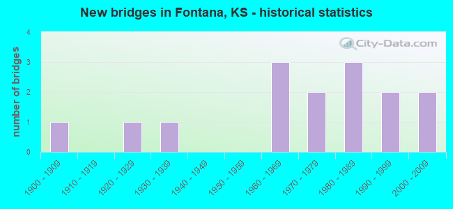
- New bridges - historical statistics
- 11900-1909
- 11920-1929
- 11930-1939
- 31960-1969
- 21970-1979
- 31980-1989
- 21990-1999
- 22000-2009

- Bridge Condition - Deck
- 27.3%Very good
- 45.5%Good
- 27.3%Satisfactory

- Bridge Condition - Superstructure
- 18.2%Very good
- 54.5%Good
- 18.2%Satisfactory
- 9.1%Poor

- Bridge Condition - Substructure
- 36.4%Very good
- 27.3%Good
- 36.4%Satisfactory

- Bridge Condition - Channel
- 21.4%Very good
- 21.4%Good
- 28.6%Satisfactory
- 21.4%Fair
- 7.1%Poor

- Bridge Condition - Culverts
- 75.0%Good
- 25.0%Fair
Find on map >> Show street view
Structure Number: 540019, Location: 2.5E 0.8N OF CADMUS (Lat: 38.356642, Lng: -94.853517), Route carried "on" structure: County highway 403, Year Built: 1971, Status: Open, Structure Length: 4.43m (14.53ft), Average Daily Traffic: 751 (year 2006), Truck Traffic: 10%, Average Future Daily Traffic: 840 (year 2037), Design Load: H 15, Features Intersected: ELM CREEK
Minimum Vertical Clearance: 30.47m (99.97ft), Kilometerpoint: 0.000, Lanes on structure: 2, Owner: County Highway Agency, Approaching Roadway Width: 7.3m (24.0ft), Material/Design: Concrete continuous, Design/Construction: Tee Beam, Number Of Spans In Main Unit: 3, Length of Maximum Span: 16.8m (55.1ft), Curb-To-Curb Width: 8.5m (27.9ft), Out-to-Out Width: 9.1m (29.9ft)
Condition: Deck: Good, Superstructure: Good, Substructure: Very good, Channel: Satisfactory, Operating Rating: 13.7 metric tons, Method Used To Determine Operating Rating: Load Factor (LF), Inventory Rating: 8.2 metric tons, Method Used To Determine Inventory Rating: Load Factor (LF), Structural Evaluation: High priority of corrective action, Deck Geometry: Somewhat better than minimum adequacy, Waterway Adequacy: Better than present minimum criteria, Approach Roadway Alignment: Equal to present desirable criteria, Bridge Posting: Required (Relationship of Operating Rating to Maximum Legal Load: > 39.9% below), Designated Inspection Frequency: Every 24 months, Inspection Date: January 2022, Deck Structure Type: Concrete Cast-file-Place, Wearing Surface/Protective System: Wearing Surface: Bituminous
Find on map >> Show street view
Structure Number: 54002, Location: 2.5E 1.8N OF CADMUS (Lat: 38.370750, Lng: -94.853333), Route carried "on" structure: County highway 403, Year Built: 1971, Status: Open, Structure Length: 0.71m (2.33ft), Average Daily Traffic: 751 (year 2006), Truck Traffic: 10%, Average Future Daily Traffic: 845 (year 2037), Design Load: H 20, Features Intersected: TRIB. TO ELM CREEK
Minimum Vertical Clearance: 30.47m (99.97ft), Kilometerpoint: 0.000, Lanes on structure: 2, Owner: County Highway Agency, Approaching Roadway Width: 7.3m (24.0ft), Skew: 4 degrees, Material/Design: Concrete, Design/Construction: Culvert, Number Of Spans In Main Unit: 2, Length of Maximum Span: 3.4m (11.2ft)
Condition: Channel: Good, Culverts: Good, Operating Rating: 48.4 metric tons, Method Used To Determine Operating Rating: Load Factor (LF), Inventory Rating: 28.1 metric tons, Method Used To Determine Inventory Rating: Load Factor (LF), Structural Evaluation: Better than present minimum criteria, Waterway Adequacy: Better than present minimum criteria, Approach Roadway Alignment: Equal to present desirable criteria, Designated Inspection Frequency: Every 24 months, Inspection Date: January 2022
Find on map >> Show street view
Structure Number: 61023, Location: 1.2S OF FONTANA (Lat: 38.401603, Lng: -94.853314), Route carried "on" structure: County highway 403, Year Built: 1983, Status: Open, Structure Length: 0.61m (2.00ft), Average Daily Traffic: 999 (year 2011), Truck Traffic: 10%, Average Future Daily Traffic: 2,410 (year 2041), Design Load: H 20, Features Intersected: TRIB. TO MIDDLE CREEK, Facility Carried by Structure: HEDGE LANE
Minimum Vertical Clearance: 30.47m (99.97ft), Kilometerpoint: 1.386, Lanes on structure: 2, Owner: County Highway Agency, Approaching Roadway Width: 7.6m (24.9ft), Material/Design: Concrete, Design/Construction: Culvert, Number Of Spans In Main Unit: 1, Length of Maximum Span: 6.1m (20.0ft), Curb-To-Curb Width: 8.8m (28.9ft), Out-to-Out Width: 9.0m (29.5ft)
Condition: Channel: Very good, Culverts: Good, Operating Rating: 42.6 metric tons, Method Used To Determine Operating Rating: Allowable Stress (AS), Inventory Rating: 25.4 metric tons, Method Used To Determine Inventory Rating: Allowable Stress (AS), Structural Evaluation: Equal to present minimum criteria, Deck Geometry: Somewhat better than minimum adequacy, Waterway Adequacy: Equal to present desirable criteria, Approach Roadway Alignment: Equal to present minimum criteria, Designated Inspection Frequency: Every 24 months, Inspection Date: June 2021, Wearing Surface/Protective System: Wearing Surface: Bituminous
Find on map >> Show street view
Structure Number: 61024, Location: 11.4S 1.3E OF PAOLA (Lat: 38.406419, Lng: -94.853339), Route carried "on" structure: County highway 403, Year Built: 1969, Year Reconstructed: 2012, Status: Open, Structure Length: 5.47m (17.95ft), Average Daily Traffic: 999 (year 2011), Truck Traffic: 10%, Average Future Daily Traffic: 2,410 (year 2041), Design Load: HS 20+Mod, Features Intersected: MIDDLE CREEK, Facility Carried by Structure: Hedge Lane Rd
Minimum Vertical Clearance: 30.47m (99.97ft), Kilometerpoint: 1.931, Lanes on structure: 2, Owner: County Highway Agency, Approaching Roadway Width: 7.3m (24.0ft), Material/Design: Steel continuous, Design/Construction: Stringer/Multi-beam, Number Of Spans In Main Unit: 3, Length of Maximum Span: 20.7m (67.9ft), Curb-To-Curb Width: 8.6m (28.2ft), Out-to-Out Width: 9.2m (30.2ft)
Condition: Deck: Very good, Superstructure: Good, Substructure: Very good, Channel: Good, Operating Rating: 62.6 metric tons, Method Used To Determine Operating Rating: Load Factor (LF), Inventory Rating: 39.0 metric tons, Method Used To Determine Inventory Rating: Load Factor (LF), Structural Evaluation: Better than present minimum criteria, Deck Geometry: Somewhat better than minimum adequacy, Waterway Adequacy: Equal to present desirable criteria, Approach Roadway Alignment: Equal to present minimum criteria, Designated Inspection Frequency: Every 24 months, Inspection Date: June 2021, Deck Structure Type: Concrete Cast-file-Place, Wearing Surface/Protective System: Deck Protection: Epoxy Coated Reinforcing
Find on map >> Show street view
Structure Number: 61025, Location: 8.8S 1.3E OF PAOLA (Lat: 38.443594, Lng: -94.853669), Route carried "on" structure: County highway 403, Year Built: 1987, Status: Posted for load, Structure Length: 8.48m (27.82ft), Average Daily Traffic: 1,220 (year 2011), Truck Traffic: 10%, Average Future Daily Traffic: 2,864 (year 2041), Design Load: HS 20, Features Intersected: BURLINGTON NORTHERN R.R., Facility Carried by Structure: Hedge Lane Rd
Minimum Vertical Clearance: 30.47m (99.97ft), Kilometerpoint: 6.119, Lanes on structure: 2, Owner: County Highway Agency, Approaching Roadway Width: 11.6m (38.1ft), Material/Design: Steel continuous, Design/Construction: Stringer/Multi-beam, Number Of Spans In Main Unit: 3, Length of Maximum Span: 32.6m (107.0ft), Curb-To-Curb Width: 8.5m (27.9ft), Out-to-Out Width: 9.1m (29.9ft)
Condition: Deck: Satisfactory, Superstructure: Good, Substructure: Satisfactory, Operating Rating: 41.7 metric tons, Method Used To Determine Operating Rating: Allowable Stress (AS), Inventory Rating: 23.6 metric tons, Method Used To Determine Inventory Rating: Allowable Stress (AS), Structural Evaluation: Equal to present minimum criteria, Deck Geometry: Somewhat better than minimum adequacy, Underclear: Superior to present desirable criteria, Approach Roadway Alignment: Equal to present minimum criteria, Designated Inspection Frequency: Every 24 months, Inspection Date: June 2021, Deck Structure Type: Concrete Cast-file-Place, Wearing Surface/Protective System: Deck Protection: Epoxy Coated Reinforcing
Find on map >> Show street view
Structure Number: 61026, Location: 8.8S 1.3E OF PAOLA (Lat: 38.449889, Lng: -94.853692), Route carried "on" structure: County highway 403, Year Built: 1930, Status: Open, Structure Length: 0.85m (2.79ft), Average Daily Traffic: 1,220 (year 2011), Truck Traffic: 10%, Average Future Daily Traffic: 2,864 (year 2041), Features Intersected: TRIB. MARAIS DES CYGNES, Facility Carried by Structure: Hedge Lane Rd
Minimum Vertical Clearance: 30.47m (99.97ft), Kilometerpoint: 6.825, Lanes on structure: 2, Owner: County Highway Agency, Approaching Roadway Width: 7.0m (23.0ft), Material/Design: Concrete, Design/Construction: Tee Beam, Number Of Spans In Main Unit: 1, Length of Maximum Span: 8.2m (26.9ft), Curb-To-Curb Width: 7.4m (24.3ft), Out-to-Out Width: 8.2m (26.9ft)
Condition: Deck: Satisfactory, Superstructure: Satisfactory, Substructure: Satisfactory, Channel: Poor, Operating Rating: 45.4 metric tons, Method Used To Determine Operating Rating: Allowable Stress (AS), Inventory Rating: 27.2 metric tons, Method Used To Determine Inventory Rating: Allowable Stress (AS), Structural Evaluation: Equal to present minimum criteria, Deck Geometry: Meets minimum limits, Waterway Adequacy: Better than present minimum criteria, Approach Roadway Alignment: Equal to present minimum criteria, Length Of Structure Improvement: 1.22m (4.00ft), Designated Inspection Frequency: Every 24 months, Inspection Date: June 2021, Bridge Improvement Cost: $150,000, Roadway Improvement Cost: $95,000, Total Project Cost: $250,000, Deck Structure Type: Concrete Cast-file-Place, Wearing Surface/Protective System: Wearing Surface: Bituminous
Find on map >> Show street view
Structure Number: 61042, Location: 1.5N 2.0E OF FONTANA (Lat: 38.449364, Lng: -94.797842), Route carried "on" structure: County highway 1023, Year Built: 1980, Status: Open, Structure Length: 12.04m (39.50ft), Average Daily Traffic: 73 (year 2011), Average Future Daily Traffic: 92 (year 2041), Design Load: H 20, Features Intersected: MARAIS DES CYGNES RIVER, Facility Carried by Structure: Ridgeview Rd
Minimum Vertical Clearance: 30.47m (99.97ft), Kilometerpoint: 7.245, Lanes on structure: 2, Owner: County Highway Agency, Approaching Roadway Width: 9.8m (32.2ft), Skew: 4 degrees, Material/Design: Steel continuous, Design/Construction: Stringer/Multi-beam, Number Of Spans In Main Unit: 3, Length of Maximum Span: 45.7m (149.9ft), Curb-To-Curb Width: 7.9m (25.9ft), Out-to-Out Width: 8.5m (27.9ft)
Condition: Deck: Good, Superstructure: Very good, Substructure: Good, Channel: Fair, Operating Rating: 73.5 metric tons, Method Used To Determine Operating Rating: Allowable Stress (AS), Inventory Rating: 47.2 metric tons, Method Used To Determine Inventory Rating: Allowable Stress (AS), Structural Evaluation: Better than present minimum criteria, Deck Geometry: Equal to present minimum criteria, Waterway Adequacy: Equal to present desirable criteria, Approach Roadway Alignment: Equal to present desirable criteria, Designated Inspection Frequency: Every 24 months, Inspection Date: May 2021, Deck Structure Type: Concrete Cast-file-Place
Find on map >> Show street view
Structure Number: 61044, Location: 11.0S 0.3W OF PAOLA (Lat: 38.417922, Lng: -94.884464), Route carried "on" structure: County highway 1024, Year Built: 1968, Status: Open, Structure Length: 1.07m (3.51ft), Average Daily Traffic: 438 (year 2011), Truck Traffic: 10%, Average Future Daily Traffic: 619 (year 2041), Design Load: H 20, Features Intersected: HASHPUCKNEY CREEK, Facility Carried by Structure: W 391st Street
Minimum Vertical Clearance: 30.47m (99.97ft), Kilometerpoint: 1.416, Lanes on structure: 2, Owner: County Highway Agency, Approaching Roadway Width: 7.3m (24.0ft), Skew: 3 degrees, Material/Design: Concrete, Design/Construction: Culvert, Number Of Spans In Main Unit: 2, Length of Maximum Span: 5.2m (17.1ft), Curb-To-Curb Width: 9.8m (32.2ft), Out-to-Out Width: 10.8m (35.4ft)
Condition: Channel: Fair, Culverts: Fair, Operating Rating: 62.6 metric tons, Method Used To Determine Operating Rating: Allowable Stress (AS), Inventory Rating: 38.1 metric tons, Method Used To Determine Inventory Rating: Allowable Stress (AS), Structural Evaluation: Somewhat better than minimum adequacy, Deck Geometry: Equal to present minimum criteria, Waterway Adequacy: Equal to present desirable criteria, Approach Roadway Alignment: Equal to present desirable criteria, Designated Inspection Frequency: Every 24 months, Inspection Date: June 2021, Wearing Surface/Protective System: Wearing Surface: Bituminous
Find on map >> Show street view
Structure Number: 541089305261, Location: 3.7W 0.7N OF LACYGNE (Lat: 38.357911, Lng: -94.839519), Route carried "on" structure: County highway , Year Built: 1969, Status: Open, Structure Length: 3.05m (10.01ft), Average Daily Traffic: 20 (year 2006), Average Future Daily Traffic: 25 (year 2037), Features Intersected: ELM CREEK, Facility Carried by Structure: LOCAL RD. 7A
Minimum Vertical Clearance: 30.47m (99.97ft), Kilometerpoint: 0.000, Lanes on structure: 2, Owner: County Highway Agency, Approaching Roadway Width: 5.7m (18.7ft), Material/Design: Prestressed concrete, Design/Construction: Tee Beam, Number Of Spans In Main Unit: 1, Length of Maximum Span: 29.9m (98.1ft), Curb-To-Curb Width: 7.3m (24.0ft), Out-to-Out Width: 7.8m (25.6ft)
Condition: Deck: Good, Superstructure: Satisfactory, Substructure: Satisfactory, Channel: Fair, Operating Rating: 32.4 metric tons, Method Used To Determine Operating Rating: Load Testing, Inventory Rating: 20.9 metric tons, Method Used To Determine Inventory Rating: Load Testing, Structural Evaluation: Equal to present minimum criteria, Deck Geometry: Equal to present minimum criteria, Waterway Adequacy: Equal to present minimum criteria, Approach Roadway Alignment: Equal to present minimum criteria, Designated Inspection Frequency: Every 24 months, Inspection Date: January 2022, Deck Structure Type: Concrete Cast-file-Place
Find on map >> Show street view
Structure Number: 61108170516, Location: 2.8E 1.0N OF BEAGLE (Lat: 38.432528, Lng: -94.905644), Route carried "on" structure: County highway , Year Built: 1920, Status: Open, Structure Length: 1.11m (3.64ft), Average Daily Traffic: 89 (year 2011), Average Future Daily Traffic: 63 (year 2041), Features Intersected: HUSHPUCKNEY CREEK, Facility Carried by Structure: 383rd Street
Minimum Vertical Clearance: 30.47m (99.97ft), Kilometerpoint: 0.000, Lanes on structure: 2, Owner: County Highway Agency, Approaching Roadway Width: 5.8m (19.0ft), Material/Design: Concrete, Design/Construction: Slab, Number Of Spans In Main Unit: 2, Length of Maximum Span: 5.2m (17.1ft), Curb-To-Curb Width: 5.8m (19.0ft), Out-to-Out Width: 5.8m (19.0ft)
Condition: Deck: Good, Superstructure: Good, Substructure: Good, Channel: Satisfactory, Operating Rating: 30.8 metric tons, Method Used To Determine Operating Rating: Allowable Stress (AS), Inventory Rating: 21.8 metric tons, Method Used To Determine Inventory Rating: Allowable Stress (AS), Structural Evaluation: Equal to present minimum criteria, Deck Geometry: Meets minimum limits, Waterway Adequacy: Equal to present minimum criteria, Approach Roadway Alignment: Equal to present desirable criteria, Designated Inspection Frequency: Every 24 months, Inspection Date: June 2021, Deck Structure Type: Concrete Cast-file-Place, Wearing Surface/Protective System: Wearing Surface: Gravel
Find on map >> Show street view
Structure Number: 611083005205, Location: 3.1W 2.0S OF FONTANA (Lat: 38.396253, Lng: -94.900689), Route carried "on" structure: County highway , Year Built: 2003, Status: Open, Structure Length: 1.00m (3.28ft), Average Daily Traffic: 20 (year 2011), Average Future Daily Traffic: 81 (year 2041), Design Load: HS 20, Features Intersected: TRIB. TO MIDDLE CREEK, Facility Carried by Structure: 403rd Street
Minimum Vertical Clearance: 30.47m (99.97ft), Kilometerpoint: 0.000, Lanes on structure: 2, Owner: County Highway Agency, Approaching Roadway Width: 6.7m (22.0ft), Material/Design: Concrete, Design/Construction: Culvert, Number Of Spans In Main Unit: 3, Length of Maximum Span: 3.0m (9.8ft), Curb-To-Curb Width: 8.6m (28.2ft), Out-to-Out Width: 9.2m (30.2ft)
Condition: Channel: Good, Culverts: Good, Operating Rating: 37.2 metric tons, Method Used To Determine Operating Rating: Allowable Stress (AS), Inventory Rating: 23.6 metric tons, Method Used To Determine Inventory Rating: Allowable Stress (AS), Structural Evaluation: Equal to present minimum criteria, Deck Geometry: Better than present minimum criteria, Waterway Adequacy: Equal to present desirable criteria, Approach Roadway Alignment: Equal to present desirable criteria, Designated Inspection Frequency: Every 24 months, Inspection Date: June 2021, Deck Structure Type: Concrete Cast-file-Place
Find on map >> Show street view
Structure Number: 611085005182, Location: 0.9N OF 339 ST ON HARMONY (Lat: 38.415483, Lng: -94.880997), Route carried "on" structure: County highway , Year Built: 1992, Status: Posted for load, Structure Length: 0.97m (3.18ft), Average Daily Traffic: 48 (year 2011), Average Future Daily Traffic: 54 (year 2041), Design Load: H 20, Features Intersected: TRIB. HUSHPUCKNEY CREEK, Facility Carried by Structure: Harmony Road
Minimum Vertical Clearance: 30.47m (99.97ft), Kilometerpoint: 0.000, Lanes on structure: 2, Owner: County Highway Agency, Approaching Roadway Width: 7.3m (24.0ft), Material/Design: Steel, Design/Construction: Stringer/Multi-beam, Number Of Spans In Main Unit: 1, Length of Maximum Span: 9.1m (29.9ft), Curb-To-Curb Width: 8.4m (27.6ft), Out-to-Out Width: 8.5m (27.9ft)
Condition: Deck: Very good, Superstructure: Good, Substructure: Very good, Channel: Satisfactory, Operating Rating: 28.1 metric tons, Method Used To Determine Operating Rating: Allowable Stress (AS), Inventory Rating: 17.2 metric tons, Method Used To Determine Inventory Rating: Allowable Stress (AS), Structural Evaluation: Somewhat better than minimum adequacy, Deck Geometry: Equal to present minimum criteria, Waterway Adequacy: Equal to present minimum criteria, Approach Roadway Alignment: Equal to present desirable criteria, Designated Inspection Frequency: Every 24 months, Inspection Date: June 2021, Deck Structure Type: Corrugated Steel, Wearing Surface/Protective System: Wearing Surface: Gravel
Find on map >> Show street view
Structure Number: 611093505101, Location: 0.9N 3.5W NEW LANCASTER (Lat: 38.474833, Lng: -94.798000), Route carried "on" structure: County highway , Year Built: 2006, Status: Open, Structure Length: 5.57m (18.27ft), Average Daily Traffic: 51 (year 2011), Average Future Daily Traffic: 74 (year 2041), Design Load: HS 20, Features Intersected: TRIB. MARAIS DES CYGNES, Facility Carried by Structure: Ridgeview Rd
Minimum Vertical Clearance: 30.47m (99.97ft), Kilometerpoint: 0.000, Lanes on structure: 2, Owner: County Highway Agency, Approaching Roadway Width: 6.7m (22.0ft), Material/Design: Concrete continuous, Design/Construction: Slab, Number Of Spans In Main Unit: 3, Length of Maximum Span: 22.0m (72.2ft), Curb-To-Curb Width: 8.6m (28.2ft), Out-to-Out Width: 9.2m (30.2ft)
Condition: Deck: Good, Superstructure: Very good, Substructure: Very good, Channel: Very good, Operating Rating: 68.9 metric tons, Method Used To Determine Operating Rating: Load Factor (LF), Inventory Rating: 41.3 metric tons, Method Used To Determine Inventory Rating: Load Factor (LF), Structural Evaluation: Equal to present desirable criteria, Deck Geometry: Better than present minimum criteria, Waterway Adequacy: Equal to present desirable criteria, Approach Roadway Alignment: Equal to present desirable criteria, Length Of Structure Improvement: 1.58m (5.18ft), Designated Inspection Frequency: Every 24 months, Inspection Date: June 2021, Bridge Improvement Cost: $42,000, Roadway Improvement Cost: $4,000, Total Project Cost: $63,000, Deck Structure Type: Concrete Cast-file-Place, Wearing Surface/Protective System: Deck Protection: Epoxy Coated Reinforcing
Find on map >> Show street view
Structure Number: 611097005145, Location: 1.5S 1.8W NEW LANCASTER (Lat: 38.439375, Lng: -94.768228), Route carried "on" structure: County highway , Year Built: 1907, Status: Posted for load, Structure Length: 3.69m (12.11ft), Average Daily Traffic: 21 (year 2015), Average Future Daily Traffic: 38 (year 2041), Features Intersected: MIDDLE CREEK, Facility Carried by Structure: 379th St
Minimum Vertical Clearance: 3.71m (12.17ft), Kilometerpoint: 0.000, Lanes on structure: 1, Owner: County Highway Agency, Approaching Roadway Width: 4.2m (13.8ft), Material/Design: Steel, Design/Construction: Truss - Thru, Number Of Spans In Main Unit: 1, Length of Maximum Span: 36.0m (118.1ft), Curb-To-Curb Width: 3.6m (11.8ft), Out-to-Out Width: 3.7m (12.1ft)
Condition: Deck: Satisfactory, Superstructure: Poor, Substructure: Satisfactory, Channel: Satisfactory, Operating Rating: 7.0 metric tons, Method Used To Determine Operating Rating: Load Factor (LF), Inventory Rating: 4.2 metric tons, Method Used To Determine Inventory Rating: Load Factor (LF), Structural Evaluation: High priority of replacement, Deck Geometry: High priority of replacement, Waterway Adequacy: Somewhat better than minimum adequacy, Approach Roadway Alignment: Meets minimum limits, Bridge Posting: Required (Relationship of Operating Rating to Maximum Legal Load: > 39.9% below), Length Of Structure Improvement: 12.19m (39.99ft), Designated Inspection Frequency: Every 24 months, Critical Feature Inspection Frequency: Every 24 months, Inspection Date: May 2021, Critical Feature Inspection Date: June 2021, Bridge Improvement Cost: $120,000, Roadway Improvement Cost: $495,000, Total Project Cost: $170,000, Deck Structure Type: Wood or Timber, Wearing Surface/Protective System: Wearing Surface: Wood or Timber
Find on map >> Show street view
Structure Number: 999900700610831, Location: .10 MI N OF LINN CO. LINE (Lat: 38.391111, Lng: -94.899167), Route carried "on" structure: State highway 7, Year Built: 1990, Status: Open, Structure Length: 5.26m (17.26ft), Average Daily Traffic: 793 (year 2020), Truck Traffic: 8%, Average Future Daily Traffic: 1,178 (year 2041), Design Load: HS 20, Features Intersected: MIDDLE CREEK
Minimum Vertical Clearance: 30.47m (99.97ft), Kilometerpoint: 0.241, Lanes on structure: 2, Owner: State Highway Agency, Approaching Roadway Width: 7.3m (24.0ft), Skew: 2 degrees, Material/Design: Prestressed concrete continuous, Design/Construction: Stringer/Multi-beam, Number Of Spans In Main Unit: 3, Length of Maximum Span: 24.4m (80.1ft), Curb-To-Curb Width: 11.0m (36.1ft), Out-to-Out Width: 11.6m (38.1ft)
Condition: Deck: Very good, Superstructure: Good, Substructure: Good, Channel: Very good, Operating Rating: 79.5 metric tons, Method Used To Determine Operating Rating: Load Factor (LF), Inventory Rating: 43.1 metric tons, Method Used To Determine Inventory Rating: Load Factor (LF), Structural Evaluation: Better than present minimum criteria, Deck Geometry: Better than present minimum criteria, Waterway Adequacy: Equal to present desirable criteria, Approach Roadway Alignment: Somewhat better than minimum adequacy, Length Of Structure Improvement: 17.27m (56.66ft), Designated Inspection Frequency: Every 24 months, Inspection Date: March 2020, Wearing Surface/Protective System: Wearing Surface: Monolithic Concrete, Deck Protection: Epoxy Coated Reinforcing