Bridge Statistics for Forest Park, Illinois (IL)
Condition, Traffic, Stress, Structural Evaluation, Project Costs
- National Bridge Inventory (NBI) Statistics
- 13Number of bridges
- 121ft / 36.6mTotal length
- $9,238,000Total costs
- 1,071,350Total average daily traffic
- 65,439Total average daily truck traffic
- National Bridge Inventory (NBI) Registered Bridges for Forest Park
- No street view available for this location
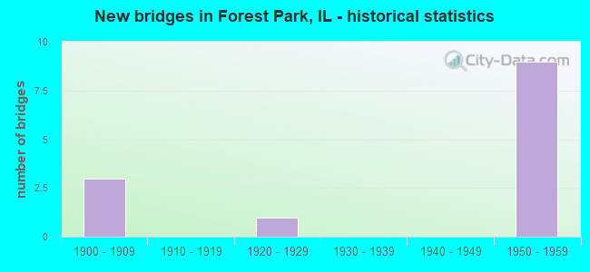
- New bridges - historical statistics
- 31900-1909
- 11920-1929
- 91950-1959

- Reconstructed bridges - Historical Statistics
- 21970-1979
- 11980-1989
- 11990-1999


- Bridge Condition - Deck
- 40.0%Satisfactory
- 40.0%Fair
- 20.0%Poor

- Bridge Condition - Superstructure
- 20.0%Good
- 40.0%Satisfactory
- 20.0%Fair
- 20.0%Serious

- Bridge Condition - Substructure
- 40.0%Satisfactory
- 60.0%Fair
Find on map >> Show street view
Structure Number: 16009, Location: 1.1 M W ILL 43 (Lat: 41.872106, Lng: -87.820850), Route carried "on" structure: Interstate 290, Year Built: 1958, Status: Open, Structure Length: 6.00m (19.69ft), Average Daily Traffic: 171,700 (year 2021), Truck Traffic: 6%, Average Future Daily Traffic: 209,502 (year 2032), Design Load: HS 20+Mod, Features Intersected: DES PLAINES RIVER
Minimum Vertical Clearance: 30+ m (98+ ft), Kilometerpoint: 33.345, Lanes on structure: 6, Base Highway Network: Yes, Owner: State Highway Agency, Approaching Roadway Width: 29.0m (95.1ft), Skew: 31 degrees, Material/Design: Steel continuous, Design/Construction: Stringer/Multi-beam, Number Of Spans In Main Unit: 2, Length of Maximum Span: 30.0m (98.4ft), Curb-To-Curb Width: 29.8m (97.8ft), Out-to-Out Width: 31.7m (104.0ft)
Condition: Deck: Fair, Superstructure: Good, Substructure: Fair, Channel: Good, Operating Rating: 97.2 metric tons, Method Used To Determine Operating Rating: Load Factor (LF) rating reported by rating factor (RF) method using MS18 loading, Inventory Rating: 54.8 metric tons, Method Used To Determine Inventory Rating: Load Factor (LF) rating reported by rating factor (RF) method using MS18 loading, Structural Evaluation: Somewhat better than minimum adequacy, Deck Geometry: Superior to present desirable criteria, Waterway Adequacy: Equal to present desirable criteria, Approach Roadway Alignment: Equal to present desirable criteria, Length Of Structure Improvement: 6.10m (20.01ft), Designated Inspection Frequency: Every 24 months, Inspection Date: Febuary 2020, Bridge Improvement Cost: $1,495,000, Roadway Improvement Cost: $150,000, Total Project Cost: $2,243,000, Deck Structure Type: Concrete Cast-file-Place, Wearing Surface/Protective System: Wearing Surface: Other, Deck Protection: Epoxy Coated Reinforcing
Find on map >> Show street view
Structure Number: 160311, Location: 0.5 M N IL 38 (Lat: 41.873917, Lng: -87.804528), Route carried "on" structure: State highway 43, Year Built: 1957, Year Reconstructed: 1998, Status: Open, Structure Length: 10.73m (35.20ft), Average Daily Traffic: 32,700 (year 2021), Truck Traffic: 5%, Average Future Daily Traffic: 34,608 (year 2032), Design Load: HS 20, Features Intersected: I-290, CTA, CSX RR
Minimum Vertical Clearance: 30+ m (98+ ft), Kilometerpoint: 41.246, Lanes on structure: 6, Lanes under structure: 6, Base Highway Network: Yes, Owner: State Highway Agency, Approaching Roadway Width: 14.0m (45.9ft), Skew: 30 degrees, Material/Design: Steel continuous, Design/Construction: Stringer/Multi-beam, Number Of Spans In Main Unit: 5, Length of Maximum Span: 19.9m (65.3ft), Curb or Sidewalk Widths: Left: 1.8m (5.9ft), Right: 1.8m (5.9ft), Curb-To-Curb Width: 22.9m (75.1ft), Out-to-Out Width: 27.5m (90.2ft)
Condition: Deck: Fair, Superstructure: Fair, Substructure: Fair, Operating Rating: 55.4 metric tons, Method Used To Determine Operating Rating: Load Factor (LF) rating reported by rating factor (RF) method using MS18 loading, Inventory Rating: 33.0 metric tons, Method Used To Determine Inventory Rating: Load Factor (LF) rating reported by rating factor (RF) method using MS18 loading, Structural Evaluation: Somewhat better than minimum adequacy, Deck Geometry: Meets minimum limits, Underclear: Meets minimum limits, Approach Roadway Alignment: Equal to present minimum criteria, Designated Inspection Frequency: Every 24 months, Inspection Date: March 2021, Deck Structure Type: Concrete Cast-file-Place, Wearing Surface/Protective System: Wearing Surface: Latex Concrete
Find on map >> Show street view
Structure Number: 160472, Location: 0.3M E OF 1ST AVE (Lat: 41.864581, Lng: -87.827200), Route carried "on" structure: Other road , Year Built: 1928, Year Reconstructed: 1986, Status: Open, Structure Length: 3.70m (12.14ft), Average Daily Traffic: 20,300 (year 2021), Truck Traffic: 3%, Average Future Daily Traffic: 37,080 (year 2032), Features Intersected: DES PLAINES RIVER, Facility Carried by Structure: ROOSEVELT RD
Minimum Vertical Clearance: 30+ m (98+ ft), Kilometerpoint: 7.709, Lanes on structure: 4, Base Highway Network: Yes, Owner: State Highway Agency, Approaching Roadway Width: 14.6m (47.9ft), Material/Design: Prestressed concrete continuous, Design/Construction: Stringer/Multi-beam, Number Of Spans In Main Unit: 2, Length of Maximum Span: 18.5m (60.7ft), Curb or Sidewalk Widths: Left: 1.5m (4.9ft), Right: 1.5m (4.9ft), Curb-To-Curb Width: 14.6m (47.9ft), Out-to-Out Width: 18.3m (60.0ft)
Condition: Deck: Satisfactory, Superstructure: Satisfactory, Substructure: Fair, Channel: Good, Operating Rating: 73.9 metric tons, Method Used To Determine Operating Rating: Load Factor (LF) rating reported by rating factor (RF) method using MS18 loading, Inventory Rating: 42.4 metric tons, Method Used To Determine Inventory Rating: Load Factor (LF) rating reported by rating factor (RF) method using MS18 loading, Structural Evaluation: Somewhat better than minimum adequacy, Deck Geometry: High priority of replacement, Waterway Adequacy: Equal to present desirable criteria, Approach Roadway Alignment: Equal to present desirable criteria, Length Of Structure Improvement: 4.51m (14.80ft), Designated Inspection Frequency: Every 24 months, Inspection Date: June 2021, Bridge Improvement Cost: $990,000, Roadway Improvement Cost: $99,000, Total Project Cost: $1,485,000, Deck Structure Type: Concrete Cast-file-Place, Wearing Surface/Protective System: Deck Protection: Epoxy Coated Reinforcing
Find on map >> Show street view
Structure Number: 160706, Location: 0.5 M W IL 43 (Lat: 41.873239, Lng: -87.815411), Route carried "on" structure: Other road , Year Built: 1957, Year Reconstructed: 1984, Status: Open, Structure Length: 4.27m (14.01ft), Average Daily Traffic: 16,800 (year 2021), Truck Traffic: 5%, Average Future Daily Traffic: 13,184 (year 2032), Design Load: HS 20, Features Intersected: I-290 IKE, Facility Carried by Structure: DES PLAINES AVE
Minimum Vertical Clearance: 30+ m (98+ ft), Kilometerpoint: 0.708, Lanes on structure: 5, Lanes under structure: 6, Owner: State Highway Agency, Approaching Roadway Width: 16.5m (54.1ft), Material/Design: Steel continuous, Design/Construction: Stringer/Multi-beam, Number Of Spans In Main Unit: 2, Length of Maximum Span: 25.3m (83.0ft), Curb or Sidewalk Widths: Left: 1.5m (4.9ft), Right: 1.5m (4.9ft), Curb-To-Curb Width: 16.5m (54.1ft), Out-to-Out Width: 20.1m (65.9ft)
Condition: Deck: Satisfactory, Superstructure: Satisfactory, Substructure: Satisfactory, Operating Rating: 53.1 metric tons, Method Used To Determine Operating Rating: Load Factor (LF) rating reported by rating factor (RF) method using MS18 loading, Inventory Rating: 32.1 metric tons, Method Used To Determine Inventory Rating: Load Factor (LF) rating reported by rating factor (RF) method using MS18 loading, Structural Evaluation: Equal to present minimum criteria, Deck Geometry: High priority of replacement, Underclear: High priority of replacement, Approach Roadway Alignment: Equal to present minimum criteria, Length Of Structure Improvement: 5.67m (18.60ft), Designated Inspection Frequency: Every 24 months, Inspection Date: July 2020, Bridge Improvement Cost: $1,350,000, Roadway Improvement Cost: $135,000, Total Project Cost: $2,025,000, Deck Structure Type: Concrete Cast-file-Place, Wearing Surface/Protective System: Deck Protection: Epoxy Coated Reinforcing
Find on map >> Show street view
Structure Number: 160995, Location: 0.2 M W IL 43 (Lat: 41.874061, Lng: -87.808178), Route carried "on" structure: Other road , Year Built: 1958, Year Reconstructed: 1984, Status: Open, Structure Length: 11.95m (39.21ft), Average Daily Traffic: 4,550 (year 2018), Truck Traffic: 8%, Average Future Daily Traffic: 5,159 (year 2032), Design Load: HS 20, Features Intersected: I-290, CTA, CSX RR, Facility Carried by Structure: CIRCLE AVE
Minimum Vertical Clearance: 30+ m (98+ ft), Kilometerpoint: 1.561, Lanes on structure: 2, Lanes under structure: 10, Owner: State Highway Agency, Approaching Roadway Width: 7.3m (24.0ft), Material/Design: Steel continuous, Design/Construction: Stringer/Multi-beam, Number Of Spans In Main Unit: 6, Length of Maximum Span: 25.6m (84.0ft), Curb or Sidewalk Widths: Left: 1.5m (4.9ft), Right: 1.5m (4.9ft), Curb-To-Curb Width: 7.9m (25.9ft), Out-to-Out Width: 11.6m (38.1ft)
Condition: Deck: Poor, Superstructure: Serious, Substructure: Satisfactory, Operating Rating: 70.3 metric tons, Method Used To Determine Operating Rating: Load Factor (LF) rating reported by rating factor (RF) method using MS18 loading, Inventory Rating: 42.1 metric tons, Method Used To Determine Inventory Rating: Load Factor (LF) rating reported by rating factor (RF) method using MS18 loading, Structural Evaluation: High priority of corrective action, Deck Geometry: High priority of corrective action, Underclear: High priority of replacement, Approach Roadway Alignment: Equal to present minimum criteria, Length Of Structure Improvement: 12.71m (41.70ft), Designated Inspection Frequency: Every 12 months, Inspection Date: July 2021, Bridge Improvement Cost: $2,323,000, Roadway Improvement Cost: $232,000, Total Project Cost: $3,485,000, Deck Structure Type: Concrete Cast-file-Place, Wearing Surface/Protective System: Wearing Surface: Other, Deck Protection: Epoxy Coated Reinforcing
Find on map >> Show street view
Structure Number: 160092, Location: 0.5 M W ILL 43 P20 (Lat: 41.873658, Lng: -87.813936), Route carried "under" structure: Interstate 290, Year Built: 1959, Structure Length: 0. m, Average Daily Traffic: 159,200 (year 2021), Truck Traffic: 6%, Features Intersected: I-290 IKE, Facility Carried by Structure: CTA
Minimum Vertical Clearance: 5.77m (18.93ft), Kilometerpoint: 33.940, Lanes under structure: 6, Material/Design: Steel continuous, Design/Construction: Girder and Floorbeam System, Length of Maximum Span: 26.2m (86.0ft)
Find on map >> Show street view
Structure Number: 160093, Location: 0.5 M W ILL 43 P20 (Lat: 41.873956, Lng: -87.812136), Route carried "under" structure: Interstate 290, Year Built: 1959, Structure Length: 0. m, Average Daily Traffic: 159,200 (year 2021), Truck Traffic: 6%, Features Intersected: I-290 IKE, Facility Carried by Structure: B&O RR
Minimum Vertical Clearance: 5.69m (18.67ft), Kilometerpoint: 34.085, Lanes under structure: 6, Material/Design: Steel continuous, Design/Construction: Stringer/Multi-beam, Length of Maximum Span: 18.6m (61.0ft)
Find on map >> Show street view
Structure Number: 16031, Location: 1 M N I290 P16,20 (Lat: 41.886917, Lng: -87.804961), Route carried "under" structure: State highway 43, Year Built: 1900, Structure Length: 0. m, Average Daily Traffic: 31,700 (year 2021), Truck Traffic: 5%, Features Intersected: ILL 43 (HARLEM AV), Facility Carried by Structure: CTA & UPRR
Minimum Vertical Clearance: 4.34m (14.24ft), Kilometerpoint: 42.695, Lanes under structure: 4, Material/Design: Prestressed concrete, Length of Maximum Span: 7.3m (24.0ft)
Find on map >> Show street view
Structure Number: 160311, Location: 0.5 M N IL 38 (Lat: 41.873500, Lng: -87.804514), Route carried "under" structure: Interstate 290, Year Built: 1957, Structure Length: 0. m, Average Daily Traffic: 141,200 (year 2021), Truck Traffic: 7%, Features Intersected: I-290, CTA, CSX RR, Facility Carried by Structure: IL 43 (HARLEM AVE
Minimum Vertical Clearance: 5.66m (18.57ft), Kilometerpoint: 34.729, Lanes on structure: 6, Lanes under structure: 6, Material/Design: Steel continuous, Design/Construction: Stringer/Multi-beam, Length of Maximum Span: 19.9m (65.3ft)
Find on map >> Show street view
Structure Number: 160703, Location: 0.1 M N I290 P20 (Lat: 41.874650, Lng: -87.815061), Route carried "under" structure: Other road , Year Built: 1900, Structure Length: 0. m, Average Daily Traffic: 16,800 (year 2021), Truck Traffic: 5%, Features Intersected: DES PLAINES AVE, Facility Carried by Structure: BOCT (WC) RR
Minimum Vertical Clearance: 4.39m (14.40ft), Kilometerpoint: 0.547, Lanes under structure: 4, Material/Design: Steel, Length of Maximum Span: 21.3m (69.9ft)
Find on map >> Show street view
Structure Number: 160705, Location: 0.05 M N I290 P20 (Lat: 41.873928, Lng: -87.815242), Route carried "under" structure: Other road , Year Built: 1900, Structure Length: 0. m, Average Daily Traffic: 16,800 (year 2021), Truck Traffic: 5%, Features Intersected: DES PLAINES AVE, Facility Carried by Structure: CTA
Minimum Vertical Clearance: 4.75m (15.58ft), Kilometerpoint: 0.628, Lanes under structure: 2, Material/Design: Steel, Length of Maximum Span: 20.7m (67.9ft)
Find on map >> Show street view
Structure Number: 160706, Location: 0.5 M W IL 43 (Lat: 41.873239, Lng: -87.815411), Route carried "under" structure: Interstate 290, Year Built: 1957, Structure Length: 0. m, Average Daily Traffic: 159,200 (year 2021), Truck Traffic: 6%, Features Intersected: I-290 IKE, Facility Carried by Structure: DES PLAINES AVE
Minimum Vertical Clearance: 4.60m (15.09ft), Kilometerpoint: 33.811, Lanes on structure: 5, Lanes under structure: 6, Material/Design: Steel continuous, Design/Construction: Stringer/Multi-beam, Length of Maximum Span: 25.3m (83.0ft)
Find on map >> Show street view
Structure Number: 160995, Location: 0.2 M W IL 43 (Lat: 41.873850, Lng: -87.808172), Route carried "under" structure: Interstate 290, Year Built: 1958, Structure Length: 0. m, Average Daily Traffic: 141,200 (year 2021), Truck Traffic: 7%, Features Intersected: I-290, CTA, CSX RR, Facility Carried by Structure: CIRCLE AVE
Minimum Vertical Clearance: 6.02m (19.75ft), Kilometerpoint: 34.600, Lanes on structure: 2, Lanes under structure: 10, Material/Design: Steel continuous, Design/Construction: Stringer/Multi-beam, Length of Maximum Span: 25.6m (84.0ft)