Bridge Statistics for Fort Morgan, Colorado (CO)
Condition, Traffic, Stress, Structural Evaluation, Project Costs
- National Bridge Inventory (NBI) Statistics
- 32Number of bridges
- 253ft / 77.2mTotal length
- $993,000Total costs
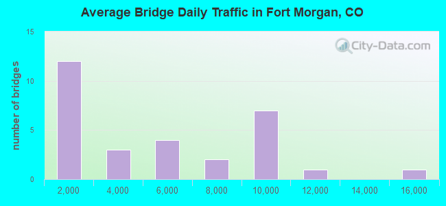
- 137,379Total average daily traffic
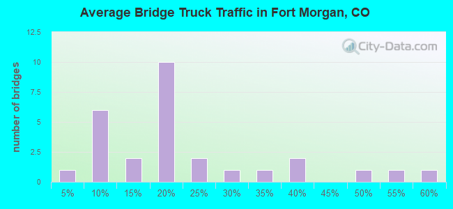
- 20,545Total average daily truck traffic
- National Bridge Inventory (NBI) Registered Bridges for Fort Morgan
- No street view available for this location
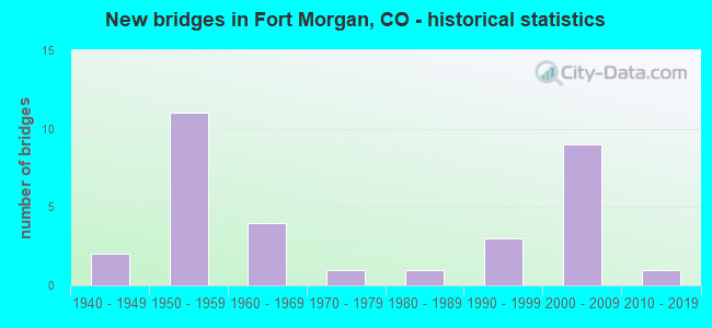
- New bridges - historical statistics
- 21940-1949
- 111950-1959
- 41960-1969
- 11970-1979
- 11980-1989
- 31990-1999
- 92000-2009
- 12010-2019
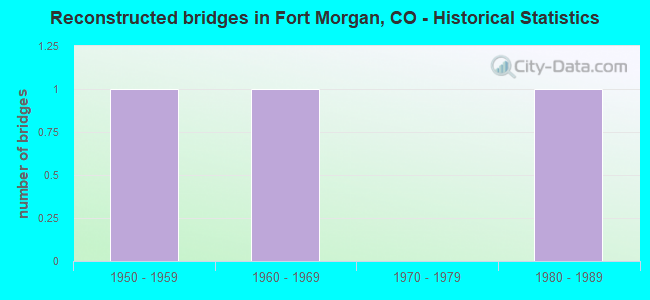
- Reconstructed bridges - Historical Statistics
- 11950-1959
- 11960-1969
- 01970-1979
- 11980-1989
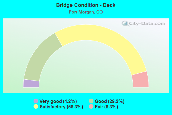
- Bridge Condition - Deck
- 4.2%Very good
- 29.2%Good
- 58.3%Satisfactory
- 8.3%Fair
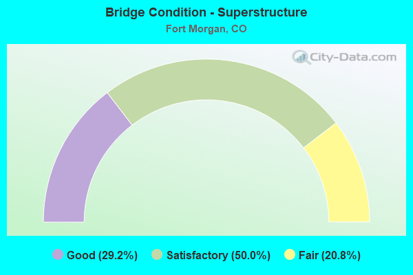
- Bridge Condition - Superstructure
- 29.2%Good
- 50.0%Satisfactory
- 20.8%Fair
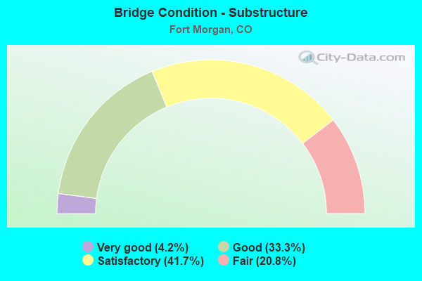
- Bridge Condition - Substructure
- 4.2%Very good
- 33.3%Good
- 41.7%Satisfactory
- 20.8%Fair
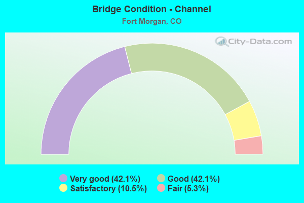
- Bridge Condition - Channel
- 42.1%Very good
- 42.1%Good
- 10.5%Satisfactory
- 5.3%Fair
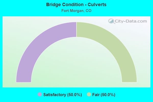
- Bridge Condition - Culverts
- 50.0%Satisfactory
- 50.0%Fair
Find on map >> Show street view
Structure Number: C-21-AN, Location: 3 MI NO FT MORGAN (Lat: 40.303789, Lng: -103.800700), Route carried "on" structure: State highway 52B, Year Built: 1967, Status: Open, Structure Length: 2.09m (6.86ft), Average Daily Traffic: 2,100 (year 2020), Truck Traffic: 12%, Average Future Daily Traffic: 2,856 (year 2040), Design Load: H 20, Features Intersected: RIVERSIDE CANAL, Facility Carried by Structure: SH 52 ML
Minimum Vertical Clearance: 30+ m (98+ ft), Kilometerpoint: 5.546, Lanes on structure: 2, Owner: State Highway Agency, Approaching Roadway Width: 7.9m (25.9ft), Skew: 3 degrees, Material/Design: Concrete, Design/Construction: Tee Beam, Number Of Spans In Main Unit: 3, Length of Maximum Span: 6.7m (22.0ft), Curb or Sidewalk Widths: Left: 0.4m (1.3ft), Right: 0.4m (1.3ft), Curb-To-Curb Width: 9.1m (29.9ft), Out-to-Out Width: 10.4m (34.1ft)
Condition: Deck: Satisfactory, Superstructure: Fair, Substructure: Satisfactory, Channel: Very good, Operating Rating: 51.7 metric tons, Method Used To Determine Operating Rating: Load Factor (LF), Inventory Rating: 31.0 metric tons, Method Used To Determine Inventory Rating: Load Factor (LF), Structural Evaluation: Somewhat better than minimum adequacy, Deck Geometry: Meets minimum limits, Waterway Adequacy: Equal to present desirable criteria, Approach Roadway Alignment: Equal to present desirable criteria, Designated Inspection Frequency: Every 24 months, Inspection Date: March 2021, Deck Structure Type: Other, Wearing Surface/Protective System: Wearing Surface: Bituminous
Find on map >> Show street view
Structure Number: C-21-AV, Location: 0.3 MI NO OF JCT SH 144 (Lat: 40.264908, Lng: -103.801247), Route carried "on" structure: State highway 52B, Year Built: 1951, Year Reconstructed: 1971, Status: Open, Structure Length: 1.34m (4.40ft), Average Daily Traffic: 5,800 (year 2020), Truck Traffic: 6%, Average Future Daily Traffic: 6,554 (year 2040), Design Load: H 20, Features Intersected: UPRR PLATTE,BEAVER CANAL, Facility Carried by Structure: SH 52 ML
Minimum Vertical Clearance: 30+ m (98+ ft), Kilometerpoint: 1.221, Lanes on structure: 4, Owner: State Highway Agency, Approaching Roadway Width: 19.5m (64.0ft), Skew: 1 degrees, Material/Design: Steel, Design/Construction: Stringer/Multi-beam, Number Of Spans In Main Unit: 1, Length of Maximum Span: 12.2m (40.0ft), Curb or Sidewalk Widths: Left: 0.6m (2.0ft), Right: 1.5m (4.9ft), Curb-To-Curb Width: 19.5m (64.0ft), Out-to-Out Width: 21.6m (70.9ft)
Condition: Deck: Satisfactory, Superstructure: Good, Substructure: Good, Channel: Good, Operating Rating: 36.0 metric tons, Method Used To Determine Operating Rating: Load Factor (LF), Inventory Rating: 21.6 metric tons, Method Used To Determine Inventory Rating: Load Factor (LF), Structural Evaluation: Somewhat better than minimum adequacy, Deck Geometry: Better than present minimum criteria, Waterway Adequacy: Equal to present desirable criteria, Approach Roadway Alignment: Equal to present desirable criteria, Length Of Structure Improvement: 1.34m (4.40ft), Designated Inspection Frequency: Every 24 months, Inspection Date: March 2021, Bridge Improvement Cost: $112,000, Roadway Improvement Cost: $11,000, Total Project Cost: $168,000, Deck Structure Type: Concrete Cast-file-Place, Wearing Surface/Protective System: Wearing Surface: Bituminous
Find on map >> Show street view
Structure Number: C-21-B, Location: 1.3 MI SW OF JCT SH 52 (Lat: 40.265497, Lng: -103.826228), Route carried "on" structure: Interstate 76A, Year Built: 1959, Status: Open, Structure Length: 5.70m (18.70ft), Average Daily Traffic: 8,000 (year 2020), Truck Traffic: 19%, Average Future Daily Traffic: 11,440 (year 2040), Design Load: HS 20+Mod, Features Intersected: SH 144 ML, Facility Carried by Structure: I 76 ML WBND
Minimum Vertical Clearance: 30+ m (98+ ft), Kilometerpoint: 126.733, Lanes on structure: 2, Lanes under structure: 2, Base Highway Network: Yes, Owner: State Highway Agency, Approaching Roadway Width: 12.8m (42.0ft), Skew: 15 degrees, Material/Design: Concrete continuous, Design/Construction: Tee Beam, Number Of Spans In Main Unit: 3, Length of Maximum Span: 22.9m (75.1ft), Curb or Sidewalk Widths: Left: 0.6m (2.0ft), Right: 0.6m (2.0ft), Curb-To-Curb Width: 12.8m (42.0ft), Out-to-Out Width: 14.0m (45.9ft)
Condition: Deck: Satisfactory, Superstructure: Satisfactory, Substructure: Satisfactory, Operating Rating: 35.7 metric tons, Method Used To Determine Operating Rating: Load Factor (LF), Inventory Rating: 21.4 metric tons, Method Used To Determine Inventory Rating: Load Factor (LF), Structural Evaluation: Somewhat better than minimum adequacy, Deck Geometry: Equal to present desirable criteria, Underclear: High priority of corrective action, Approach Roadway Alignment: Equal to present desirable criteria, Designated Inspection Frequency: Every 24 months, Inspection Date: January 2021, Deck Structure Type: Concrete Cast-file-Place, Wearing Surface/Protective System: Wearing Surface: Bituminous
Find on map >> Show street view
Structure Number: C-21-BA, Location: EAST FT. MORGAN EXIT (Lat: 40.263175, Lng: -103.772858), Route carried "on" structure: Interstate 76A, Year Built: 1959, Status: Open, Structure Length: 3.41m (11.19ft), Average Daily Traffic: 7,500 (year 2020), Truck Traffic: 17%, Average Future Daily Traffic: 10,350 (year 2040), Design Load: HS 20+Mod, Features Intersected: CR 20-BARLOW RD., Facility Carried by Structure: I 76 ML WBND
Minimum Vertical Clearance: 30+ m (98+ ft), Kilometerpoint: 131.292, Lanes on structure: 2, Lanes under structure: 2, Base Highway Network: Yes, Owner: State Highway Agency, Approaching Roadway Width: 11.6m (38.1ft), Skew: 10 degrees, Material/Design: Concrete continuous, Design/Construction: Tee Beam, Number Of Spans In Main Unit: 3, Length of Maximum Span: 13.4m (44.0ft), Curb or Sidewalk Widths: Left: 0.6m (2.0ft), Right: 0.6m (2.0ft), Curb-To-Curb Width: 11.6m (38.1ft), Out-to-Out Width: 12.8m (42.0ft)
Condition: Deck: Fair, Superstructure: Satisfactory, Substructure: Fair, Operating Rating: 65.2 metric tons, Method Used To Determine Operating Rating: Load Factor (LF), Inventory Rating: 39.0 metric tons, Method Used To Determine Inventory Rating: Load Factor (LF), Structural Evaluation: Somewhat better than minimum adequacy, Deck Geometry: Equal to present minimum criteria, Underclear: Meets minimum limits, Approach Roadway Alignment: Equal to present desirable criteria, Designated Inspection Frequency: Every 24 months, Inspection Date: June 2021, Deck Structure Type: Concrete Cast-file-Place, Wearing Surface/Protective System: Wearing Surface: Bituminous
Find on map >> Show street view
Structure Number: C-21-BB, Location: EAST FT MORGAN EXIT (Lat: 40.262931, Lng: -103.772867), Route carried "on" structure: Interstate 76A, Year Built: 1959, Status: Open, Structure Length: 3.41m (11.19ft), Average Daily Traffic: 7,500 (year 2020), Truck Traffic: 17%, Average Future Daily Traffic: 10,350 (year 2040), Design Load: HS 20+Mod, Features Intersected: CR 20-BARLOW ROAD, Facility Carried by Structure: I 76 ML EBND
Minimum Vertical Clearance: 30+ m (98+ ft), Kilometerpoint: 131.290, Lanes on structure: 2, Lanes under structure: 2, Base Highway Network: Yes, Owner: State Highway Agency, Approaching Roadway Width: 11.6m (38.1ft), Skew: 10 degrees, Material/Design: Concrete continuous, Design/Construction: Tee Beam, Number Of Spans In Main Unit: 3, Length of Maximum Span: 13.4m (44.0ft), Curb or Sidewalk Widths: Left: 0.6m (2.0ft), Right: 0.6m (2.0ft), Curb-To-Curb Width: 11.6m (38.1ft), Out-to-Out Width: 12.8m (42.0ft)
Condition: Deck: Fair, Superstructure: Fair, Substructure: Fair, Operating Rating: 65.0 metric tons, Method Used To Determine Operating Rating: Load Factor (LF), Inventory Rating: 38.9 metric tons, Method Used To Determine Inventory Rating: Load Factor (LF), Structural Evaluation: Somewhat better than minimum adequacy, Deck Geometry: Equal to present minimum criteria, Underclear: Somewhat better than minimum adequacy, Approach Roadway Alignment: Equal to present desirable criteria, Designated Inspection Frequency: Every 24 months, Inspection Date: June 2021, Deck Structure Type: Concrete Cast-file-Place, Wearing Surface/Protective System: Wearing Surface: Bituminous
Find on map >> Show street view
Structure Number: C-21-BE, Location: IN FT MORGAN (Lat: 40.268022, Lng: -103.801381), Route carried "on" structure: State highway 52B, Year Built: 1963, Status: Open, Structure Length: 29.64m (97.24ft), Average Daily Traffic: 5,800 (year 2020), Truck Traffic: 6%, Average Future Daily Traffic: 6,554 (year 2040), Design Load: HS 20, Features Intersected: SOUTH PLATTE RIVER, Facility Carried by Structure: SH 52 ML
Minimum Vertical Clearance: 30+ m (98+ ft), Kilometerpoint: 1.568, Lanes on structure: 2, Owner: State Highway Agency, Approaching Roadway Width: 19.5m (64.0ft), Material/Design: Prestressed concrete, Design/Construction: Stringer/Multi-beam, Number Of Spans In Main Unit: 20, Length of Maximum Span: 14.2m (46.6ft), Curb or Sidewalk Widths: Left: 0.6m (2.0ft), Right: 0.6m (2.0ft), Curb-To-Curb Width: 9.1m (29.9ft), Out-to-Out Width: 10.4m (34.1ft)
Condition: Deck: Satisfactory, Superstructure: Good, Substructure: Satisfactory, Channel: Satisfactory, Operating Rating: 64.0 metric tons, Method Used To Determine Operating Rating: Load Factor (LF), Inventory Rating: 35.1 metric tons, Method Used To Determine Inventory Rating: Load Factor (LF), Structural Evaluation: Equal to present minimum criteria, Deck Geometry: Meets minimum limits, Waterway Adequacy: Equal to present minimum criteria, Approach Roadway Alignment: Equal to present desirable criteria, Designated Inspection Frequency: Every 24 months, Inspection Date: March 2021, Deck Structure Type: Concrete Cast-file-Place, Wearing Surface/Protective System: Wearing Surface: Bituminous, Membrane: Preformed Fabric
Find on map >> Show street view
Structure Number: C-21-BG, Location: 0.4 MI E OF JCT SH 52 (Lat: 40.263147, Lng: -103.794086), Route carried "on" structure: Interstate 76A, Year Built: 1958, Status: Open, Structure Length: 1.08m (3.54ft), Average Daily Traffic: 15,000 (year 2020), Truck Traffic: 17%, Average Future Daily Traffic: 20,700 (year 2040), Design Load: HL 93, Features Intersected: UPPER PLATTE BEAVER DITC, Facility Carried by Structure: I 76 ML
Minimum Vertical Clearance: 30+ m (98+ ft), Kilometerpoint: 129.486, Lanes on structure: 4, Base Highway Network: Yes, Owner: State Highway Agency, Approaching Roadway Width: 23.2m (76.1ft), Skew: 24 degrees, Material/Design: Steel, Design/Construction: Culvert, Number Of Spans In Main Unit: 1, Length of Maximum Span: 10.8m (35.4ft), Out-to-Out Width: 62.3m (204.4ft)
Condition: Channel: Very good, Culverts: Satisfactory, Operating Rating: 96.9 metric tons, Method Used To Determine Operating Rating: Load and Resistance Factor Rating (LRFR) rating reported by rating factor(RF) method using HL-93 loadings, Inventory Rating: 96.6 metric tons, Method Used To Determine Inventory Rating: Load and Resistance Factor Rating (LRFR) rating reported by rating factor(RF) method using HL-93 loadings, Structural Evaluation: Equal to present minimum criteria, Waterway Adequacy: Equal to present desirable criteria, Approach Roadway Alignment: Equal to present desirable criteria, Designated Inspection Frequency: Every 24 months, Inspection Date: January 2021
Find on map >> Show street view
Structure Number: C-21-G, Location: .8 MI W of 52 FT MORGAN (Lat: 40.253942, Lng: -103.817211), Route carried "on" structure: US 34B, Year Built: 1940, Year Reconstructed: 1958, Status: Open, Structure Length: 1.68m (5.51ft), Average Daily Traffic: 3,200 (year 2020), Truck Traffic: 9%, Average Future Daily Traffic: 3,392 (year 2040), Design Load: HS 20, Features Intersected: FORT MORGAN CANAL, Facility Carried by Structure: US 34 ML
Minimum Vertical Clearance: 30+ m (98+ ft), Kilometerpoint: 5.893, Lanes on structure: 2, Base Highway Network: Yes, Owner: State Highway Agency, Approaching Roadway Width: 12.2m (40.0ft), Material/Design: Steel, Design/Construction: Stringer/Multi-beam, Number Of Spans In Main Unit: 1, Number Of Approach Spans: 2, Length of Maximum Span: 9.7m (31.8ft), Curb-To-Curb Width: 13.4m (44.0ft), Out-to-Out Width: 14.6m (47.9ft)
Condition: Deck: Satisfactory, Superstructure: Fair, Substructure: Fair, Channel: Very good, Operating Rating: 35.3 metric tons, Method Used To Determine Operating Rating: Load Factor (LF), Inventory Rating: 21.1 metric tons, Method Used To Determine Inventory Rating: Load Factor (LF), Structural Evaluation: Somewhat better than minimum adequacy, Deck Geometry: Better than present minimum criteria, Waterway Adequacy: Equal to present desirable criteria, Approach Roadway Alignment: Equal to present desirable criteria, Designated Inspection Frequency: Every 24 months, Inspection Date: November 2021, Deck Structure Type: Concrete Cast-file-Place, Wearing Surface/Protective System: Wearing Surface: Bituminous
Find on map >> Show street view
Structure Number: C-21-I, Location: 9.5 MI SW OF JCT SH 71 (Lat: 40.263978, Lng: -103.801686), Route carried "on" structure: Interstate 76A, Year Built: 1959, Status: Open, Structure Length: 4.63m (15.19ft), Average Daily Traffic: 8,000 (year 2020), Truck Traffic: 17%, Average Future Daily Traffic: 11,040 (year 2040), Design Load: HS 20, Features Intersected: SH 52 ML, Facility Carried by Structure: I 76 ML WBND
Minimum Vertical Clearance: 30+ m (98+ ft), Kilometerpoint: 128.831, Lanes on structure: 2, Lanes under structure: 4, Base Highway Network: Yes, Owner: State Highway Agency, Approaching Roadway Width: 11.6m (38.1ft), Skew: 11 degrees, Material/Design: Concrete continuous, Design/Construction: Tee Beam, Number Of Spans In Main Unit: 3, Length of Maximum Span: 18.3m (60.0ft), Curb or Sidewalk Widths: Left: 0.6m (2.0ft), Right: 0.6m (2.0ft), Curb-To-Curb Width: 9.1m (29.9ft), Out-to-Out Width: 10.4m (34.1ft)
Condition: Deck: Satisfactory, Superstructure: Satisfactory, Substructure: Satisfactory, Operating Rating: 39.9 metric tons, Method Used To Determine Operating Rating: Load Factor (LF), Inventory Rating: 23.6 metric tons, Method Used To Determine Inventory Rating: Load Factor (LF), Structural Evaluation: Somewhat better than minimum adequacy, Deck Geometry: High priority of replacement, Underclear: Meets minimum limits, Approach Roadway Alignment: Equal to present desirable criteria, Length Of Structure Improvement: 4.63m (15.19ft), Designated Inspection Frequency: Every 24 months, Inspection Date: January 2021, Bridge Improvement Cost: $186,000, Roadway Improvement Cost: $19,000, Total Project Cost: $279,000, Deck Structure Type: Concrete Cast-file-Place, Wearing Surface/Protective System: Wearing Surface: Bituminous
Find on map >> Show street view
Structure Number: C-21-M, Location: 1.3 MI E OF JCT SH 144 (Lat: 40.263742, Lng: -103.801692), Route carried "on" structure: Interstate 76A, Year Built: 1959, Status: Open, Structure Length: 4.63m (15.19ft), Average Daily Traffic: 8,000 (year 2020), Truck Traffic: 17%, Average Future Daily Traffic: 11,040 (year 2040), Design Load: HS 20+Mod, Features Intersected: SH 52 ML, Facility Carried by Structure: I 76 ML EBND
Minimum Vertical Clearance: 30+ m (98+ ft), Kilometerpoint: 128.836, Lanes on structure: 2, Lanes under structure: 2, Base Highway Network: Yes, Owner: State Highway Agency, Approaching Roadway Width: 11.6m (38.1ft), Skew: 11 degrees, Material/Design: Concrete continuous, Design/Construction: Tee Beam, Number Of Spans In Main Unit: 3, Length of Maximum Span: 18.3m (60.0ft), Curb or Sidewalk Widths: Left: 0.6m (2.0ft), Right: 0.6m (2.0ft), Curb-To-Curb Width: 9.1m (29.9ft), Out-to-Out Width: 10.4m (34.1ft)
Condition: Deck: Satisfactory, Superstructure: Fair, Substructure: Satisfactory, Operating Rating: 39.9 metric tons, Method Used To Determine Operating Rating: Load Factor (LF), Inventory Rating: 23.6 metric tons, Method Used To Determine Inventory Rating: Load Factor (LF), Structural Evaluation: Somewhat better than minimum adequacy, Deck Geometry: High priority of replacement, Underclear: Meets minimum limits, Approach Roadway Alignment: Equal to present desirable criteria, Length Of Structure Improvement: 4.66m (15.29ft), Designated Inspection Frequency: Every 24 months, Inspection Date: January 2021, Bridge Improvement Cost: $188,000, Roadway Improvement Cost: $19,000, Total Project Cost: $281,000, Deck Structure Type: Concrete Cast-file-Place, Wearing Surface/Protective System: Wearing Surface: Bituminous
Find on map >> Show street view
Structure Number: C-22-BU, Location: 4 MI EAST OF FT MORGAN (Lat: 40.266414, Lng: -103.734992), Route carried "on" structure: Interstate 76A, Year Built: 2005, Status: Open, Structure Length: 2.36m (7.74ft), Average Daily Traffic: 8,000 (year 2020), Truck Traffic: 16%, Average Future Daily Traffic: 10,800 (year 2040), Design Load: HL 93, Features Intersected: COUNTY ROAD 22, Facility Carried by Structure: I 76 ML WBND
Minimum Vertical Clearance: 30+ m (98+ ft), Kilometerpoint: 134.565, Lanes on structure: 2, Lanes under structure: 2, Base Highway Network: Yes, Owner: State Highway Agency, Approaching Roadway Width: 11.6m (38.1ft), Skew: 10 degrees, Material/Design: Prestressed concrete, Design/Construction: Stringer/Multi-beam, Number Of Spans In Main Unit: 1, Length of Maximum Span: 21.9m (71.9ft), Curb-To-Curb Width: 11.6m (38.1ft), Out-to-Out Width: 12.5m (41.0ft)
Condition: Deck: Good, Superstructure: Good, Substructure: Good, Operating Rating: 48.0 metric tons, Method Used To Determine Operating Rating: Load and Resistance Factor Rating (LRFR) rating reported by rating factor(RF) method using HL-93 loadings, Inventory Rating: 36.9 metric tons, Method Used To Determine Inventory Rating: Load and Resistance Factor Rating (LRFR) rating reported by rating factor(RF) method using HL-93 loadings, Structural Evaluation: Better than present minimum criteria, Deck Geometry: Somewhat better than minimum adequacy, Underclear: Equal to present minimum criteria, Approach Roadway Alignment: Equal to present desirable criteria, Designated Inspection Frequency: Every 24 months, Inspection Date: June 2021, Deck Structure Type: Concrete Precast Panels, Wearing Surface/Protective System: Wearing Surface: Bituminous, Membrane: Built-up, Deck Protection: Epoxy Coated Reinforcing
Find on map >> Show street view
Structure Number: C-22-BV, Location: 4 MI EAST OF FT MORGAN (Lat: 40.266658, Lng: -103.735083), Route carried "on" structure: Interstate 76A, Year Built: 2005, Status: Open, Structure Length: 2.36m (7.74ft), Average Daily Traffic: 8,000 (year 2020), Truck Traffic: 16%, Average Future Daily Traffic: 10,800 (year 2040), Design Load: HL 93, Features Intersected: COUNTY ROAD 22, Facility Carried by Structure: I76 ML EBND
Minimum Vertical Clearance: 30+ m (98+ ft), Kilometerpoint: 134.564, Lanes on structure: 2, Lanes under structure: 2, Base Highway Network: Yes, Owner: State Highway Agency, Approaching Roadway Width: 11.6m (38.1ft), Skew: 10 degrees, Material/Design: Prestressed concrete, Design/Construction: Stringer/Multi-beam, Number Of Spans In Main Unit: 1, Length of Maximum Span: 21.9m (71.9ft), Curb-To-Curb Width: 11.6m (38.1ft), Out-to-Out Width: 12.5m (41.0ft)
Condition: Deck: Good, Superstructure: Good, Substructure: Good, Operating Rating: 37.3 metric tons, Method Used To Determine Operating Rating: Load and Resistance Factor Rating (LRFR) rating reported by rating factor(RF) method using HL-93 loadings, Inventory Rating: 29.5 metric tons, Method Used To Determine Inventory Rating: Load and Resistance Factor Rating (LRFR) rating reported by rating factor(RF) method using HL-93 loadings, Structural Evaluation: Better than present minimum criteria, Deck Geometry: Somewhat better than minimum adequacy, Underclear: Better than present minimum criteria, Approach Roadway Alignment: Equal to present desirable criteria, Designated Inspection Frequency: Every 24 months, Inspection Date: June 2021, Deck Structure Type: Concrete Precast Panels, Wearing Surface/Protective System: Wearing Surface: Bituminous, Membrane: Built-up, Deck Protection: Epoxy Coated Reinforcing
Find on map >> Show street view
Structure Number: FTM-ACOMA-AVE, Location: 0.3 MI E of S WEST ST (Lat: 40.239628, Lng: -103.805264), Route carried "on" structure: City street , Year Built: 2016, Status: Open, Structure Length: 1.22m (4.00ft), Average Daily Traffic: 1,869 (year 2012), Truck Traffic: 2%, Average Future Daily Traffic: 2,729 (year 2032), Design Load: HL 93, Features Intersected: FT. MORGAN CANAL, Facility Carried by Structure: ACOMA AVE.
Minimum Vertical Clearance: 30+ m (98+ ft), Kilometerpoint: 0.898, Lanes on structure: 2, Owner: City or Municipal Highway Agency, Approaching Roadway Width: 13.1m (43.0ft), Material/Design: Steel, Design/Construction: Stringer/Multi-beam, Number Of Spans In Main Unit: 1, Length of Maximum Span: 11.0m (36.1ft), Curb or Sidewalk Widths: Left: 1.8m (5.9ft), Right: 1.8m (5.9ft), Curb-To-Curb Width: 13.1m (43.0ft), Out-to-Out Width: 16.8m (55.1ft)
Condition: Deck: Very good, Superstructure: Good, Substructure: Very good, Channel: Very good, Operating Rating: 39.9 metric tons, Method Used To Determine Operating Rating: Load and Resistance Factor Rating (LRFR) rating reported by rating factor(RF) method using HL-93 loadings, Inventory Rating: 30.5 metric tons, Method Used To Determine Inventory Rating: Load and Resistance Factor Rating (LRFR) rating reported by rating factor(RF) method using HL-93 loadings, Structural Evaluation: Better than present minimum criteria, Deck Geometry: Better than present minimum criteria, Waterway Adequacy: Better than present minimum criteria, Approach Roadway Alignment: Equal to present desirable criteria, Designated Inspection Frequency: Every 24 months, Inspection Date: November 2020, Deck Structure Type: Corrugated Steel, Wearing Surface/Protective System: Wearing Surface: Bituminous
Find on map >> Show street view
Structure Number: FTM-BARLOW-E8TH, Location: 0.1 Mi N of E. 8th Ave (Lat: 40.259667, Lng: -103.772917), Route carried "on" structure: City street , Year Built: 2000, Status: Open, Structure Length: 0.98m (3.22ft), Average Daily Traffic: 11,581 (year 2020), Truck Traffic: 18%, Average Future Daily Traffic: 14,708 (year 2040), Design Load: HS 20, Features Intersected: Upper Platte Beaver Cana, Facility Carried by Structure: Barlow Road
Minimum Vertical Clearance: 30+ m (98+ ft), Kilometerpoint: 1.693, Lanes on structure: 3, Owner: City or Municipal Highway Agency, Approaching Roadway Width: 12.5m (41.0ft), Material/Design: Prestressed concrete, Design/Construction: Slab, Number Of Spans In Main Unit: 1, Length of Maximum Span: 8.9m (29.2ft), Curb or Sidewalk Widths: Left: 0.0m, Right: 2.4m (7.9ft), Curb-To-Curb Width: 18.3m (60.0ft), Out-to-Out Width: 21.5m (70.5ft)
Condition: Deck: Satisfactory, Superstructure: Satisfactory, Substructure: Fair, Channel: Good, Operating Rating: 83.1 metric tons, Method Used To Determine Operating Rating: Load Factor (LF), Inventory Rating: 49.7 metric tons, Method Used To Determine Inventory Rating: Load Factor (LF), Structural Evaluation: Somewhat better than minimum adequacy, Deck Geometry: Superior to present desirable criteria, Waterway Adequacy: Equal to present desirable criteria, Approach Roadway Alignment: Equal to present desirable criteria, Designated Inspection Frequency: Every 24 months, Inspection Date: November 2020, Deck Structure Type: Other, Wearing Surface/Protective System: Wearing Surface: Bituminous, Membrane: Preformed Fabric, Deck Protection: Epoxy Coated Reinforcing
Find on map >> Show street view
Structure Number: FTM-RIVERVIEWAV, Location: 0.5 Mi E of Co Rd 19 (Lat: 40.261333, Lng: -103.781944), Route carried "on" structure: City street , Year Built: 1965, Status: Open, Structure Length: 1.94m (6.36ft), Average Daily Traffic: 4,590 (year 2020), Truck Traffic: 13%, Average Future Daily Traffic: 5,829 (year 2040), Design Load: HS 20, Features Intersected: Upper Platte Beaver Cana, Facility Carried by Structure: Riverview Avenue
Minimum Vertical Clearance: 30+ m (98+ ft), Kilometerpoint: 1.659, Lanes on structure: 2, Owner: City or Municipal Highway Agency, Approaching Roadway Width: 9.1m (29.9ft), Skew: 7 degrees, Material/Design: Steel, Design/Construction: Culvert, Number Of Spans In Main Unit: 1, Length of Maximum Span: 19.4m (63.6ft), Curb-To-Curb Width: 8.7m (28.5ft), Out-to-Out Width: 10.4m (34.1ft)
Condition: Channel: Good, Culverts: Fair, Operating Rating: 79.3 metric tons, Method Used To Determine Operating Rating: Load Factor (LF), Inventory Rating: 47.5 metric tons, Method Used To Determine Inventory Rating: Load Factor (LF), Structural Evaluation: Somewhat better than minimum adequacy, Deck Geometry: Meets minimum limits, Waterway Adequacy: Equal to present desirable criteria, Approach Roadway Alignment: Equal to present desirable criteria, Designated Inspection Frequency: Every 24 months, Inspection Date: November 2020
Find on map >> Show street view
Structure Number: FTM-S.WEST-ARAP, Location: 0.8 Mi N of Co Rd Q (Lat: 40.244750, Lng: -103.810917), Route carried "on" structure: City street , Year Built: 1995, Status: Open, Structure Length: 1.00m (3.28ft), Average Daily Traffic: 4,061 (year 2020), Truck Traffic: 19%, Average Future Daily Traffic: 5,157 (year 2040), Design Load: HS 20, Features Intersected: Fort Morgan Canal, Facility Carried by Structure: South West Street
Minimum Vertical Clearance: 30+ m (98+ ft), Kilometerpoint: 1.434, Lanes on structure: 2, Owner: City or Municipal Highway Agency, Approaching Roadway Width: 11.0m (36.1ft), Skew: 4 degrees, Material/Design: Concrete, Design/Construction: Frame, Number Of Spans In Main Unit: 1, Length of Maximum Span: 9.4m (30.8ft), Curb or Sidewalk Widths: Left: 1.5m (4.9ft), Right: 1.5m (4.9ft), Curb-To-Curb Width: 8.8m (28.9ft), Out-to-Out Width: 12.3m (40.4ft)
Condition: Deck: Satisfactory, Superstructure: Satisfactory, Substructure: Satisfactory, Channel: Satisfactory, Operating Rating: 73.8 metric tons, Method Used To Determine Operating Rating: Load Factor (LF), Inventory Rating: 44.3 metric tons, Method Used To Determine Inventory Rating: Load Factor (LF), Structural Evaluation: Equal to present minimum criteria, Deck Geometry: Meets minimum limits, Waterway Adequacy: Equal to present desirable criteria, Approach Roadway Alignment: Equal to present desirable criteria, Designated Inspection Frequency: Every 24 months, Inspection Date: November 2020, Deck Structure Type: Concrete Cast-file-Place, Wearing Surface/Protective System: Wearing Surface: Bituminous, Deck Protection: Epoxy Coated Reinforcing
Find on map >> Show street view
Structure Number: MG18.5-0.2-Q, Location: 0.2 Mi North of CR Q (Lat: 40.234611, Lng: -103.801556), Route carried "on" structure: County highway , Year Built: 1960, Status: Open, Structure Length: 1.01m (3.31ft), Average Daily Traffic: 1,096 (year 2020), Truck Traffic: 27%, Average Future Daily Traffic: 1,392 (year 2040), Design Load: HS 20, Features Intersected: Fort Morgan Canal, Facility Carried by Structure: County Road 18.5
Minimum Vertical Clearance: 30+ m (98+ ft), Kilometerpoint: 6.884, Lanes on structure: 2, Owner: County Highway Agency, Approaching Roadway Width: 6.7m (22.0ft), Skew: 5 degrees, Material/Design: Steel, Design/Construction: Stringer/Multi-beam, Number Of Spans In Main Unit: 1, Length of Maximum Span: 8.7m (28.5ft), Curb-To-Curb Width: 7.3m (24.0ft), Out-to-Out Width: 7.3m (24.0ft)
Condition: Deck: Satisfactory, Superstructure: Satisfactory, Substructure: Satisfactory, Channel: Very good, Operating Rating: 36.3 metric tons, Method Used To Determine Operating Rating: Load Factor (LF), Inventory Rating: 32.7 metric tons, Method Used To Determine Inventory Rating: Load Factor (LF), Structural Evaluation: Equal to present minimum criteria, Deck Geometry: Meets minimum limits, Waterway Adequacy: Equal to present desirable criteria, Approach Roadway Alignment: Equal to present desirable criteria, Designated Inspection Frequency: Every 24 months, Inspection Date: November 2020, Deck Structure Type: Concrete Cast-file-Place, Wearing Surface/Protective System: Wearing Surface: Bituminous
Find on map >> Show street view
Structure Number: MG19-0.9-O-A, Location: 0.9 Mi N of Co Rd O (Lat: 40.215889, Lng: -103.792222), Route carried "on" structure: County highway , Year Built: 1940, Year Reconstructed: 1989, Status: Open, Structure Length: 1.01m (3.31ft), Average Daily Traffic: 1,057 (year 2020), Truck Traffic: 37%, Average Future Daily Traffic: 1,342 (year 2040), Design Load: HS 20, Features Intersected: Fort Morgan Canal, Facility Carried by Structure: County Road 19
Minimum Vertical Clearance: 30+ m (98+ ft), Kilometerpoint: 23.992, Lanes on structure: 2, Owner: County Highway Agency, Approaching Roadway Width: 7.6m (24.9ft), Skew: 4 degrees, Material/Design: Steel, Design/Construction: Stringer/Multi-beam, Number Of Spans In Main Unit: 1, Length of Maximum Span: 9.0m (29.5ft), Curb-To-Curb Width: 9.7m (31.8ft), Out-to-Out Width: 9.8m (32.2ft)
Condition: Deck: Good, Superstructure: Satisfactory, Substructure: Good, Channel: Good, Operating Rating: 47.5 metric tons, Method Used To Determine Operating Rating: Load Factor (LF), Inventory Rating: 28.6 metric tons, Method Used To Determine Inventory Rating: Load Factor (LF), Structural Evaluation: Equal to present minimum criteria, Deck Geometry: Somewhat better than minimum adequacy, Waterway Adequacy: Equal to present desirable criteria, Approach Roadway Alignment: Equal to present desirable criteria, Designated Inspection Frequency: Every 24 months, Inspection Date: November 2020, Deck Structure Type: Corrugated Steel, Wearing Surface/Protective System: Wearing Surface: Bituminous
Find on map >> Show street view
Structure Number: MG21-0.7-V-A, Location: 0.7 Mi N of Co Rd V (Lat: 40.314444, Lng: -103.753639), Route carried "on" structure: County highway , Year Built: 1987, Status: Open, Structure Length: 0.85m (2.79ft), Average Daily Traffic: 85 (year 2021), Truck Traffic: 32%, Average Future Daily Traffic: 108 (year 2041), Design Load: HS 20, Features Intersected: Riverside Canal, Facility Carried by Structure: County Road 21
Minimum Vertical Clearance: 30+ m (98+ ft), Kilometerpoint: 1.102, Lanes on structure: 2, Owner: County Highway Agency, Approaching Roadway Width: 7.3m (24.0ft), Skew: 2 degrees, Material/Design: Steel, Design/Construction: Stringer/Multi-beam, Number Of Spans In Main Unit: 1, Length of Maximum Span: 7.3m (24.0ft), Curb-To-Curb Width: 8.5m (27.9ft), Out-to-Out Width: 8.6m (28.2ft)
Condition: Deck: Satisfactory, Superstructure: Satisfactory, Substructure: Fair, Channel: Fair, Operating Rating: 29.0 metric tons, Method Used To Determine Operating Rating: Load Factor (LF), Inventory Rating: 17.4 metric tons, Method Used To Determine Inventory Rating: Load Factor (LF), Structural Evaluation: Somewhat better than minimum adequacy, Deck Geometry: Better than present minimum criteria, Waterway Adequacy: Equal to present desirable criteria, Approach Roadway Alignment: Equal to present desirable criteria, Designated Inspection Frequency: Every 24 months, Inspection Date: December 2020, Deck Structure Type: Corrugated Steel, Wearing Surface/Protective System: Wearing Surface: Gravel
Find on map >> Show street view
Structure Number: MG21-1.2-N-B, Location: 1.2 Mi N of Co Rd N (Lat: 40.207028, Lng: -103.754389), Route carried "on" structure: County highway , Year Built: 2006, Status: Open, Structure Length: 0.95m (3.12ft), Average Daily Traffic: 841 (year 2020), Truck Traffic: 47%, Average Future Daily Traffic: 1,068 (year 2040), Design Load: HS 20, Features Intersected: Fort Morgan Canal, Facility Carried by Structure: County Road 21
Minimum Vertical Clearance: 30+ m (98+ ft), Kilometerpoint: 2.093, Lanes on structure: 2, Owner: County Highway Agency, Approaching Roadway Width: 7.0m (23.0ft), Skew: 1 degrees, Material/Design: Steel, Design/Construction: Stringer/Multi-beam, Number Of Spans In Main Unit: 1, Length of Maximum Span: 8.3m (27.2ft), Curb-To-Curb Width: 10.0m (32.8ft), Out-to-Out Width: 10.1m (33.1ft)
Condition: Deck: Good, Superstructure: Satisfactory, Substructure: Good, Channel: Very good, Operating Rating: 70.5 metric tons, Method Used To Determine Operating Rating: Load Factor (LF), Inventory Rating: 42.2 metric tons, Method Used To Determine Inventory Rating: Load Factor (LF), Structural Evaluation: Equal to present minimum criteria, Deck Geometry: Equal to present minimum criteria, Waterway Adequacy: Equal to present desirable criteria, Approach Roadway Alignment: Equal to present desirable criteria, Designated Inspection Frequency: Every 24 months, Inspection Date: November 2020, Deck Structure Type: Concrete Cast-file-Place, Wearing Surface/Protective System: Wearing Surface: Bituminous, Deck Protection: Epoxy Coated Reinforcing
Find on map >> Show street view
Structure Number: MG22-0.9-S34, Location: 0.9 Mi N of US Hwy 34 (Lat: 40.265000, Lng: -103.734889), Route carried "on" structure: County highway , Year Built: 1973, Status: Open, Structure Length: 1.27m (4.17ft), Average Daily Traffic: 118 (year 2020), Truck Traffic: 9%, Average Future Daily Traffic: 150 (year 2040), Design Load: HS 20, Features Intersected: Upper Platte Beaver Cnl, Facility Carried by Structure: County Road 22
Minimum Vertical Clearance: 30+ m (98+ ft), Kilometerpoint: 7.300, Lanes on structure: 2, Owner: County Highway Agency, Approaching Roadway Width: 6.4m (21.0ft), Skew: 2 degrees, Material/Design: Steel, Design/Construction: Stringer/Multi-beam, Number Of Spans In Main Unit: 1, Length of Maximum Span: 11.6m (38.1ft), Curb-To-Curb Width: 6.0m (19.7ft), Out-to-Out Width: 6.2m (20.3ft)
Condition: Deck: Good, Superstructure: Fair, Substructure: Satisfactory, Channel: Very good, Operating Rating: 33.5 metric tons, Method Used To Determine Operating Rating: Load Factor (LF), Inventory Rating: 20.0 metric tons, Method Used To Determine Inventory Rating: Load Factor (LF), Structural Evaluation: Somewhat better than minimum adequacy, Deck Geometry: High priority of corrective action, Waterway Adequacy: Equal to present desirable criteria, Approach Roadway Alignment: Equal to present desirable criteria, Length Of Structure Improvement: 1.28m (4.20ft), Designated Inspection Frequency: Every 24 months, Inspection Date: November 2020, Bridge Improvement Cost: $241,000, Roadway Improvement Cost: $24,000, Total Project Cost: $265,000 ( Estimate for 2018), Deck Structure Type: Concrete Cast-file-Place, Wearing Surface/Protective System: Wearing Surface: Gravel
Find on map >> Show street view
Structure Number: MGQ-0.1-18.5-A, Location: 0.1 Mi E of Co Rd 18.5 (Lat: 40.232306, Lng: -103.799528), Route carried "on" structure: County highway , Year Built: 1995, Status: Open, Structure Length: 0.99m (3.25ft), Average Daily Traffic: 2,370 (year 2020), Truck Traffic: 39%, Average Future Daily Traffic: 3,010 (year 2040), Design Load: HS 20, Features Intersected: Fort Morgan Canal, Facility Carried by Structure: County Road Q
Minimum Vertical Clearance: 30+ m (98+ ft), Kilometerpoint: 23.490, Lanes on structure: 2, Owner: County Highway Agency, Approaching Roadway Width: 8.5m (27.9ft), Skew: 3 degrees, Material/Design: Concrete, Design/Construction: Frame, Number Of Spans In Main Unit: 1, Length of Maximum Span: 9.3m (30.5ft), Curb or Sidewalk Widths: Left: 1.5m (4.9ft), Right: 0.0m, Curb-To-Curb Width: 10.9m (35.8ft), Out-to-Out Width: 12.3m (40.4ft)
Condition: Deck: Satisfactory, Superstructure: Satisfactory, Substructure: Satisfactory, Channel: Good, Operating Rating: 77.4 metric tons, Method Used To Determine Operating Rating: Load Factor (LF), Inventory Rating: 46.3 metric tons, Method Used To Determine Inventory Rating: Load Factor (LF), Structural Evaluation: Equal to present minimum criteria, Deck Geometry: Somewhat better than minimum adequacy, Waterway Adequacy: Equal to present desirable criteria, Approach Roadway Alignment: Equal to present desirable criteria, Designated Inspection Frequency: Every 24 months, Inspection Date: November 2020, Deck Structure Type: Concrete Cast-file-Place, Wearing Surface/Protective System: Wearing Surface: Bituminous, Deck Protection: Epoxy Coated Reinforcing
Find on map >> Show street view
Structure Number: MGQ-0.1-21.5, Location: 0.1 Mi E of Co Rd 21.5 (Lat: 40.232500, Lng: -103.743556), Route carried "on" structure: County highway , Year Built: 2006, Status: Open, Structure Length: 0.76m (2.49ft), Average Daily Traffic: 393 (year 2021), Truck Traffic: 55%, Average Future Daily Traffic: 499 (year 2041), Design Load: HS 20, Features Intersected: Badger Creek, Facility Carried by Structure: County Road Q
Minimum Vertical Clearance: 30+ m (98+ ft), Kilometerpoint: 28.336, Lanes on structure: 2, Owner: County Highway Agency, Approaching Roadway Width: 9.1m (29.9ft), Material/Design: Steel, Design/Construction: Stringer/Multi-beam, Number Of Spans In Main Unit: 1, Length of Maximum Span: 6.4m (21.0ft), Curb-To-Curb Width: 9.9m (32.5ft), Out-to-Out Width: 10.2m (33.5ft)
Condition: Deck: Good, Superstructure: Good, Substructure: Good, Channel: Good, Operating Rating: 81.0 metric tons, Method Used To Determine Operating Rating: Load Factor (LF), Inventory Rating: 48.5 metric tons, Method Used To Determine Inventory Rating: Load Factor (LF), Structural Evaluation: Better than present minimum criteria, Deck Geometry: Better than present minimum criteria, Waterway Adequacy: Equal to present desirable criteria, Approach Roadway Alignment: Equal to present desirable criteria, Designated Inspection Frequency: Every 24 months, Inspection Date: November 2020, Deck Structure Type: Concrete Cast-file-Place, Wearing Surface/Protective System: Deck Protection: Epoxy Coated Reinforcing
Find on map >> Show street view
Structure Number: MGR-0.1-17.7-A, Location: 0.1 Mi E of CR 17.7 INT. (Lat: 40.246944, Lng: -103.813056), Route carried "on" structure: County highway , Year Built: 1995, Status: Open, Structure Length: 0.98m (3.22ft), Average Daily Traffic: 1,437 (year 2020), Truck Traffic: 20%, Average Future Daily Traffic: 1,825 (year 2040), Design Load: HS 20, Features Intersected: Fort Morgan Canal, Facility Carried by Structure: County Road R
Minimum Vertical Clearance: 30+ m (98+ ft), Kilometerpoint: 6.399, Lanes on structure: 2, Owner: County Highway Agency, Approaching Roadway Width: 7.6m (24.9ft), Skew: 2 degrees, Material/Design: Concrete, Design/Construction: Frame, Number Of Spans In Main Unit: 1, Length of Maximum Span: 9.2m (30.2ft), Curb or Sidewalk Widths: Left: 1.3m (4.3ft), Right: 1.3m (4.3ft), Curb-To-Curb Width: 9.3m (30.5ft), Out-to-Out Width: 12.3m (40.4ft)
Condition: Deck: Satisfactory, Superstructure: Satisfactory, Substructure: Satisfactory, Channel: Good, Operating Rating: 63.8 metric tons, Method Used To Determine Operating Rating: Load Factor (LF), Inventory Rating: 38.2 metric tons, Method Used To Determine Inventory Rating: Load Factor (LF), Structural Evaluation: Equal to present minimum criteria, Deck Geometry: Somewhat better than minimum adequacy, Waterway Adequacy: Equal to present desirable criteria, Approach Roadway Alignment: Equal to present desirable criteria, Designated Inspection Frequency: Every 24 months, Inspection Date: November 2020, Deck Structure Type: Concrete Cast-file-Place, Wearing Surface/Protective System: Wearing Surface: Bituminous, Deck Protection: Epoxy Coated Reinforcing
Find on map >> Show street view
Structure Number: MGS-0.5-17A, Location: .5 Mi E of Co Rd 17 (Lat: 40.261306, Lng: -103.820639), Route carried "on" structure: County highway , Year Built: 2005, Status: Open, Structure Length: 1.15m (3.77ft), Average Daily Traffic: 1,307 (year 2020), Truck Traffic: 21%, Average Future Daily Traffic: 1,660 (year 2040), Design Load: HS 20, Features Intersected: Fort Morgan Canal, Facility Carried by Structure: County Road S
Minimum Vertical Clearance: 30+ m (98+ ft), Kilometerpoint: 4.020, Lanes on structure: 2, Owner: County Highway Agency, Approaching Roadway Width: 7.3m (24.0ft), Skew: 2 degrees, Material/Design: Steel, Design/Construction: Stringer/Multi-beam, Number Of Spans In Main Unit: 1, Length of Maximum Span: 10.3m (33.8ft), Curb-To-Curb Width: 9.9m (32.5ft), Out-to-Out Width: 10.1m (33.1ft)
Condition: Deck: Good, Superstructure: Satisfactory, Substructure: Good, Channel: Very good, Operating Rating: 57.9 metric tons, Method Used To Determine Operating Rating: Load Factor (LF), Inventory Rating: 34.7 metric tons, Method Used To Determine Inventory Rating: Load Factor (LF), Structural Evaluation: Equal to present minimum criteria, Deck Geometry: Somewhat better than minimum adequacy, Waterway Adequacy: Equal to present desirable criteria, Approach Roadway Alignment: Equal to present minimum criteria, Designated Inspection Frequency: Every 24 months, Inspection Date: November 2020, Deck Structure Type: Concrete Cast-file-Place, Wearing Surface/Protective System: Wearing Surface: Bituminous, Deck Protection: Epoxy Coated Reinforcing
Find on map >> Show street view
Structure Number: MGW-0.7-21, Location: 0.7 Mi E Co Rd 21 (Lat: 40.319333, Lng: -103.741222), Route carried "on" structure: County highway , Year Built: 2006, Status: Open, Structure Length: 0.76m (2.49ft), Average Daily Traffic: 274 (year 2021), Truck Traffic: 52%, Average Future Daily Traffic: 348 (year 2041), Design Load: HS 20, Features Intersected: Riverside Canal, Facility Carried by Structure: County Road W
Minimum Vertical Clearance: 30+ m (98+ ft), Kilometerpoint: 13.496, Lanes on structure: 2, Owner: County Highway Agency, Approaching Roadway Width: 7.3m (24.0ft), Skew: 1 degrees, Material/Design: Steel, Design/Construction: Stringer/Multi-beam, Number Of Spans In Main Unit: 1, Length of Maximum Span: 6.1m (20.0ft), Curb-To-Curb Width: 10.0m (32.8ft), Out-to-Out Width: 10.1m (33.1ft)
Condition: Deck: Satisfactory, Superstructure: Good, Substructure: Good, Channel: Good, Operating Rating: 81.0 metric tons, Method Used To Determine Operating Rating: Load Factor (LF), Inventory Rating: 48.5 metric tons, Method Used To Determine Inventory Rating: Load Factor (LF), Structural Evaluation: Better than present minimum criteria, Deck Geometry: Better than present minimum criteria, Waterway Adequacy: Equal to present desirable criteria, Approach Roadway Alignment: Equal to present desirable criteria, Designated Inspection Frequency: Every 24 months, Inspection Date: December 2020, Deck Structure Type: Concrete Cast-file-Place, Wearing Surface/Protective System: Wearing Surface: Gravel, Deck Protection: Epoxy Coated Reinforcing
Find on map >> Show street view
Structure Number: C-21-BA, Location: EAST FT. MORGAN EXIT (Lat: 40.263175, Lng: -103.772858), Route carried "under" structure: County highway , Year Built: 1959, Structure Length: 0. m, Features Intersected: CR 20-BARLOW RD., Facility Carried by Structure: I 76 ML WBND
Minimum Vertical Clearance: 4.72m (15.49ft), Kilometerpoint: 0.000, Lanes on structure: 2, Lanes under structure: 2, Material/Design: Concrete continuous, Design/Construction: Tee Beam, Length of Maximum Span: 13.4m (44.0ft)
Find on map >> Show street view
Structure Number: C-21-BB, Location: EAST FT MORGAN EXIT (Lat: 40.262931, Lng: -103.772867), Route carried "under" structure: County highway , Year Built: 1959, Structure Length: 0. m, Features Intersected: CR 20-BARLOW ROAD, Facility Carried by Structure: I 76 ML EBND
Minimum Vertical Clearance: 4.88m (16.01ft), Kilometerpoint: 0.000, Lanes on structure: 2, Lanes under structure: 2, Material/Design: Concrete continuous, Design/Construction: Tee Beam, Length of Maximum Span: 13.4m (44.0ft)
Find on map >> Show street view
Structure Number: C-21-I, Location: 9.5 MI SW OF JCT SH 71 (Lat: 40.263978, Lng: -103.801686), Route carried "under" structure: State highway 52B, Year Built: 1959, Structure Length: 0. m, Average Daily Traffic: 9,600 (year 2011), Truck Traffic: 5%, Features Intersected: SH 52 ML, Facility Carried by Structure: I 76 ML WBND
Minimum Vertical Clearance: 6.05m (19.85ft), Kilometerpoint: 140.244, Lanes on structure: 2, Lanes under structure: 4, Material/Design: Concrete continuous, Design/Construction: Tee Beam, Length of Maximum Span: 18.3m (60.0ft)
Find on map >> Show street view
Structure Number: C-21-M, Location: 1.3 MI E OF JCT SH 144 (Lat: 40.263742, Lng: -103.801692), Route carried "under" structure: State highway 52B, Year Built: 1959, Structure Length: 0. m, Average Daily Traffic: 9,600 (year 2011), Truck Traffic: 5%, Features Intersected: SH 52 ML, Facility Carried by Structure: I 76 ML EBND
Minimum Vertical Clearance: 5.26m (17.26ft), Kilometerpoint: 140.242, Lanes on structure: 2, Lanes under structure: 2, Material/Design: Concrete continuous, Design/Construction: Tee Beam, Length of Maximum Span: 18.3m (60.0ft)
Find on map >> Show street view
Structure Number: C-22-BU, Location: 4 MI EAST OF FT MORGAN (Lat: 40.266414, Lng: -103.734992), Route carried "under" structure: County highway , Year Built: 2005, Structure Length: 0. m, Average Daily Traffic: 100 (year 0000), Features Intersected: COUNTY ROAD 22, Facility Carried by Structure: I 76 ML WBND
Minimum Vertical Clearance: 4.72m (15.49ft), Kilometerpoint: 0.000, Lanes on structure: 2, Lanes under structure: 2, Material/Design: Prestressed concrete, Design/Construction: Stringer/Multi-beam, Length of Maximum Span: 21.9m (71.9ft)
Find on map >> Show street view
Structure Number: C-22-BV, Location: 4 MI EAST OF FT MORGAN (Lat: 40.266658, Lng: -103.735083), Route carried "under" structure: County highway , Year Built: 2005, Structure Length: 0. m, Average Daily Traffic: 100 (year 0000), Features Intersected: COUNTY ROAD 22, Facility Carried by Structure: I76 ML EBND
Minimum Vertical Clearance: 4.82m (15.81ft), Kilometerpoint: 0.000, Lanes on structure: 2, Lanes under structure: 2, Material/Design: Prestressed concrete, Design/Construction: Stringer/Multi-beam, Length of Maximum Span: 21.9m (71.9ft)