Bridge Statistics for Fort Sumner, New Mexico (NM)
Condition, Traffic, Stress, Structural Evaluation, Project Costs
- National Bridge Inventory (NBI) Statistics
- 11Number of bridges
- 121ft / 37.4mTotal length
- $1,624,000Total costs
- 23,600Total average daily traffic
- 3,971Total average daily truck traffic
- National Bridge Inventory (NBI) Registered Bridges for Fort Sumner
- No street view available for this location
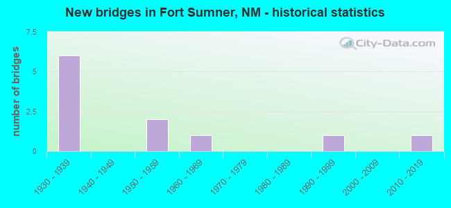
- New bridges - historical statistics
- 61930-1939
- 21950-1959
- 11960-1969
- 11990-1999
- 12010-2019

- Reconstructed bridges - Historical Statistics
- 11960-1969
- 01970-1979
- 01980-1989
- 11990-1999


- Bridge Condition - Deck
- 75.0%Good
- 25.0%Fair

- Bridge Condition - Superstructure
- 50.0%Good
- 25.0%Satisfactory
- 25.0%Fair

- Bridge Condition - Substructure
- 50.0%Good
- 25.0%Satisfactory
- 25.0%Fair

- Bridge Condition - Channel
- 12.5%Very good
- 75.0%Good
- 12.5%Fair
Find on map >> Show street view
Structure Number: 401-FS1, Location: 12 miles NW of Ft Sumner (Lat: 34.607389, Lng: -104.389800), Route carried "on" structure: ServiceFederal lands road 203, Year Built: 1936, Status: Posted for load, Structure Length: 4.69m (15.39ft), Average Daily Traffic: 50 (year 2006), Average Future Daily Traffic: 50 (year 2035), Design Load: HS 20, Features Intersected: Sumner Dam Spillway
Minimum Vertical Clearance: 30+ m (98+ ft), Kilometerpoint: 0.000, Lanes on structure: 1, Owner: Bureau of Reclamation, Approaching Roadway Width: 7.3m (24.0ft), Material/Design: Concrete continuous, Design/Construction: Tee Beam, Number Of Spans In Main Unit: 3, Length of Maximum Span: 16.2m (53.1ft), Curb or Sidewalk Widths: Left: 0.6m (2.0ft), Right: 0.0m, Curb-To-Curb Width: 4.9m (16.1ft), Out-to-Out Width: 5.5m (18.0ft)
Condition: Deck: Fair, Superstructure: Fair, Substructure: Fair, Channel: Good, Operating Rating: 13.9 metric tons, Method Used To Determine Operating Rating: Load and Resistance Factor Rating (LRFR) rating reported by rating factor(RF) method using HL-93 loadings, Inventory Rating: 10.7 metric tons, Method Used To Determine Inventory Rating: Load and Resistance Factor Rating (LRFR) rating reported by rating factor(RF) method using HL-93 loadings, Structural Evaluation: High priority of corrective action, Deck Geometry: High priority of corrective action, Waterway Adequacy: Superior to present desirable criteria, Approach Roadway Alignment: Meets minimum limits, Designated Inspection Frequency: Every 24 months, Inspection Date: October 2021, Deck Structure Type: Concrete Cast-file-Place, Wearing Surface/Protective System: Wearing Surface: Gravel
Find on map >> Show street view
Structure Number: 212, Location: 4.6 MI E US-60 @ MP-332.1 (Lat: 34.447947, Lng: -104.172142), Route carried "on" structure: County highway 11048, Year Built: 1933, Status: Open, Structure Length: 0.64m (2.10ft), Average Daily Traffic: 3,379 (year 2018), Truck Traffic: 18%, Average Future Daily Traffic: 4,462 (year 2038), Design Load: H 15, Features Intersected: UNNAMED WATERWAY, Facility Carried by Structure: 11-C048
Minimum Vertical Clearance: 30+ m (98+ ft), Kilometerpoint: 0.000, Lanes on structure: 2, Owner: County Highway Agency, Approaching Roadway Width: 6.4m (21.0ft), Material/Design: Concrete continuous, Design/Construction: Culvert, Number Of Spans In Main Unit: 4, Length of Maximum Span: 1.5m (4.9ft)
Condition: Channel: Fair, Culverts: Satisfactory, Operating Rating: 82.6 metric tons, Method Used To Determine Operating Rating: Load Factor (LF), Inventory Rating: 24.3 metric tons, Method Used To Determine Inventory Rating: Load Factor (LF), Structural Evaluation: Equal to present minimum criteria, Waterway Adequacy: High priority of corrective action, Approach Roadway Alignment: Equal to present desirable criteria, Length Of Structure Improvement: 2.29m (7.51ft), Designated Inspection Frequency: Every 24 months, Inspection Date: July 2021, Bridge Improvement Cost: $2,000, Roadway Improvement Cost: $2,000, Total Project Cost: $28,000 ( Estimate for 2020)
Find on map >> Show street view
Structure Number: 2122, Location: 0.6 MI E OF JCT US-84 (Lat: 34.468550, Lng: -104.235619), Route carried "on" structure: US 60, Year Built: 1934, Year Reconstructed: 1960, Status: Open, Structure Length: 3.29m (10.79ft), Average Daily Traffic: 5,093 (year 2020), Truck Traffic: 16%, Average Future Daily Traffic: 3,931 (year 2040), Design Load: HS 20, Features Intersected: UNNAMED WATERWAY
Minimum Vertical Clearance: 30+ m (98+ ft), Kilometerpoint: 528.137, Lanes on structure: 4, Base Highway Network: Yes, Owner: State Highway Agency, Approaching Roadway Width: 21.3m (69.9ft), Material/Design: Concrete continuous, Design/Construction: Culvert, Number Of Spans In Main Unit: 10, Length of Maximum Span: 3.0m (9.8ft)
Condition: Channel: Good, Culverts: Satisfactory, Operating Rating: 53.5 metric tons, Method Used To Determine Operating Rating: Load Factor (LF), Inventory Rating: 32.4 metric tons, Method Used To Determine Inventory Rating: Load Factor (LF), Structural Evaluation: Equal to present minimum criteria, Waterway Adequacy: Better than present minimum criteria, Approach Roadway Alignment: Equal to present desirable criteria, Length Of Structure Improvement: 3.29m (10.79ft), Designated Inspection Frequency: Every 48 months, Inspection Date: June 2018, Bridge Improvement Cost: $465,000, Roadway Improvement Cost: $46,000, Total Project Cost: $698,000 ( Estimate for 2020)
Find on map >> Show street view
Structure Number: 2575, Location: 1.7 MI E OF JCT US-84 (Lat: 34.462781, Lng: -104.217689), Route carried "on" structure: US 60, Year Built: 1933, Status: Open, Structure Length: 0.98m (3.22ft), Average Daily Traffic: 3,220 (year 2020), Truck Traffic: 16%, Average Future Daily Traffic: 2,485 (year 2040), Design Load: HS 20, Features Intersected: UNNAMED WATERWAY
Minimum Vertical Clearance: 30+ m (98+ ft), Kilometerpoint: 529.927, Lanes on structure: 2, Base Highway Network: Yes, Owner: State Highway Agency, Approaching Roadway Width: 11.6m (38.1ft), Material/Design: Concrete continuous, Design/Construction: Culvert, Number Of Spans In Main Unit: 3, Length of Maximum Span: 3.0m (9.8ft)
Condition: Channel: Good, Culverts: Satisfactory, Operating Rating: 89.1 metric tons, Method Used To Determine Operating Rating: Load Factor (LF), Inventory Rating: 32.4 metric tons, Method Used To Determine Inventory Rating: Load Factor (LF), Structural Evaluation: Equal to present minimum criteria, Waterway Adequacy: Better than present minimum criteria, Approach Roadway Alignment: Better than present minimum criteria, Designated Inspection Frequency: Every 48 months, Inspection Date: July 2018
Find on map >> Show street view
Structure Number: 2576, Location: 2.18 MI E OF JCT US-84 (Lat: 34.460400, Lng: -104.210331), Route carried "on" structure: US 60, Year Built: 1933, Status: Open, Structure Length: 0.64m (2.10ft), Average Daily Traffic: 3,220 (year 2020), Truck Traffic: 16%, Average Future Daily Traffic: 2,485 (year 2040), Design Load: HS 20, Features Intersected: UNNAMED WATERWAY
Minimum Vertical Clearance: 30+ m (98+ ft), Kilometerpoint: 530.599, Lanes on structure: 2, Base Highway Network: Yes, Owner: State Highway Agency, Approaching Roadway Width: 11.6m (38.1ft), Material/Design: Concrete continuous, Design/Construction: Culvert, Number Of Spans In Main Unit: 2, Length of Maximum Span: 3.0m (9.8ft)
Condition: Channel: Good, Culverts: Satisfactory, Operating Rating: 64.8 metric tons, Method Used To Determine Operating Rating: Load Factor (LF), Inventory Rating: 32.4 metric tons, Method Used To Determine Inventory Rating: Load Factor (LF), Structural Evaluation: Equal to present minimum criteria, Waterway Adequacy: Equal to present minimum criteria, Approach Roadway Alignment: Equal to present desirable criteria, Designated Inspection Frequency: Every 48 months, Inspection Date: July 2018
Find on map >> Show street view
Structure Number: 6112, Location: 0.61 MI E NM-20/FT SUMNER (Lat: 34.476000, Lng: -104.254800), Route carried "on" structure: US 60, Year Built: 1958, Year Reconstructed: 1999, Status: Open, Structure Length: 4.66m (15.29ft), Average Daily Traffic: 1,375 (year 2020), Truck Traffic: 20%, Average Future Daily Traffic: 1,997 (year 2040), Design Load: HS 20, Features Intersected: LAS TRUCHAS CREEK
Minimum Vertical Clearance: 30+ m (98+ ft), Kilometerpoint: 526.159, Lanes on structure: 2, Base Highway Network: Yes, Owner: State Highway Agency, Approaching Roadway Width: 12.2m (40.0ft), Skew: 2 degrees, Material/Design: Concrete continuous, Design/Construction: Slab, Number Of Spans In Main Unit: 5, Length of Maximum Span: 10.1m (33.1ft), Curb-To-Curb Width: 11.9m (39.0ft), Out-to-Out Width: 13.8m (45.3ft)
Condition: Deck: Good, Superstructure: Good, Substructure: Good, Channel: Good, Operating Rating: 65.0 metric tons, Method Used To Determine Operating Rating: Load Factor (LF), Inventory Rating: 38.9 metric tons, Method Used To Determine Inventory Rating: Load Factor (LF), Structural Evaluation: Better than present minimum criteria, Deck Geometry: Equal to present minimum criteria, Waterway Adequacy: Equal to present desirable criteria, Approach Roadway Alignment: Equal to present minimum criteria, Length Of Structure Improvement: 4.66m (15.29ft), Designated Inspection Frequency: Every 24 months, Inspection Date: December 2020, Bridge Improvement Cost: $250,000, Roadway Improvement Cost: $90,000, Total Project Cost: $440,000 ( Estimate for 2020), Deck Structure Type: Concrete Cast-file-Place, Wearing Surface/Protective System: Deck Protection: Epoxy Coated Reinforcing
Find on map >> Show street view
Structure Number: 6933, Location: 1.1 MI N OF JCT US-60 (Lat: 34.488783, Lng: -104.245650), Route carried "on" structure: US 84, Year Built: 1968, Status: Open, Structure Length: 4.42m (14.50ft), Average Daily Traffic: 2,419 (year 2020), Truck Traffic: 16%, Average Future Daily Traffic: 1,867 (year 2040), Design Load: HS 20, Features Intersected: LAS TRUCHAS CREEK
Minimum Vertical Clearance: 30+ m (98+ ft), Kilometerpoint: 1.875, Lanes on structure: 2, Base Highway Network: Yes, Owner: State Highway Agency, Approaching Roadway Width: 12.2m (40.0ft), Material/Design: Prestressed concrete, Design/Construction: Stringer/Multi-beam, Number Of Spans In Main Unit: 3, Length of Maximum Span: 14.3m (46.9ft), Curb-To-Curb Width: 12.2m (40.0ft), Out-to-Out Width: 13.1m (43.0ft)
Condition: Deck: Good, Superstructure: Satisfactory, Substructure: Satisfactory, Channel: Good, Operating Rating: 53.9 metric tons, Method Used To Determine Operating Rating: Load Factor (LF), Inventory Rating: 32.7 metric tons, Method Used To Determine Inventory Rating: Load Factor (LF), Structural Evaluation: Equal to present minimum criteria, Deck Geometry: Equal to present minimum criteria, Waterway Adequacy: Better than present minimum criteria, Approach Roadway Alignment: Equal to present desirable criteria, Length Of Structure Improvement: 4.42m (14.50ft), Designated Inspection Frequency: Every 24 months, Inspection Date: July 2021, Bridge Improvement Cost: $305,000, Roadway Improvement Cost: $30,000, Total Project Cost: $458,000 ( Estimate for 2020), Deck Structure Type: Concrete Cast-file-Place
Find on map >> Show street view
Structure Number: 9057, Location: 0.28 MI E OF NM-20 (Lat: 34.473747, Lng: -104.259558), Route carried "on" structure: US 60, Year Built: 1999, Status: Open, Structure Length: 18.07m (59.28ft), Average Daily Traffic: 1,375 (year 2020), Truck Traffic: 20%, Average Future Daily Traffic: 1,997 (year 2040), Design Load: HS 20, Features Intersected: PECOS
Minimum Vertical Clearance: 30+ m (98+ ft), Kilometerpoint: 525.563, Lanes on structure: 2, Base Highway Network: Yes, Owner: State Highway Agency, Approaching Roadway Width: 12.5m (41.0ft), Skew: 1 degrees, Material/Design: Prestressed concrete continuous, Design/Construction: Stringer/Multi-beam, Number Of Spans In Main Unit: 5, Length of Maximum Span: 36.0m (118.1ft), Curb-To-Curb Width: 11.9m (39.0ft), Out-to-Out Width: 12.9m (42.3ft)
Condition: Deck: Good, Superstructure: Good, Substructure: Good, Channel: Very good, Operating Rating: 69.9 metric tons, Method Used To Determine Operating Rating: Load Factor (LF), Inventory Rating: 31.8 metric tons, Method Used To Determine Inventory Rating: Load Factor (LF), Structural Evaluation: Better than present minimum criteria, Deck Geometry: Equal to present minimum criteria, Waterway Adequacy: Equal to present desirable criteria, Approach Roadway Alignment: Equal to present desirable criteria, Designated Inspection Frequency: Every 24 months, Inspection Date: June 2020, Deck Structure Type: Concrete Cast-file-Place, Wearing Surface/Protective System: Deck Protection: Epoxy Coated Reinforcing
Find on map >> Show street view
Structure Number: 2266, Location: 0.4 Mi N of Jct US-60 (Lat: 34.476903, Lng: -104.245436), Route carried "under" structure: US 84, Year Built: 1939, Structure Length: 0. m, Average Daily Traffic: 2,765 (year 2020), Truck Traffic: 16%, Features Intersected: US-84, Facility Carried by Structure: RAILROAD
Minimum Vertical Clearance: 4.61m (15.12ft), Kilometerpoint: 113.555, Lanes under structure: 2, Material/Design: Steel, Design/Construction: Stringer/Multi-beam, Length of Maximum Span: 13.7m (44.9ft)
Find on map >> Show street view
Structure Number: 5823, Location: 1.1 MI W OF JCT NM-20 (Lat: 34.469100, Lng: -104.278600), Route carried "under" structure: US 60, Year Built: 1957, Structure Length: 0. m, Average Daily Traffic: 352 (year 2020), Truck Traffic: 20%, Features Intersected: US-60, Facility Carried by Structure: RAILROAD
Minimum Vertical Clearance: 5.24m (17.19ft), Kilometerpoint: 523.285, Lanes under structure: 2, Material/Design: Prestressed concrete, Design/Construction: Box Beam or Girders - Single/Spread, Length of Maximum Span: 14.0m (45.9ft)
Find on map >> Show street view
Structure Number: 9787, Location: 1.1 MI W OF JCT NM-20 (Lat: 34.469139, Lng: -104.278769), Route carried "under" structure: US 60, Year Built: 2017, Structure Length: 0. m, Average Daily Traffic: 352 (year 2020), Truck Traffic: 20%, Features Intersected: US-60, Facility Carried by Structure: RAILROAD
Minimum Vertical Clearance: 5.24m (17.19ft), Kilometerpoint: 523.520, Lanes under structure: 2, Material/Design: Prestressed concrete, Design/Construction: Box Beam or Girders - Single/Spread, Length of Maximum Span: 25.9m (85.0ft)