Bridge Statistics for Fort Wright, Kentucky (KY)
Condition, Traffic, Stress, Structural Evaluation, Project Costs
- National Bridge Inventory (NBI) Statistics
- 16Number of bridges
- 515ft / 157mTotal length
- $4,845,000Total costs
- 487,497Total average daily traffic
- 55,003Total average daily truck traffic
- National Bridge Inventory (NBI) Registered Bridges for Fort Wright
- No street view available for this location
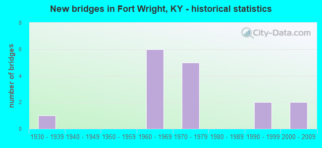
- New bridges - historical statistics
- 11930-1939
- 61960-1969
- 51970-1979
- 21990-1999
- 22000-2009

- Reconstructed bridges - Historical Statistics
- 21980-1989
- 11990-1999


- Bridge Condition - Deck
- 62.5%Good
- 37.5%Satisfactory

- Bridge Condition - Superstructure
- 25.0%Very good
- 37.5%Good
- 37.5%Satisfactory

- Bridge Condition - Substructure
- 12.5%Very good
- 25.0%Good
- 62.5%Satisfactory

- Bridge Condition - Channel
- 40.0%Good
- 40.0%Satisfactory
- 20.0%Fair
Find on map >> Show street view
Structure Number: 59B00043L, Location: SBL .75 MI NE OF US 25 OP (Lat: 39.056667, Lng: -84.543056), Route carried "on" structure: Interstate 75, Year Built: 1960, Year Reconstructed: 1992, Status: Open, Structure Length: 4.85m (15.91ft), Average Daily Traffic: 51,819 (year 2020), Truck Traffic: 16%, Average Future Daily Traffic: 55,446 (year 2040), Design Load: HS 20, Features Intersected: RIVARD DR IN FT WRIGHT
Minimum Vertical Clearance: 30+ m (98+ ft), Kilometerpoint: 303.043, Lanes on structure: 5, Lanes under structure: 1, Base Highway Network: Yes, Owner: State Highway Agency, Approaching Roadway Width: 26.2m (86.0ft), Material/Design: Concrete, Design/Construction: Tee Beam, Number Of Spans In Main Unit: 3, Length of Maximum Span: 15.2m (49.9ft), Curb or Sidewalk Widths: Left: 0.5m (1.6ft), Right: 0.5m (1.6ft), Curb-To-Curb Width: 23.8m (78.1ft), Out-to-Out Width: 24.9m (81.7ft)
Condition: Deck: Satisfactory, Superstructure: Good, Substructure: Satisfactory, Operating Rating: 90.8 metric tons, Method Used To Determine Operating Rating: Load Factor (LF), Inventory Rating: 54.4 metric tons, Method Used To Determine Inventory Rating: Load Factor (LF), Structural Evaluation: Equal to present minimum criteria, Deck Geometry: Equal to present minimum criteria, Underclear: Equal to present minimum criteria, Approach Roadway Alignment: Superior to present desirable criteria, Length Of Structure Improvement: 0.48m (1.57ft), Designated Inspection Frequency: Every 24 months, Inspection Date: November 2021, Bridge Improvement Cost: $1,626,000, Total Project Cost: $1,625,000, Deck Structure Type: Concrete Cast-file-Place, Wearing Surface/Protective System: Wearing Surface: Low Slump Concrete, Deck Protection: Epoxy Coated Reinforcing
Find on map >> Show street view
Structure Number: 59B00043R, Location: NBL .75 MI NE OF US 25 OP (Lat: 39.056389, Lng: -84.542778), Route carried "on" structure: Interstate 75, Year Built: 1960, Year Reconstructed: 1998, Status: Open, Structure Length: 4.85m (15.91ft), Average Daily Traffic: 51,819 (year 2020), Truck Traffic: 16%, Average Future Daily Traffic: 55,446 (year 2040), Design Load: HS 20, Features Intersected: RIVARD DR IN FT WRIGHT
Minimum Vertical Clearance: 30+ m (98+ ft), Kilometerpoint: 303.036, Lanes on structure: 4, Lanes under structure: 1, Base Highway Network: Yes, Owner: State Highway Agency, Approaching Roadway Width: 26.2m (86.0ft), Material/Design: Concrete, Design/Construction: Tee Beam, Number Of Spans In Main Unit: 3, Length of Maximum Span: 15.2m (49.9ft), Curb or Sidewalk Widths: Left: 0.5m (1.6ft), Right: 0.5m (1.6ft), Curb-To-Curb Width: 20.4m (66.9ft), Out-to-Out Width: 21.3m (69.9ft)
Condition: Deck: Satisfactory, Superstructure: Good, Substructure: Satisfactory, Operating Rating: 92.0 metric tons, Method Used To Determine Operating Rating: Load Factor (LF), Inventory Rating: 55.2 metric tons, Method Used To Determine Inventory Rating: Load Factor (LF), Structural Evaluation: Equal to present minimum criteria, Deck Geometry: Equal to present minimum criteria, Underclear: Equal to present minimum criteria, Approach Roadway Alignment: Superior to present desirable criteria, Designated Inspection Frequency: Every 24 months, Inspection Date: November 2021, Bridge Improvement Cost: $90,000, Total Project Cost: $90,000, Deck Structure Type: Concrete Cast-file-Place, Wearing Surface/Protective System: Wearing Surface: Low Slump Concrete, Deck Protection: Epoxy Coated Reinforcing
Find on map >> Show street view
Structure Number: 59B00047N, Location: .2 MI S OF JCT US 25-42 (Lat: 39.058889, Lng: -84.538333), Route carried "on" structure: State highway 1072, Year Built: 1960, Year Reconstructed: 1992, Status: Open, Structure Length: 7.74m (25.39ft), Average Daily Traffic: 22,545 (year 2020), Truck Traffic: 9%, Average Future Daily Traffic: 20,966 (year 2040), Design Load: HS 20, Features Intersected: I-75, Facility Carried by Structure: KYLES LANE
Minimum Vertical Clearance: 30+ m (98+ ft), Kilometerpoint: 4.286, Lanes on structure: 4, Lanes under structure: 7, Owner: State Highway Agency, Approaching Roadway Width: 30.2m (99.1ft), Skew: 11 degrees, Material/Design: Concrete continuous, Design/Construction: Tee Beam, Number Of Spans In Main Unit: 4, Length of Maximum Span: 22.9m (75.1ft), Curb or Sidewalk Widths: Left: 2.0m (6.6ft), Right: 2.0m (6.6ft), Curb-To-Curb Width: 26.2m (86.0ft), Out-to-Out Width: 30.1m (98.8ft)
Condition: Deck: Satisfactory, Superstructure: Satisfactory, Substructure: Satisfactory, Operating Rating: 43.1 metric tons, Method Used To Determine Operating Rating: Load Factor (LF), Inventory Rating: 25.9 metric tons, Method Used To Determine Inventory Rating: Load Factor (LF), Structural Evaluation: Equal to present minimum criteria, Deck Geometry: Superior to present desirable criteria, Underclear: High priority of corrective action, Approach Roadway Alignment: Better than present minimum criteria, Length Of Structure Improvement: 0.77m (2.53ft), Designated Inspection Frequency: Every 24 months, Inspection Date: November 2021, Bridge Improvement Cost: $3,131,000, Total Project Cost: $3,130,000, Deck Structure Type: Concrete Cast-file-Place, Wearing Surface/Protective System: Wearing Surface: Latex Concrete
Find on map >> Show street view
Structure Number: 59B00063L, Location: WBL OVR KY17&BANK LICK CR (Lat: 39.027778, Lng: -84.532500), Route carried "on" structure: Interstate 275, Year Built: 1977, Status: Open, Structure Length: 51.66m (169.49ft), Average Daily Traffic: 45,976 (year 2020), Truck Traffic: 8%, Average Future Daily Traffic: 49,194 (year 2040), Design Load: HS 20+Mod, Features Intersected: CSX RR-KY 17-BANKLICK CR
Minimum Vertical Clearance: 30+ m (98+ ft), Kilometerpoint: 128.699, Lanes on structure: 3, Lanes under structure: 5, Base Highway Network: Yes, Owner: State Highway Agency, Approaching Roadway Width: 16.5m (54.1ft), Skew: 11 degrees, Material/Design: Steel continuous, Design/Construction: Stringer/Multi-beam, Number Of Spans In Main Unit: 11, Length of Maximum Span: 69.5m (228.0ft), Curb or Sidewalk Widths: Left: 0.6m (2.0ft), Right: 0.6m (2.0ft), Curb-To-Curb Width: 15.5m (50.9ft), Out-to-Out Width: 16.8m (55.1ft)
Condition: Deck: Good, Superstructure: Satisfactory, Substructure: Satisfactory, Channel: Fair, Operating Rating: 61.6 metric tons, Method Used To Determine Operating Rating: Load Factor (LF), Inventory Rating: 37.0 metric tons, Method Used To Determine Inventory Rating: Load Factor (LF), Structural Evaluation: Equal to present minimum criteria, Deck Geometry: Somewhat better than minimum adequacy, Underclear: High priority of corrective action, Waterway Adequacy: Superior to present desirable criteria, Approach Roadway Alignment: Superior to present desirable criteria, Designated Inspection Frequency: Every 24 months, Inspection Date: October 2021, Deck Structure Type: Concrete Cast-file-Place, Wearing Surface/Protective System: Wearing Surface: Low Slump Concrete
Find on map >> Show street view
Structure Number: 59B00063R, Location: EBL OVR KY17&BANK LICK CR (Lat: 39.027778, Lng: -84.532500), Route carried "on" structure: Interstate 275, Year Built: 1977, Status: Open, Structure Length: 51.66m (169.49ft), Average Daily Traffic: 45,976 (year 2020), Truck Traffic: 8%, Average Future Daily Traffic: 49,194 (year 2040), Design Load: HS 20+Mod, Features Intersected: CSX RR-KY 17-BANKLICK CR
Minimum Vertical Clearance: 30+ m (98+ ft), Kilometerpoint: 128.704, Lanes on structure: 3, Lanes under structure: 5, Base Highway Network: Yes, Owner: State Highway Agency, Approaching Roadway Width: 16.5m (54.1ft), Skew: 11 degrees, Material/Design: Steel continuous, Design/Construction: Stringer/Multi-beam, Number Of Spans In Main Unit: 11, Length of Maximum Span: 69.5m (228.0ft), Curb or Sidewalk Widths: Left: 0.6m (2.0ft), Right: 0.6m (2.0ft), Curb-To-Curb Width: 15.5m (50.9ft), Out-to-Out Width: 16.8m (55.1ft)
Condition: Deck: Good, Superstructure: Satisfactory, Substructure: Satisfactory, Channel: Good, Operating Rating: 61.6 metric tons, Method Used To Determine Operating Rating: Load Factor (LF), Inventory Rating: 37.0 metric tons, Method Used To Determine Inventory Rating: Load Factor (LF), Structural Evaluation: Equal to present minimum criteria, Deck Geometry: Somewhat better than minimum adequacy, Underclear: High priority of corrective action, Waterway Adequacy: Superior to present desirable criteria, Approach Roadway Alignment: Superior to present desirable criteria, Designated Inspection Frequency: Every 24 months, Inspection Date: October 2021, Deck Structure Type: Concrete Cast-file-Place, Wearing Surface/Protective System: Wearing Surface: Low Slump Concrete
Find on map >> Show street view
Structure Number: 59B00066N, Location: AT JCT KY 371 (Lat: 39.032778, Lng: -84.533333), Route carried "on" structure: State highway 17, Year Built: 1974, Status: Open, Structure Length: 0.86m (2.82ft), Average Daily Traffic: 32,125 (year 2020), Truck Traffic: 4%, Average Future Daily Traffic: 30,197 (year 2040), Design Load: HS 20+Mod, Features Intersected: HORSE BRANCH CREEK, Facility Carried by Structure: MADISON ROAD/MADIS
Minimum Vertical Clearance: 30+ m (98+ ft), Kilometerpoint: 30.359, Lanes on structure: 5, Base Highway Network: Yes, Owner: State Highway Agency, Approaching Roadway Width: 11.0m (36.1ft), Skew: 4 degrees, Material/Design: Concrete, Design/Construction: Culvert, Number Of Spans In Main Unit: 1, Length of Maximum Span: 8.6m (28.2ft)
Condition: Channel: Satisfactory, Culverts: Satisfactory, Structural Evaluation: Equal to present minimum criteria, Waterway Adequacy: Better than present minimum criteria, Approach Roadway Alignment: Equal to present minimum criteria, Designated Inspection Frequency: Every 24 months, Inspection Date: November 2021
Find on map >> Show street view
Structure Number: 59B00109N, Location: .1 mi SE of JCT KY-17 (Lat: 39.034722, Lng: -84.530278), Route carried "on" structure: State highway 1072, Year Built: 2007, Status: Open, Structure Length: 15.26m (50.07ft), Average Daily Traffic: 3,039 (year 2018), Average Future Daily Traffic: 2,856 (year 2038), Design Load: HS 25 or greater, Features Intersected: BANKLICK CREEK
Minimum Vertical Clearance: 30+ m (98+ ft), Kilometerpoint: 1.014, Lanes on structure: 4, Owner: State Highway Agency, Approaching Roadway Width: 19.5m (64.0ft), Material/Design: Prestressed concrete continuous, Design/Construction: Stringer/Multi-beam, Number Of Spans In Main Unit: 4, Length of Maximum Span: 41.5m (136.2ft), Curb or Sidewalk Widths: Left: 2.0m (6.6ft), Right: 2.0m (6.6ft), Curb-To-Curb Width: 19.5m (64.0ft), Out-to-Out Width: 23.5m (77.1ft)
Condition: Deck: Good, Superstructure: Good, Substructure: Very good, Channel: Satisfactory, Operating Rating: 70.7 metric tons, Method Used To Determine Operating Rating: Load Factor (LF), Inventory Rating: 42.4 metric tons, Method Used To Determine Inventory Rating: Load Factor (LF), Structural Evaluation: Better than present minimum criteria, Deck Geometry: Better than present minimum criteria, Waterway Adequacy: Equal to present desirable criteria, Approach Roadway Alignment: Equal to present desirable criteria, Designated Inspection Frequency: Every 24 months, Inspection Date: October 2021, Deck Structure Type: Concrete Cast-file-Place, Wearing Surface/Protective System: Wearing Surface: Monolithic Concrete, Deck Protection: Epoxy Coated Reinforcing
Find on map >> Show street view
Structure Number: 59B00110N, Location: 0.3 mi SE of JCT KY-17 (Lat: 39.032778, Lng: -84.526944), Route carried "on" structure: State highway 1072, Year Built: 2007, Status: Open, Structure Length: 10.62m (34.84ft), Average Daily Traffic: 3,039 (year 2018), Average Future Daily Traffic: 2,856 (year 2038), Design Load: HS 25 or greater, Features Intersected: CSX RAILROAD
Minimum Vertical Clearance: 30+ m (98+ ft), Kilometerpoint: 0.650, Lanes on structure: 2, Owner: State Highway Agency, Approaching Roadway Width: 8.6m (28.2ft), Material/Design: Prestressed concrete continuous, Design/Construction: Stringer/Multi-beam, Number Of Spans In Main Unit: 4, Length of Maximum Span: 30.2m (99.1ft), Curb or Sidewalk Widths: Left: 1.9m (6.2ft), Right: 1.9m (6.2ft), Curb-To-Curb Width: 8.6m (28.2ft), Out-to-Out Width: 12.4m (40.7ft)
Condition: Deck: Good, Superstructure: Very good, Substructure: Good, Operating Rating: 79.4 metric tons, Method Used To Determine Operating Rating: Load Factor (LF), Inventory Rating: 47.6 metric tons, Method Used To Determine Inventory Rating: Load Factor (LF), Structural Evaluation: Better than present minimum criteria, Deck Geometry: Meets minimum limits, Underclear: Superior to present desirable criteria, Approach Roadway Alignment: Equal to present desirable criteria, Designated Inspection Frequency: Every 24 months, Inspection Date: October 2021, Deck Structure Type: Concrete Cast-file-Place, Wearing Surface/Protective System: Wearing Surface: Monolithic Concrete, Deck Protection: Epoxy Coated Reinforcing
Find on map >> Show street view
Structure Number: 59C00062N, Location: 1000' S. JCT I-275 &KY17 (Lat: 39.025556, Lng: -84.534444), Route carried "on" structure: Other road 1405, Year Built: 1999, Status: Posted for load, Structure Length: 9.39m (30.81ft), Average Daily Traffic: 1,115 (year 2006), Average Future Daily Traffic: 1,519 (year 2026), Design Load: HS 25 or greater, Features Intersected: BANKLICK CREEK, Facility Carried by Structure: MADISON ROAD/MADIS
Minimum Vertical Clearance: 30+ m (98+ ft), Kilometerpoint: 0.074, Lanes on structure: 2, Owner: City or Municipal Highway Agency, Approaching Roadway Width: 7.3m (24.0ft), Skew: 10 degrees, Material/Design: Prestressed concrete continuous, Design/Construction: Stringer/Multi-beam, Number Of Spans In Main Unit: 4, Length of Maximum Span: 24.4m (80.1ft), Curb-To-Curb Width: 7.9m (25.9ft), Out-to-Out Width: 8.9m (29.2ft)
Condition: Deck: Good, Superstructure: Very good, Substructure: Good, Channel: Good, Operating Rating: 16.4 metric tons, Method Used To Determine Operating Rating: Field evaluation and documented engineering judgment, Inventory Rating: 16.4 metric tons, Method Used To Determine Inventory Rating: Field evaluation and documented engineering judgment, Structural Evaluation: Meets minimum limits, Deck Geometry: Meets minimum limits, Waterway Adequacy: Equal to present desirable criteria, Approach Roadway Alignment: Equal to present minimum criteria, Bridge Posting: Required (Relationship of Operating Rating to Maximum Legal Load: > 39.9% below), Designated Inspection Frequency: Every 24 months, Inspection Date: June 2020, Deck Structure Type: Concrete Cast-file-Place, Wearing Surface/Protective System: Wearing Surface: Monolithic Concrete, Deck Protection: Epoxy Coated Reinforcing
Find on map >> Show street view
Structure Number: 59B00043L, Location: SBL .75 MI NE OF US 25 OP (Lat: 39.056667, Lng: -84.543056), Route carried "under" structure: City street 9044, Year Built: 1960, Structure Length: 0. m, Average Daily Traffic: 335 (year 2006), Features Intersected: RIVARD DR IN FT WRIGHT, Facility Carried by Structure: I-75 NC
Minimum Vertical Clearance: 30+ m (98+ ft), Kilometerpoint: 0.122, Lanes on structure: 5, Lanes under structure: 1, Material/Design: Concrete, Design/Construction: Tee Beam, Length of Maximum Span: 15.2m (49.9ft)
Find on map >> Show street view
Structure Number: 59B00043R, Location: NBL .75 MI NE OF US 25 OP (Lat: 39.056389, Lng: -84.542778), Route carried "under" structure: City street 9044, Year Built: 1960, Structure Length: 0. m, Average Daily Traffic: 446 (year 2006), Features Intersected: RIVARD DR IN FT WRIGHT, Facility Carried by Structure: I-75
Minimum Vertical Clearance: 30+ m (98+ ft), Kilometerpoint: 0.142, Lanes on structure: 4, Lanes under structure: 1, Material/Design: Concrete, Design/Construction: Tee Beam, Length of Maximum Span: 15.2m (49.9ft)
Find on map >> Show street view
Structure Number: 59B00047N, Location: .2 MI S OF JCT US 25-42 (Lat: 39.058889, Lng: -84.538333), Route carried "under" structure: Interstate 75, Year Built: 1960, Structure Length: 0. m, Average Daily Traffic: 153,657 (year 2019), Truck Traffic: 16%, Features Intersected: I-75, Facility Carried by Structure: KYLES LANE
Minimum Vertical Clearance: 5.82m (19.09ft), Kilometerpoint: 303.525, Lanes on structure: 4, Lanes under structure: 7, Material/Design: Concrete continuous, Design/Construction: Tee Beam, Length of Maximum Span: 22.9m (75.1ft)
Find on map >> Show street view
Structure Number: 59B00063L, Location: WBL OVR KY17&BANK LICK CR (Lat: 39.027778, Lng: -84.532500), Route carried "under" structure: State highway 17, Year Built: 1977, Structure Length: 0. m, Average Daily Traffic: 32,125 (year 2020), Truck Traffic: 4%, Features Intersected: CSX RR-KY 17-BANKLICK CR, Facility Carried by Structure: I-275 WB
Minimum Vertical Clearance: 30+ m (98+ ft), Kilometerpoint: 29.873, Lanes on structure: 3, Lanes under structure: 5, Material/Design: Steel continuous, Design/Construction: Stringer/Multi-beam, Length of Maximum Span: 69.5m (228.0ft)
Find on map >> Show street view
Structure Number: 59B00063R, Location: EBL OVR KY17&BANK LICK CR (Lat: 39.027778, Lng: -84.532500), Route carried "under" structure: State highway 17, Year Built: 1977, Structure Length: 0. m, Average Daily Traffic: 32,125 (year 2020), Truck Traffic: 4%, Features Intersected: CSX RR-KY 17-BANKLICK CR, Facility Carried by Structure: I-275 EB
Minimum Vertical Clearance: 30+ m (98+ ft), Kilometerpoint: 29.903, Lanes on structure: 3, Lanes under structure: 5, Material/Design: Steel continuous, Design/Construction: Stringer/Multi-beam, Length of Maximum Span: 69.5m (228.0ft)
Find on map >> Show street view
Structure Number: 59B00092N, Location: 1500' EAST JCT KY 17 (Lat: 39.041667, Lng: -84.515000), Route carried "under" structure: State highway 3070, Year Built: 1993, Structure Length: 0. m, Average Daily Traffic: 8,521 (year 2019), Truck Traffic: 7%, Features Intersected: HOWARD LITZLER RD., Facility Carried by Structure: CSX RAILROAD
Minimum Vertical Clearance: 4.75m (15.58ft), Kilometerpoint: 0.698, Lanes under structure: 2, Material/Design: Steel, Design/Construction: Stringer/Multi-beam, Length of Maximum Span: 20.4m (66.9ft)
Find on map >> Show street view
Structure Number: 59R00628N, Location: 800 FT E CR 5316 (Lat: 39.064167, Lng: -84.558611), Route carried "under" structure: County highway 1317, Year Built: 1930, Structure Length: 0. m, Average Daily Traffic: 2,835 (year 2018), Features Intersected: NS (SOUTHERN) RAILROAD, Facility Carried by Structure: AMSTERDAM EAST RD
Kilometerpoint: 0.002, Lanes under structure: 2, Material/Design: Steel, Design/Construction: Stringer/Multi-beam, Length of Maximum Span: 17.7m (58.1ft)