Bridge Statistics for Fouke, Arkansas (AR)
Condition, Traffic, Stress, Structural Evaluation, Project Costs
- National Bridge Inventory (NBI) Statistics
- 34Number of bridges
- 279ft / 84.7mTotal length
- 160,342Total average daily traffic
- 27,827Total average daily truck traffic
- National Bridge Inventory (NBI) Registered Bridges for Fouke
- No street view available for this location
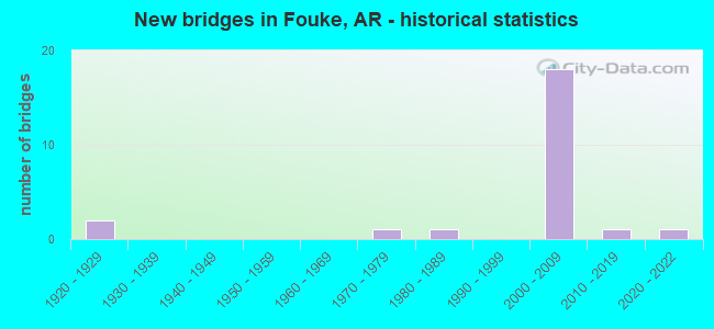
- New bridges - historical statistics
- 21920-1929
- 11970-1979
- 11980-1989
- 182000-2009
- 12010-2019
- 12020-2022

- Reconstructed bridges - Historical Statistics
- 11950-1959
- 11960-1969


- Bridge Condition - Deck
- 30.8%Very good
- 61.5%Good
- 7.7%Satisfactory

- Bridge Condition - Superstructure
- 84.6%Very good
- 15.4%Satisfactory

- Bridge Condition - Substructure
- 92.3%Very good
- 7.7%Good

- Bridge Condition - Channel
- 25.0%Very good
- 56.3%Good
- 18.8%Satisfactory

- Bridge Condition - Culverts
- 27.3%Very good
- 72.7%Good
Find on map >> Show street view
Structure Number: 5209, Location: .20 MI N JCT WITH SH 134 (Lat: 33.231239, Lng: -93.887075), Route carried "on" structure: US 71, Year Built: 1970, Status: Open, Structure Length: 3.02m (9.91ft), Average Daily Traffic: 1,396 (year 2018), Truck Traffic: 1%, Average Future Daily Traffic: 2,386 (year 2028), Design Load: HS 20, Features Intersected: BOGGY CREEK
Minimum Vertical Clearance: 30+ m (98+ ft), Kilometerpoint: 24.462, Lanes on structure: 2, Owner: State Highway Agency, Approaching Roadway Width: 13.4m (44.0ft), Material/Design: Concrete, Design/Construction: Slab, Number Of Spans In Main Unit: 3, Length of Maximum Span: 10.1m (33.1ft), Curb or Sidewalk Widths: Left: 0.2m (0.7ft), Right: 0.2m (0.7ft), Curb-To-Curb Width: 13.1m (43.0ft), Out-to-Out Width: 14.0m (45.9ft)
Condition: Deck: Satisfactory, Superstructure: Satisfactory, Substructure: Good, Channel: Good, Operating Rating: 47.2 metric tons, Method Used To Determine Operating Rating: Load Factor (LF), Inventory Rating: 28.1 metric tons, Method Used To Determine Inventory Rating: Load Factor (LF), Structural Evaluation: Equal to present minimum criteria, Deck Geometry: Better than present minimum criteria, Waterway Adequacy: Better than present minimum criteria, Approach Roadway Alignment: Equal to present desirable criteria, Designated Inspection Frequency: Every 24 months, Critical Feature Inspection Frequency: Every 24 months, Inspection Date: March 2020, Deck Structure Type: Concrete Cast-file-Place, Wearing Surface/Protective System: Wearing Surface: Monolithic Concrete
Find on map >> Show street view
Structure Number: 6784, Location: 0.5 MI. N. OF FOUKE (Lat: 33.269422, Lng: -93.897706), Route carried "on" structure: County highway 20846, Year Built: 2003, Status: Open, Structure Length: 10.85m (35.60ft), Average Daily Traffic: 1,900 (year 2018), Truck Traffic: 1%, Average Future Daily Traffic: 126 (year 2023), Design Load: HS 20, Features Intersected: I 49 N.B & S.B-18.34, Facility Carried by Structure: N. FOUKE RD.-0.40
Minimum Vertical Clearance: 30+ m (98+ ft), Kilometerpoint: 0.644, Lanes on structure: 2, Lanes under structure: 4, Owner: State Highway Agency, Approaching Roadway Width: 11.0m (36.1ft), Material/Design: Steel continuous, Design/Construction: Stringer/Multi-beam, Number Of Spans In Main Unit: 4, Length of Maximum Span: 32.0m (105.0ft), Curb-To-Curb Width: 10.8m (35.4ft), Out-to-Out Width: 11.7m (38.4ft)
Condition: Deck: Very good, Superstructure: Very good, Substructure: Very good, Operating Rating: 54.4 metric tons, Method Used To Determine Operating Rating: Load Factor (LF), Inventory Rating: 32.7 metric tons, Method Used To Determine Inventory Rating: Load Factor (LF), Structural Evaluation: Equal to present desirable criteria, Deck Geometry: Equal to present minimum criteria, Underclear: Superior to present desirable criteria, Approach Roadway Alignment: Better than present minimum criteria, Designated Inspection Frequency: Every 24 months, Critical Feature Inspection Frequency: Every 24 months, Inspection Date: April 2020, Deck Structure Type: Concrete Cast-file-Place, Wearing Surface/Protective System: Wearing Surface: Monolithic Concrete, Deck Protection: Epoxy Coated Reinforcing
Find on map >> Show street view
Structure Number: 6785, Location: 2.5 MI. NORTH OF FOUKE (Lat: 33.291114, Lng: -93.919117), Route carried "on" structure: County highway 26, Year Built: 2003, Status: Open, Structure Length: 13.59m (44.59ft), Average Daily Traffic: 1,453 (year 1987), Truck Traffic: 1%, Average Future Daily Traffic: 327 (year 2007), Design Load: HS 20, Features Intersected: I 49 N.&S.BND.20.31
Minimum Vertical Clearance: 30+ m (98+ ft), Kilometerpoint: 1.046, Lanes on structure: 2, Lanes under structure: 4, Owner: State Highway Agency, Approaching Roadway Width: 8.5m (27.9ft), Skew: 4 degrees, Material/Design: Steel continuous, Design/Construction: Stringer/Multi-beam, Number Of Spans In Main Unit: 4, Length of Maximum Span: 39.9m (130.9ft), Curb-To-Curb Width: 8.4m (27.6ft), Out-to-Out Width: 9.4m (30.8ft)
Condition: Deck: Very good, Superstructure: Very good, Substructure: Very good, Operating Rating: 49.0 metric tons, Method Used To Determine Operating Rating: Load Factor (LF), Inventory Rating: 29.0 metric tons, Method Used To Determine Inventory Rating: Load Factor (LF), Structural Evaluation: Better than present minimum criteria, Deck Geometry: Meets minimum limits, Underclear: Better than present minimum criteria, Approach Roadway Alignment: Better than present minimum criteria, Designated Inspection Frequency: Every 24 months, Critical Feature Inspection Frequency: Every 24 months, Inspection Date: April 2020, Deck Structure Type: Concrete Cast-file-Place, Wearing Surface/Protective System: Wearing Surface: Monolithic Concrete, Deck Protection: Epoxy Coated Reinforcing
Find on map >> Show street view
Structure Number: 20807, Location: 3 MI N OF FOUKE (Lat: 33.311381, Lng: -93.865269), Route carried "on" structure: County highway 10, Year Built: 1989, Status: Open, Structure Length: 0.85m (2.79ft), Average Daily Traffic: 2,631 (year 2018), Truck Traffic: 1%, Average Future Daily Traffic: 201 (year 2009), Features Intersected: BRANCH OF BEECH CREEK
Minimum Vertical Clearance: 30+ m (98+ ft), Kilometerpoint: 15.595, Lanes on structure: 2, Owner: County Highway Agency, Approaching Roadway Width: 8.5m (27.9ft), Material/Design: Concrete, Design/Construction: Culvert, Number Of Spans In Main Unit: 3, Length of Maximum Span: 2.7m (8.9ft)
Condition: Channel: Satisfactory, Culverts: Very good, Operating Rating: 35.4 metric tons, Method Used To Determine Operating Rating: Load Factor (LF), Inventory Rating: 20.9 metric tons, Method Used To Determine Inventory Rating: Load Factor (LF), Structural Evaluation: Somewhat better than minimum adequacy, Waterway Adequacy: Equal to present desirable criteria, Approach Roadway Alignment: Equal to present desirable criteria, Designated Inspection Frequency: Every 24 months, Critical Feature Inspection Frequency: Every 24 months, Inspection Date: August 2021
Find on map >> Show street view
Structure Number: 22915, Location: 2.5 MI. N.W OF FOUKE (Lat: 33.291078, Lng: -93.923819), Route carried "on" structure: County highway 26, Year Built: 2005, Status: Open, Structure Length: 1.55m (5.09ft), Average Daily Traffic: 1,453 (year 2018), Truck Traffic: 1%, Average Future Daily Traffic: 471 (year 2024), Design Load: H 20, Features Intersected: MILL CREEK
Minimum Vertical Clearance: 30+ m (98+ ft), Kilometerpoint: 1.497, Lanes on structure: 2, Owner: County Highway Agency, Approaching Roadway Width: 9.4m (30.8ft), Material/Design: Concrete, Design/Construction: Culvert, Number Of Spans In Main Unit: 4, Length of Maximum Span: 3.7m (12.1ft)
Condition: Channel: Good, Culverts: Very good, Operating Rating: 32.7 metric tons, Method Used To Determine Operating Rating: Load Factor (LF), Inventory Rating: 20.0 metric tons, Method Used To Determine Inventory Rating: Load Factor (LF), Structural Evaluation: Somewhat better than minimum adequacy, Waterway Adequacy: Equal to present minimum criteria, Approach Roadway Alignment: Equal to present minimum criteria, Designated Inspection Frequency: Every 24 months, Critical Feature Inspection Frequency: Every 24 months, Inspection Date: December 2020
Find on map >> Show street view
Structure Number: 24092, Location: 1 M S JCT CO RD 43 (Lat: 33.269689, Lng: -93.912289), Route carried "on" structure: County highway 41, Year Built: 2019, Status: Posted for load-capacity, Structure Length: 1.52m (4.99ft), Average Daily Traffic: 187 (year 2018), Truck Traffic: 1%, Features Intersected: CHICKEN CREEK
Minimum Vertical Clearance: 30+ m (98+ ft), Kilometerpoint: 2.977, Lanes on structure: 2, Owner: County Highway Agency, Approaching Roadway Width: 5.8m (19.0ft), Material/Design: Steel, Design/Construction: Stringer/Multi-beam, Number Of Spans In Main Unit: 1, Length of Maximum Span: 14.6m (47.9ft), Curb-To-Curb Width: 7.2m (23.6ft), Out-to-Out Width: 7.3m (24.0ft)
Condition: Deck: Good, Superstructure: Very good, Substructure: Very good, Channel: Very good, Operating Rating: 54.4 metric tons, Method Used To Determine Operating Rating: Load Factor (LF), Inventory Rating: 32.7 metric tons, Method Used To Determine Inventory Rating: Load Factor (LF), Structural Evaluation: Equal to present desirable criteria, Deck Geometry: Meets minimum limits, Waterway Adequacy: Somewhat better than minimum adequacy, Approach Roadway Alignment: Equal to present minimum criteria, Designated Inspection Frequency: Every 24 months, Critical Feature Inspection Frequency: Every 24 months, Inspection Date: December 2021, Deck Structure Type: Concrete Cast-file-Place, Wearing Surface/Protective System: Wearing Surface: Monolithic Concrete
Find on map >> Show street view
Structure Number: 24122, Location: 1.5 M W JCT US 71 (Lat: 33.283528, Lng: -93.922200), Route carried "on" structure: County highway 43, Year Built: 2020, Status: Open, Structure Length: 1.53m (5.02ft), Average Daily Traffic: 176 (year 2018), Truck Traffic: 1%, Average Future Daily Traffic: 398 (year 2002), Features Intersected: Mill Creek
Minimum Vertical Clearance: 30+ m (98+ ft), Kilometerpoint: 7.258, Lanes on structure: 2, Owner: County Highway Agency, Approaching Roadway Width: 6.1m (20.0ft), Material/Design: Concrete, Design/Construction: Stringer/Multi-beam, Number Of Spans In Main Unit: 1, Length of Maximum Span: 14.1m (46.3ft), Curb-To-Curb Width: 7.1m (23.3ft), Out-to-Out Width: 7.3m (24.0ft)
Condition: Deck: Very good, Superstructure: Very good, Substructure: Very good, Channel: Good, Operating Rating: 54.4 metric tons, Method Used To Determine Operating Rating: Load Factor (LF), Inventory Rating: 32.7 metric tons, Method Used To Determine Inventory Rating: Load Factor (LF), Structural Evaluation: Equal to present desirable criteria, Deck Geometry: Meets minimum limits, Waterway Adequacy: Somewhat better than minimum adequacy, Approach Roadway Alignment: Somewhat better than minimum adequacy, Designated Inspection Frequency: Every 24 months, Critical Feature Inspection Frequency: Every 24 months, Inspection Date: April 2020, Deck Structure Type: Concrete Cast-file-Place
Find on map >> Show street view
Structure Number: A6736, Location: 2.5 MI. SO. OF FOUKE (Lat: 33.224617, Lng: -93.873603), Route carried "on" structure: Interstate 49, Year Built: 2004, Status: Open, Structure Length: 3.96m (12.99ft), Average Daily Traffic: 3,000 (year 2018), Truck Traffic: 1%, Average Future Daily Traffic: 2,575 (year 2028), Design Load: HS 20, Features Intersected: S.H. 134- 01 - 0.80
Minimum Vertical Clearance: 30+ m (98+ ft), Kilometerpoint: 23.545, Lanes on structure: 2, Lanes under structure: 2, Base Highway Network: Yes (Inventory Route: 490, Subroute: 49), Owner: State Highway Agency, Approaching Roadway Width: 12.2m (40.0ft), Material/Design: Steel continuous, Design/Construction: Stringer/Multi-beam, Number Of Spans In Main Unit: 3, Length of Maximum Span: 16.2m (53.1ft), Curb-To-Curb Width: 12.0m (39.4ft), Out-to-Out Width: 13.0m (42.7ft)
Condition: Deck: Good, Superstructure: Very good, Substructure: Very good, Operating Rating: 54.4 metric tons, Method Used To Determine Operating Rating: Load Factor (LF), Inventory Rating: 32.7 metric tons, Method Used To Determine Inventory Rating: Load Factor (LF), Structural Evaluation: Equal to present desirable criteria, Deck Geometry: Equal to present minimum criteria, Underclear: Better than present minimum criteria, Approach Roadway Alignment: Equal to present desirable criteria, Designated Inspection Frequency: Every 24 months, Critical Feature Inspection Frequency: Every 24 months, Inspection Date: April 2020, Deck Structure Type: Concrete Cast-file-Place, Wearing Surface/Protective System: Wearing Surface: Monolithic Concrete, Deck Protection: Epoxy Coated Reinforcing
Find on map >> Show street view
Structure Number: A6737, Location: 1.5 MI. SO. OF FOUKE (Lat: 33.240147, Lng: -93.873608), Route carried "on" structure: Interstate 49, Year Built: 2004, Status: Open, Structure Length: 5.61m (18.41ft), Average Daily Traffic: 18,000 (year 2018), Truck Traffic: 1%, Average Future Daily Traffic: 2,575 (year 2028), Design Load: HS 20, Features Intersected: BOGGY CREEK
Minimum Vertical Clearance: 30+ m (98+ ft), Kilometerpoint: 25.299, Lanes on structure: 2, Base Highway Network: Yes (Inventory Route: 490, Subroute: 49), Owner: State Highway Agency, Approaching Roadway Width: 12.2m (40.0ft), Skew: 3 degrees, Material/Design: Steel continuous, Design/Construction: Stringer/Multi-beam, Number Of Spans In Main Unit: 3, Length of Maximum Span: 20.1m (65.9ft), Curb-To-Curb Width: 12.4m (40.7ft), Out-to-Out Width: 13.4m (44.0ft)
Condition: Deck: Good, Superstructure: Very good, Substructure: Very good, Channel: Very good, Operating Rating: 54.4 metric tons, Method Used To Determine Operating Rating: Load Factor (LF), Inventory Rating: 32.7 metric tons, Method Used To Determine Inventory Rating: Load Factor (LF), Structural Evaluation: Equal to present desirable criteria, Deck Geometry: Better than present minimum criteria, Waterway Adequacy: Equal to present desirable criteria, Approach Roadway Alignment: Equal to present desirable criteria, Designated Inspection Frequency: Every 24 months, Critical Feature Inspection Frequency: Every 24 months, Inspection Date: March 2020, Deck Structure Type: Concrete Cast-file-Place, Wearing Surface/Protective System: Wearing Surface: Monolithic Concrete, Deck Protection: Epoxy Coated Reinforcing
Find on map >> Show street view
Structure Number: A6783, Location: 0.5 MI. WEST OF FOUKE (Lat: 33.258150, Lng: -93.895939), Route carried "on" structure: Interstate 49, Year Built: 2003, Status: Open, Structure Length: 4.18m (13.71ft), Average Daily Traffic: 3,200 (year 2018), Truck Traffic: 1%, Average Future Daily Traffic: 3,140 (year 2028), Design Load: HS 20, Features Intersected: CO. RD. 7 - E- 0.10
Minimum Vertical Clearance: 30+ m (98+ ft), Kilometerpoint: 28.260, Lanes on structure: 2, Lanes under structure: 2, Owner: State Highway Agency, Approaching Roadway Width: 12.2m (40.0ft), Material/Design: Steel continuous, Design/Construction: Stringer/Multi-beam, Number Of Spans In Main Unit: 3, Length of Maximum Span: 17.1m (56.1ft), Curb-To-Curb Width: 12.0m (39.4ft), Out-to-Out Width: 13.0m (42.7ft)
Condition: Deck: Very good, Superstructure: Very good, Substructure: Very good, Operating Rating: 54.4 metric tons, Method Used To Determine Operating Rating: Load Factor (LF), Inventory Rating: 32.7 metric tons, Method Used To Determine Inventory Rating: Load Factor (LF), Structural Evaluation: Equal to present desirable criteria, Deck Geometry: Equal to present minimum criteria, Underclear: Superior to present desirable criteria, Approach Roadway Alignment: Equal to present desirable criteria, Designated Inspection Frequency: Every 24 months, Critical Feature Inspection Frequency: Every 24 months, Inspection Date: December 2020, Deck Structure Type: Concrete Cast-file-Place, Wearing Surface/Protective System: Wearing Surface: Monolithic Concrete, Deck Protection: Epoxy Coated Reinforcing
Find on map >> Show street view
Structure Number: A6832, Location: 0.5 MI. SO. OF FOUKE (Lat: 33.249400, Lng: -93.886131), Route carried "on" structure: Interstate 49, Year Built: 2004, Status: Open, Structure Length: 7.68m (25.20ft), Average Daily Traffic: 13,494 (year 2018), Truck Traffic: 1%, Average Future Daily Traffic: 2,575 (year 2028), Design Load: HS 20+Mod, Features Intersected: U.S.71- 01- 16.45
Minimum Vertical Clearance: 30+ m (98+ ft), Kilometerpoint: 26.924, Lanes on structure: 2, Lanes under structure: 2, Base Highway Network: Yes, Owner: State Highway Agency, Approaching Roadway Width: 12.2m (40.0ft), Skew: 2 degrees, Material/Design: Steel continuous, Design/Construction: Stringer/Multi-beam, Number Of Spans In Main Unit: 3, Length of Maximum Span: 34.1m (111.9ft), Curb-To-Curb Width: 12.0m (39.4ft), Out-to-Out Width: 13.0m (42.7ft)
Condition: Deck: Good, Superstructure: Very good, Substructure: Very good, Operating Rating: 54.4 metric tons, Method Used To Determine Operating Rating: Load Factor (LF), Inventory Rating: 32.7 metric tons, Method Used To Determine Inventory Rating: Load Factor (LF), Structural Evaluation: Equal to present desirable criteria, Deck Geometry: Equal to present minimum criteria, Underclear: Superior to present desirable criteria, Approach Roadway Alignment: Equal to present desirable criteria, Designated Inspection Frequency: Every 24 months, Critical Feature Inspection Frequency: Every 24 months, Inspection Date: April 2020, Deck Structure Type: Concrete Cast-file-Place, Wearing Surface/Protective System: Wearing Surface: Monolithic Concrete, Deck Protection: Epoxy Coated Reinforcing
Find on map >> Show street view
Structure Number: B6736, Location: 2.5 MI. SO. OF FOUKE (Lat: 33.224608, Lng: -93.873261), Route carried "on" structure: Interstate 49, Year Built: 2004, Status: Open, Structure Length: 3.96m (12.99ft), Average Daily Traffic: 3,000 (year 2018), Truck Traffic: 34%, Average Future Daily Traffic: 7,800 (year 2038), Design Load: HS 20, Features Intersected: S.H. 134
Minimum Vertical Clearance: 30+ m (98+ ft), Kilometerpoint: 23.545, Lanes on structure: 2, Lanes under structure: 2, Base Highway Network: Yes (Inventory Route: 490, Subroute: 49), Owner: State Highway Agency, Approaching Roadway Width: 12.2m (40.0ft), Material/Design: Steel continuous, Design/Construction: Stringer/Multi-beam, Number Of Spans In Main Unit: 3, Length of Maximum Span: 16.2m (53.1ft), Curb-To-Curb Width: 12.0m (39.4ft), Out-to-Out Width: 13.0m (42.7ft)
Condition: Deck: Good, Superstructure: Satisfactory, Substructure: Very good, Operating Rating: 54.4 metric tons, Method Used To Determine Operating Rating: Load Factor (LF), Inventory Rating: 32.7 metric tons, Method Used To Determine Inventory Rating: Load Factor (LF), Structural Evaluation: Equal to present minimum criteria, Deck Geometry: Equal to present minimum criteria, Underclear: Better than present minimum criteria, Approach Roadway Alignment: Equal to present desirable criteria, Designated Inspection Frequency: Every 24 months, Critical Feature Inspection Frequency: Every 24 months, Inspection Date: April 2020, Deck Structure Type: Concrete Cast-file-Place, Wearing Surface/Protective System: Wearing Surface: Monolithic Concrete, Deck Protection: Epoxy Coated Reinforcing
Find on map >> Show street view
Structure Number: B6737, Location: 1.5 MI. SO. OF FOUKE (Lat: 33.240389, Lng: -93.873328), Route carried "on" structure: Interstate 49, Year Built: 2004, Status: Open, Structure Length: 5.61m (18.41ft), Average Daily Traffic: 18,000 (year 2018), Truck Traffic: 34%, Average Future Daily Traffic: 2,575 (year 2028), Design Load: HS 20, Features Intersected: BOGGY CREEK
Minimum Vertical Clearance: 30+ m (98+ ft), Kilometerpoint: 25.299, Lanes on structure: 2, Base Highway Network: Yes (Inventory Route: 490, Subroute: 49), Owner: State Highway Agency, Approaching Roadway Width: 12.2m (40.0ft), Skew: 3 degrees, Material/Design: Steel continuous, Design/Construction: Stringer/Multi-beam, Number Of Spans In Main Unit: 3, Length of Maximum Span: 20.1m (65.9ft), Curb-To-Curb Width: 12.4m (40.7ft), Out-to-Out Width: 13.4m (44.0ft)
Condition: Deck: Good, Superstructure: Very good, Substructure: Very good, Channel: Very good, Operating Rating: 54.4 metric tons, Method Used To Determine Operating Rating: Load Factor (LF), Inventory Rating: 32.7 metric tons, Method Used To Determine Inventory Rating: Load Factor (LF), Structural Evaluation: Equal to present desirable criteria, Deck Geometry: Better than present minimum criteria, Waterway Adequacy: Equal to present desirable criteria, Approach Roadway Alignment: Equal to present desirable criteria, Designated Inspection Frequency: Every 24 months, Critical Feature Inspection Frequency: Every 24 months, Inspection Date: March 2020, Deck Structure Type: Concrete Cast-file-Place, Wearing Surface/Protective System: Wearing Surface: Monolithic Concrete, Deck Protection: Epoxy Coated Reinforcing
Find on map >> Show street view
Structure Number: B6783, Location: 0.5 MI W OF FOUKE (Lat: 33.258281, Lng: -93.895639), Route carried "on" structure: Interstate 49, Year Built: 2003, Status: Open, Structure Length: 4.18m (13.71ft), Average Daily Traffic: 3,200 (year 2018), Truck Traffic: 1%, Average Future Daily Traffic: 3,140 (year 2028), Design Load: HS 20, Features Intersected: CO. RD. 7 ZONE -E
Minimum Vertical Clearance: 30+ m (98+ ft), Kilometerpoint: 28.260, Lanes on structure: 2, Lanes under structure: 2, Owner: State Highway Agency, Approaching Roadway Width: 12.2m (40.0ft), Material/Design: Steel continuous, Design/Construction: Stringer/Multi-beam, Number Of Spans In Main Unit: 3, Length of Maximum Span: 17.1m (56.1ft), Curb-To-Curb Width: 12.0m (39.4ft), Out-to-Out Width: 13.0m (42.7ft)
Condition: Deck: Good, Superstructure: Very good, Substructure: Very good, Operating Rating: 54.4 metric tons, Method Used To Determine Operating Rating: Load Factor (LF), Inventory Rating: 32.7 metric tons, Method Used To Determine Inventory Rating: Load Factor (LF), Structural Evaluation: Equal to present desirable criteria, Deck Geometry: Equal to present minimum criteria, Underclear: Better than present minimum criteria, Approach Roadway Alignment: Equal to present desirable criteria, Designated Inspection Frequency: Every 24 months, Critical Feature Inspection Frequency: Every 24 months, Inspection Date: December 2020, Deck Structure Type: Concrete Cast-file-Place, Wearing Surface/Protective System: Wearing Surface: Monolithic Concrete, Deck Protection: Epoxy Coated Reinforcing
Find on map >> Show street view
Structure Number: B6832, Location: 0.5 MI. SO. OF FOUKE. (Lat: 33.249731, Lng: -93.886111), Route carried "on" structure: Interstate 49, Year Built: 2004, Status: Open, Structure Length: 7.68m (25.20ft), Average Daily Traffic: 13,494 (year 2018), Truck Traffic: 34%, Average Future Daily Traffic: 2,575 (year 2028), Design Load: HS 20+Mod, Features Intersected: U.S 71-SEC.01-16.47
Minimum Vertical Clearance: 30+ m (98+ ft), Kilometerpoint: 26.924, Lanes on structure: 2, Lanes under structure: 2, Base Highway Network: Yes (Inventory Route: 490, Subroute: 49), Owner: State Highway Agency, Approaching Roadway Width: 12.2m (40.0ft), Skew: 2 degrees, Material/Design: Steel continuous, Design/Construction: Stringer/Multi-beam, Number Of Spans In Main Unit: 3, Length of Maximum Span: 34.1m (111.9ft), Curb-To-Curb Width: 12.0m (39.4ft), Out-to-Out Width: 13.0m (42.7ft)
Condition: Deck: Good, Superstructure: Very good, Substructure: Very good, Operating Rating: 54.4 metric tons, Method Used To Determine Operating Rating: Load Factor (LF), Inventory Rating: 32.7 metric tons, Method Used To Determine Inventory Rating: Load Factor (LF), Structural Evaluation: Equal to present desirable criteria, Deck Geometry: Equal to present minimum criteria, Underclear: Superior to present desirable criteria, Approach Roadway Alignment: Equal to present desirable criteria, Designated Inspection Frequency: Every 24 months, Critical Feature Inspection Frequency: Every 24 months, Inspection Date: April 2020, Deck Structure Type: Concrete Cast-file-Place, Wearing Surface/Protective System: Wearing Surface: Monolithic Concrete, Deck Protection: Epoxy Coated Reinforcing
Find on map >> Show street view
Structure Number: M1341, Location: 1.0 MI N FOUKE ARK. (Lat: 33.273078, Lng: -93.892547), Route carried "on" structure: US 71, Year Built: 1928, Year Reconstructed: 1971, Status: Open, Structure Length: 0.64m (2.10ft), Average Daily Traffic: 2,200 (year 2018), Truck Traffic: 4%, Average Future Daily Traffic: 3,014 (year 2028), Features Intersected: CHICKEN CREEK
Minimum Vertical Clearance: 30+ m (98+ ft), Kilometerpoint: 1.513, Lanes on structure: 2, Base Highway Network: Yes (Inventory Route: 710, Subroute: 71), Owner: State Highway Agency, Approaching Roadway Width: 13.4m (44.0ft), Material/Design: Concrete, Design/Construction: Culvert, Number Of Spans In Main Unit: 2, Length of Maximum Span: 3.0m (9.8ft)
Condition: Channel: Good, Culverts: Good, Operating Rating: 29.9 metric tons, Method Used To Determine Operating Rating: Load Factor (LF), Inventory Rating: 18.1 metric tons, Method Used To Determine Inventory Rating: Load Factor (LF), Structural Evaluation: Somewhat better than minimum adequacy, Waterway Adequacy: Equal to present minimum criteria, Approach Roadway Alignment: Equal to present desirable criteria, Designated Inspection Frequency: Every 24 months, Critical Feature Inspection Frequency: Every 24 months, Inspection Date: April 2020
Find on map >> Show street view
Structure Number: M1342, Location: 4.0 MI N FOUKE , ARK. (Lat: 33.305058, Lng: -93.924389), Route carried "on" structure: US 71, Year Built: 1928, Year Reconstructed: 1961, Status: Open, Structure Length: 0.64m (2.10ft), Average Daily Traffic: 2,200 (year 2018), Truck Traffic: 4%, Average Future Daily Traffic: 3,014 (year 2028), Features Intersected: MILL CREEK
Minimum Vertical Clearance: 30+ m (98+ ft), Kilometerpoint: 6.132, Lanes on structure: 2, Base Highway Network: Yes (Inventory Route: 710, Subroute: 71), Owner: State Highway Agency, Approaching Roadway Width: 11.6m (38.1ft), Material/Design: Concrete, Design/Construction: Culvert, Number Of Spans In Main Unit: 2, Length of Maximum Span: 3.0m (9.8ft)
Condition: Channel: Satisfactory, Culverts: Good, Operating Rating: 35.4 metric tons, Method Used To Determine Operating Rating: Load Factor (LF), Inventory Rating: 21.8 metric tons, Method Used To Determine Inventory Rating: Load Factor (LF), Structural Evaluation: Somewhat better than minimum adequacy, Waterway Adequacy: Better than present minimum criteria, Approach Roadway Alignment: Better than present minimum criteria, Designated Inspection Frequency: Every 24 months, Critical Feature Inspection Frequency: Every 24 months, Inspection Date: April 2020
Find on map >> Show street view
Structure Number: X1124, Location: .15 MI.N.JCT. CR 7& I 49 (Lat: 33.260203, Lng: -93.896911), Route carried "on" structure: Interstate 49, Year Built: 2002, Status: Open, Structure Length: 0.64m (2.10ft), Average Daily Traffic: 6,400 (year 2018), Truck Traffic: 1%, Average Future Daily Traffic: 6,279 (year 2028), Design Load: HS 20, Features Intersected: DRAINAGE DITCH
Minimum Vertical Clearance: 30+ m (98+ ft), Kilometerpoint: 28.534, Lanes on structure: 4, Owner: State Highway Agency, Approaching Roadway Width: 24.4m (80.1ft), Material/Design: Concrete, Design/Construction: Culvert, Number Of Spans In Main Unit: 2, Length of Maximum Span: 3.0m (9.8ft)
Condition: Channel: Very good, Culverts: Very good, Operating Rating: 41.7 metric tons, Method Used To Determine Operating Rating: Load Factor (LF), Inventory Rating: 24.5 metric tons, Method Used To Determine Inventory Rating: Load Factor (LF), Structural Evaluation: Equal to present minimum criteria, Waterway Adequacy: Superior to present desirable criteria, Approach Roadway Alignment: Equal to present desirable criteria, Designated Inspection Frequency: Every 24 months, Critical Feature Inspection Frequency: Every 24 months, Inspection Date: December 2020
Find on map >> Show street view
Structure Number: X1125, Location: .35 MI. N. OF N.FOUKE RD. (Lat: 33.273397, Lng: -93.901567), Route carried "on" structure: Interstate 49, Year Built: 2002, Status: Open, Structure Length: 1.19m (3.90ft), Average Daily Traffic: 9,200 (year 2018), Truck Traffic: 33%, Average Future Daily Traffic: 12,000 (year 2038), Design Load: H 20, Features Intersected: CHICKEN CREEK
Minimum Vertical Clearance: 30+ m (98+ ft), Kilometerpoint: 30.095, Lanes on structure: 6, Owner: State Highway Agency, Approaching Roadway Width: 24.4m (80.1ft), Skew: 1 degrees, Material/Design: Concrete, Design/Construction: Culvert, Number Of Spans In Main Unit: 3, Length of Maximum Span: 3.7m (12.1ft)
Condition: Channel: Satisfactory, Culverts: Good, Operating Rating: 39.9 metric tons, Method Used To Determine Operating Rating: Load Factor (LF), Inventory Rating: 23.6 metric tons, Method Used To Determine Inventory Rating: Load Factor (LF), Structural Evaluation: Somewhat better than minimum adequacy, Waterway Adequacy: Superior to present desirable criteria, Approach Roadway Alignment: Equal to present desirable criteria, Designated Inspection Frequency: Every 24 months, Critical Feature Inspection Frequency: Every 24 months, Inspection Date: December 2020
Find on map >> Show street view
Structure Number: X1126, Location: 0.82 MI. N.OF N. FOUKE RD (Lat: 33.274100, Lng: -93.902050), Route carried "on" structure: Interstate 49, Year Built: 2002, Status: Open, Structure Length: 1.19m (3.90ft), Average Daily Traffic: 9,200 (year 2018), Truck Traffic: 33%, Average Future Daily Traffic: 12,000 (year 2038), Design Load: H 20, Features Intersected: BRANCH OF CHICKEN CRK
Minimum Vertical Clearance: 30+ m (98+ ft), Kilometerpoint: 30.191, Lanes on structure: 5, Owner: State Highway Agency, Approaching Roadway Width: 30.5m (100.1ft), Skew: 1 degrees, Material/Design: Concrete, Design/Construction: Culvert, Number Of Spans In Main Unit: 3, Length of Maximum Span: 3.7m (12.1ft)
Condition: Channel: Good, Culverts: Good, Operating Rating: 39.9 metric tons, Method Used To Determine Operating Rating: Load Factor (LF), Inventory Rating: 23.6 metric tons, Method Used To Determine Inventory Rating: Load Factor (LF), Structural Evaluation: Somewhat better than minimum adequacy, Waterway Adequacy: Equal to present desirable criteria, Approach Roadway Alignment: Equal to present desirable criteria, Designated Inspection Frequency: Every 24 months, Critical Feature Inspection Frequency: Every 24 months, Inspection Date: December 2020
Find on map >> Show street view
Structure Number: X1127, Location: 2.18 MI.SO.JCT.26N& I 49 (Lat: 33.292606, Lng: -93.921403), Route carried "on" structure: Interstate 49, Year Built: 2002, Status: Open, Structure Length: 1.22m (4.00ft), Average Daily Traffic: 9,200 (year 2018), Truck Traffic: 33%, Average Future Daily Traffic: 12,000 (year 2038), Design Load: H 20, Features Intersected: MILL CREEK
Minimum Vertical Clearance: 30+ m (98+ ft), Kilometerpoint: 32.943, Lanes on structure: 4, Owner: State Highway Agency, Approaching Roadway Width: 24.4m (80.1ft), Skew: 2 degrees, Material/Design: Concrete, Design/Construction: Culvert, Number Of Spans In Main Unit: 4, Length of Maximum Span: 2.7m (8.9ft)
Condition: Channel: Good, Culverts: Good, Operating Rating: 42.6 metric tons, Method Used To Determine Operating Rating: Load Factor (LF), Inventory Rating: 25.4 metric tons, Method Used To Determine Inventory Rating: Load Factor (LF), Structural Evaluation: Equal to present minimum criteria, Waterway Adequacy: Equal to present desirable criteria, Approach Roadway Alignment: Equal to present desirable criteria, Designated Inspection Frequency: Every 24 months, Critical Feature Inspection Frequency: Every 24 months, Inspection Date: December 2020
Find on map >> Show street view
Structure Number: X1128, Location: 2.16 M.S.Jct.CR.26N& I 49 (Lat: 33.293250, Lng: -93.921089), Route carried "on" structure: ServiceInterstate 49, Year Built: 2002, Status: Open, Structure Length: 1.22m (4.00ft), Average Daily Traffic: 78 (year 2014), Truck Traffic: 1%, Average Future Daily Traffic: 250 (year 2034), Design Load: HS 20+Mod, Features Intersected: Mill Creek
Minimum Vertical Clearance: 30+ m (98+ ft), Kilometerpoint: 32.943, Lanes on structure: 2, Owner: State Highway Agency, Approaching Roadway Width: 6.1m (20.0ft), Skew: 3 degrees, Material/Design: Concrete, Design/Construction: Culvert, Number Of Spans In Main Unit: 4, Length of Maximum Span: 2.7m (8.9ft)
Condition: Channel: Good, Culverts: Good, Operating Rating: 54.4 metric tons, Method Used To Determine Operating Rating: Load Factor (LF), Inventory Rating: 32.7 metric tons, Method Used To Determine Inventory Rating: Load Factor (LF), Structural Evaluation: Better than present minimum criteria, Waterway Adequacy: Equal to present desirable criteria, Approach Roadway Alignment: Better than present minimum criteria, Designated Inspection Frequency: Every 24 months, Critical Feature Inspection Frequency: Every 24 months, Inspection Date: December 2020
Find on map >> Show street view
Structure Number: X1129, Location: 1.77M.S JCT.CR. 26N& I 49 (Lat: 33.297350, Lng: -93.926108), Route carried "on" structure: Interstate 49, Year Built: 2002, Status: Open, Structure Length: 1.10m (3.61ft), Average Daily Traffic: 9,200 (year 2018), Truck Traffic: 33%, Average Future Daily Traffic: 12,000 (year 2038), Design Load: H 20, Features Intersected: MILL CREEK
Minimum Vertical Clearance: 30+ m (98+ ft), Kilometerpoint: 33.603, Lanes on structure: 4, Base Highway Network: Yes (Inventory Route: 490, Subroute: 49), Owner: State Highway Agency, Approaching Roadway Width: 24.4m (80.1ft), Skew: 4 degrees, Material/Design: Concrete, Design/Construction: Culvert, Number Of Spans In Main Unit: 2, Length of Maximum Span: 5.2m (17.1ft)
Condition: Channel: Good, Culverts: Good, Operating Rating: 39.0 metric tons, Method Used To Determine Operating Rating: Load Factor (LF), Inventory Rating: 23.6 metric tons, Method Used To Determine Inventory Rating: Load Factor (LF), Structural Evaluation: Somewhat better than minimum adequacy, Waterway Adequacy: Equal to present desirable criteria, Approach Roadway Alignment: Equal to present desirable criteria, Designated Inspection Frequency: Every 24 months, Critical Feature Inspection Frequency: Every 24 months, Inspection Date: April 2021
Find on map >> Show street view
Structure Number: X113, Location: 1.61MI.S.Jct.CR26N& I 49 (Lat: 33.299100, Lng: -93.927931), Route carried "on" structure: Interstate 49, Year Built: 2003, Status: Open, Structure Length: 1.07m (3.51ft), Average Daily Traffic: 9,200 (year 2018), Truck Traffic: 33%, Average Future Daily Traffic: 12,000 (year 2038), Design Load: H 20, Features Intersected: MILL CREEK
Minimum Vertical Clearance: 30+ m (98+ ft), Kilometerpoint: 33.877, Lanes on structure: 4, Base Highway Network: Yes (Inventory Route: 490, Subroute: 49), Owner: State Highway Agency, Approaching Roadway Width: 24.4m (80.1ft), Skew: 4 degrees, Material/Design: Concrete, Design/Construction: Culvert, Number Of Spans In Main Unit: 2, Length of Maximum Span: 5.2m (17.1ft)
Condition: Channel: Good, Culverts: Good, Operating Rating: 39.0 metric tons, Method Used To Determine Operating Rating: Load Factor (LF), Inventory Rating: 23.6 metric tons, Method Used To Determine Inventory Rating: Load Factor (LF), Structural Evaluation: Somewhat better than minimum adequacy, Waterway Adequacy: Equal to present desirable criteria, Approach Roadway Alignment: Equal to present desirable criteria, Designated Inspection Frequency: Every 24 months, Critical Feature Inspection Frequency: Every 24 months, Inspection Date: April 2021
Find on map >> Show street view
Structure Number: 6784, Location: 0.5 MI. N. OF FOUKE (Lat: 33.269422, Lng: -93.897706), Route carried "under" structure: Interstate 49, Structure Length: 0. m, Average Daily Traffic: 3,450 (year 2014), Truck Traffic: 1%, Features Intersected: I 49 N.B & S.B-18.34, Facility Carried by Structure: N. FOUKE RD.-0.40
Minimum Vertical Clearance: 6.40m (21.00ft), Kilometerpoint: 29.515, Length of Maximum Span: 0.0m
Find on map >> Show street view
Structure Number: 6784, Location: 0.5 MI. N. OF FOUKE (Lat: 33.269422, Lng: -93.897706), Route carried "under" structure: Interstate 49, Structure Length: 0. m, Average Daily Traffic: 3,450 (year 2014), Truck Traffic: 1%, Features Intersected: I 49 N.B & S.B-18.34, Facility Carried by Structure: N. FOUKE RD.-0.40
Minimum Vertical Clearance: 5.88m (19.29ft), Kilometerpoint: 29.515, Length of Maximum Span: 0.0m
Find on map >> Show street view
Structure Number: 6785, Location: 2.5 MI. NORTH OF FOUKE (Lat: 33.291114, Lng: -93.919117), Route carried "under" structure: Interstate 49, Structure Length: 0. m, Average Daily Traffic: 3,450 (year 2014), Truck Traffic: 1%, Features Intersected: I 49 N.&S.BND.20.31, Facility Carried by Structure: C.R.26 ZONE E-0.65
Minimum Vertical Clearance: 6.06m (19.88ft), Kilometerpoint: 32.686, Length of Maximum Span: 0.0m
Find on map >> Show street view
Structure Number: 6785, Location: 2.5 MI. NORTH OF FOUKE (Lat: 33.291114, Lng: -93.919117), Route carried "under" structure: Interstate 49, Structure Length: 0. m, Average Daily Traffic: 3,450 (year 2014), Truck Traffic: 1%, Features Intersected: I 49 N.&S.BND.20.31, Facility Carried by Structure: C.R.26 ZONE E-0.65
Minimum Vertical Clearance: 5.27m (17.29ft), Kilometerpoint: 32.686, Length of Maximum Span: 0.0m
Find on map >> Show street view
Structure Number: A6736, Location: 2.5 MI. SO. OF FOUKE (Lat: 33.224617, Lng: -93.873603), Route carried "under" structure: State highway 134, Structure Length: 0. m, Average Daily Traffic: 390 (year 2014), Truck Traffic: 1%, Features Intersected: S.H. 134- 01 - 0.80, Facility Carried by Structure: I 49 S.B. -14.63
Minimum Vertical Clearance: 4.90m (16.08ft), Kilometerpoint: 1.287, Length of Maximum Span: 0.0m
Find on map >> Show street view
Structure Number: A6783, Location: 0.5 MI. WEST OF FOUKE (Lat: 33.258150, Lng: -93.895939), Route carried "under" structure: County highway 7, Structure Length: 0. m, Average Daily Traffic: 250 (year 2003), Truck Traffic: 1%, Features Intersected: CO. RD. 7 - E- 0.10
Minimum Vertical Clearance: 6.30m (20.67ft), Kilometerpoint: 0.161, Length of Maximum Span: 0.0m
Find on map >> Show street view
Structure Number: A6832, Location: 0.5 MI. SO. OF FOUKE (Lat: 33.249400, Lng: -93.886131), Route carried "under" structure: US 71, Structure Length: 0. m, Average Daily Traffic: 1,900 (year 2014), Truck Traffic: 1%, Features Intersected: U.S.71- 01- 16.45, Facility Carried by Structure: I 49 S.B.-16.73
Minimum Vertical Clearance: 6.03m (19.78ft), Kilometerpoint: 26.474, Length of Maximum Span: 0.0m
Find on map >> Show street view
Structure Number: B6736, Location: 2.5 MI. SO. OF FOUKE (Lat: 33.224608, Lng: -93.873261), Route carried "under" structure: State highway 134, Structure Length: 0. m, Average Daily Traffic: 390 (year 2014), Truck Traffic: 1%, Features Intersected: S.H. 134, Facility Carried by Structure: I 49 N.B. Lns
Minimum Vertical Clearance: 4.75m (15.58ft), Kilometerpoint: 1.287, Length of Maximum Span: 0.0m
Find on map >> Show street view
Structure Number: B6783, Location: 0.5 MI W OF FOUKE (Lat: 33.258281, Lng: -93.895639), Route carried "under" structure: County highway 7, Structure Length: 0. m, Average Daily Traffic: 250 (year 2003), Truck Traffic: 1%, Features Intersected: CO. RD. 7 ZONE -E
Minimum Vertical Clearance: 5.39m (17.68ft), Kilometerpoint: 0.161, Length of Maximum Span: 0.0m
Find on map >> Show street view
Structure Number: B6832, Location: 0.5 MI. SO. OF FOUKE. (Lat: 33.249731, Lng: -93.886111), Route carried "under" structure: US 71, Structure Length: 0. m, Average Daily Traffic: 1,900 (year 2014), Truck Traffic: 1%, Features Intersected: U.S 71-SEC.01-16.47, Facility Carried by Structure: I 49- N.B.-16.73
Minimum Vertical Clearance: 5.33m (17.49ft), Kilometerpoint: 26.506, Length of Maximum Span: 0.0m