Bridge Statistics for Four Points, Texas (TX)
Condition, Traffic, Stress, Structural Evaluation, Project Costs
- National Bridge Inventory (NBI) Statistics
- 12Number of bridges
- 243ft / 74.0mTotal length
- 83,872Total average daily traffic
- 21,284Total average daily truck traffic
- National Bridge Inventory (NBI) Registered Bridges for Four Points
- No street view available for this location
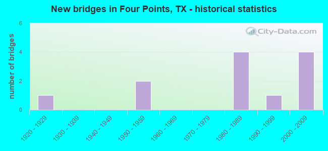
- New bridges - historical statistics
- 11920-1929
- 21950-1959
- 41980-1989
- 11990-1999
- 42000-2009

- Reconstructed bridges - Historical Statistics
- 21970-1979
- 01980-1989
- 01990-1999
- 12000-2009


- Bridge Condition - Channel
- 33.3%Very good
- 66.7%Satisfactory

- Bridge Condition - Culverts
- 33.3%Good
- 66.7%Satisfactory
Find on map >> Show street view
Structure Number: 222400001804028, Location: 5.2 MI N OF US 83 (Lat: 27.826981, Lng: -99.411911), Route carried "on" structure: Interstate 35, Year Built: 1922, Year Reconstructed: 2000, Status: Open, Structure Length: 0.70m (2.30ft), Average Daily Traffic: 16,495 (year 2020), Truck Traffic: 25%, Average Future Daily Traffic: 23,700 (year 2033), Design Load: H 15, Features Intersected: DRAW
Minimum Vertical Clearance: 30+ m (98+ ft), Kilometerpoint: 19.826, Lanes on structure: 8, Base Highway Network: Yes, Owner: State Highway Agency, Approaching Roadway Width: 47.2m (154.9ft), Skew: 29 degrees, Material/Design: Concrete, Design/Construction: Culvert, Number Of Spans In Main Unit: 2, Length of Maximum Span: 3.0m (9.8ft)
Condition: Channel: Satisfactory, Culverts: Satisfactory, Operating Rating: 39.9 metric tons, Method Used To Determine Operating Rating: Load Factor (LF), Inventory Rating: 23.6 metric tons, Method Used To Determine Inventory Rating: Load Factor (LF), Structural Evaluation: Somewhat better than minimum adequacy, Waterway Adequacy: Equal to present minimum criteria, Approach Roadway Alignment: Equal to present desirable criteria, Designated Inspection Frequency: Every 24 months, Inspection Date: November 2020
Find on map >> Show street view
Structure Number: 222400001804064, Location: 3.80 MI N OF US 83 (Lat: 27.806800, Lng: -99.417575), Route carried "on" structure: Interstate 35, Year Built: 1958, Year Reconstructed: 1982, Status: Open, Structure Length: 1.31m (4.30ft), Average Daily Traffic: 16,495 (year 2020), Truck Traffic: 25%, Average Future Daily Traffic: 23,700 (year 2033), Features Intersected: DRAW
Minimum Vertical Clearance: 30+ m (98+ ft), Kilometerpoint: 17.521, Lanes on structure: 8, Base Highway Network: Yes, Owner: State Highway Agency, Approaching Roadway Width: 40.2m (131.9ft), Material/Design: Concrete, Design/Construction: Culvert, Number Of Spans In Main Unit: 4, Length of Maximum Span: 3.0m (9.8ft), Curb-To-Curb Width: 42.7m (140.1ft), Out-to-Out Width: 78.9m (258.9ft)
Condition: Channel: Very good, Culverts: Satisfactory, Operating Rating: 39.9 metric tons, Method Used To Determine Operating Rating: Load Factor (LF), Inventory Rating: 23.6 metric tons, Method Used To Determine Inventory Rating: Load Factor (LF), Structural Evaluation: Somewhat better than minimum adequacy, Deck Geometry: Superior to present desirable criteria, Waterway Adequacy: Equal to present minimum criteria, Approach Roadway Alignment: Equal to present desirable criteria, Designated Inspection Frequency: Every 24 months, Inspection Date: November 2020, Deck Structure Type: Concrete Cast-file-Place, Wearing Surface/Protective System: Wearing Surface: Bituminous
Find on map >> Show street view
Structure Number: 222400001804065, Location: 3.35 MI N OF US 83 (Lat: 27.800600, Lng: -99.419233), Route carried "on" structure: Interstate 35, Year Built: 1958, Year Reconstructed: 1982, Status: Open, Structure Length: 0.91m (2.99ft), Average Daily Traffic: 16,495 (year 2020), Truck Traffic: 25%, Average Future Daily Traffic: 23,700 (year 2033), Features Intersected: DRAW
Minimum Vertical Clearance: 30+ m (98+ ft), Kilometerpoint: 16.818, Lanes on structure: 8, Base Highway Network: Yes, Owner: State Highway Agency, Approaching Roadway Width: 42.4m (139.1ft), Material/Design: Concrete, Design/Construction: Culvert, Number Of Spans In Main Unit: 3, Length of Maximum Span: 2.7m (8.9ft), Curb-To-Curb Width: 47.2m (154.9ft), Out-to-Out Width: 91.4m (299.9ft)
Condition: Channel: Satisfactory, Culverts: Good, Operating Rating: 39.9 metric tons, Method Used To Determine Operating Rating: Load Factor (LF), Inventory Rating: 23.6 metric tons, Method Used To Determine Inventory Rating: Load Factor (LF), Structural Evaluation: Somewhat better than minimum adequacy, Deck Geometry: Superior to present desirable criteria, Waterway Adequacy: Equal to present minimum criteria, Approach Roadway Alignment: Equal to present desirable criteria, Designated Inspection Frequency: Every 24 months, Inspection Date: November 2020, Deck Structure Type: Concrete Cast-file-Place, Wearing Surface/Protective System: Wearing Surface: Bituminous
Find on map >> Show street view
Structure Number: 222400001804152, Location: 2.80 MI N OF US 83 (Lat: 27.795008, Lng: -99.421081), Route carried "on" structure: Interstate 35, Year Built: 1982, Status: Open, Structure Length: 3.96m (12.99ft), Average Daily Traffic: 9,869 (year 2019), Truck Traffic: 25%, Average Future Daily Traffic: 11,850 (year 2033), Design Load: HS 20, Features Intersected: WEBB INTERCHANGE
Minimum Vertical Clearance: 30+ m (98+ ft), Kilometerpoint: 16.140, Lanes on structure: 2, Lanes under structure: 2, Base Highway Network: Yes, Owner: State Highway Agency, Approaching Roadway Width: 11.6m (38.1ft), Material/Design: Prestressed concrete, Design/Construction: Stringer/Multi-beam, Number Of Spans In Main Unit: 3, Length of Maximum Span: 15.2m (49.9ft), Curb-To-Curb Width: 11.6m (38.1ft), Out-to-Out Width: 12.1m (39.7ft)
Condition: Deck: Good, Superstructure: Good, Substructure: Good, Operating Rating: 54.4 metric tons, Method Used To Determine Operating Rating: Assigned rating based on Load Factor Design (LFD) reported in metric tons, Inventory Rating: 32.7 metric tons, Method Used To Determine Inventory Rating: Assigned rating based on Load Factor Design (LFD) reported in metric tons, Structural Evaluation: Better than present minimum criteria, Deck Geometry: Equal to present minimum criteria, Underclear: Better than present minimum criteria, Approach Roadway Alignment: Equal to present desirable criteria, Designated Inspection Frequency: Every 24 months, Inspection Date: November 2020, Deck Structure Type: Concrete Cast-file-Place
Find on map >> Show street view
Structure Number: 222400001804153, Location: 2.80 MI N OF US 83 (Lat: 27.794636, Lng: -99.420842), Route carried "on" structure: Interstate 35, Year Built: 1982, Status: Open, Structure Length: 3.96m (12.99ft), Average Daily Traffic: 9,768 (year 2019), Truck Traffic: 25%, Average Future Daily Traffic: 11,850 (year 2033), Design Load: HS 20, Features Intersected: WEBB INTERCHANGE
Minimum Vertical Clearance: 30+ m (98+ ft), Kilometerpoint: 16.140, Lanes on structure: 2, Lanes under structure: 2, Base Highway Network: Yes, Owner: State Highway Agency, Approaching Roadway Width: 11.6m (38.1ft), Material/Design: Prestressed concrete, Design/Construction: Stringer/Multi-beam, Number Of Spans In Main Unit: 3, Length of Maximum Span: 15.2m (49.9ft), Curb-To-Curb Width: 11.6m (38.1ft), Out-to-Out Width: 12.1m (39.7ft)
Condition: Deck: Good, Superstructure: Good, Substructure: Good, Operating Rating: 54.4 metric tons, Method Used To Determine Operating Rating: Assigned rating based on Load Factor Design (LFD) reported in metric tons, Inventory Rating: 32.7 metric tons, Method Used To Determine Inventory Rating: Assigned rating based on Load Factor Design (LFD) reported in metric tons, Structural Evaluation: Better than present minimum criteria, Deck Geometry: Equal to present minimum criteria, Underclear: Better than present minimum criteria, Approach Roadway Alignment: Equal to present desirable criteria, Designated Inspection Frequency: Every 24 months, Inspection Date: November 2020, Deck Structure Type: Concrete Cast-file-Place
Find on map >> Show street view
Structure Number: 222400001804171, Location: 5.30 MI N OF US 83 (Lat: 27.829022, Lng: -99.410681), Route carried "on" structure: Other road 255, Year Built: 2001, Status: Open, Structure Length: 7.83m (25.69ft), Average Daily Traffic: 630 (year 2013), Truck Traffic: 21%, Average Future Daily Traffic: 980 (year 2033), Design Load: HS 25 or greater, Features Intersected: IH 35
Minimum Vertical Clearance: 30+ m (98+ ft), Kilometerpoint: 36.107, Lanes on structure: 2, Lanes under structure: 4, Toll: On toll road, Owner: State Highway Agency, Approaching Roadway Width: 25.6m (84.0ft), Skew: 1 degrees, Material/Design: Prestressed concrete, Design/Construction: Stringer/Multi-beam, Number Of Spans In Main Unit: 2, Number Of Approach Spans: 1, Length of Maximum Span: 29.0m (95.1ft), Curb-To-Curb Width: 25.4m (83.3ft), Out-to-Out Width: 26.9m (88.3ft)
Condition: Deck: Good, Superstructure: Good, Substructure: Good, Operating Rating: 54.4 metric tons, Method Used To Determine Operating Rating: Assigned rating based on Load Factor Design (LFD) reported in metric tons, Inventory Rating: 40.8 metric tons, Method Used To Determine Inventory Rating: Assigned rating based on Load Factor Design (LFD) reported in metric tons, Structural Evaluation: Better than present minimum criteria, Deck Geometry: Superior to present desirable criteria, Underclear: Equal to present minimum criteria, Approach Roadway Alignment: Equal to present desirable criteria, Designated Inspection Frequency: Every 24 months, Inspection Date: November 2020, Deck Structure Type: Concrete Cast-file-Place
Find on map >> Show street view
Structure Number: 222400001804172, Location: 5.30 MI N OF US 83 (Lat: 27.831575, Lng: -99.410817), Route carried "on" structure: ServiceInterstate 35, Year Built: 2001, Status: Open, Structure Length: 27.49m (90.19ft), Average Daily Traffic: 60 (year 2013), Truck Traffic: 23%, Average Future Daily Traffic: 80 (year 2033), Design Load: HS 25 or greater, Features Intersected: RIGHT OF WAY @ SH 255
Minimum Vertical Clearance: 30+ m (98+ ft), Kilometerpoint: 18.129, Lanes on structure: 2, Owner: State Highway Agency, Approaching Roadway Width: 12.2m (40.0ft), Material/Design: Prestressed concrete, Design/Construction: Stringer/Multi-beam, Number Of Spans In Main Unit: 8, Length of Maximum Span: 35.1m (115.2ft), Curb-To-Curb Width: 12.2m (40.0ft), Out-to-Out Width: 12.9m (42.3ft)
Condition: Deck: Good, Superstructure: Good, Substructure: Good, Operating Rating: 54.4 metric tons, Method Used To Determine Operating Rating: Assigned rating based on Load Factor Design (LFD) reported in metric tons, Inventory Rating: 40.8 metric tons, Method Used To Determine Inventory Rating: Assigned rating based on Load Factor Design (LFD) reported in metric tons, Structural Evaluation: Better than present minimum criteria, Deck Geometry: Superior to present desirable criteria, Approach Roadway Alignment: Equal to present desirable criteria, Designated Inspection Frequency: Every 24 months, Inspection Date: November 2020, Deck Structure Type: Concrete Cast-file-Place
Find on map >> Show street view
Structure Number: 222400001804173, Location: 5.30 MI N OF US 83 (Lat: 27.828628, Lng: -99.411703), Route carried "on" structure: ServiceInterstate 35, Year Built: 2001, Status: Open, Structure Length: 13.69m (44.91ft), Average Daily Traffic: 10 (year 2013), Average Future Daily Traffic: 10 (year 2033), Design Load: HS 25 or greater, Features Intersected: ROW TERRAIN
Minimum Vertical Clearance: 30+ m (98+ ft), Kilometerpoint: 17.859, Lanes on structure: 2, Owner: State Highway Agency, Approaching Roadway Width: 12.2m (40.0ft), Material/Design: Prestressed concrete, Design/Construction: Stringer/Multi-beam, Number Of Spans In Main Unit: 4, Length of Maximum Span: 35.1m (115.2ft), Curb-To-Curb Width: 11.9m (39.0ft), Out-to-Out Width: 12.8m (42.0ft)
Condition: Deck: Good, Superstructure: Good, Substructure: Good, Operating Rating: 54.4 metric tons, Method Used To Determine Operating Rating: Assigned rating based on Load Factor Design (LFD) reported in metric tons, Inventory Rating: 40.8 metric tons, Method Used To Determine Inventory Rating: Assigned rating based on Load Factor Design (LFD) reported in metric tons, Structural Evaluation: Better than present minimum criteria, Deck Geometry: Superior to present desirable criteria, Approach Roadway Alignment: Equal to present desirable criteria, Designated Inspection Frequency: Every 24 months, Inspection Date: November 2020, Deck Structure Type: Concrete Cast-file-Place
Find on map >> Show street view
Structure Number: 222400358602021, Location: 0.12 MI WEST OF IH35 (Lat: 27.829053, Lng: -99.411739), Route carried "on" structure: Other road 255, Year Built: 1999, Status: Open, Structure Length: 14.17m (46.49ft), Average Daily Traffic: 630 (year 2010), Truck Traffic: 21%, Average Future Daily Traffic: 980 (year 2030), Design Load: HS 25 or greater, Features Intersected: UPRR
Minimum Vertical Clearance: 30+ m (98+ ft), Kilometerpoint: 35.941, Lanes on structure: 2, Toll: On toll road, Owner: State Highway Agency, Approaching Roadway Width: 25.6m (84.0ft), Skew: 1 degrees, Material/Design: Prestressed concrete, Design/Construction: Stringer/Multi-beam, Number Of Spans In Main Unit: 4, Length of Maximum Span: 35.7m (117.1ft), Curb-To-Curb Width: 25.5m (83.7ft), Out-to-Out Width: 26.3m (86.3ft)
Condition: Deck: Good, Superstructure: Good, Substructure: Good, Operating Rating: 54.4 metric tons, Method Used To Determine Operating Rating: Assigned rating based on Load Factor Design (LFD) reported in metric tons, Inventory Rating: 40.8 metric tons, Method Used To Determine Inventory Rating: Assigned rating based on Load Factor Design (LFD) reported in metric tons, Structural Evaluation: Better than present minimum criteria, Deck Geometry: Superior to present desirable criteria, Underclear: Superior to present desirable criteria, Approach Roadway Alignment: Equal to present desirable criteria, Designated Inspection Frequency: Every 24 months, Inspection Date: September 2020, Deck Structure Type: Concrete Precast Panels
Find on map >> Show street view
Structure Number: 222400001804152, Location: 2.80 MI N OF US 83 (Lat: 27.794861, Lng: -99.421061), Route carried "under" structure: County highway , Year Built: 1982, Structure Length: 0. m, Average Daily Traffic: 50 (year 2013), Truck Traffic: 1%, Features Intersected: WEBB INTERCHANGE, Facility Carried by Structure: IH 35 SBML
Minimum Vertical Clearance: 5.11m (16.77ft), Kilometerpoint: 0.000, Lanes on structure: 2, Lanes under structure: 2, Material/Design: Prestressed concrete, Design/Construction: Stringer/Multi-beam, Length of Maximum Span: 15.2m (49.9ft)
Find on map >> Show street view
Structure Number: 222400001804153, Location: 2.80 MI N OF US 83 (Lat: 27.794811, Lng: -99.420861), Route carried "under" structure: County highway , Year Built: 1982, Structure Length: 0. m, Average Daily Traffic: 50 (year 2013), Truck Traffic: 1%, Features Intersected: WEBB INTERCHANGE, Facility Carried by Structure: IH 35 NBML
Minimum Vertical Clearance: 5.08m (16.67ft), Kilometerpoint: 0.000, Lanes on structure: 2, Lanes under structure: 2, Material/Design: Prestressed concrete, Design/Construction: Stringer/Multi-beam, Length of Maximum Span: 15.2m (49.9ft)
Find on map >> Show street view
Structure Number: 222400001804171, Location: 5.30 MI N OF US 83 (Lat: 27.828919, Lng: -99.411339), Route carried "under" structure: Interstate 35, Year Built: 2001, Structure Length: 0. m, Average Daily Traffic: 13,320 (year 2013), Truck Traffic: 28%, Features Intersected: IH 35, Facility Carried by Structure: SH 255 TOLL ROAD
Minimum Vertical Clearance: 8.05m (26.41ft), Kilometerpoint: 17.959, Lanes on structure: 2, Lanes under structure: 4, Material/Design: Prestressed concrete, Design/Construction: Stringer/Multi-beam, Length of Maximum Span: 29.0m (95.1ft)