Bridge Statistics for Fowler, California (CA)
Condition, Traffic, Stress, Structural Evaluation, Project Costs
- National Bridge Inventory (NBI) Statistics
- 11Number of bridges
- 167ft / 51.3mTotal length
- 361,484Total average daily traffic
- 81,854Total average daily truck traffic
- National Bridge Inventory (NBI) Registered Bridges for Fowler
- No street view available for this location
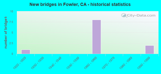
- New bridges - historical statistics
- 11920-1929
- 81960-1969
- 21990-1999
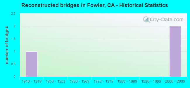
- Reconstructed bridges - Historical Statistics
- 11940-1949
- 01950-1959
- 01960-1969
- 01970-1979
- 01980-1989
- 01990-1999
- 22000-2009
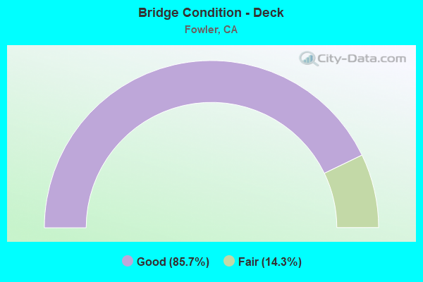
- Bridge Condition - Deck
- 85.7%Good
- 14.3%Fair
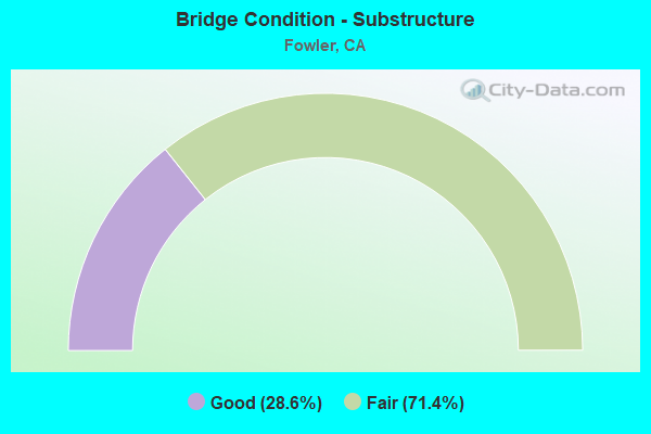
- Bridge Condition - Substructure
- 28.6%Good
- 71.4%Fair
Find on map >> Show street view
Structure Number: 42 0200K, Location: 06-FRE-099-6.50-SEL (Lat: 36.576503, Lng: -119.629928), Route carried "on" structure: Bypass State highway 99, Year Built: 1962, Status: Open, Structure Length: 4.33m (14.21ft), Average Daily Traffic: 7,980 (year 2015), Truck Traffic: 18%, Average Future Daily Traffic: 12,443 (year 2039), Design Load: HS 20+Mod, Features Intersected: FLORAL AVE
Minimum Vertical Clearance: 30+ m (98+ ft), Kilometerpoint: 6.500, Lanes on structure: 1, Lanes under structure: 5, Base Highway Network: Yes (, Subroute: 1), Owner: State Highway Agency, Approaching Roadway Width: 6.7m (22.0ft), Skew: 2 degrees, Material/Design: Concrete continuous, Design/Construction: Box Beam or Girders - Multiple, Number Of Spans In Main Unit: 3, Length of Maximum Span: 21.0m (68.9ft), Curb or Sidewalk Widths: Left: 0.0m, Right: 0.6m (2.0ft), Curb-To-Curb Width: 6.7m (22.0ft), Out-to-Out Width: 8.0m (26.2ft)
Condition: Deck: Fair, Superstructure: Good, Substructure: Fair, Operating Rating: 53.1 metric tons, Method Used To Determine Operating Rating: Load and Resistance Factor Rating (LRFR) rating reported by rating factor(RF) method using HL-93 loadings, Inventory Rating: 39.2 metric tons, Method Used To Determine Inventory Rating: Load and Resistance Factor Rating (LRFR) rating reported by rating factor(RF) method using HL-93 loadings, Structural Evaluation: Somewhat better than minimum adequacy, Deck Geometry: High priority of replacement, Underclear: Equal to present minimum criteria, Approach Roadway Alignment: Equal to present desirable criteria, Designated Inspection Frequency: Every 24 months, Inspection Date: April 2021, Deck Structure Type: Concrete Cast-file-Place
Find on map >> Show street view
Structure Number: 42 0201, Location: 06-FRE-099-9.16-FOW (Lat: 36.605344, Lng: -119.661714), Route carried "on" structure: County highway Z462, Year Built: 1962, Status: Open, Structure Length: 9.85m (32.32ft), Average Daily Traffic: 16,894 (year 2015), Truck Traffic: 15%, Average Future Daily Traffic: 20,694 (year 2039), Design Load: HS 20+Mod, Features Intersected: STATE ROUTE 99, Facility Carried by Structure: MANNING AVE
Minimum Vertical Clearance: 30+ m (98+ ft), Kilometerpoint: 0.000, Lanes on structure: 3, Lanes under structure: 7, Owner: State Highway Agency, Approaching Roadway Width: 14.6m (47.9ft), Skew: 4 degrees, Material/Design: Concrete continuous, Design/Construction: Box Beam or Girders - Multiple, Number Of Spans In Main Unit: 4, Length of Maximum Span: 29.3m (96.1ft), Curb or Sidewalk Widths: Left: 1.5m (4.9ft), Right: 0.0m, Curb-To-Curb Width: 13.4m (44.0ft), Out-to-Out Width: 15.6m (51.2ft)
Condition: Deck: Good, Superstructure: Good, Substructure: Fair, Operating Rating: 41.1 metric tons, Method Used To Determine Operating Rating: Load and Resistance Factor Rating (LRFR) rating reported by rating factor(RF) method using HL-93 loadings, Inventory Rating: 29.5 metric tons, Method Used To Determine Inventory Rating: Load and Resistance Factor Rating (LRFR) rating reported by rating factor(RF) method using HL-93 loadings, Structural Evaluation: Somewhat better than minimum adequacy, Deck Geometry: Somewhat better than minimum adequacy, Underclear: Somewhat better than minimum adequacy, Approach Roadway Alignment: Equal to present desirable criteria, Designated Inspection Frequency: Every 24 months, Inspection Date: April 2021, Deck Structure Type: Concrete Cast-file-Place, Wearing Surface/Protective System: Wearing Surface: Bituminous
Find on map >> Show street view
Structure Number: 42 0202, Location: 06-FRE-099-11.10-FOW (Lat: 36.626578, Lng: -119.684028), Route carried "on" structure: State highway 99, Year Built: 1962, Year Reconstructed: 2006, Status: Open, Structure Length: 4.97m (16.31ft), Average Daily Traffic: 78,000 (year 2009), Truck Traffic: 24%, Average Future Daily Traffic: 121,600 (year 2043), Design Load: HS 20+Mod, Features Intersected: MERCED STREET
Minimum Vertical Clearance: 30+ m (98+ ft), Kilometerpoint: 11.100, Lanes on structure: 6, Lanes under structure: 3, Base Highway Network: Yes (, Subroute: 1), Owner: State Highway Agency, Approaching Roadway Width: 41.0m (134.5ft), Skew: 30 degrees, Material/Design: Concrete continuous, Design/Construction: Box Beam or Girders - Multiple, Number Of Spans In Main Unit: 3, Length of Maximum Span: 25.3m (83.0ft), Curb-To-Curb Width: 41.0m (134.5ft), Out-to-Out Width: 42.5m (139.4ft)
Condition: Deck: Good, Superstructure: Good, Substructure: Good, Operating Rating: 54.1 metric tons, Method Used To Determine Operating Rating: Assigned rating based on Load Factor Design (LFD) reported in metric tons, Inventory Rating: 32.4 metric tons, Method Used To Determine Inventory Rating: Assigned rating based on Load Factor Design (LFD) reported in metric tons, Structural Evaluation: Better than present minimum criteria, Deck Geometry: Superior to present desirable criteria, Underclear: Somewhat better than minimum adequacy, Approach Roadway Alignment: Equal to present desirable criteria, Designated Inspection Frequency: Every 24 months, Inspection Date: April 2021, Deck Structure Type: Concrete Cast-file-Place, Wearing Surface/Protective System: Wearing Surface: Integral Concrete
Find on map >> Show street view
Structure Number: 42 0203, Location: 06-FRE-099-11.84-FOW (Lat: 36.634422, Lng: -119.693550), Route carried "on" structure: County highway , Year Built: 1962, Status: Open, Structure Length: 9.91m (32.51ft), Average Daily Traffic: 2,750 (year 2017), Truck Traffic: 15%, Average Future Daily Traffic: 3,978 (year 2043), Design Load: HS 20+Mod, Features Intersected: STATE ROUTE 99, Facility Carried by Structure: ADAMS AVENUE
Minimum Vertical Clearance: 30+ m (98+ ft), Kilometerpoint: 0.000, Lanes on structure: 2, Lanes under structure: 7, Owner: State Highway Agency, Approaching Roadway Width: 12.5m (41.0ft), Skew: 4 degrees, Material/Design: Concrete continuous, Design/Construction: Box Beam or Girders - Multiple, Number Of Spans In Main Unit: 4, Length of Maximum Span: 29.9m (98.1ft), Curb or Sidewalk Widths: Left: 0.0m, Right: 1.5m (4.9ft), Curb-To-Curb Width: 9.8m (32.2ft), Out-to-Out Width: 12.0m (39.4ft)
Condition: Deck: Good, Superstructure: Good, Substructure: Fair, Operating Rating: 43.1 metric tons, Method Used To Determine Operating Rating: Load and Resistance Factor Rating (LRFR) rating reported by rating factor(RF) method using HL-93 loadings, Inventory Rating: 30.8 metric tons, Method Used To Determine Inventory Rating: Load and Resistance Factor Rating (LRFR) rating reported by rating factor(RF) method using HL-93 loadings, Structural Evaluation: Somewhat better than minimum adequacy, Deck Geometry: Meets minimum limits, Underclear: Somewhat better than minimum adequacy, Approach Roadway Alignment: Equal to present desirable criteria, Designated Inspection Frequency: Every 24 months, Inspection Date: April 2021, Deck Structure Type: Concrete Cast-file-Place
Find on map >> Show street view
Structure Number: 42 0204, Location: 06-FRE-099-12.40 (Lat: 36.640928, Lng: -119.699767), Route carried "on" structure: State highway 99, Year Built: 1962, Year Reconstructed: 2006, Status: Open, Structure Length: 7.45m (24.44ft), Average Daily Traffic: 78,000 (year 2009), Truck Traffic: 24%, Average Future Daily Traffic: 121,600 (year 2043), Design Load: HS 20+Mod, Features Intersected: CLOVIS AVENUE
Minimum Vertical Clearance: 30+ m (98+ ft), Kilometerpoint: 12.400, Lanes on structure: 6, Lanes under structure: 4, Base Highway Network: Yes (, Subroute: 1), Owner: State Highway Agency, Approaching Roadway Width: 41.0m (134.5ft), Skew: 34 degrees, Material/Design: Concrete continuous, Design/Construction: Box Beam or Girders - Multiple, Number Of Spans In Main Unit: 4, Length of Maximum Span: 21.8m (71.5ft), Curb-To-Curb Width: 41.0m (134.5ft), Out-to-Out Width: 42.5m (139.4ft)
Condition: Deck: Good, Superstructure: Good, Substructure: Good, Operating Rating: 54.1 metric tons, Method Used To Determine Operating Rating: Assigned rating based on Load Factor Design (LFD) reported in metric tons, Inventory Rating: 32.4 metric tons, Method Used To Determine Inventory Rating: Assigned rating based on Load Factor Design (LFD) reported in metric tons, Structural Evaluation: Better than present minimum criteria, Deck Geometry: Superior to present desirable criteria, Underclear: Equal to present minimum criteria, Approach Roadway Alignment: Equal to present desirable criteria, Designated Inspection Frequency: Every 24 months, Inspection Date: April 2021, Deck Structure Type: Concrete Cast-file-Place, Wearing Surface/Protective System: Wearing Surface: Integral Concrete
Find on map >> Show street view
Structure Number: 42C017, Location: 0.4 MI S OF FLORAL AVE (Lat: 36.571194, Lng: -119.682458), Route carried "on" structure: County highway , Year Built: 1925, Year Reconstructed: 1948, Status: Open, Structure Length: 1.50m (4.92ft), Average Daily Traffic: 2,300 (year 2012), Truck Traffic: 10%, Average Future Daily Traffic: 6,675 (year 2042), Features Intersected: FOWLER SWITCH CANAL, Facility Carried by Structure: S FOWLER AVE
Minimum Vertical Clearance: 30+ m (98+ ft), Kilometerpoint: 0.000, Lanes on structure: 2, Owner: County Highway Agency, Approaching Roadway Width: 7.9m (25.9ft), Material/Design: Concrete continuous, Design/Construction: Slab, Number Of Spans In Main Unit: 3, Length of Maximum Span: 4.9m (16.1ft), Curb or Sidewalk Widths: Left: 0.2m (0.7ft), Right: 0.2m (0.7ft), Curb-To-Curb Width: 7.9m (25.9ft), Out-to-Out Width: 8.7m (28.5ft)
Condition: Deck: Good, Superstructure: Good, Substructure: Fair, Channel: Good, Operating Rating: 26.9 metric tons, Method Used To Determine Operating Rating: Field evaluation and documented engineering judgment, Inventory Rating: 16.2 metric tons, Method Used To Determine Inventory Rating: Field evaluation and documented engineering judgment, Structural Evaluation: Meets minimum limits, Deck Geometry: High priority of corrective action, Waterway Adequacy: Equal to present desirable criteria, Approach Roadway Alignment: Equal to present desirable criteria, Designated Inspection Frequency: Every 24 months, Inspection Date: January 2022, Deck Structure Type: Concrete Cast-file-Place, Wearing Surface/Protective System: Wearing Surface: Bituminous
Find on map >> Show street view
Structure Number: 42C0609, Location: 0.4 MI NORTH OF SR 99 (Lat: 36.646136, Lng: -119.699858), Route carried "on" structure: County highway , Year Built: 1997, Status: Open, Structure Length: 13.25m (43.47ft), Average Daily Traffic: 10,600 (year 2005), Truck Traffic: 10%, Average Future Daily Traffic: 24,209 (year 2042), Design Load: HS 20+Mod, Features Intersected: UP RR & GOLDEN STATE BL, Facility Carried by Structure: S CLOVIS AVE
Minimum Vertical Clearance: 30+ m (98+ ft), Kilometerpoint: 0.000, Lanes on structure: 4, Lanes under structure: 4, Owner: County Highway Agency, Approaching Roadway Width: 20.8m (68.2ft), Skew: 34 degrees, Material/Design: Prestressed concrete continuous, Design/Construction: Box Beam or Girders - Multiple, Number Of Spans In Main Unit: 4, Length of Maximum Span: 39.6m (129.9ft), Curb or Sidewalk Widths: Left: 1.5m (4.9ft), Right: 1.5m (4.9ft), Curb-To-Curb Width: 20.8m (68.2ft), Out-to-Out Width: 26.6m (87.3ft)
Condition: Deck: Good, Superstructure: Good, Substructure: Fair, Operating Rating: 54.1 metric tons, Method Used To Determine Operating Rating: Assigned rating based on Load Factor Design (LFD) reported in metric tons, Inventory Rating: 32.4 metric tons, Method Used To Determine Inventory Rating: Assigned rating based on Load Factor Design (LFD) reported in metric tons, Structural Evaluation: Somewhat better than minimum adequacy, Deck Geometry: Superior to present desirable criteria, Underclear: Meets minimum limits, Approach Roadway Alignment: Equal to present desirable criteria, Designated Inspection Frequency: Every 24 months, Inspection Date: January 2022, Deck Structure Type: Concrete Cast-file-Place
Find on map >> Show street view
Structure Number: 42 0201, Location: 06-FRE-099-9.16-FOW (Lat: 36.605344, Lng: -119.661714), Route carried "under" structure: State highway 99, Year Built: 1962, Structure Length: 0. m, Average Daily Traffic: 78,000 (year 2009), Truck Traffic: 24%, Features Intersected: STATE ROUTE 99, Facility Carried by Structure: MANNING AVE
Minimum Vertical Clearance: 4.67m (15.32ft), Kilometerpoint: 9.160, Lanes on structure: 3, Lanes under structure: 7, Material/Design: Concrete continuous, Design/Construction: Box Beam or Girders - Multiple, Length of Maximum Span: 29.3m (96.1ft)
Find on map >> Show street view
Structure Number: 42 0202, Location: 06-FRE-099-11.10-FOW (Lat: 36.626578, Lng: -119.684028), Route carried "under" structure: City street , Year Built: 1962, Structure Length: 0. m, Average Daily Traffic: 4,060 (year 2015), Truck Traffic: 20%, Features Intersected: MERCED STREET, Facility Carried by Structure: STATE ROUTE 99
Minimum Vertical Clearance: 4.49m (14.73ft), Kilometerpoint: 0.000, Lanes on structure: 6, Lanes under structure: 3, Material/Design: Concrete continuous, Design/Construction: Box Beam or Girders - Multiple, Length of Maximum Span: 25.3m (83.0ft)
Find on map >> Show street view
Structure Number: 42 0203, Location: 06-FRE-099-11.84-FOW (Lat: 36.634422, Lng: -119.693550), Route carried "under" structure: State highway 99, Year Built: 1962, Structure Length: 0. m, Average Daily Traffic: 78,000 (year 2009), Truck Traffic: 24%, Features Intersected: STATE ROUTE 99, Facility Carried by Structure: ADAMS AVENUE
Minimum Vertical Clearance: 4.64m (15.22ft), Kilometerpoint: 11.840, Lanes on structure: 2, Lanes under structure: 7, Material/Design: Concrete continuous, Design/Construction: Box Beam or Girders - Multiple, Length of Maximum Span: 29.9m (98.1ft)
Find on map >> Show street view
Structure Number: 42C0609, Location: 0.4 MI NORTH OF SR 99 (Lat: 36.646136, Lng: -119.699858), Route carried "under" structure: County highway , Year Built: 1997, Structure Length: 0. m, Average Daily Traffic: 4,900 (year 2010), Truck Traffic: 10%, Features Intersected: UP RR & GOLDEN STATE BL, Facility Carried by Structure: S CLOVIS AVE
Minimum Vertical Clearance: 6.05m (19.85ft), Kilometerpoint: 0.000, Lanes on structure: 4, Lanes under structure: 4, Material/Design: Prestressed concrete continuous, Design/Construction: Box Beam or Girders - Multiple, Length of Maximum Span: 39.6m (129.9ft)