Bridge Statistics for Fredericktown, Missouri (MO)
Condition, Traffic, Stress, Structural Evaluation, Project Costs
- National Bridge Inventory (NBI) Statistics
- 32Number of bridges
- 331ft / 101mTotal length
- $3,391,000Total costs
- 79,718Total average daily traffic
- 11,758Total average daily truck traffic
- National Bridge Inventory (NBI) Registered Bridges for Fredericktown
- No street view available for this location
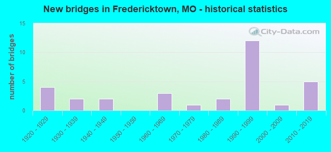
- New bridges - historical statistics
- 41920-1929
- 21930-1939
- 21940-1949
- 31960-1969
- 11970-1979
- 21980-1989
- 121990-1999
- 12000-2009
- 52010-2019

- Reconstructed bridges - Historical Statistics
- 11950-1959
- 01960-1969
- 11970-1979
- 11980-1989


- Bridge Condition - Deck
- 11.1%Excellent
- 5.6%Very good
- 50.0%Good
- 5.6%Satisfactory
- 11.1%Fair
- 16.7%Poor

- Bridge Condition - Superstructure
- 16.7%Excellent
- 44.4%Very good
- 11.1%Good
- 5.6%Fair
- 16.7%Poor
- 5.6%Serious

- Bridge Condition - Substructure
- 5.6%Excellent
- 44.4%Very good
- 22.2%Good
- 16.7%Satisfactory
- 5.6%Fair
- 5.6%Poor

- Bridge Condition - Channel
- 4.5%Excellent
- 54.5%Good
- 18.2%Satisfactory
- 18.2%Fair
- 4.5%Serious

- Bridge Condition - Culverts
- 12.5%Very good
- 12.5%Good
- 37.5%Satisfactory
- 25.0%Fair
- 12.5%Serious
Find on map >> Show street view
Structure Number: 11815, Location: S 2135 T 33 N R 7 E (Lat: 37.521903, Lng: -90.316400), Route carried "on" structure: State highway E, Year Built: 1999, Status: Open, Structure Length: 0.79m (2.59ft), Average Daily Traffic: 1,125 (year 2021), Truck Traffic: 11%, Average Future Daily Traffic: 1,575 (year 2041), Design Load: HS 20, Features Intersected: MILL CR TRIB
Minimum Vertical Clearance: 30+ m (98+ ft), Kilometerpoint: 45.079, Lanes on structure: 3, Owner: State Highway Agency, Approaching Roadway Width: 15.5m (50.9ft), Skew: 4 degrees, Material/Design: Concrete continuous, Design/Construction: Culvert, Number Of Spans In Main Unit: 2, Length of Maximum Span: 2.4m (7.9ft)
Condition: Channel: Good, Culverts: Very good, Inventory Rating: 93.6 metric tons, Method Used To Determine Inventory Rating: Load Factor (LF), Structural Evaluation: Equal to present desirable criteria, Waterway Adequacy: Superior to present desirable criteria, Approach Roadway Alignment: Equal to present desirable criteria, Designated Inspection Frequency: Every 24 months, Inspection Date: November 2020
Find on map >> Show street view
Structure Number: 1188, Location: S 350 T 33 N R 7 E (Lat: 37.521722, Lng: -90.313681), Route carried "on" structure: US 67, Year Built: 1999, Status: Open, Structure Length: 4.72m (15.49ft), Average Daily Traffic: 5,330 (year 2021), Truck Traffic: 26%, Average Future Daily Traffic: 9,328 (year 2041), Design Load: HS 25 or greater, Features Intersected: RT E
Minimum Vertical Clearance: 30+ m (98+ ft), Kilometerpoint: 187.812, Lanes on structure: 2, Lanes under structure: 2, Base Highway Network: Yes, Owner: State Highway Agency, Approaching Roadway Width: 11.3m (37.1ft), Skew: 1 degrees, Material/Design: Prestressed concrete continuous, Design/Construction: Stringer/Multi-beam, Number Of Spans In Main Unit: 3, Length of Maximum Span: 21.0m (68.9ft), Curb or Sidewalk Widths: Left: 0.4m (1.3ft), Right: 0.4m (1.3ft), Curb-To-Curb Width: 11.4m (37.4ft), Out-to-Out Width: 12.2m (40.0ft)
Condition: Deck: Good, Superstructure: Very good, Substructure: Very good, Inventory Rating: 64.8 metric tons, Method Used To Determine Inventory Rating: Load Factor (LF), Structural Evaluation: Equal to present desirable criteria, Deck Geometry: Equal to present minimum criteria, Approach Roadway Alignment: Equal to present desirable criteria, Designated Inspection Frequency: Every 24 months, Inspection Date: October 2020, Deck Structure Type: Concrete Cast-file-Place, Wearing Surface/Protective System: Wearing Surface: Monolithic Concrete, Deck Protection: Internally Sealed
Find on map >> Show street view
Structure Number: 11939, Location: S 836 T 33 N R 6 E (Lat: 37.546406, Lng: -90.323786), Route carried "on" structure: US 67, Year Built: 1999, Status: Open, Structure Length: 8.75m (28.71ft), Average Daily Traffic: 5,194 (year 2021), Truck Traffic: 8%, Average Future Daily Traffic: 9,090 (year 2041), Design Load: HS 25 or greater, Features Intersected: LIT ST FRANCOIS RV
Minimum Vertical Clearance: 30+ m (98+ ft), Kilometerpoint: 133.116, Lanes on structure: 2, Base Highway Network: Yes, Owner: State Highway Agency, Approaching Roadway Width: 11.3m (37.1ft), Skew: 4 degrees, Material/Design: Prestressed concrete continuous, Design/Construction: Stringer/Multi-beam, Number Of Spans In Main Unit: 3, Length of Maximum Span: 29.4m (96.5ft), Curb-To-Curb Width: 11.4m (37.4ft), Out-to-Out Width: 12.2m (40.0ft)
Condition: Deck: Good, Superstructure: Very good, Substructure: Very good, Channel: Good, Operating Rating: 93.6 metric tons, Method Used To Determine Operating Rating: Load Factor (LF), Inventory Rating: 43.2 metric tons, Method Used To Determine Inventory Rating: Load Factor (LF), Structural Evaluation: Equal to present desirable criteria, Deck Geometry: Equal to present minimum criteria, Waterway Adequacy: Equal to present desirable criteria, Approach Roadway Alignment: Equal to present desirable criteria, Designated Inspection Frequency: Every 24 months, Inspection Date: October 2020, Deck Structure Type: Concrete Cast-file-Place, Wearing Surface/Protective System: Wearing Surface: Monolithic Concrete, Deck Protection: Internally Sealed
Find on map >> Show street view
Structure Number: 11941, Location: S 836 T 33 N R 6 E (Lat: 37.546406, Lng: -90.324086), Route carried "on" structure: US 67, Year Built: 1999, Status: Open, Structure Length: 8.60m (28.22ft), Average Daily Traffic: 5,330 (year 2021), Truck Traffic: 26%, Average Future Daily Traffic: 9,328 (year 2041), Design Load: HS 25 or greater, Features Intersected: LIT ST FRANCOIS RV
Minimum Vertical Clearance: 30+ m (98+ ft), Kilometerpoint: 184.899, Lanes on structure: 2, Base Highway Network: Yes, Owner: State Highway Agency, Approaching Roadway Width: 11.3m (37.1ft), Skew: 4 degrees, Material/Design: Prestressed concrete continuous, Design/Construction: Stringer/Multi-beam, Number Of Spans In Main Unit: 3, Length of Maximum Span: 28.9m (94.8ft), Curb-To-Curb Width: 11.4m (37.4ft), Out-to-Out Width: 12.2m (40.0ft)
Condition: Deck: Good, Superstructure: Very good, Substructure: Good, Channel: Good, Inventory Rating: 41.4 metric tons, Method Used To Determine Inventory Rating: Load Factor (LF), Structural Evaluation: Better than present minimum criteria, Deck Geometry: Equal to present minimum criteria, Waterway Adequacy: Superior to present desirable criteria, Approach Roadway Alignment: Equal to present desirable criteria, Designated Inspection Frequency: Every 24 months, Inspection Date: October 2020, Deck Structure Type: Concrete Cast-file-Place, Wearing Surface/Protective System: Wearing Surface: Monolithic Concrete, Deck Protection: Internally Sealed
Find on map >> Show street view
Structure Number: 12076, Location: S 836 T 33 N R 6 E (Lat: 37.539708, Lng: -90.321153), Route carried "on" structure: County highway 500, Year Built: 1999, Status: Open, Structure Length: 7.62m (25.00ft), Average Daily Traffic: 50 (year 2021), Truck Traffic: 8%, Average Future Daily Traffic: 70 (year 2041), Design Load: HS 20, Features Intersected: US 67
Minimum Vertical Clearance: 30+ m (98+ ft), Kilometerpoint: 0.666, Lanes on structure: 2, Lanes under structure: 4, Owner: State Highway Agency, Approaching Roadway Width: 8.2m (26.9ft), Skew: 1 degrees, Material/Design: Steel continuous, Design/Construction: Stringer/Multi-beam, Number Of Spans In Main Unit: 2, Length of Maximum Span: 34.4m (112.9ft), Curb-To-Curb Width: 8.4m (27.6ft), Out-to-Out Width: 9.2m (30.2ft)
Condition: Deck: Good, Superstructure: Excellent, Substructure: Very good, Operating Rating: 72.9 metric tons, Method Used To Determine Operating Rating: Load Factor (LF), Inventory Rating: 44.1 metric tons, Method Used To Determine Inventory Rating: Load Factor (LF), Structural Evaluation: Equal to present desirable criteria, Deck Geometry: Equal to present minimum criteria, Underclear: Better than present minimum criteria, Approach Roadway Alignment: Equal to present desirable criteria, Designated Inspection Frequency: Every 24 months, Inspection Date: October 2020, Deck Structure Type: Concrete Cast-file-Place, Wearing Surface/Protective System: Wearing Surface: Monolithic Concrete, Deck Protection: Internally Sealed
Find on map >> Show street view
Structure Number: 12097, Location: S 350 T 33 N R 7 E (Lat: 37.521706, Lng: -90.313344), Route carried "on" structure: US 67, Year Built: 1999, Status: Open, Structure Length: 4.72m (15.49ft), Average Daily Traffic: 3,651 (year 2021), Truck Traffic: 23%, Average Future Daily Traffic: 6,389 (year 2041), Design Load: HS 25 or greater, Features Intersected: RT E
Minimum Vertical Clearance: 30+ m (98+ ft), Kilometerpoint: 130.241, Lanes on structure: 2, Lanes under structure: 2, Base Highway Network: Yes, Owner: State Highway Agency, Approaching Roadway Width: 11.3m (37.1ft), Skew: 1 degrees, Material/Design: Prestressed concrete continuous, Design/Construction: Stringer/Multi-beam, Number Of Spans In Main Unit: 3, Length of Maximum Span: 21.0m (68.9ft), Curb-To-Curb Width: 11.4m (37.4ft), Out-to-Out Width: 12.2m (40.0ft)
Condition: Deck: Good, Superstructure: Very good, Substructure: Very good, Inventory Rating: 64.8 metric tons, Method Used To Determine Inventory Rating: Load Factor (LF), Structural Evaluation: Equal to present desirable criteria, Deck Geometry: Equal to present minimum criteria, Underclear: Superior to present desirable criteria, Approach Roadway Alignment: Equal to present desirable criteria, Designated Inspection Frequency: Every 24 months, Inspection Date: October 2020, Deck Structure Type: Concrete Cast-file-Place, Wearing Surface/Protective System: Wearing Surface: Monolithic Concrete, Deck Protection: Internally Sealed
Find on map >> Show street view
Structure Number: 13092, Location: S 14 T 33 N R 7 E (Lat: 37.559261, Lng: -90.259800), Route carried "on" structure: County highway 29, Year Built: 1997, Status: Open, Structure Length: 1.83m (6.00ft), Average Daily Traffic: 100 (year 2019), Truck Traffic: 10%, Average Future Daily Traffic: 130 (year 2039), Design Load: HS 20, Features Intersected: SALINE CR, Facility Carried by Structure: COUNTY RD #208
Minimum Vertical Clearance: 30+ m (98+ ft), Kilometerpoint: 0.805, Lanes on structure: 2, Owner: County Highway Agency, Approaching Roadway Width: 5.5m (18.0ft), Material/Design: Prestressed concrete, Design/Construction: Box Beam or Girders - Multiple, Number Of Spans In Main Unit: 1, Length of Maximum Span: 18.3m (60.0ft), Curb-To-Curb Width: 7.3m (24.0ft), Out-to-Out Width: 7.3m (24.0ft)
Condition: Deck: Very good, Superstructure: Very good, Substructure: Satisfactory, Channel: Fair, Operating Rating: 59.4 metric tons, Method Used To Determine Operating Rating: Load Factor (LF), Inventory Rating: 36.9 metric tons, Method Used To Determine Inventory Rating: Load Factor (LF), Structural Evaluation: Equal to present minimum criteria, Deck Geometry: Equal to present minimum criteria, Waterway Adequacy: Superior to present desirable criteria, Approach Roadway Alignment: Somewhat better than minimum adequacy, Designated Inspection Frequency: Every 24 months, Inspection Date: December 2021, Deck Structure Type: Concrete Cast-file-Place, Wearing Surface/Protective System: Wearing Surface: Bituminous
Find on map >> Show street view
Structure Number: 13619, Location: S 25 T 33 N R 6 E (Lat: 37.526667, Lng: -90.313333), Route carried "on" structure: County highway 43, Year Built: 1981, Status: Open, Structure Length: 1.43m (4.69ft), Average Daily Traffic: 35 (year 2019), Truck Traffic: 10%, Average Future Daily Traffic: 46 (year 2039), Features Intersected: MILL CR, Facility Carried by Structure: COUNTY RD #501
Minimum Vertical Clearance: 30+ m (98+ ft), Kilometerpoint: 3.541, Lanes on structure: 2, Owner: County Highway Agency, Approaching Roadway Width: 4.9m (16.1ft), Skew: 1 degrees, Material/Design: Concrete, Design/Construction: Culvert, Number Of Spans In Main Unit: 5, Length of Maximum Span: 2.7m (8.9ft), Curb-To-Curb Width: 5.5m (18.0ft), Out-to-Out Width: 5.8m (19.0ft)
Condition: Channel: Fair, Culverts: Fair, Operating Rating: 49.5 metric tons, Method Used To Determine Operating Rating: Allowable Stress (AS), Inventory Rating: 16.2 metric tons, Method Used To Determine Inventory Rating: Allowable Stress (AS), Structural Evaluation: Somewhat better than minimum adequacy, Deck Geometry: Meets minimum limits, Waterway Adequacy: Somewhat better than minimum adequacy, Approach Roadway Alignment: Somewhat better than minimum adequacy, Designated Inspection Frequency: Every 24 months, Inspection Date: December 2021, Deck Structure Type: Concrete Cast-file-Place, Wearing Surface/Protective System: Wearing Surface: Monolithic Concrete
Find on map >> Show street view
Structure Number: 13807, Location: S 15 T 33 N R 6 E (Lat: 37.540767, Lng: -90.360411), Route carried "on" structure: County highway 48, Year Built: 1928, Status: Open, Structure Length: 0.94m (3.08ft), Average Daily Traffic: 45 (year 2019), Truck Traffic: 10%, Average Future Daily Traffic: 59 (year 2039), Features Intersected: BR LIT ST FRANCIS, Facility Carried by Structure: COUNTY RD #505
Minimum Vertical Clearance: 30+ m (98+ ft), Kilometerpoint: 1.609, Lanes on structure: 1, Owner: County Highway Agency, Approaching Roadway Width: 4.9m (16.1ft), Skew: 2 degrees, Material/Design: Concrete, Design/Construction: Culvert, Number Of Spans In Main Unit: 2, Length of Maximum Span: 5.8m (19.0ft), Curb-To-Curb Width: 5.3m (17.4ft), Out-to-Out Width: 5.3m (17.4ft)
Condition: Channel: Serious, Culverts: Serious, Operating Rating: 49.5 metric tons, Method Used To Determine Operating Rating: Allowable Stress (AS), Inventory Rating: 16.2 metric tons, Method Used To Determine Inventory Rating: Allowable Stress (AS), Structural Evaluation: High priority of corrective action, Deck Geometry: High priority of corrective action, Waterway Adequacy: Somewhat better than minimum adequacy, Approach Roadway Alignment: Meets minimum limits, Length Of Structure Improvement: 0.16m (0.52ft), Designated Inspection Frequency: Every 24 months, Inspection Date: December 2021, Bridge Improvement Cost: $125,000, Roadway Improvement Cost: $13,000, Total Project Cost: $188,000 ( Estimate for 2022), Deck Structure Type: Concrete Cast-file-Place, Wearing Surface/Protective System: Wearing Surface: Monolithic Concrete
Find on map >> Show street view
Structure Number: 13837, Location: S 23 T 33 N R 6 E (Lat: 37.529978, Lng: -90.355269), Route carried "on" structure: County highway 49, Year Built: 1933, Year Reconstructed: 1980, Status: Posted for load, Structure Length: 0.79m (2.59ft), Average Daily Traffic: 30 (year 2019), Truck Traffic: 10%, Average Future Daily Traffic: 39 (year 2039), Features Intersected: BR LIT ST FRANCIS, Facility Carried by Structure: COUNTY RD #503
Minimum Vertical Clearance: 30+ m (98+ ft), Kilometerpoint: 1.287, Lanes on structure: 2, Owner: County Highway Agency, Approaching Roadway Width: 5.5m (18.0ft), Skew: 1 degrees, Material/Design: Concrete, Design/Construction: Slab, Number Of Spans In Main Unit: 2, Length of Maximum Span: 3.8m (12.5ft), Curb-To-Curb Width: 8.8m (28.9ft), Out-to-Out Width: 8.8m (28.9ft)
Condition: Deck: Poor, Superstructure: Poor, Substructure: Poor, Channel: Satisfactory, Operating Rating: 19.8 metric tons, Method Used To Determine Operating Rating: Allowable Stress (AS), Inventory Rating: 11.7 metric tons, Method Used To Determine Inventory Rating: Allowable Stress (AS), Structural Evaluation: Meets minimum limits, Deck Geometry: Better than present minimum criteria, Waterway Adequacy: Equal to present minimum criteria, Approach Roadway Alignment: Meets minimum limits, Bridge Posting: Required (Relationship of Operating Rating to Maximum Legal Load: 10.0 - 19.9% below), Length Of Structure Improvement: 0.14m (0.46ft), Designated Inspection Frequency: Every 24 months, Inspection Date: December 2021, Bridge Improvement Cost: $102,000, Roadway Improvement Cost: $10,000, Total Project Cost: $153,000 ( Estimate for 2022), Deck Structure Type: Concrete Cast-file-Place, Wearing Surface/Protective System: Wearing Surface: Monolithic Concrete
Find on map >> Show street view
Structure Number: 13901, Location: S 11 T 33 N R 6 E (Lat: 37.555278, Lng: -90.357194), Route carried "on" structure: County highway 51, Year Built: 1920, Status: Open, Structure Length: 5.49m (18.01ft), Average Daily Traffic: 50 (year 2019), Truck Traffic: 10%, Average Future Daily Traffic: 65 (year 2039), Features Intersected: LIT ST FRANCIS RVR, Facility Carried by Structure: THOMPSON'S FORD RD
Minimum Vertical Clearance: 30+ m (98+ ft), Kilometerpoint: 1.287, Lanes on structure: 1, Owner: County Highway Agency, Approaching Roadway Width: 4.9m (16.1ft), Material/Design: Concrete, Design/Construction: Culvert, Number Of Spans In Main Unit: 11, Length of Maximum Span: 4.9m (16.1ft), Curb-To-Curb Width: 4.4m (14.4ft), Out-to-Out Width: 4.9m (16.1ft)
Condition: Channel: Satisfactory, Culverts: Fair, Operating Rating: 49.5 metric tons, Method Used To Determine Operating Rating: Allowable Stress (AS), Inventory Rating: 16.2 metric tons, Method Used To Determine Inventory Rating: Allowable Stress (AS), Structural Evaluation: Somewhat better than minimum adequacy, Deck Geometry: Equal to present minimum criteria, Waterway Adequacy: Equal to present minimum criteria, Approach Roadway Alignment: Meets minimum limits, Designated Inspection Frequency: Every 24 months, Inspection Date: December 2021, Deck Structure Type: Concrete Cast-file-Place, Wearing Surface/Protective System: Wearing Surface: Bituminous
Find on map >> Show street view
Structure Number: 16154, Location: S 11 T 33 N R 6 E (Lat: 37.564439, Lng: -90.347072), Route carried "on" structure: County highway 112, Year Built: 1922, Status: Open, Structure Length: 1.31m (4.30ft), Average Daily Traffic: 35 (year 2019), Truck Traffic: 10%, Average Future Daily Traffic: 46 (year 2039), Features Intersected: BR LIT ST FRANCIS, Facility Carried by Structure: COUNTY RD #504
Minimum Vertical Clearance: 30+ m (98+ ft), Kilometerpoint: 0.966, Lanes on structure: 2, Owner: County Highway Agency, Approaching Roadway Width: 7.3m (24.0ft), Material/Design: Concrete, Design/Construction: Tee Beam, Number Of Spans In Main Unit: 1, Length of Maximum Span: 12.2m (40.0ft), Curb-To-Curb Width: 6.4m (21.0ft), Out-to-Out Width: 7.1m (23.3ft)
Condition: Deck: Poor, Superstructure: Poor, Substructure: Fair, Channel: Satisfactory, Operating Rating: 50.4 metric tons, Method Used To Determine Operating Rating: Load Factor (LF), Inventory Rating: 29.7 metric tons, Method Used To Determine Inventory Rating: Load Factor (LF), Structural Evaluation: Meets minimum limits, Deck Geometry: Somewhat better than minimum adequacy, Waterway Adequacy: Better than present minimum criteria, Approach Roadway Alignment: Better than present minimum criteria, Length Of Structure Improvement: 0.20m (0.66ft), Designated Inspection Frequency: Every 24 months, Inspection Date: December 2021, Bridge Improvement Cost: $100,000, Roadway Improvement Cost: $10,000, Total Project Cost: $149,000 ( Estimate for 2022), Deck Structure Type: Concrete Cast-file-Place, Wearing Surface/Protective System: Wearing Surface: Bituminous
Find on map >> Show street view
Structure Number: 17421, Location: S 18 T 33 N R 7 E (Lat: 37.561989, Lng: -90.294342), Route carried "on" structure: City street , Year Built: 1945, Year Reconstructed: 1984, Status: Open, Structure Length: 3.78m (12.40ft), Average Daily Traffic: 1,500 (year 2019), Truck Traffic: 10%, Average Future Daily Traffic: 1,950 (year 2039), Features Intersected: SALINE CR, Facility Carried by Structure: N MAIN ST
Minimum Vertical Clearance: 30+ m (98+ ft), Kilometerpoint: 0.322, Lanes on structure: 2, Owner: County Highway Agency, Maintenance Responsibility: City or Municipal Highway Agency, Approaching Roadway Width: 6.1m (20.0ft), Material/Design: Prestressed concrete, Design/Construction: Tee Beam, Number Of Spans In Main Unit: 3, Length of Maximum Span: 11.9m (39.0ft), Curb-To-Curb Width: 9.1m (29.9ft), Out-to-Out Width: 10.0m (32.8ft)
Condition: Deck: Good, Superstructure: Good, Substructure: Satisfactory, Channel: Good, Operating Rating: 44.1 metric tons, Method Used To Determine Operating Rating: Allowable Stress (AS), Inventory Rating: 22.5 metric tons, Method Used To Determine Inventory Rating: Allowable Stress (AS), Structural Evaluation: Equal to present minimum criteria, Deck Geometry: Somewhat better than minimum adequacy, Waterway Adequacy: Better than present minimum criteria, Approach Roadway Alignment: Better than present minimum criteria, Designated Inspection Frequency: Every 24 months, Inspection Date: December 2021, Deck Structure Type: Concrete Cast-file-Place, Wearing Surface/Protective System: Wearing Surface: Monolithic Concrete
Find on map >> Show street view
Structure Number: 17425, Location: S 16 T 33 N R 7 E (Lat: 37.559444, Lng: -90.281944), Route carried "on" structure: City street , Year Built: 1983, Status: Open, Structure Length: 5.49m (18.01ft), Average Daily Traffic: 1,000 (year 2019), Truck Traffic: 10%, Average Future Daily Traffic: 1,300 (year 2039), Design Load: HS 20, Features Intersected: SALINE CR, Facility Carried by Structure: S CHAMBERS ST
Minimum Vertical Clearance: 30+ m (98+ ft), Kilometerpoint: 0.644, Lanes on structure: 2, Owner: County Highway Agency, Maintenance Responsibility: City or Municipal Highway Agency, Approaching Roadway Width: 9.8m (32.2ft), Material/Design: Prestressed concrete, Design/Construction: Stringer/Multi-beam, Number Of Spans In Main Unit: 3, Length of Maximum Span: 17.4m (57.1ft), Curb-To-Curb Width: 8.2m (26.9ft), Out-to-Out Width: 9.2m (30.2ft)
Condition: Deck: Good, Superstructure: Very good, Substructure: Good, Channel: Satisfactory, Operating Rating: 62.1 metric tons, Method Used To Determine Operating Rating: Allowable Stress (AS), Inventory Rating: 27.0 metric tons, Method Used To Determine Inventory Rating: Allowable Stress (AS), Structural Evaluation: Equal to present minimum criteria, Deck Geometry: Somewhat better than minimum adequacy, Waterway Adequacy: Better than present minimum criteria, Approach Roadway Alignment: Equal to present desirable criteria, Designated Inspection Frequency: Every 24 months, Inspection Date: December 2021, Deck Structure Type: Concrete Cast-file-Place, Wearing Surface/Protective System: Wearing Surface: Monolithic Concrete
Find on map >> Show street view
Structure Number: 2304, Location: S 11 T 33 N R 6 E (Lat: 37.567114, Lng: -90.347022), Route carried "on" structure: State highway 72, Year Built: 1972, Status: Open, Structure Length: 1.19m (3.90ft), Average Daily Traffic: 2,293 (year 2021), Truck Traffic: 13%, Average Future Daily Traffic: 3,554 (year 2041), Design Load: H 20, Features Intersected: PLUM CR
Minimum Vertical Clearance: 30+ m (98+ ft), Kilometerpoint: 195.296, Lanes on structure: 2, Base Highway Network: Yes, Owner: State Highway Agency, Approaching Roadway Width: 12.2m (40.0ft), Skew: 2 degrees, Material/Design: Concrete continuous, Design/Construction: Culvert, Number Of Spans In Main Unit: 3, Length of Maximum Span: 3.4m (11.2ft)
Condition: Channel: Good, Culverts: Satisfactory, Operating Rating: 72.0 metric tons, Method Used To Determine Operating Rating: Field evaluation and documented engineering judgment, Inventory Rating: 43.2 metric tons, Method Used To Determine Inventory Rating: Field evaluation and documented engineering judgment, Structural Evaluation: Equal to present minimum criteria, Waterway Adequacy: Equal to present desirable criteria, Approach Roadway Alignment: Equal to present desirable criteria, Designated Inspection Frequency: Every 24 months, Inspection Date: November 2020
Find on map >> Show street view
Structure Number: 28858, Location: S 350 T 33 N R 7 E (Lat: 37.522836, Lng: -90.307578), Route carried "on" structure: Business State highway 67, Year Built: 1999, Status: Open, Structure Length: 6.92m (22.70ft), Average Daily Traffic: 2,696 (year 2021), Truck Traffic: 11%, Average Future Daily Traffic: 3,774 (year 2041), Design Load: HS 20, Features Intersected: MILL CR
Minimum Vertical Clearance: 30+ m (98+ ft), Kilometerpoint: 7.150, Lanes on structure: 2, Owner: State Highway Agency, Approaching Roadway Width: 10.2m (33.5ft), Skew: 2 degrees, Material/Design: Prestressed concrete continuous, Design/Construction: Stringer/Multi-beam, Number Of Spans In Main Unit: 3, Length of Maximum Span: 23.0m (75.5ft), Curb-To-Curb Width: 12.0m (39.4ft), Out-to-Out Width: 12.8m (42.0ft)
Condition: Deck: Satisfactory, Superstructure: Very good, Substructure: Very good, Channel: Good, Operating Rating: 72.0 metric tons, Method Used To Determine Operating Rating: Load Factor (LF), Inventory Rating: 43.2 metric tons, Method Used To Determine Inventory Rating: Load Factor (LF), Structural Evaluation: Equal to present desirable criteria, Deck Geometry: Somewhat better than minimum adequacy, Waterway Adequacy: Superior to present desirable criteria, Approach Roadway Alignment: Equal to present desirable criteria, Designated Inspection Frequency: Every 24 months, Inspection Date: October 2020, Deck Structure Type: Concrete Cast-file-Place, Wearing Surface/Protective System: Wearing Surface: Monolithic Concrete, Deck Protection: Internally Sealed
Find on map >> Show street view
Structure Number: 30247, Location: S 3316 T 33 N R 7 E (Lat: 37.546494, Lng: -90.317878), Route carried "on" structure: City street , Year Built: 1962, Status: Closed, Structure Length: 9.57m (31.40ft), Average Daily Traffic: 500 (year 2019), Truck Traffic: 10%, Average Future Daily Traffic: 650 (year 2039), Design Load: H 20, Features Intersected: LIT ST FRANCOIS RV, Facility Carried by Structure: CO. RD.275
Minimum Vertical Clearance: 30+ m (98+ ft), Kilometerpoint: 0.966, Lanes on structure: 2, Owner: County Highway Agency, Approaching Roadway Width: 12.2m (40.0ft), Material/Design: Steel continuous, Design/Construction: Stringer/Multi-beam, Number Of Spans In Main Unit: 3, Number Of Approach Spans: 2, Length of Maximum Span: 27.4m (89.9ft), Curb-To-Curb Width: 8.5m (27.9ft), Out-to-Out Width: 9.6m (31.5ft)
Condition: Deck: Poor, Superstructure: Serious, Substructure: Good, Channel: Good, Deck Geometry: Somewhat better than minimum adequacy, Waterway Adequacy: Superior to present desirable criteria, Approach Roadway Alignment: Equal to present desirable criteria, Bridge Posting: Required (Relationship of Operating Rating to Maximum Legal Load: > 39.9% below), Length Of Structure Improvement: 1.05m (3.44ft), Designated Inspection Frequency: Every 24 months, Inspection Date: December 2021, Bridge Improvement Cost: $1,135,000, Roadway Improvement Cost: $113,000, Total Project Cost: $1,702,000 ( Estimate for 2022), Deck Structure Type: Concrete Cast-file-Place, Wearing Surface/Protective System: Wearing Surface: Monolithic Concrete
Find on map >> Show street view
Structure Number: 32585, Location: S 3323 T 33 N R 7 E (Lat: 37.565225, Lng: -90.246106), Route carried "on" structure: State highway 72, Year Built: 2009, Status: Open, Structure Length: 3.32m (10.89ft), Average Daily Traffic: 3,227 (year 2021), Truck Traffic: 10%, Average Future Daily Traffic: 5,647 (year 2041), Features Intersected: SALINE CR
Minimum Vertical Clearance: 30+ m (98+ ft), Kilometerpoint: 205.929, Lanes on structure: 2, Base Highway Network: Yes, Owner: State Highway Agency, Approaching Roadway Width: 11.0m (36.1ft), Material/Design: Prestressed concrete continuous, Design/Construction: Tee Beam, Number Of Spans In Main Unit: 1, Length of Maximum Span: 32.0m (105.0ft), Curb-To-Curb Width: 11.0m (36.1ft), Out-to-Out Width: 11.8m (38.7ft)
Condition: Deck: Good, Superstructure: Very good, Substructure: Very good, Channel: Good, Operating Rating: 95.4 metric tons, Method Used To Determine Operating Rating: Load Factor (LF), Inventory Rating: 36.0 metric tons, Method Used To Determine Inventory Rating: Load Factor (LF), Structural Evaluation: Equal to present desirable criteria, Deck Geometry: Somewhat better than minimum adequacy, Waterway Adequacy: Superior to present desirable criteria, Approach Roadway Alignment: Equal to present desirable criteria, Designated Inspection Frequency: Every 24 months, Inspection Date: October 2020, Deck Structure Type: Concrete Cast-file-Place, Wearing Surface/Protective System: Wearing Surface: Monolithic Concrete, Deck Protection: Epoxy Coated Reinforcing
Find on map >> Show street view
Structure Number: 33679, Location: S 12 T 33 N R 6 E (Lat: 37.564394, Lng: -90.321572), Route carried "on" structure: State highway 72, Year Built: 2012, Status: Open, Structure Length: 9.14m (29.99ft), Average Daily Traffic: 5,367 (year 2021), Truck Traffic: 13%, Average Future Daily Traffic: 9,392 (year 2041), Design Load: HS 25 or greater, Features Intersected: US 67
Minimum Vertical Clearance: 30+ m (98+ ft), Kilometerpoint: 197.739, Lanes on structure: 2, Lanes under structure: 4, Base Highway Network: Yes, Owner: State Highway Agency, Approaching Roadway Width: 11.0m (36.1ft), Skew: 4 degrees, Material/Design: Prestressed concrete, Design/Construction: Box Beam or Girders - Multiple, Number Of Spans In Main Unit: 2, Number Of Approach Spans: 2, Length of Maximum Span: 27.4m (89.9ft), Curb-To-Curb Width: 11.0m (36.1ft), Out-to-Out Width: 11.6m (38.1ft)
Condition: Deck: Good, Superstructure: Good, Substructure: Very good, Operating Rating: 90.9 metric tons, Method Used To Determine Operating Rating: Load Factor (LF), Inventory Rating: 45.0 metric tons, Method Used To Determine Inventory Rating: Load Factor (LF), Structural Evaluation: Better than present minimum criteria, Deck Geometry: Meets minimum limits, Underclear: Somewhat better than minimum adequacy, Approach Roadway Alignment: Equal to present desirable criteria, Designated Inspection Frequency: Every 24 months, Inspection Date: October 2020, Deck Structure Type: Concrete Cast-file-Place, Wearing Surface/Protective System: Wearing Surface: Monolithic Concrete, Deck Protection: Epoxy Coated Reinforcing
Find on map >> Show street view
Structure Number: 35765, Location: S 9 T 33 N R 7 E (Lat: 37.559447, Lng: -90.269039), Route carried "on" structure: State highway Z, Year Built: 2018, Status: Open, Structure Length: 2.96m (9.71ft), Average Daily Traffic: 3,686 (year 2021), Truck Traffic: 14%, Average Future Daily Traffic: 5,160 (year 2041), Features Intersected: SALINE CR
Minimum Vertical Clearance: 30+ m (98+ ft), Kilometerpoint: 2.480, Lanes on structure: 2, Owner: State Highway Agency, Approaching Roadway Width: 7.3m (24.0ft), Skew: 2 degrees, Material/Design: Prestressed concrete continuous, Design/Construction: Box Beam or Girders - Single/Spread, Number Of Spans In Main Unit: 3, Length of Maximum Span: 11.6m (38.1ft), Curb-To-Curb Width: 7.3m (24.0ft), Out-to-Out Width: 8.1m (26.6ft)
Condition: Deck: Excellent, Superstructure: Excellent, Substructure: Excellent, Channel: Good, Operating Rating: 73.8 metric tons, Method Used To Determine Operating Rating: Load Factor (LF), Inventory Rating: 44.1 metric tons, Method Used To Determine Inventory Rating: Load Factor (LF), Structural Evaluation: Superior to present desirable criteria, Deck Geometry: High priority of replacement, Waterway Adequacy: Superior to present desirable criteria, Approach Roadway Alignment: Equal to present desirable criteria, Designated Inspection Frequency: Every 24 months, Inspection Date: October 2020, Deck Structure Type: Concrete Cast-file-Place, Wearing Surface/Protective System: Wearing Surface: Monolithic Concrete, Deck Protection: Epoxy Coated Reinforcing
Find on map >> Show street view
Structure Number: 35797, Location: S 2078 T 33 N R 7 E (Lat: 37.561822, Lng: -90.292350), Route carried "on" structure: City street 152, Year Built: 1931, Status: Open, Structure Length: 4.05m (13.29ft), Average Daily Traffic: 7,222 (year 2019), Truck Traffic: 11%, Average Future Daily Traffic: 9,389 (year 2039), Design Load: H 15, Features Intersected: SALINE CR, Facility Carried by Structure: MINE LA MOTTE AVE
Minimum Vertical Clearance: 30+ m (98+ ft), Kilometerpoint: 1.127, Lanes on structure: 2, Owner: City or Municipal Highway Agency, Approaching Roadway Width: 6.7m (22.0ft), Material/Design: Concrete, Design/Construction: Tee Beam, Number Of Spans In Main Unit: 3, Length of Maximum Span: 14.5m (47.6ft), Curb-To-Curb Width: 9.1m (29.9ft), Out-to-Out Width: 13.1m (43.0ft)
Condition: Deck: Fair, Superstructure: Poor, Substructure: Satisfactory, Channel: Fair, Operating Rating: 41.4 metric tons, Method Used To Determine Operating Rating: Load Factor (LF), Inventory Rating: 25.2 metric tons, Method Used To Determine Inventory Rating: Load Factor (LF), Structural Evaluation: Meets minimum limits, Deck Geometry: High priority of corrective action, Waterway Adequacy: Equal to present desirable criteria, Approach Roadway Alignment: Equal to present minimum criteria, Length Of Structure Improvement: 0.50m (1.64ft), Designated Inspection Frequency: Every 24 months, Inspection Date: December 2021, Bridge Improvement Cost: $630,000, Roadway Improvement Cost: $63,000, Total Project Cost: $944,000 ( Estimate for 2022), Deck Structure Type: Concrete Cast-file-Place, Wearing Surface/Protective System: Wearing Surface: Bituminous, Membrane: Built-up
Find on map >> Show street view
Structure Number: 36326, Location: S 5 T 33 N R 7 E (Lat: 37.572089, Lng: -90.301206), Route carried "on" structure: County highway 152, Year Built: 2019, Status: Open, Structure Length: 1.22m (4.00ft), Average Daily Traffic: 100 (year 2019), Truck Traffic: 10%, Average Future Daily Traffic: 130 (year 2039), Design Load: HS 20+Mod, Features Intersected: VILLAGE CR, Facility Carried by Structure: CITY LAKE RD
Minimum Vertical Clearance: 30+ m (98+ ft), Kilometerpoint: 0.161, Lanes on structure: 2, Owner: County Highway Agency, Approaching Roadway Width: 6.4m (21.0ft), Material/Design: Concrete, Design/Construction: Box Beam or Girders - Multiple, Number Of Spans In Main Unit: 1, Length of Maximum Span: 11.4m (37.4ft), Curb-To-Curb Width: 6.4m (21.0ft), Out-to-Out Width: 6.9m (22.6ft)
Condition: Deck: Excellent, Superstructure: Excellent, Substructure: Very good, Channel: Excellent, Operating Rating: 62.1 metric tons, Method Used To Determine Operating Rating: Load Factor (LF), Inventory Rating: 36.9 metric tons, Method Used To Determine Inventory Rating: Load Factor (LF), Structural Evaluation: Equal to present desirable criteria, Deck Geometry: Somewhat better than minimum adequacy, Waterway Adequacy: Equal to present desirable criteria, Approach Roadway Alignment: Equal to present desirable criteria, Designated Inspection Frequency: Every 24 months, Inspection Date: December 2021, Deck Structure Type: Concrete Precast Panels, Wearing Surface/Protective System: Wearing Surface: Monolithic Concrete, Deck Protection: Epoxy Coated Reinforcing
Find on map >> Show street view
Structure Number: 4434, Location: S 350 T 33 N R 7 E (Lat: 37.524800, Lng: -90.311389), Route carried "on" structure: County highway 44, Year Built: 1921, Year Reconstructed: 1962, Status: Open, Structure Length: 3.14m (10.30ft), Average Daily Traffic: 1,122 (year 2019), Truck Traffic: 5%, Average Future Daily Traffic: 1,459 (year 2039), Design Load: H 15, Features Intersected: MILL CR, Facility Carried by Structure: OLD HWY 67 / 275
Minimum Vertical Clearance: 30+ m (98+ ft), Kilometerpoint: 0.000, Lanes on structure: 2, Owner: County Highway Agency, Approaching Roadway Width: 6.1m (20.0ft), Material/Design: Steel, Design/Construction: Stringer/Multi-beam, Number Of Spans In Main Unit: 3, Length of Maximum Span: 13.2m (43.3ft), Curb-To-Curb Width: 7.3m (24.0ft), Out-to-Out Width: 8.1m (26.6ft)
Condition: Deck: Fair, Superstructure: Fair, Substructure: Good, Channel: Good, Operating Rating: 30.6 metric tons, Method Used To Determine Operating Rating: Allowable Stress (AS), Inventory Rating: 17.1 metric tons, Method Used To Determine Inventory Rating: Allowable Stress (AS), Structural Evaluation: Meets minimum limits, Deck Geometry: Meets minimum limits, Waterway Adequacy: Equal to present desirable criteria, Approach Roadway Alignment: Equal to present minimum criteria, Designated Inspection Frequency: Every 24 months, Inspection Date: December 2021, Deck Structure Type: Concrete Cast-file-Place, Wearing Surface/Protective System: Wearing Surface: Monolithic Concrete
Find on map >> Show street view
Structure Number: 7236, Location: S 22 T 33 N R 7 E (Lat: 37.540078, Lng: -90.254511), Route carried "on" structure: State highway Z, Year Built: 1962, Status: Open, Structure Length: 1.48m (4.86ft), Average Daily Traffic: 3,686 (year 2021), Truck Traffic: 14%, Average Future Daily Traffic: 5,160 (year 2041), Design Load: H 15, Features Intersected: GOOSE CR
Minimum Vertical Clearance: 30+ m (98+ ft), Kilometerpoint: 5.086, Lanes on structure: 2, Owner: State Highway Agency, Approaching Roadway Width: 7.3m (24.0ft), Skew: 4 degrees, Material/Design: Concrete continuous, Design/Construction: Culvert, Number Of Spans In Main Unit: 3, Length of Maximum Span: 3.4m (11.2ft), Curb-To-Curb Width: 7.3m (24.0ft), Out-to-Out Width: 7.6m (24.9ft)
Condition: Channel: Good, Culverts: Satisfactory, Operating Rating: 72.0 metric tons, Method Used To Determine Operating Rating: Load Factor (LF), Inventory Rating: 43.2 metric tons, Method Used To Determine Inventory Rating: Load Factor (LF), Structural Evaluation: Equal to present minimum criteria, Deck Geometry: High priority of replacement, Waterway Adequacy: Equal to present desirable criteria, Approach Roadway Alignment: Equal to present desirable criteria, Length Of Structure Improvement: 0.22m (0.72ft), Designated Inspection Frequency: Every 24 months, Inspection Date: November 2020, Bridge Improvement Cost: $170,000, Roadway Improvement Cost: $17,000, Total Project Cost: $255,000 ( Estimate for 2022)
Find on map >> Show street view
Structure Number: 8444, Location: S 12 T 33 N R 7 E (Lat: 37.570514, Lng: -90.231147), Route carried "on" structure: State highway J, Year Built: 1965, Status: Open, Structure Length: 1.04m (3.41ft), Average Daily Traffic: 1,730 (year 2021), Truck Traffic: 5%, Average Future Daily Traffic: 2,422 (year 2041), Design Load: H 15, Features Intersected: BURDETT CR
Minimum Vertical Clearance: 30+ m (98+ ft), Kilometerpoint: 1.741, Lanes on structure: 2, Owner: State Highway Agency, Approaching Roadway Width: 7.3m (24.0ft), Material/Design: Concrete continuous, Design/Construction: Culvert, Number Of Spans In Main Unit: 3, Length of Maximum Span: 3.4m (11.2ft), Curb-To-Curb Width: 9.3m (30.5ft), Out-to-Out Width: 9.9m (32.5ft)
Condition: Channel: Good, Culverts: Good, Operating Rating: 65.7 metric tons, Method Used To Determine Operating Rating: Load Factor (LF), Inventory Rating: 39.6 metric tons, Method Used To Determine Inventory Rating: Load Factor (LF), Structural Evaluation: Better than present minimum criteria, Deck Geometry: Somewhat better than minimum adequacy, Waterway Adequacy: Equal to present desirable criteria, Approach Roadway Alignment: Equal to present minimum criteria, Designated Inspection Frequency: Every 24 months, Inspection Date: November 2020
Find on map >> Show street view
Structure Number: 9251, Location: S 1852 T 33 N R 6 E (Lat: 37.526558, Lng: -90.345047), Route carried "on" structure: State highway E, Year Built: 1947, Status: Open, Structure Length: 0.63m (2.07ft), Average Daily Traffic: 1,125 (year 2021), Truck Traffic: 11%, Average Future Daily Traffic: 1,575 (year 2041), Design Load: H 10, Features Intersected: CR
Minimum Vertical Clearance: 30+ m (98+ ft), Kilometerpoint: 42.459, Lanes on structure: 2, Owner: State Highway Agency, Approaching Roadway Width: 7.3m (24.0ft), Skew: 4 degrees, Material/Design: Concrete continuous, Design/Construction: Culvert, Number Of Spans In Main Unit: 2, Length of Maximum Span: 2.1m (6.9ft), Curb-To-Curb Width: 10.0m (32.8ft), Out-to-Out Width: 10.6m (34.8ft)
Condition: Channel: Fair, Culverts: Satisfactory, Operating Rating: 43.2 metric tons, Method Used To Determine Operating Rating: Load Factor (LF), Inventory Rating: 26.1 metric tons, Method Used To Determine Inventory Rating: Load Factor (LF), Structural Evaluation: Equal to present minimum criteria, Deck Geometry: Somewhat better than minimum adequacy, Waterway Adequacy: Equal to present minimum criteria, Approach Roadway Alignment: Equal to present minimum criteria, Designated Inspection Frequency: Every 24 months, Inspection Date: November 2020
Find on map >> Show street view
Structure Number: 1188, Location: S 350 T 33 N R 7 E (Lat: 37.521722, Lng: -90.313681), Route carried "under" structure: State highway E, Year Built: 1999, Structure Length: 0. m, Average Daily Traffic: 1,125 (year 2021), Truck Traffic: 11%, Features Intersected: RT E, Facility Carried by Structure: US 67 S
Minimum Vertical Clearance: 5.97m (19.59ft), Kilometerpoint: 45.324, Lanes on structure: 2, Lanes under structure: 2, Material/Design: Prestressed concrete continuous, Design/Construction: Stringer/Multi-beam, Length of Maximum Span: 21.0m (68.9ft)
Find on map >> Show street view
Structure Number: 12076, Location: S 836 T 33 N R 6 E (Lat: 37.539708, Lng: -90.321153), Route carried "under" structure: US 67, Year Built: 1999, Structure Length: 0. m, Average Daily Traffic: 5,194 (year 2021), Truck Traffic: 8%, Features Intersected: US 67, Facility Carried by Structure: 500 E
Minimum Vertical Clearance: 5.28m (17.32ft), Kilometerpoint: 132.377, Lanes on structure: 2, Lanes under structure: 2, Material/Design: Steel continuous, Design/Construction: Stringer/Multi-beam, Length of Maximum Span: 34.4m (112.9ft)
Find on map >> Show street view
Structure Number: 12076, Location: S 836 T 33 N R 6 E (Lat: 37.539708, Lng: -90.321153), Route carried "under" structure: US 67, Year Built: 1999, Structure Length: 0. m, Average Daily Traffic: 5,330 (year 2021), Truck Traffic: 26%, Features Intersected: US 67, Facility Carried by Structure: 500 E
Minimum Vertical Clearance: 5.28m (17.32ft), Kilometerpoint: 185.730, Lanes on structure: 2, Lanes under structure: 2, Material/Design: Steel continuous, Design/Construction: Stringer/Multi-beam, Length of Maximum Span: 34.4m (112.9ft)
Find on map >> Show street view
Structure Number: 12097, Location: S 350 T 33 N R 7 E (Lat: 37.521706, Lng: -90.313344), Route carried "under" structure: State highway E, Year Built: 1999, Structure Length: 0. m, Average Daily Traffic: 1,125 (year 2021), Truck Traffic: 11%, Features Intersected: RT E, Facility Carried by Structure: US 67 N
Minimum Vertical Clearance: 5.92m (19.42ft), Kilometerpoint: 45.353, Lanes on structure: 2, Lanes under structure: 2, Material/Design: Prestressed concrete continuous, Design/Construction: Stringer/Multi-beam, Length of Maximum Span: 21.0m (68.9ft)
Find on map >> Show street view
Structure Number: 33679, Location: S 12 T 33 N R 6 E (Lat: 37.564394, Lng: -90.321572), Route carried "under" structure: US 67, Year Built: 2012, Structure Length: 0. m, Average Daily Traffic: 5,521 (year 2021), Truck Traffic: 20%, Features Intersected: US 67, Facility Carried by Structure: MO 72 E
Minimum Vertical Clearance: 5.05m (16.57ft), Kilometerpoint: 182.910, Lanes on structure: 2, Lanes under structure: 2, Material/Design: Prestressed concrete, Design/Construction: Box Beam or Girders - Multiple, Length of Maximum Span: 27.4m (89.9ft)
Find on map >> Show street view
Structure Number: 33679, Location: S 12 T 33 N R 6 E (Lat: 37.564394, Lng: -90.321572), Route carried "under" structure: US 67, Year Built: 2012, Structure Length: 0. m, Average Daily Traffic: 5,194 (year 2021), Truck Traffic: 8%, Features Intersected: US 67, Facility Carried by Structure: MO 72 E
Minimum Vertical Clearance: 5.00m (16.40ft), Kilometerpoint: 135.167, Lanes on structure: 2, Lanes under structure: 2, Material/Design: Prestressed concrete, Design/Construction: Box Beam or Girders - Multiple, Length of Maximum Span: 27.4m (89.9ft)