Bridge Statistics for Freetown, Massachusetts (MA)
Condition, Traffic, Stress, Structural Evaluation, Project Costs
- National Bridge Inventory (NBI) Statistics
- 15Number of bridges
- 151ft / 45.5mTotal length
- $40,795,000Total costs
- 220,715Total average daily traffic
- 12,020Total average daily truck traffic
- 326,127Total future (year 21) average daily traffic
- National Bridge Inventory (NBI) Registered Bridges for Freetown
- No street view available for this location
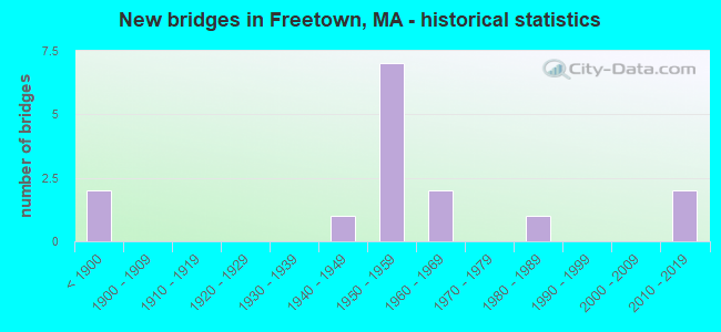
- New bridges - historical statistics
- 2Before 1900
- 11940-1949
- 71950-1959
- 21960-1969
- 11980-1989
- 22010-2019

- Reconstructed bridges - Historical Statistics
- 21960-1969
- 01970-1979
- 01980-1989
- 01990-1999
- 12000-2009
- 12010-2019


- Bridge Condition - Deck
- 9.1%Very good
- 36.4%Good
- 27.3%Satisfactory
- 27.3%Poor

- Bridge Condition - Superstructure
- 7.1%Very good
- 21.4%Good
- 50.0%Satisfactory
- 14.3%Fair
- 7.1%Poor

- Bridge Condition - Substructure
- 14.3%Very good
- 42.9%Good
- 35.7%Satisfactory
- 7.1%Fair

- Bridge Condition - Channel
- 71.4%Good
- 28.6%Satisfactory
Find on map >> Show street view
Structure Number: F090013X9DOTNBI, Location: AT JCT WASHBURN RD (Lat: 41.774544, Lng: -70.958269), Route carried "on" structure: City street , Year Built: 1941, Status: Open, Structure Length: 1.37m (4.49ft), Average Daily Traffic: 6,900 (year 2018), Truck Traffic: 6%, Average Future Daily Traffic: 15,951 (year 2031), Features Intersected: WATER FALL BROOK, Facility Carried by Structure: HWY COUNTY RD
Minimum Vertical Clearance: 30+ m (98+ ft), Kilometerpoint: 3.219, Lanes on structure: 2, Owner: State Highway Agency, Approaching Roadway Width: 14.6m (47.9ft), Material/Design: Concrete, Design/Construction: Arch - Deck, Number Of Spans In Main Unit: 1, Length of Maximum Span: 12.8m (42.0ft), Curb or Sidewalk Widths: Left: 1.5m (4.9ft), Right: 2.1m (6.9ft), Curb-To-Curb Width: 14.6m (47.9ft), Out-to-Out Width: 20.4m (66.9ft)
Condition: Deck: Satisfactory, Superstructure: Fair, Substructure: Good, Channel: Good, Operating Rating: 84.5 metric tons, Method Used To Determine Operating Rating: Load Factor (LF), Inventory Rating: 60.0 metric tons, Method Used To Determine Inventory Rating: Load Factor (LF), Structural Evaluation: Somewhat better than minimum adequacy, Deck Geometry: Superior to present desirable criteria, Waterway Adequacy: Equal to present desirable criteria, Approach Roadway Alignment: Equal to present desirable criteria, Length Of Structure Improvement: 1.40m (4.59ft), Designated Inspection Frequency: Every 24 months, Inspection Date: June 2020, Bridge Improvement Cost: $1,122,000, Roadway Improvement Cost: $113,000, Total Project Cost: $1,684,000 ( Estimate for 2022)
Find on map >> Show street view
Structure Number: F090023KPMUNNBI, Location: .9 MI NE OF RTE 24 (Lat: 41.793894, Lng: -71.067578), Route carried "on" structure: City street 79, Year Built: 1886, Status: Open, Structure Length: 1.16m (3.81ft), Average Daily Traffic: 9,450 (year 2017), Truck Traffic: 12%, Average Future Daily Traffic: 23,690 (year 2031), Design Load: H 20, Features Intersected: WATER ASSONET RIVER
Minimum Vertical Clearance: 30+ m (98+ ft), Kilometerpoint: 1.400, Lanes on structure: 2, Base Highway Network: Yes, Owner: Town or Township Highway Agency, Approaching Roadway Width: 7.0m (23.0ft), Skew: 1 degrees, Material/Design: Masonry, Design/Construction: Arch - Deck, Number Of Spans In Main Unit: 1, Length of Maximum Span: 11.6m (38.1ft), Curb or Sidewalk Widths: Left: 1.4m (4.6ft), Right: 0.0m, Curb-To-Curb Width: 7.5m (24.6ft), Out-to-Out Width: 10.0m (32.8ft)
Condition: Superstructure: Satisfactory, Substructure: Satisfactory, Channel: Satisfactory, Inventory Rating: 50.9 metric tons, Method Used To Determine Inventory Rating: Allowable Stress (AS), Structural Evaluation: Equal to present minimum criteria, Deck Geometry: High priority of replacement, Waterway Adequacy: Superior to present desirable criteria, Approach Roadway Alignment: Equal to present minimum criteria, Length Of Structure Improvement: 1.20m (3.94ft), Designated Inspection Frequency: Every 24 months, Inspection Date: October 2020, Bridge Improvement Cost: $668,000, Roadway Improvement Cost: $67,000, Total Project Cost: $1,003,000 ( Estimate for 2022)
Find on map >> Show street view
Structure Number: F090033KQMUNNBI, Location: .1 MI EAST OF ASSONET CTR (Lat: 41.795572, Lng: -71.066031), Route carried "on" structure: City street 79, Year Built: 1822, Year Reconstructed: 2010, Status: Open, Structure Length: 1.37m (4.49ft), Average Daily Traffic: 9,587 (year 2019), Truck Traffic: 5%, Average Future Daily Traffic: 14,214 (year 2031), Design Load: HS 20, Features Intersected: WATER ASSONET RIVER
Minimum Vertical Clearance: 30+ m (98+ ft), Kilometerpoint: 4.892, Lanes on structure: 2, Base Highway Network: Yes, Owner: Town or Township Highway Agency, Approaching Roadway Width: 7.1m (23.3ft), Material/Design: Masonry, Design/Construction: Arch - Deck, Number Of Spans In Main Unit: 3, Length of Maximum Span: 4.0m (13.1ft), Curb or Sidewalk Widths: Left: 0.0m, Right: 1.2m (3.9ft), Curb-To-Curb Width: 7.0m (23.0ft), Out-to-Out Width: 10.0m (32.8ft)
Condition: Superstructure: Satisfactory, Substructure: Satisfactory, Channel: Good, Operating Rating: 65.6 metric tons, Method Used To Determine Operating Rating: Load Factor (LF), Inventory Rating: 65.6 metric tons, Method Used To Determine Inventory Rating: Load Factor (LF), Structural Evaluation: Equal to present minimum criteria, Deck Geometry: High priority of replacement, Waterway Adequacy: Superior to present desirable criteria, Approach Roadway Alignment: Somewhat better than minimum adequacy, Length Of Structure Improvement: 1.40m (4.59ft), Designated Inspection Frequency: Every 24 months, Inspection Date: December 2020, Bridge Improvement Cost: $110,000, Roadway Improvement Cost: $12,000, Total Project Cost: $166,000 ( Estimate for 2022), Deck Structure Type: Concrete Cast-file-Place, Wearing Surface/Protective System: Wearing Surface: Bituminous, Membrane: Built-up, Deck Protection: Epoxy Coated Reinforcing
Find on map >> Show street view
Structure Number: F090043M6MUNNBI, Location: .01 MI N OF RTE 79 (Lat: 41.799214, Lng: -71.060047), Route carried "on" structure: City street , Year Built: 1960, Status: Open, Structure Length: 1.46m (4.79ft), Average Daily Traffic: 3,300 (year 2021), Truck Traffic: 4%, Average Future Daily Traffic: 4,896 (year 2032), Design Load: H 20, Features Intersected: WATER ASSONET RIVER, Facility Carried by Structure: HWY LOCUST ST
Minimum Vertical Clearance: 30+ m (98+ ft), Kilometerpoint: 0.000, Lanes on structure: 2, Owner: Town or Township Highway Agency, Approaching Roadway Width: 9.1m (29.9ft), Skew: 3 degrees, Material/Design: Steel, Design/Construction: Stringer/Multi-beam, Number Of Spans In Main Unit: 1, Length of Maximum Span: 11.9m (39.0ft), Curb or Sidewalk Widths: Left: 0.5m (1.6ft), Right: 0.5m (1.6ft), Curb-To-Curb Width: 8.8m (28.9ft), Out-to-Out Width: 10.8m (35.4ft)
Condition: Deck: Very good, Superstructure: Good, Substructure: Good, Channel: Good, Operating Rating: 44.4 metric tons, Method Used To Determine Operating Rating: Load Factor (LF), Inventory Rating: 26.6 metric tons, Method Used To Determine Inventory Rating: Load Factor (LF), Structural Evaluation: Equal to present minimum criteria, Deck Geometry: Meets minimum limits, Waterway Adequacy: Equal to present desirable criteria, Approach Roadway Alignment: Better than present minimum criteria, Length Of Structure Improvement: 1.50m (4.92ft), Designated Inspection Frequency: Every 24 months, Inspection Date: December 2021, Bridge Improvement Cost: $637,000, Roadway Improvement Cost: $64,000, Total Project Cost: $956,000 ( Estimate for 2022), Deck Structure Type: Concrete Cast-file-Place, Wearing Surface/Protective System: Wearing Surface: Bituminous
Find on map >> Show street view
Structure Number: F09005BDCMUNNBI, Location: @ ST 79 & RR CROSS (Lat: 41.802269, Lng: -71.052364), Route carried "on" structure: City street , Year Built: 2012, Status: Open, Structure Length: 1.03m (3.38ft), Average Daily Traffic: 600 (year 2020), Design Load: HL 93, Features Intersected: WATER ASSONET RIVER, Facility Carried by Structure: HWY FORGE RD
Minimum Vertical Clearance: 30+ m (98+ ft), Kilometerpoint: 0.048, Lanes on structure: 2, Owner: Town or Township Highway Agency, Approaching Roadway Width: 6.7m (22.0ft), Material/Design: Concrete, Design/Construction: Arch - Deck, Number Of Spans In Main Unit: 1, Length of Maximum Span: 9.7m (31.8ft), Curb-To-Curb Width: 6.7m (22.0ft), Out-to-Out Width: 9.7m (31.8ft)
Condition: Superstructure: Good, Substructure: Very good, Channel: Good, Operating Rating: 48.6 metric tons, Method Used To Determine Operating Rating: Load and Resistance Factor Rating (LRFR) rating reported by rating factor(RF) method using HL-93 loadings, Inventory Rating: 35.6 metric tons, Method Used To Determine Inventory Rating: Load and Resistance Factor Rating (LRFR) rating reported by rating factor(RF) method using HL-93 loadings, Structural Evaluation: Better than present minimum criteria, Deck Geometry: Meets minimum limits, Waterway Adequacy: Somewhat better than minimum adequacy, Approach Roadway Alignment: Meets minimum limits, Length Of Structure Improvement: 1.10m (3.61ft), Designated Inspection Frequency: Every 24 months, Inspection Date: August 2020, Bridge Improvement Cost: $571,000, Roadway Improvement Cost: $58,000, Total Project Cost: $857,000 ( Estimate for 2022)
Find on map >> Show street view
Structure Number: F09007418DOT634, Location: MP QNF 5.65 (Lat: 41.770464, Lng: -71.098828), Route carried "on" structure: City street , Year Built: 1986, Status: Open, Structure Length: 1.77m (5.81ft), Average Daily Traffic: 3,300 (year 2018), Truck Traffic: 6%, Average Future Daily Traffic: 6,317 (year 2033), Design Load: H 20, Features Intersected: RR MACRR, Facility Carried by Structure: HWY S MAIN ST
Minimum Vertical Clearance: 30+ m (98+ ft), Kilometerpoint: 0.000, Lanes on structure: 2, Owner: State Highway Agency, Approaching Roadway Width: 12.2m (40.0ft), Skew: 4 degrees, Material/Design: Steel, Design/Construction: Stringer/Multi-beam, Number Of Spans In Main Unit: 1, Length of Maximum Span: 17.1m (56.1ft), Curb or Sidewalk Widths: Left: 1.5m (4.9ft), Right: 0.2m (0.7ft), Curb-To-Curb Width: 12.2m (40.0ft), Out-to-Out Width: 14.8m (48.6ft)
Condition: Deck: Good, Superstructure: Satisfactory, Substructure: Satisfactory, Operating Rating: 75.4 metric tons, Method Used To Determine Operating Rating: Load Factor (LF), Inventory Rating: 45.2 metric tons, Method Used To Determine Inventory Rating: Load Factor (LF), Structural Evaluation: Equal to present minimum criteria, Deck Geometry: Equal to present minimum criteria, Underclear: High priority of corrective action, Approach Roadway Alignment: Superior to present desirable criteria, Length Of Structure Improvement: 1.80m (5.91ft), Designated Inspection Frequency: Every 24 months, Inspection Date: January 2022, Bridge Improvement Cost: $204,000, Roadway Improvement Cost: $21,000, Total Project Cost: $307,000 ( Estimate for 2022), Deck Structure Type: Concrete Cast-file-Place, Wearing Surface/Protective System: Wearing Surface: Bituminous, Membrane: Built-up, Deck Protection: Epoxy Coated Reinforcing
Find on map >> Show street view
Structure Number: F090083MUDOTNBI, Location: .7 MI N OF ST 79 (Lat: 41.794497, Lng: -71.077447), Route carried "on" structure: State highway 24, Year Built: 1951, Status: Open, Structure Length: 4.82m (15.81ft), Average Daily Traffic: 55,000 (year 2019), Truck Traffic: 4%, Average Future Daily Traffic: 67,752 (year 2032), Design Load: H 20, Features Intersected: WATER ASSONET RIVER
Minimum Vertical Clearance: 30+ m (98+ ft), Kilometerpoint: 18.668, Lanes on structure: 4, Base Highway Network: Yes, Owner: State Highway Agency, Approaching Roadway Width: 26.8m (87.9ft), Skew: 30 degrees, Material/Design: Steel continuous, Design/Construction: Stringer/Multi-beam, Number Of Spans In Main Unit: 3, Length of Maximum Span: 15.8m (51.8ft), Curb or Sidewalk Widths: Left: 1.0m (3.3ft), Right: 1.0m (3.3ft), Curb-To-Curb Width: 26.8m (87.9ft), Out-to-Out Width: 29.5m (96.8ft)
Condition: Deck: Poor, Superstructure: Satisfactory, Substructure: Good, Channel: Good, Operating Rating: 45.0 metric tons, Method Used To Determine Operating Rating: Load Factor (LF), Inventory Rating: 27.0 metric tons, Method Used To Determine Inventory Rating: Load Factor (LF), Structural Evaluation: Equal to present minimum criteria, Deck Geometry: Superior to present desirable criteria, Waterway Adequacy: Equal to present desirable criteria, Approach Roadway Alignment: Equal to present desirable criteria, Length Of Structure Improvement: 4.90m (16.08ft), Designated Inspection Frequency: Every 12 months, Underwater Inspection Frequency: Every 36 months, Other Special Inspection Frequency: Every 12 months, Inspection Date: August 2021, Underwater Inspection Date: Febuary 2021, Other Special Inspection Date: August 2021, Bridge Improvement Cost: $5,678,000, Roadway Improvement Cost: $568,000, Total Project Cost: $8,518,000 ( Estimate for 2022), Deck Structure Type: Concrete Cast-file-Place, Wearing Surface/Protective System: Wearing Surface: Bituminous, Membrane: Built-up
Find on map >> Show street view
Structure Number: F090103VEDOTNBI, Location: 1.0 S OF BERKLEY T.L. (Lat: 41.804147, Lng: -71.076117), Route carried "on" structure: Other road , Year Built: 1951, Status: Open, Structure Length: 5.41m (17.75ft), Average Daily Traffic: 3,150 (year 2019), Truck Traffic: 6%, Average Future Daily Traffic: 11,055 (year 2032), Design Load: H 20, Features Intersected: ST 24, Facility Carried by Structure: HWY N MAIN ST
Minimum Vertical Clearance: 30+ m (98+ ft), Kilometerpoint: 0.080, Lanes on structure: 2, Lanes under structure: 6, Owner: State Highway Agency, Approaching Roadway Width: 9.1m (29.9ft), Skew: 5 degrees, Material/Design: Steel, Design/Construction: Stringer/Multi-beam, Number Of Spans In Main Unit: 2, Length of Maximum Span: 26.2m (86.0ft), Curb or Sidewalk Widths: Left: 1.7m (5.6ft), Right: 0.6m (2.0ft), Curb-To-Curb Width: 9.1m (29.9ft), Out-to-Out Width: 12.0m (39.4ft)
Condition: Deck: Poor, Superstructure: Fair, Substructure: Satisfactory, Operating Rating: 43.7 metric tons, Method Used To Determine Operating Rating: Allowable Stress (AS), Inventory Rating: 18.2 metric tons, Method Used To Determine Inventory Rating: Allowable Stress (AS), Structural Evaluation: Somewhat better than minimum adequacy, Deck Geometry: Meets minimum limits, Underclear: Meets minimum limits, Approach Roadway Alignment: Equal to present desirable criteria, Length Of Structure Improvement: 5.50m (18.04ft), Designated Inspection Frequency: Every 12 months, Other Special Inspection Frequency: Every 12 months, Inspection Date: May 2021, Other Special Inspection Date: May 2021, Bridge Improvement Cost: $2,610,000, Roadway Improvement Cost: $262,000, Total Project Cost: $3,916,000 ( Estimate for 2022), Deck Structure Type: Concrete Cast-file-Place, Wearing Surface/Protective System: Wearing Surface: Bituminous, Membrane: Built-up
Find on map >> Show street view
Structure Number: F090113MTDOTNBI, Location: ST 24 AT ST 79 (ASSONET) (Lat: 41.785153, Lng: -71.079892), Route carried "on" structure: State highway 24, Year Built: 1951, Year Reconstructed: 2009, Status: Open, Structure Length: 2.47m (8.10ft), Average Daily Traffic: 46,745 (year 2020), Truck Traffic: 4%, Average Future Daily Traffic: 54,486 (year 2032), Design Load: H 20, Features Intersected: ST 79 S MAIN ST
Minimum Vertical Clearance: 30+ m (98+ ft), Kilometerpoint: 17.622, Lanes on structure: 6, Lanes under structure: 2, Base Highway Network: Yes, Owner: State Highway Agency, Approaching Roadway Width: 28.0m (91.9ft), Skew: 35 degrees, Material/Design: Steel, Design/Construction: Stringer/Multi-beam, Number Of Spans In Main Unit: 1, Length of Maximum Span: 23.2m (76.1ft), Curb or Sidewalk Widths: Left: 0.8m (2.6ft), Right: 0.8m (2.6ft), Curb-To-Curb Width: 23.4m (76.8ft), Out-to-Out Width: 30.8m (101.0ft)
Condition: Deck: Good, Superstructure: Good, Substructure: Good, Operating Rating: 91.8 metric tons, Method Used To Determine Operating Rating: Load Factor (LF), Inventory Rating: 55.0 metric tons, Method Used To Determine Inventory Rating: Load Factor (LF), Structural Evaluation: Better than present minimum criteria, Deck Geometry: High priority of replacement, Underclear: High priority of corrective action, Approach Roadway Alignment: Equal to present desirable criteria, Length Of Structure Improvement: 2.50m (8.20ft), Designated Inspection Frequency: Every 24 months, Inspection Date: June 2021, Bridge Improvement Cost: $1,438,000, Roadway Improvement Cost: $144,000, Total Project Cost: $2,158,000 ( Estimate for 2022), Deck Structure Type: Concrete Cast-file-Place, Wearing Surface/Protective System: Wearing Surface: Bituminous, Membrane: Built-up
Find on map >> Show street view
Structure Number: F090133X2DOTNBI, Location: AT COPICUT RD (Lat: 41.778669, Lng: -71.084217), Route carried "on" structure: Other road , Year Built: 1951, Status: Open, Structure Length: 3.23m (10.60ft), Average Daily Traffic: 642 (year 2018), Truck Traffic: 6%, Average Future Daily Traffic: 1,579 (year 2031), Design Load: H 20, Features Intersected: ST 24, Facility Carried by Structure: HWY COPICUT RD
Minimum Vertical Clearance: 30+ m (98+ ft), Kilometerpoint: 0.016, Lanes on structure: 2, Lanes under structure: 6, Owner: State Highway Agency, Approaching Roadway Width: 9.1m (29.9ft), Material/Design: Steel continuous, Design/Construction: Stringer/Multi-beam, Number Of Spans In Main Unit: 2, Length of Maximum Span: 15.5m (50.9ft), Curb or Sidewalk Widths: Left: 0.0m, Right: 1.5m (4.9ft), Curb-To-Curb Width: 9.1m (29.9ft), Out-to-Out Width: 11.6m (38.1ft)
Condition: Deck: Satisfactory, Superstructure: Satisfactory, Substructure: Good, Operating Rating: 79.5 metric tons, Method Used To Determine Operating Rating: Load Factor (LF), Inventory Rating: 47.6 metric tons, Method Used To Determine Inventory Rating: Load Factor (LF), Structural Evaluation: Equal to present minimum criteria, Deck Geometry: Equal to present minimum criteria, Underclear: Equal to present minimum criteria, Approach Roadway Alignment: Better than present minimum criteria, Length Of Structure Improvement: 3.30m (10.83ft), Designated Inspection Frequency: Every 24 months, Inspection Date: November 2020, Bridge Improvement Cost: $965,000, Roadway Improvement Cost: $97,000, Total Project Cost: $1,448,000 ( Estimate for 2022), Deck Structure Type: Concrete Cast-file-Place, Wearing Surface/Protective System: Wearing Surface: Bituminous, Membrane: Built-up
Find on map >> Show street view
Structure Number: F090173YNDOTNBI, Location: 1.2 MI S OF LAKEVIL T.L. (Lat: 41.769133, Lng: -70.961889), Route carried "on" structure: City street , Year Built: 1957, Year Reconstructed: 1968, Status: Posted for load, Structure Length: 7.44m (24.41ft), Average Daily Traffic: 10,500 (year 2018), Truck Traffic: 7%, Average Future Daily Traffic: 23,690 (year 2031), Design Load: H 20, Features Intersected: ST140, Facility Carried by Structure: HWY CHACE RD
Minimum Vertical Clearance: 30+ m (98+ ft), Kilometerpoint: 0.001, Lanes on structure: 2, Lanes under structure: 6, Owner: State Highway Agency, Approaching Roadway Width: 12.2m (40.0ft), Material/Design: Prestressed concrete, Design/Construction: Stringer/Multi-beam, Number Of Spans In Main Unit: 4, Length of Maximum Span: 23.8m (78.1ft), Curb or Sidewalk Widths: Left: 1.5m (4.9ft), Right: 0.3m (1.0ft), Curb-To-Curb Width: 12.2m (40.0ft), Out-to-Out Width: 15.1m (49.5ft)
Condition: Deck: Poor, Superstructure: Poor, Substructure: Fair, Operating Rating: 41.3 metric tons, Method Used To Determine Operating Rating: Load Factor (LF), Inventory Rating: 24.8 metric tons, Method Used To Determine Inventory Rating: Load Factor (LF), Structural Evaluation: Meets minimum limits, Deck Geometry: Somewhat better than minimum adequacy, Underclear: High priority of replacement, Approach Roadway Alignment: Equal to present desirable criteria, Length Of Structure Improvement: 8.50m (27.89ft), Designated Inspection Frequency: Every 12 months, Other Special Inspection Frequency: Every 12 months, Inspection Date: July 2020, Other Special Inspection Date: July 2021, Bridge Improvement Cost: $7,258,000, Roadway Improvement Cost: $726,000, Total Project Cost: $10,888,000 ( Estimate for 2022), Deck Structure Type: Concrete Cast-file-Place, Wearing Surface/Protective System: Wearing Surface: Epoxy Overlay
Find on map >> Show street view
Structure Number: F090183NNDOTNBI, Location: 1.0 MI S OF LAKEVIL T.L. (Lat: 41.772892, Lng: -70.962031), Route carried "on" structure: State highway 140, Year Built: 1957, Year Reconstructed: 1968, Status: Open, Structure Length: 0.65m (2.13ft), Average Daily Traffic: 33,700 (year 2017), Truck Traffic: 3%, Average Future Daily Traffic: 51,327 (year 2031), Design Load: H 20, Features Intersected: WATER FALL BROOK
Minimum Vertical Clearance: 30+ m (98+ ft), Kilometerpoint: 0.016, Lanes on structure: 5, Base Highway Network: Yes, Owner: State Highway Agency, Approaching Roadway Width: 27.1m (88.9ft), Skew: 20 degrees, Material/Design: Concrete, Design/Construction: Culvert, Number Of Spans In Main Unit: 2, Length of Maximum Span: 3.0m (9.8ft)
Condition: Channel: Satisfactory, Culverts: Satisfactory, Operating Rating: 44.1 metric tons, Method Used To Determine Operating Rating: Field evaluation and documented engineering judgment, Inventory Rating: 32.4 metric tons, Method Used To Determine Inventory Rating: Field evaluation and documented engineering judgment, Structural Evaluation: Equal to present minimum criteria, Waterway Adequacy: Better than present minimum criteria, Approach Roadway Alignment: Equal to present desirable criteria, Length Of Structure Improvement: 2.80m (9.19ft), Designated Inspection Frequency: Every 24 months, Underwater Inspection Frequency: Every 36 months, Inspection Date: November 2020, Underwater Inspection Date: March 2022, Bridge Improvement Cost: $142,000, Roadway Improvement Cost: $15,000, Total Project Cost: $214,000 ( Estimate for 2022)
Find on map >> Show street view
Structure Number: F090193NPDOTNBI, Location: .9 MI S OF LAKEVIL TL (Lat: 41.773594, Lng: -70.961856), Route carried "on" structure: State highway 140, Year Built: 1957, Status: Open, Structure Length: 3.92m (12.86ft), Average Daily Traffic: 16,241 (year 2016), Truck Traffic: 5%, Average Future Daily Traffic: 25,585 (year 2031), Design Load: H 20, Features Intersected: HWY WASHBURN RD
Minimum Vertical Clearance: 30+ m (98+ ft), Kilometerpoint: 4.023, Lanes on structure: 2, Lanes under structure: 2, Base Highway Network: Yes, Owner: State Highway Agency, Approaching Roadway Width: 13.4m (44.0ft), Skew: 1 degrees, Material/Design: Prestressed concrete, Design/Construction: Stringer/Multi-beam, Number Of Spans In Main Unit: 3, Length of Maximum Span: 16.8m (55.1ft), Curb or Sidewalk Widths: Left: 0.3m (1.0ft), Right: 0.3m (1.0ft), Curb-To-Curb Width: 13.4m (44.0ft), Out-to-Out Width: 15.0m (49.2ft)
Condition: Deck: Satisfactory, Superstructure: Satisfactory, Substructure: Satisfactory, Operating Rating: 40.1 metric tons, Method Used To Determine Operating Rating: Load Factor (LF), Inventory Rating: 24.0 metric tons, Method Used To Determine Inventory Rating: Load Factor (LF), Structural Evaluation: Somewhat better than minimum adequacy, Deck Geometry: Superior to present desirable criteria, Underclear: Somewhat better than minimum adequacy, Approach Roadway Alignment: Equal to present desirable criteria, Length Of Structure Improvement: 4.00m (13.12ft), Designated Inspection Frequency: Every 24 months, Inspection Date: November 2020, Bridge Improvement Cost: $2,357,000, Roadway Improvement Cost: $236,000, Total Project Cost: $3,536,000 ( Estimate for 2022), Deck Structure Type: Concrete Cast-file-Place, Wearing Surface/Protective System: Wearing Surface: Monolithic Concrete, Deck Protection: Epoxy Coated Reinforcing
Find on map >> Show street view
Structure Number: F090223NQDOTNBI, Location: .9 MI S OF LAKEVIL T L (Lat: 41.773533, Lng: -70.962317), Route carried "on" structure: State highway 140, Year Built: 1968, Status: Open, Structure Length: 3.63m (11.91ft), Average Daily Traffic: 16,900 (year 2017), Truck Traffic: 8%, Average Future Daily Traffic: 25,585 (year 2031), Design Load: H 20, Features Intersected: HWY WASHBURN RD
Minimum Vertical Clearance: 30+ m (98+ ft), Kilometerpoint: 16.420, Lanes on structure: 2, Lanes under structure: 2, Base Highway Network: Yes, Owner: State Highway Agency, Approaching Roadway Width: 12.2m (40.0ft), Material/Design: Prestressed concrete, Design/Construction: Stringer/Multi-beam, Number Of Spans In Main Unit: 3, Length of Maximum Span: 16.2m (53.1ft), Curb or Sidewalk Widths: Left: 0.2m (0.7ft), Right: 0.2m (0.7ft), Curb-To-Curb Width: 12.5m (41.0ft), Out-to-Out Width: 13.8m (45.3ft)
Condition: Deck: Good, Superstructure: Satisfactory, Substructure: Good, Operating Rating: 50.4 metric tons, Method Used To Determine Operating Rating: Load Factor (LF), Inventory Rating: 29.7 metric tons, Method Used To Determine Inventory Rating: Load Factor (LF), Structural Evaluation: Equal to present minimum criteria, Deck Geometry: Better than present minimum criteria, Underclear: Somewhat better than minimum adequacy, Approach Roadway Alignment: Equal to present desirable criteria, Length Of Structure Improvement: 3.70m (12.14ft), Designated Inspection Frequency: Every 24 months, Inspection Date: November 2020, Bridge Improvement Cost: $2,006,000, Roadway Improvement Cost: $201,000, Total Project Cost: $3,010,000 ( Estimate for 2022), Deck Structure Type: Concrete Cast-file-Place, Wearing Surface/Protective System: Wearing Surface: Bituminous, Membrane: Built-up
Find on map >> Show street view
Structure Number: F09023AKYDOTNBI, Location: 1.4 MILES NORTH OF EXIT 8 (Lat: 41.766806, Lng: -71.097444), Route carried "on" structure: Other road , Year Built: 2011, Status: Open, Structure Length: 5.79m (19.00ft), Average Daily Traffic: 4,700 (year 2018), Truck Traffic: 31%, Design Load: HL 93, Features Intersected: ST 24 NB & SB, Facility Carried by Structure: HWY INNOVATION W
Minimum Vertical Clearance: 30+ m (98+ ft), Kilometerpoint: 7.527, Lanes on structure: 5, Lanes under structure: 5, Owner: State Highway Agency, Approaching Roadway Width: 23.8m (78.1ft), Skew: 21 degrees, Material/Design: Steel continuous, Design/Construction: Stringer/Multi-beam, Number Of Spans In Main Unit: 2, Length of Maximum Span: 33.2m (108.9ft), Curb or Sidewalk Widths: Left: 1.6m (5.2ft), Right: 0.0m, Curb-To-Curb Width: 23.2m (76.1ft), Out-to-Out Width: 29.9m (98.1ft)
Condition: Deck: Good, Superstructure: Very good, Substructure: Very good, Operating Rating: 51.8 metric tons, Method Used To Determine Operating Rating: Load and Resistance Factor Rating (LRFR) rating reported by rating factor(RF) method using HL-93 loadings, Inventory Rating: 38.9 metric tons, Method Used To Determine Inventory Rating: Load and Resistance Factor Rating (LRFR) rating reported by rating factor(RF) method using HL-93 loadings, Structural Evaluation: Equal to present desirable criteria, Deck Geometry: Better than present minimum criteria, Underclear: Superior to present desirable criteria, Approach Roadway Alignment: Equal to present minimum criteria, Length Of Structure Improvement: 5.80m (19.03ft), Designated Inspection Frequency: Every 24 months, Inspection Date: April 2020, Bridge Improvement Cost: $1,422,000, Roadway Improvement Cost: $143,000, Total Project Cost: $2,134,000 ( Estimate for 2022), Deck Structure Type: Concrete Cast-file-Place, Wearing Surface/Protective System: Wearing Surface: Bituminous, Membrane: Preformed Fabric, Deck Protection: Epoxy Coated Reinforcing