Bridge Statistics for Fremont, Indiana (IN)
Condition, Traffic, Stress, Structural Evaluation, Project Costs
- National Bridge Inventory (NBI) Statistics
- 60Number of bridges
- 531ft / 162mTotal length
- 435,530Total average daily traffic
- 103,984Total average daily truck traffic
- National Bridge Inventory (NBI) Registered Bridges for Fremont
- No street view available for this location
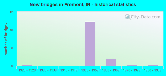
- New bridges - historical statistics
- 11920-1929
- 491950-1959
- 81960-1969
- 11970-1979
- 11980-1989
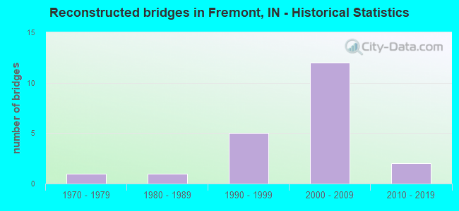
- Reconstructed bridges - Historical Statistics
- 11970-1979
- 11980-1989
- 51990-1999
- 122000-2009
- 22010-2019
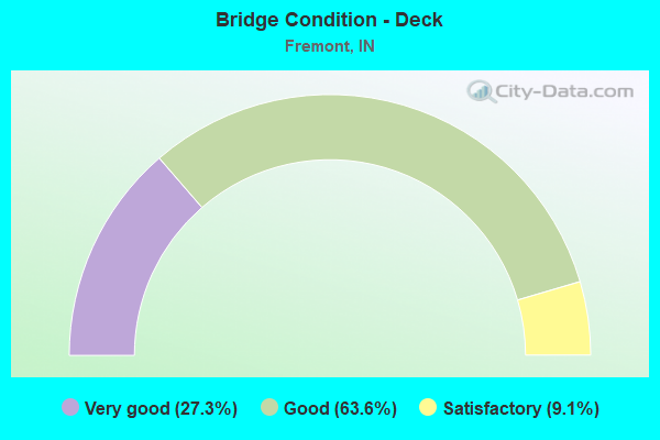
- Bridge Condition - Deck
- 27.3%Very good
- 63.6%Good
- 9.1%Satisfactory
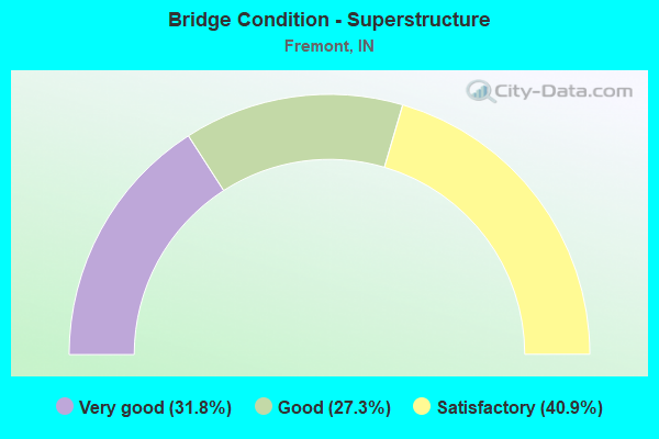
- Bridge Condition - Superstructure
- 31.8%Very good
- 27.3%Good
- 40.9%Satisfactory
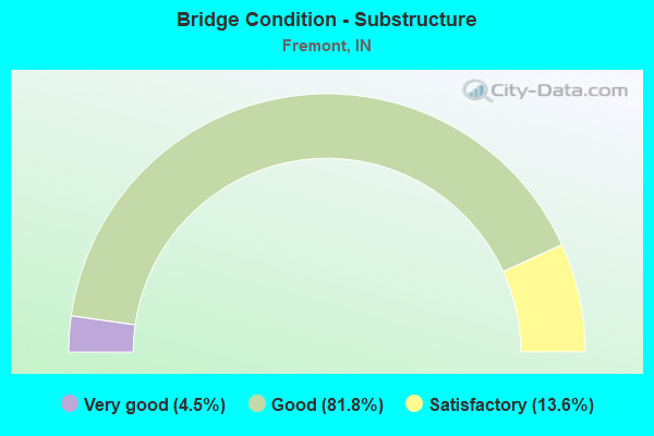
- Bridge Condition - Substructure
- 4.5%Very good
- 81.8%Good
- 13.6%Satisfactory
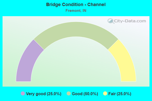
- Bridge Condition - Channel
- 25.0%Very good
- 50.0%Good
- 25.0%Fair
Find on map >> Show street view
Structure Number: 488, Location: 00.02 E SR 3 (Lat: 40.552511, Lng: -85.370619), Route carried "on" structure: State highway 18, Year Built: 1976, Year Reconstructed: 2016, Status: Open, Structure Length: 3.16m (10.37ft), Average Daily Traffic: 3,003 (year 2019), Truck Traffic: 32%, Average Future Daily Traffic: 2,990 (year 2036), Design Load: HS 20, Features Intersected: PRAIRIE CREEK
Minimum Vertical Clearance: 30+ m (98+ ft), Kilometerpoint: 6.437, Lanes on structure: 3, Owner: State Highway Agency, Approaching Roadway Width: 13.4m (44.0ft), Skew: 3 degrees, Material/Design: Concrete continuous, Design/Construction: Slab, Number Of Spans In Main Unit: 3, Length of Maximum Span: 12.5m (41.0ft), Curb-To-Curb Width: 13.4m (44.0ft), Out-to-Out Width: 14.3m (46.9ft)
Condition: Deck: Satisfactory, Superstructure: Satisfactory, Substructure: Good, Channel: Good, Operating Rating: 49.9 metric tons, Method Used To Determine Operating Rating: Load and Resistance Factor Rating (LRFR) rating reported by rating factor(RF) method using HL-93 loadings, Inventory Rating: 38.6 metric tons, Method Used To Determine Inventory Rating: Load and Resistance Factor Rating (LRFR) rating reported by rating factor(RF) method using HL-93 loadings, Structural Evaluation: Equal to present minimum criteria, Deck Geometry: Somewhat better than minimum adequacy, Waterway Adequacy: Equal to present desirable criteria, Approach Roadway Alignment: Equal to present desirable criteria, Designated Inspection Frequency: Every 24 months, Inspection Date: June 2020, Deck Structure Type: Concrete Cast-file-Place, Wearing Surface/Protective System: Wearing Surface: Latex Concrete
Find on map >> Show street view
Structure Number: 489, Location: 05.83 E SR 3 (Lat: 40.554661, Lng: -85.261469), Route carried "on" structure: State highway 18, Year Built: 1924, Year Reconstructed: 2015, Status: Open, Structure Length: 6.89m (22.60ft), Average Daily Traffic: 2,140 (year 2020), Truck Traffic: 26%, Average Future Daily Traffic: 3,670 (year 2033), Design Load: H 20, Features Intersected: SALAMONIE RIVER
Minimum Vertical Clearance: 30+ m (98+ ft), Kilometerpoint: 15.788, Lanes on structure: 2, Owner: State Highway Agency, Approaching Roadway Width: 13.4m (44.0ft), Material/Design: Concrete, Design/Construction: Arch - Deck, Number Of Spans In Main Unit: 3, Length of Maximum Span: 19.8m (65.0ft), Curb-To-Curb Width: 13.4m (44.0ft), Out-to-Out Width: 14.3m (46.9ft)
Condition: Deck: Good, Superstructure: Satisfactory, Substructure: Satisfactory, Channel: Fair, Operating Rating: 79.3 metric tons, Method Used To Determine Operating Rating: Field evaluation and documented engineering judgment, Inventory Rating: 47.3 metric tons, Method Used To Determine Inventory Rating: Field evaluation and documented engineering judgment, Structural Evaluation: Equal to present minimum criteria, Deck Geometry: Better than present minimum criteria, Waterway Adequacy: Equal to present desirable criteria, Approach Roadway Alignment: Equal to present desirable criteria, Designated Inspection Frequency: Every 24 months, Inspection Date: May 2021, Deck Structure Type: Concrete Cast-file-Place, Wearing Surface/Protective System: Wearing Surface: Latex Concrete, Deck Protection: Epoxy Coated Reinforcing
Find on map >> Show street view
Structure Number: 3302, Location: 00.19 N I-90 (Lat: 41.712831, Lng: -84.938011), Route carried "on" structure: State highway 827, Year Built: 1986, Status: Open, Structure Length: 1.54m (5.05ft), Average Daily Traffic: 5,515 (year 2016), Truck Traffic: 5%, Average Future Daily Traffic: 6,587 (year 2030), Design Load: HS 20, Features Intersected: CEMETERY LAKE DITCH
Minimum Vertical Clearance: 30+ m (98+ ft), Kilometerpoint: 8.594, Lanes on structure: 2, Owner: State Highway Agency, Approaching Roadway Width: 13.4m (44.0ft), Material/Design: Prestressed concrete, Design/Construction: Stringer/Multi-beam, Number Of Spans In Main Unit: 1, Length of Maximum Span: 14.6m (47.9ft), Curb-To-Curb Width: 13.4m (44.0ft), Out-to-Out Width: 14.2m (46.6ft)
Condition: Deck: Satisfactory, Superstructure: Very good, Substructure: Very good, Channel: Good, Operating Rating: 50.9 metric tons, Method Used To Determine Operating Rating: Load and Resistance Factor Rating (LRFR) rating reported by rating factor(RF) method using HL-93 loadings, Inventory Rating: 38.9 metric tons, Method Used To Determine Inventory Rating: Load and Resistance Factor Rating (LRFR) rating reported by rating factor(RF) method using HL-93 loadings, Structural Evaluation: Equal to present desirable criteria, Deck Geometry: Equal to present minimum criteria, Waterway Adequacy: Equal to present desirable criteria, Approach Roadway Alignment: Equal to present desirable criteria, Designated Inspection Frequency: Every 24 months, Inspection Date: April 2021, Deck Structure Type: Concrete Cast-file-Place, Wearing Surface/Protective System: Wearing Surface: Monolithic Concrete, Deck Protection: Epoxy Coated Reinforcing
Find on map >> Show street view
Structure Number: 4094, Location: 00.14 S SR 120 (Lat: 41.726889, Lng: -85.000100), Route carried "on" structure: Interstate 69, Year Built: 1966, Year Reconstructed: 2005, Status: Open, Structure Length: 37.64m (123.49ft), Average Daily Traffic: 7,832 (year 2020), Truck Traffic: 34%, Average Future Daily Traffic: 16,700 (year 2033), Design Load: HS 20+Mod, Features Intersected: GREEN LAKE
Minimum Vertical Clearance: 30+ m (98+ ft), Kilometerpoint: 571.446, Lanes on structure: 2, Base Highway Network: Yes (, Subroute: 1), Owner: State Highway Agency, Approaching Roadway Width: 11.6m (38.1ft), Material/Design: Concrete continuous, Design/Construction: Slab, Number Of Spans In Main Unit: 2, Number Of Approach Spans: 36, Length of Maximum Span: 10.2m (33.5ft), Curb-To-Curb Width: 12.9m (42.3ft), Out-to-Out Width: 13.8m (45.3ft)
Condition: Deck: Very good, Superstructure: Very good, Substructure: Good, Channel: Very good, Operating Rating: 64.2 metric tons, Method Used To Determine Operating Rating: Load Factor (LF), Inventory Rating: 37.5 metric tons, Method Used To Determine Inventory Rating: Load Factor (LF), Structural Evaluation: Better than present minimum criteria, Deck Geometry: Superior to present desirable criteria, Waterway Adequacy: Equal to present desirable criteria, Approach Roadway Alignment: Equal to present desirable criteria, Designated Inspection Frequency: Every 24 months, Underwater Inspection Frequency: Every 60 months, Inspection Date: April 2021, Underwater Inspection Date: August 2019, Deck Structure Type: Concrete Cast-file-Place, Wearing Surface/Protective System: Wearing Surface: Epoxy Overlay, Deck Protection: Epoxy Coated Reinforcing
Find on map >> Show street view
Structure Number: 4096, Location: 00.25 N SR 120 (Lat: 41.733389, Lng: -85.000314), Route carried "on" structure: Ramp Interstate 90, Year Built: 1965, Year Reconstructed: 1981, Status: Open, Structure Length: 7.16m (23.49ft), Average Daily Traffic: 3,463 (year 2011), Truck Traffic: 36%, Average Future Daily Traffic: 13,222 (year 2031), Design Load: HS 20, Features Intersected: I-69 NB/SB
Minimum Vertical Clearance: 30+ m (98+ ft), Kilometerpoint: 231.247, Lanes on structure: 2, Lanes under structure: 5, Base Highway Network: Yes (, Subroute: 1), Toll: On toll road, Owner: State Toll Authority, Approaching Roadway Width: 15.2m (49.9ft), Skew: 21 degrees, Material/Design: Steel continuous, Design/Construction: Stringer/Multi-beam, Number Of Spans In Main Unit: 2, Number Of Approach Spans: 2, Length of Maximum Span: 23.5m (77.1ft), Curb or Sidewalk Widths: Left: 0.2m (0.7ft), Right: 0.2m (0.7ft), Curb-To-Curb Width: 12.9m (42.3ft), Out-to-Out Width: 14.1m (46.3ft)
Condition: Deck: Very good, Superstructure: Very good, Substructure: Good, Operating Rating: 60.6 metric tons, Method Used To Determine Operating Rating: Load Factor (LF), Inventory Rating: 36.3 metric tons, Method Used To Determine Inventory Rating: Load Factor (LF), Structural Evaluation: Better than present minimum criteria, Deck Geometry: Superior to present desirable criteria, Underclear: Meets minimum limits, Approach Roadway Alignment: Equal to present minimum criteria, Designated Inspection Frequency: Every 24 months, Other Special Inspection Frequency: Every 24 months, Inspection Date: September 2021, Other Special Inspection Date: September 2021, Deck Structure Type: Concrete Cast-file-Place, Wearing Surface/Protective System: Wearing Surface: Latex Concrete, Deck Protection: Epoxy Coated Reinforcing
Find on map >> Show street view
Structure Number: 4097, Location: 00.88 N I-90 (Lat: 41.747531, Lng: -84.995839), Route carried "on" structure: Interstate 69, Year Built: 1964, Year Reconstructed: 2005, Status: Open, Structure Length: 3.74m (12.27ft), Average Daily Traffic: 8,943 (year 2020), Truck Traffic: 38%, Average Future Daily Traffic: 17,000 (year 2030), Design Load: HS 20, Features Intersected: LAKE GEORGE ROAD
Minimum Vertical Clearance: 30+ m (98+ ft), Kilometerpoint: 573.731, Lanes on structure: 2, Lanes under structure: 2, Base Highway Network: Yes (, Subroute: 1), Owner: State Highway Agency, Approaching Roadway Width: 13.7m (44.9ft), Material/Design: Steel continuous, Design/Construction: Stringer/Multi-beam, Number Of Spans In Main Unit: 3, Length of Maximum Span: 14.6m (47.9ft), Curb-To-Curb Width: 12.9m (42.3ft), Out-to-Out Width: 13.8m (45.3ft)
Condition: Deck: Good, Superstructure: Good, Substructure: Good, Operating Rating: 97.2 metric tons, Method Used To Determine Operating Rating: Load and Resistance Factor Rating (LRFR) rating reported by rating factor(RF) method using HL-93 loadings, Inventory Rating: 90.4 metric tons, Method Used To Determine Inventory Rating: Load and Resistance Factor Rating (LRFR) rating reported by rating factor(RF) method using HL-93 loadings, Structural Evaluation: Better than present minimum criteria, Deck Geometry: Superior to present desirable criteria, Underclear: Equal to present minimum criteria, Approach Roadway Alignment: Equal to present desirable criteria, Designated Inspection Frequency: Every 24 months, Inspection Date: March 2021, Deck Structure Type: Concrete Cast-file-Place, Wearing Surface/Protective System: Wearing Surface: Epoxy Overlay, Deck Protection: Epoxy Coated Reinforcing
Find on map >> Show street view
Structure Number: 4098, Location: 00.88 N I-90 (Lat: 41.747581, Lng: -84.996169), Route carried "on" structure: Interstate 69, Year Built: 1964, Year Reconstructed: 2005, Status: Open, Structure Length: 3.74m (12.27ft), Average Daily Traffic: 10,922 (year 2018), Truck Traffic: 21%, Average Future Daily Traffic: 19,000 (year 2030), Design Load: HS 20, Features Intersected: LAKE GEORGE ROAD
Minimum Vertical Clearance: 30+ m (98+ ft), Kilometerpoint: 573.731, Lanes on structure: 2, Lanes under structure: 2, Base Highway Network: Yes (, Subroute: 1), Owner: State Highway Agency, Approaching Roadway Width: 13.7m (44.9ft), Material/Design: Steel continuous, Design/Construction: Stringer/Multi-beam, Number Of Spans In Main Unit: 3, Length of Maximum Span: 14.6m (47.9ft), Curb-To-Curb Width: 13.8m (45.3ft), Out-to-Out Width: 13.8m (45.3ft)
Condition: Deck: Good, Superstructure: Very good, Substructure: Good, Operating Rating: 97.2 metric tons, Method Used To Determine Operating Rating: Load and Resistance Factor Rating (LRFR) rating reported by rating factor(RF) method using HL-93 loadings, Inventory Rating: 90.4 metric tons, Method Used To Determine Inventory Rating: Load and Resistance Factor Rating (LRFR) rating reported by rating factor(RF) method using HL-93 loadings, Structural Evaluation: Better than present minimum criteria, Deck Geometry: Superior to present desirable criteria, Underclear: Equal to present minimum criteria, Approach Roadway Alignment: Equal to present desirable criteria, Designated Inspection Frequency: Every 24 months, Inspection Date: March 2021, Deck Structure Type: Concrete Cast-file-Place, Wearing Surface/Protective System: Wearing Surface: Epoxy Overlay, Deck Protection: Epoxy Coated Reinforcing
Find on map >> Show street view
Structure Number: 4869, Location: 02.78 W I-69 (Lat: 41.747639, Lng: -85.048706), Route carried "on" structure: County highway , Year Built: 1956, Year Reconstructed: 2000, Status: Open, Structure Length: 6.55m (21.49ft), Average Daily Traffic: 562 (year 2014), Truck Traffic: 10%, Average Future Daily Traffic: 2,635 (year 2031), Design Load: HS 20, Features Intersected: I-90 EB/WB, Facility Carried by Structure: CR 300W
Minimum Vertical Clearance: 30+ m (98+ ft), Kilometerpoint: 226.757, Lanes on structure: 2, Lanes under structure: 4, Owner: State Toll Authority, Approaching Roadway Width: 8.5m (27.9ft), Material/Design: Steel, Design/Construction: Stringer/Multi-beam, Number Of Spans In Main Unit: 4, Length of Maximum Span: 19.8m (65.0ft), Curb-To-Curb Width: 8.2m (26.9ft), Out-to-Out Width: 9.1m (29.9ft)
Condition: Deck: Good, Superstructure: Satisfactory, Substructure: Good, Operating Rating: 83.9 metric tons, Method Used To Determine Operating Rating: Load Factor (LF), Inventory Rating: 50.2 metric tons, Method Used To Determine Inventory Rating: Load Factor (LF), Structural Evaluation: Equal to present minimum criteria, Deck Geometry: Somewhat better than minimum adequacy, Underclear: Somewhat better than minimum adequacy, Approach Roadway Alignment: Equal to present desirable criteria, Designated Inspection Frequency: Every 24 months, Other Special Inspection Frequency: Every 12 months, Inspection Date: September 2021, Other Special Inspection Date: September 2021, Deck Structure Type: Concrete Cast-file-Place, Wearing Surface/Protective System: Wearing Surface: Monolithic Concrete, Deck Protection: Epoxy Coated Reinforcing
Find on map >> Show street view
Structure Number: 487, Location: 02.02 W I-69 (Lat: 41.747711, Lng: -85.034064), Route carried "on" structure: County highway , Year Built: 1956, Year Reconstructed: 2000, Status: Open, Structure Length: 6.52m (21.39ft), Average Daily Traffic: 21 (year 2014), Truck Traffic: 10%, Average Future Daily Traffic: 196 (year 2031), Design Load: HS 20, Features Intersected: I-90 EB/WB, Facility Carried by Structure: CR 225 W/BURLING
Minimum Vertical Clearance: 30+ m (98+ ft), Kilometerpoint: 227.883, Lanes on structure: 2, Lanes under structure: 4, Owner: State Toll Authority, Approaching Roadway Width: 8.5m (27.9ft), Material/Design: Steel, Design/Construction: Stringer/Multi-beam, Number Of Spans In Main Unit: 4, Length of Maximum Span: 19.7m (64.6ft), Curb-To-Curb Width: 8.2m (26.9ft), Out-to-Out Width: 9.1m (29.9ft)
Condition: Deck: Good, Superstructure: Satisfactory, Substructure: Good, Operating Rating: 84.5 metric tons, Method Used To Determine Operating Rating: Load Factor (LF), Inventory Rating: 50.6 metric tons, Method Used To Determine Inventory Rating: Load Factor (LF), Structural Evaluation: Equal to present minimum criteria, Deck Geometry: Equal to present minimum criteria, Underclear: Somewhat better than minimum adequacy, Approach Roadway Alignment: Equal to present desirable criteria, Designated Inspection Frequency: Every 24 months, Other Special Inspection Frequency: Every 24 months, Inspection Date: September 2021, Other Special Inspection Date: September 2021, Deck Structure Type: Concrete Cast-file-Place, Wearing Surface/Protective System: Wearing Surface: Monolithic Concrete, Deck Protection: Epoxy Coated Reinforcing
Find on map >> Show street view
Structure Number: 4875, Location: 00.33 E I-69 (Lat: 41.735469, Lng: -84.993958), Route carried "on" structure: Interstate 90, Year Built: 1956, Year Reconstructed: 2005, Status: Open, Structure Length: 4.82m (15.81ft), Average Daily Traffic: 10,435 (year 2011), Truck Traffic: 14%, Average Future Daily Traffic: 25,694 (year 2031), Design Load: HS 20, Features Intersected: I-90 RAMPS 144 N/B
Minimum Vertical Clearance: 30+ m (98+ ft), Kilometerpoint: 231.778, Lanes on structure: 2, Lanes under structure: 2, Base Highway Network: Yes (, Subroute: 1), Toll: On toll road, Owner: State Toll Authority, Approaching Roadway Width: 14.0m (45.9ft), Material/Design: Steel continuous, Design/Construction: Stringer/Multi-beam, Number Of Spans In Main Unit: 3, Length of Maximum Span: 18.3m (60.0ft), Curb-To-Curb Width: 14.0m (45.9ft), Out-to-Out Width: 14.9m (48.9ft)
Condition: Deck: Good, Superstructure: Good, Substructure: Good, Operating Rating: 74.1 metric tons, Method Used To Determine Operating Rating: Load Factor (LF), Inventory Rating: 44.4 metric tons, Method Used To Determine Inventory Rating: Load Factor (LF), Structural Evaluation: Better than present minimum criteria, Deck Geometry: Superior to present desirable criteria, Underclear: Better than present minimum criteria, Approach Roadway Alignment: Equal to present desirable criteria, Designated Inspection Frequency: Every 24 months, Inspection Date: September 2021, Deck Structure Type: Concrete Cast-file-Place, Wearing Surface/Protective System: Wearing Surface: Monolithic Concrete
Find on map >> Show street view
Structure Number: 4877, Location: 00.68 W SR 120 (Lat: 41.735461, Lng: -84.981064), Route carried "on" structure: County highway , Year Built: 1956, Year Reconstructed: 1992, Status: Open, Structure Length: 6.68m (21.92ft), Average Daily Traffic: 563 (year 2014), Truck Traffic: 10%, Average Future Daily Traffic: 2,198 (year 2031), Design Load: HS 20, Features Intersected: I-90 EB/WB, Facility Carried by Structure: VAN GUILDER ROAD
Minimum Vertical Clearance: 30+ m (98+ ft), Kilometerpoint: 0.000, Lanes on structure: 2, Lanes under structure: 4, Owner: State Toll Authority, Approaching Roadway Width: 11.0m (36.1ft), Material/Design: Steel, Design/Construction: Stringer/Multi-beam, Number Of Spans In Main Unit: 4, Length of Maximum Span: 19.5m (64.0ft), Curb-To-Curb Width: 8.2m (26.9ft), Out-to-Out Width: 9.1m (29.9ft)
Condition: Deck: Good, Superstructure: Satisfactory, Substructure: Good, Operating Rating: 83.4 metric tons, Method Used To Determine Operating Rating: Load Factor (LF), Inventory Rating: 49.9 metric tons, Method Used To Determine Inventory Rating: Load Factor (LF), Structural Evaluation: Equal to present minimum criteria, Deck Geometry: Somewhat better than minimum adequacy, Underclear: Somewhat better than minimum adequacy, Approach Roadway Alignment: Equal to present minimum criteria, Designated Inspection Frequency: Every 24 months, Other Special Inspection Frequency: Every 24 months, Inspection Date: September 2021, Other Special Inspection Date: September 2021, Deck Structure Type: Concrete Cast-file-Place, Wearing Surface/Protective System: Wearing Surface: Latex Concrete, Deck Protection: Epoxy Coated Reinforcing
Find on map >> Show street view
Structure Number: 4878, Location: 01.67 E I-69 (Lat: 41.730239, Lng: -84.971047), Route carried "on" structure: Interstate 90, Year Built: 1956, Year Reconstructed: 2005, Status: Open, Structure Length: 4.82m (15.81ft), Average Daily Traffic: 9,950 (year 2011), Truck Traffic: 24%, Average Future Daily Traffic: 25,694 (year 2031), Design Load: HS 20, Features Intersected: SR 120
Minimum Vertical Clearance: 30+ m (98+ ft), Kilometerpoint: 233.934, Lanes on structure: 2, Lanes under structure: 2, Base Highway Network: Yes (, Subroute: 1), Toll: On toll road, Owner: State Toll Authority, Approaching Roadway Width: 14.0m (45.9ft), Skew: 3 degrees, Material/Design: Steel continuous, Design/Construction: Stringer/Multi-beam, Number Of Spans In Main Unit: 3, Length of Maximum Span: 16.8m (55.1ft), Curb-To-Curb Width: 14.0m (45.9ft), Out-to-Out Width: 14.9m (48.9ft)
Condition: Deck: Good, Superstructure: Very good, Substructure: Good, Operating Rating: 80.5 metric tons, Method Used To Determine Operating Rating: Load Factor (LF), Inventory Rating: 48.2 metric tons, Method Used To Determine Inventory Rating: Load Factor (LF), Structural Evaluation: Better than present minimum criteria, Deck Geometry: Superior to present desirable criteria, Underclear: Equal to present minimum criteria, Approach Roadway Alignment: Equal to present desirable criteria, Designated Inspection Frequency: Every 24 months, Inspection Date: September 2021, Deck Structure Type: Concrete Cast-file-Place, Wearing Surface/Protective System: Wearing Surface: Monolithic Concrete
Find on map >> Show street view
Structure Number: 4879, Location: 01.67 E I-69 (Lat: 41.730261, Lng: -84.970717), Route carried "on" structure: Interstate 90, Year Built: 1956, Year Reconstructed: 2005, Status: Open, Structure Length: 4.82m (15.81ft), Average Daily Traffic: 9,950 (year 2011), Truck Traffic: 24%, Average Future Daily Traffic: 25,694 (year 2031), Design Load: HS 20, Features Intersected: SR 120
Minimum Vertical Clearance: 30+ m (98+ ft), Kilometerpoint: 233.934, Lanes on structure: 2, Lanes under structure: 2, Base Highway Network: Yes (, Subroute: 1), Toll: On toll road, Owner: State Toll Authority, Approaching Roadway Width: 14.0m (45.9ft), Skew: 3 degrees, Material/Design: Steel continuous, Design/Construction: Stringer/Multi-beam, Number Of Spans In Main Unit: 3, Length of Maximum Span: 16.8m (55.1ft), Curb-To-Curb Width: 14.0m (45.9ft), Out-to-Out Width: 14.9m (48.9ft)
Condition: Deck: Very good, Superstructure: Good, Substructure: Good, Operating Rating: 80.6 metric tons, Method Used To Determine Operating Rating: Load Factor (LF), Inventory Rating: 48.2 metric tons, Method Used To Determine Inventory Rating: Load Factor (LF), Structural Evaluation: Better than present minimum criteria, Deck Geometry: Superior to present desirable criteria, Underclear: Somewhat better than minimum adequacy, Approach Roadway Alignment: Equal to present desirable criteria, Designated Inspection Frequency: Every 24 months, Inspection Date: September 2021, Deck Structure Type: Concrete Cast-file-Place, Wearing Surface/Protective System: Wearing Surface: Monolithic Concrete
Find on map >> Show street view
Structure Number: 488, Location: 00.97 W SR 827 (Lat: 41.717431, Lng: -84.956778), Route carried "on" structure: County highway , Year Built: 1956, Year Reconstructed: 2000, Status: Open, Structure Length: 7.56m (24.80ft), Average Daily Traffic: 365 (year 2004), Truck Traffic: 10%, Average Future Daily Traffic: 703 (year 2031), Design Load: HS 20, Features Intersected: I-90 EB/WB, Facility Carried by Structure: CR 500N
Minimum Vertical Clearance: 30+ m (98+ ft), Kilometerpoint: 0.000, Lanes on structure: 2, Lanes under structure: 4, Owner: State Toll Authority, Approaching Roadway Width: 8.5m (27.9ft), Skew: 22 degrees, Material/Design: Steel, Design/Construction: Stringer/Multi-beam, Number Of Spans In Main Unit: 4, Length of Maximum Span: 22.5m (73.8ft), Curb-To-Curb Width: 8.2m (26.9ft), Out-to-Out Width: 9.1m (29.9ft)
Condition: Deck: Good, Superstructure: Satisfactory, Substructure: Good, Operating Rating: 85.8 metric tons, Method Used To Determine Operating Rating: Load Factor (LF), Inventory Rating: 51.4 metric tons, Method Used To Determine Inventory Rating: Load Factor (LF), Structural Evaluation: Equal to present minimum criteria, Deck Geometry: Somewhat better than minimum adequacy, Underclear: Somewhat better than minimum adequacy, Approach Roadway Alignment: Equal to present desirable criteria, Designated Inspection Frequency: Every 24 months, Other Special Inspection Frequency: Every 24 months, Inspection Date: September 2021, Other Special Inspection Date: September 2021, Deck Structure Type: Concrete Cast-file-Place, Wearing Surface/Protective System: Wearing Surface: Monolithic Concrete, Deck Protection: Epoxy Coated Reinforcing
Find on map >> Show street view
Structure Number: 4881, Location: 00.27 W SR 827 (Lat: 41.712431, Lng: -84.944992), Route carried "on" structure: Interstate 90, Year Built: 1956, Year Reconstructed: 2004, Status: Open, Structure Length: 4.85m (15.91ft), Average Daily Traffic: 10,270 (year 2015), Truck Traffic: 45%, Average Future Daily Traffic: 25,694 (year 2031), Design Load: HS 20, Features Intersected: IN NORTHEASTERN RR CO
Minimum Vertical Clearance: 30+ m (98+ ft), Kilometerpoint: 236.928, Lanes on structure: 2, Base Highway Network: Yes (, Subroute: 1), Toll: On toll road, Owner: State Toll Authority, Approaching Roadway Width: 14.0m (45.9ft), Material/Design: Steel continuous, Design/Construction: Stringer/Multi-beam, Number Of Spans In Main Unit: 3, Number Of Approach Spans: 2, Length of Maximum Span: 12.2m (40.0ft), Curb-To-Curb Width: 14.0m (45.9ft), Out-to-Out Width: 14.9m (48.9ft)
Condition: Deck: Good, Superstructure: Very good, Substructure: Good, Operating Rating: 76.1 metric tons, Method Used To Determine Operating Rating: Load Factor (LF), Inventory Rating: 45.6 metric tons, Method Used To Determine Inventory Rating: Load Factor (LF), Structural Evaluation: Better than present minimum criteria, Deck Geometry: Superior to present desirable criteria, Underclear: Somewhat better than minimum adequacy, Approach Roadway Alignment: Equal to present desirable criteria, Designated Inspection Frequency: Every 24 months, Inspection Date: September 2021, Deck Structure Type: Concrete Cast-file-Place, Wearing Surface/Protective System: Wearing Surface: Monolithic Concrete, Deck Protection: Epoxy Coated Reinforcing
Find on map >> Show street view
Structure Number: 4882, Location: 00.27 W SR 827 (Lat: 41.712611, Lng: -84.944794), Route carried "on" structure: Interstate 90, Year Built: 1956, Year Reconstructed: 2004, Status: Open, Structure Length: 4.85m (15.91ft), Average Daily Traffic: 10,270 (year 2015), Truck Traffic: 45%, Average Future Daily Traffic: 25,694 (year 2031), Design Load: HS 20, Features Intersected: IN NORTHEASTERN RR CO
Minimum Vertical Clearance: 30+ m (98+ ft), Kilometerpoint: 236.928, Lanes on structure: 2, Base Highway Network: Yes (, Subroute: 1), Toll: On toll road, Owner: State Toll Authority, Approaching Roadway Width: 14.0m (45.9ft), Material/Design: Steel continuous, Design/Construction: Stringer/Multi-beam, Number Of Spans In Main Unit: 3, Number Of Approach Spans: 2, Length of Maximum Span: 12.2m (40.0ft), Curb-To-Curb Width: 14.0m (45.9ft), Out-to-Out Width: 14.9m (48.9ft)
Condition: Deck: Very good, Superstructure: Very good, Substructure: Good, Operating Rating: 76.1 metric tons, Method Used To Determine Operating Rating: Load Factor (LF), Inventory Rating: 45.6 metric tons, Method Used To Determine Inventory Rating: Load Factor (LF), Structural Evaluation: Better than present minimum criteria, Deck Geometry: Superior to present desirable criteria, Underclear: Somewhat better than minimum adequacy, Approach Roadway Alignment: Equal to present desirable criteria, Designated Inspection Frequency: Every 24 months, Inspection Date: September 2021, Deck Structure Type: Concrete Cast-file-Place, Wearing Surface/Protective System: Wearing Surface: Monolithic Concrete, Deck Protection: Epoxy Coated Reinforcing
Find on map >> Show street view
Structure Number: 4884, Location: 02.13 E SR 120 (Lat: 41.710689, Lng: -84.940164), Route carried "on" structure: Interstate 90, Year Built: 1956, Year Reconstructed: 2004, Status: Open, Structure Length: 4.30m (14.11ft), Average Daily Traffic: 10,270 (year 2015), Truck Traffic: 45%, Average Future Daily Traffic: 25,694 (year 2031), Design Load: HS 20, Features Intersected: SR 827
Minimum Vertical Clearance: 30+ m (98+ ft), Kilometerpoint: 237.362, Lanes on structure: 2, Lanes under structure: 2, Base Highway Network: Yes (, Subroute: 1), Toll: On toll road, Owner: State Toll Authority, Approaching Roadway Width: 14.0m (45.9ft), Skew: 1 degrees, Material/Design: Steel continuous, Design/Construction: Stringer/Multi-beam, Number Of Spans In Main Unit: 3, Number Of Approach Spans: 2, Length of Maximum Span: 14.9m (48.9ft), Curb-To-Curb Width: 14.0m (45.9ft), Out-to-Out Width: 14.9m (48.9ft)
Condition: Deck: Very good, Superstructure: Good, Substructure: Good, Operating Rating: 49.3 metric tons, Method Used To Determine Operating Rating: Load Factor (LF), Inventory Rating: 29.5 metric tons, Method Used To Determine Inventory Rating: Load Factor (LF), Structural Evaluation: Better than present minimum criteria, Deck Geometry: Superior to present desirable criteria, Underclear: Equal to present minimum criteria, Approach Roadway Alignment: Equal to present desirable criteria, Designated Inspection Frequency: Every 24 months, Inspection Date: September 2021, Deck Structure Type: Concrete Cast-file-Place, Wearing Surface/Protective System: Wearing Surface: Monolithic Concrete, Deck Protection: Epoxy Coated Reinforcing
Find on map >> Show street view
Structure Number: 4885, Location: 01.34 E SR 827 (Lat: 41.700750, Lng: -84.918067), Route carried "on" structure: County highway , Year Built: 1956, Year Reconstructed: 1999, Status: Open, Structure Length: 6.55m (21.49ft), Average Daily Traffic: 168 (year 2004), Truck Traffic: 10%, Average Future Daily Traffic: 323 (year 2031), Design Load: HS 20, Features Intersected: I-90 EB/WB, Facility Carried by Structure: CR 400N
Minimum Vertical Clearance: 30+ m (98+ ft), Kilometerpoint: 0.000, Lanes on structure: 2, Lanes under structure: 4, Owner: State Toll Authority, Approaching Roadway Width: 8.5m (27.9ft), Material/Design: Steel, Design/Construction: Stringer/Multi-beam, Number Of Spans In Main Unit: 4, Length of Maximum Span: 19.8m (65.0ft), Curb-To-Curb Width: 8.2m (26.9ft), Out-to-Out Width: 9.1m (29.9ft)
Condition: Deck: Good, Superstructure: Satisfactory, Substructure: Good, Operating Rating: 57.2 metric tons, Method Used To Determine Operating Rating: Load Factor (LF), Inventory Rating: 34.2 metric tons, Method Used To Determine Inventory Rating: Load Factor (LF), Structural Evaluation: Equal to present minimum criteria, Deck Geometry: Somewhat better than minimum adequacy, Underclear: Somewhat better than minimum adequacy, Approach Roadway Alignment: Equal to present minimum criteria, Designated Inspection Frequency: Every 24 months, Other Special Inspection Frequency: Every 24 months, Inspection Date: September 2021, Other Special Inspection Date: September 2021, Deck Structure Type: Concrete Cast-file-Place, Wearing Surface/Protective System: Wearing Surface: Monolithic Concrete, Deck Protection: Epoxy Coated Reinforcing
Find on map >> Show street view
Structure Number: 4886, Location: 02.04 E SR 827 (Lat: 41.694389, Lng: -84.907539), Route carried "on" structure: County highway , Year Built: 1956, Year Reconstructed: 1999, Status: Open, Structure Length: 7.89m (25.89ft), Average Daily Traffic: 68 (year 2014), Truck Traffic: 10%, Average Future Daily Traffic: 373 (year 2031), Design Load: HS 20, Features Intersected: I-90 EB/WB, Facility Carried by Structure: CR 450E
Minimum Vertical Clearance: 30+ m (98+ ft), Kilometerpoint: 0.000, Lanes on structure: 2, Lanes under structure: 4, Owner: State Toll Authority, Approaching Roadway Width: 8.5m (27.9ft), Skew: 3 degrees, Material/Design: Steel, Design/Construction: Stringer/Multi-beam, Number Of Spans In Main Unit: 4, Length of Maximum Span: 24.1m (79.1ft), Curb-To-Curb Width: 8.2m (26.9ft), Out-to-Out Width: 9.1m (29.9ft)
Condition: Deck: Good, Superstructure: Satisfactory, Substructure: Good, Operating Rating: 87.3 metric tons, Method Used To Determine Operating Rating: Load Factor (LF), Inventory Rating: 52.3 metric tons, Method Used To Determine Inventory Rating: Load Factor (LF), Structural Evaluation: Equal to present minimum criteria, Deck Geometry: Equal to present minimum criteria, Underclear: Somewhat better than minimum adequacy, Approach Roadway Alignment: Equal to present minimum criteria, Designated Inspection Frequency: Every 24 months, Other Special Inspection Frequency: Every 24 months, Inspection Date: September 2021, Other Special Inspection Date: September 2021, Deck Structure Type: Concrete Cast-file-Place, Wearing Surface/Protective System: Wearing Surface: Monolithic Concrete, Deck Protection: Epoxy Coated Reinforcing
Find on map >> Show street view
Structure Number: 4888, Location: 03.83 W SR 827 (Lat: 41.680958, Lng: -84.878117), Route carried "on" structure: County highway , Year Built: 1956, Year Reconstructed: 2000, Status: Open, Structure Length: 9.24m (30.31ft), Average Daily Traffic: 727 (year 2015), Truck Traffic: 10%, Average Future Daily Traffic: 1,542 (year 2031), Design Load: HS 20, Features Intersected: I-90 EB/WB, Facility Carried by Structure: CR 600E
Minimum Vertical Clearance: 30+ m (98+ ft), Kilometerpoint: 0.000, Lanes on structure: 2, Lanes under structure: 4, Owner: State Toll Authority, Approaching Roadway Width: 9.1m (29.9ft), Skew: 4 degrees, Material/Design: Steel, Design/Construction: Stringer/Multi-beam, Number Of Spans In Main Unit: 4, Length of Maximum Span: 28.4m (93.2ft), Curb-To-Curb Width: 7.9m (25.9ft), Out-to-Out Width: 9.1m (29.9ft)
Condition: Deck: Good, Superstructure: Good, Substructure: Satisfactory, Operating Rating: 93.7 metric tons, Method Used To Determine Operating Rating: Load Factor (LF), Inventory Rating: 56.1 metric tons, Method Used To Determine Inventory Rating: Load Factor (LF), Structural Evaluation: Equal to present minimum criteria, Deck Geometry: Somewhat better than minimum adequacy, Underclear: Somewhat better than minimum adequacy, Approach Roadway Alignment: Equal to present desirable criteria, Designated Inspection Frequency: Every 24 months, Other Special Inspection Frequency: Every 24 months, Inspection Date: September 2021, Other Special Inspection Date: September 2021, Deck Structure Type: Concrete Cast-file-Place, Wearing Surface/Protective System: Wearing Surface: Monolithic Concrete, Deck Protection: Epoxy Coated Reinforcing
Find on map >> Show street view
Structure Number: 4889, Location: 04.06 W US 20 (Lat: 41.673200, Lng: -84.867150), Route carried "on" structure: County highway , Year Built: 1956, Year Reconstructed: 2000, Status: Open, Structure Length: 11.19m (36.71ft), Average Daily Traffic: 380 (year 2014), Truck Traffic: 10%, Average Future Daily Traffic: 1,061 (year 2031), Design Load: HS 20, Features Intersected: I-90, Facility Carried by Structure: CR 200 N
Minimum Vertical Clearance: 30+ m (98+ ft), Kilometerpoint: 0.000, Lanes on structure: 2, Lanes under structure: 4, Owner: State Toll Authority, Approaching Roadway Width: 8.4m (27.6ft), Skew: 5 degrees, Material/Design: Steel, Design/Construction: Stringer/Multi-beam, Number Of Spans In Main Unit: 4, Length of Maximum Span: 30.8m (101.0ft), Curb-To-Curb Width: 8.2m (26.9ft), Out-to-Out Width: 9.1m (29.9ft)
Condition: Deck: Very good, Superstructure: Satisfactory, Substructure: Satisfactory, Operating Rating: 64.9 metric tons, Method Used To Determine Operating Rating: Load Factor (LF), Inventory Rating: 38.9 metric tons, Method Used To Determine Inventory Rating: Load Factor (LF), Structural Evaluation: Equal to present minimum criteria, Deck Geometry: Somewhat better than minimum adequacy, Underclear: Somewhat better than minimum adequacy, Approach Roadway Alignment: Equal to present desirable criteria, Designated Inspection Frequency: Every 24 months, Other Special Inspection Frequency: Every 24 months, Inspection Date: September 2021, Other Special Inspection Date: September 2021, Deck Structure Type: Concrete Cast-file-Place, Wearing Surface/Protective System: Wearing Surface: Monolithic Concrete, Deck Protection: Epoxy Coated Reinforcing
Find on map >> Show street view
Structure Number: 489, Location: 03.51 W US 20 (Lat: 41.668561, Lng: -84.858583), Route carried "on" structure: County highway , Year Built: 1956, Year Reconstructed: 2000, Status: Open, Structure Length: 7.80m (25.59ft), Average Daily Traffic: 100 (year 2015), Truck Traffic: 10%, Average Future Daily Traffic: 242 (year 2031), Design Load: HS 20+Mod, Features Intersected: I-90 EB/WB, Facility Carried by Structure: CR 700 E/BURCH RD
Minimum Vertical Clearance: 30+ m (98+ ft), Kilometerpoint: 0.000, Lanes on structure: 2, Lanes under structure: 4, Owner: State Toll Authority, Approaching Roadway Width: 8.4m (27.6ft), Skew: 3 degrees, Material/Design: Steel, Design/Construction: Stringer/Multi-beam, Number Of Spans In Main Unit: 4, Length of Maximum Span: 23.8m (78.1ft), Curb-To-Curb Width: 7.9m (25.9ft), Out-to-Out Width: 9.1m (29.9ft)
Condition: Deck: Good, Superstructure: Good, Substructure: Good, Operating Rating: 85.5 metric tons, Method Used To Determine Operating Rating: Load Factor (LF), Inventory Rating: 51.2 metric tons, Method Used To Determine Inventory Rating: Load Factor (LF), Structural Evaluation: Better than present minimum criteria, Deck Geometry: Equal to present minimum criteria, Underclear: Somewhat better than minimum adequacy, Approach Roadway Alignment: Equal to present desirable criteria, Designated Inspection Frequency: Every 24 months, Other Special Inspection Frequency: Every 24 months, Inspection Date: September 2021, Other Special Inspection Date: September 2021, Deck Structure Type: Concrete Cast-file-Place, Wearing Surface/Protective System: Wearing Surface: Monolithic Concrete, Deck Protection: Epoxy Coated Reinforcing
Find on map >> Show street view
Structure Number: 4096, Location: 00.25 N SR 120 (Lat: 41.733389, Lng: -85.000314), Route carried "under" structure: Interstate 69, Year Built: 1965, Structure Length: 0. m, Average Daily Traffic: 9,459 (year 2011), Truck Traffic: 33%, Features Intersected: I-69 NBL
Minimum Vertical Clearance: 4.90m (16.08ft), Kilometerpoint: 250.205, Lanes on structure: 2, Lanes under structure: 5, Toll: On toll road, Material/Design: Steel continuous, Design/Construction: Stringer/Multi-beam, Length of Maximum Span: 23.5m (77.1ft)
Find on map >> Show street view
Structure Number: 4096, Location: 00.25 N SR 120 (Lat: 41.733389, Lng: -85.000314), Route carried "under" structure: Interstate 69, Year Built: 1965, Structure Length: 0. m, Average Daily Traffic: 9,459 (year 2011), Truck Traffic: 33%, Features Intersected: I-69 SBL
Minimum Vertical Clearance: 4.90m (16.08ft), Kilometerpoint: 250.205, Lanes on structure: 2, Lanes under structure: 5, Toll: On toll road, Material/Design: Steel continuous, Design/Construction: Stringer/Multi-beam, Length of Maximum Span: 23.5m (77.1ft)
Find on map >> Show street view
Structure Number: 4097, Location: 00.88 N I-90 (Lat: 41.747539, Lng: -84.995858), Route carried "under" structure: County highway , Year Built: 1966, Structure Length: 0. m, Average Daily Traffic: 5,690 (year 2020), Truck Traffic: 52%, Features Intersected: LAKE GEORGE ROAD, Facility Carried by Structure: I-69 NB
Minimum Vertical Clearance: 4.85m (15.91ft), Kilometerpoint: 0.000, Lanes on structure: 2, Lanes under structure: 2, Material/Design: Steel continuous, Design/Construction: Stringer/Multi-beam, Length of Maximum Span: 14.6m (47.9ft)
Find on map >> Show street view
Structure Number: 4098, Location: 00.88 N I-90 (Lat: 41.747581, Lng: -84.996178), Route carried "under" structure: County highway , Year Built: 1966, Structure Length: 0. m, Average Daily Traffic: 5,690 (year 2020), Truck Traffic: 52%, Features Intersected: LAKE GEORGE ROAD, Facility Carried by Structure: I-69 SB
Minimum Vertical Clearance: 5.21m (17.09ft), Kilometerpoint: 0.000, Lanes on structure: 2, Lanes under structure: 2, Material/Design: Steel continuous, Design/Construction: Stringer/Multi-beam, Length of Maximum Span: 14.6m (47.9ft)
Find on map >> Show street view
Structure Number: 4869, Location: 02.78 W I-69 (Lat: 41.747639, Lng: -85.048706), Route carried "under" structure: Interstate 90, Year Built: 1956, Structure Length: 0. m, Average Daily Traffic: 11,010 (year 2015), Truck Traffic: 14%, Features Intersected: I-90 WB, Facility Carried by Structure: CR 300W
Minimum Vertical Clearance: 4.90m (16.08ft), Kilometerpoint: 226.773, Lanes on structure: 2, Lanes under structure: 2, Toll: On toll road, Material/Design: Steel, Design/Construction: Stringer/Multi-beam, Length of Maximum Span: 19.8m (65.0ft)
Find on map >> Show street view
Structure Number: 4869, Location: 02.78 W I-69 (Lat: 41.747639, Lng: -85.048706), Route carried "under" structure: Interstate 90, Year Built: 1956, Structure Length: 0. m, Average Daily Traffic: 11,010 (year 2015), Truck Traffic: 14%, Features Intersected: I-90 EB, Facility Carried by Structure: CR 300W
Minimum Vertical Clearance: 4.90m (16.08ft), Kilometerpoint: 226.773, Lanes on structure: 2, Lanes under structure: 2, Toll: On toll road, Material/Design: Steel, Design/Construction: Stringer/Multi-beam, Length of Maximum Span: 19.8m (65.0ft)
Find on map >> Show street view
Structure Number: 487, Location: 02.02 W I-69 (Lat: 41.747711, Lng: -85.034064), Route carried "under" structure: Interstate 90, Year Built: 1956, Structure Length: 0. m, Average Daily Traffic: 10,240 (year 2014), Truck Traffic: 14%, Features Intersected: I-90 EB, Facility Carried by Structure: CR 225W/BURLING
Minimum Vertical Clearance: 4.95m (16.24ft), Kilometerpoint: 227.996, Lanes on structure: 2, Lanes under structure: 2, Toll: On toll road, Material/Design: Steel, Design/Construction: Stringer/Multi-beam, Length of Maximum Span: 19.7m (64.6ft)
Find on map >> Show street view
Structure Number: 487, Location: 02.02 W I-69 (Lat: 41.747711, Lng: -85.034064), Route carried "under" structure: Interstate 90, Year Built: 1956, Structure Length: 0. m, Average Daily Traffic: 10,240 (year 2014), Truck Traffic: 14%, Features Intersected: I-90 WB, Facility Carried by Structure: CR 225W/BURLING
Minimum Vertical Clearance: 4.95m (16.24ft), Kilometerpoint: 227.996, Lanes on structure: 2, Lanes under structure: 2, Toll: On toll road, Material/Design: Steel, Design/Construction: Stringer/Multi-beam, Length of Maximum Span: 19.7m (64.6ft)
Find on map >> Show street view
Structure Number: 4873, Location: 01.67 W SR 120 (Lat: 41.735531, Lng: -85.000442), Route carried "under" structure: Interstate 69, Year Built: 1956, Structure Length: 0. m, Average Daily Traffic: 9,459 (year 2011), Truck Traffic: 33%, Features Intersected: I-69 SB, Facility Carried by Structure: I-90 EB
Minimum Vertical Clearance: 4.95m (16.24ft), Kilometerpoint: 250.446, Lanes on structure: 2, Lanes under structure: 6, Toll: On toll road, Material/Design: Steel, Design/Construction: Stringer/Multi-beam, Length of Maximum Span: 18.0m (59.1ft)
Find on map >> Show street view
Structure Number: 4873, Location: 01.67 W SR 120 (Lat: 41.735531, Lng: -85.000442), Route carried "under" structure: Interstate 69, Year Built: 1956, Structure Length: 0. m, Average Daily Traffic: 10,676 (year 2011), Truck Traffic: 33%, Features Intersected: I-69 NB, Facility Carried by Structure: I-90 EB
Minimum Vertical Clearance: 4.95m (16.24ft), Kilometerpoint: 250.446, Lanes on structure: 2, Lanes under structure: 6, Toll: On toll road, Material/Design: Steel, Design/Construction: Stringer/Multi-beam, Length of Maximum Span: 18.0m (59.1ft)
Find on map >> Show street view
Structure Number: 4873, Location: 01.67 W SR 120 (Lat: 41.735531, Lng: -85.000442), Route carried "under" structure: ServiceState highway 415, Year Built: 1956, Structure Length: 0. m, Average Daily Traffic: 5,000 (year 2011), Truck Traffic: 10%, Features Intersected: STEUBEN CO IR-415, Facility Carried by Structure: I-90 EB
Minimum Vertical Clearance: 4.95m (16.24ft), Kilometerpoint: 250.446, Lanes on structure: 2, Lanes under structure: 6, Toll: On toll road, Material/Design: Steel, Design/Construction: Stringer/Multi-beam, Length of Maximum Span: 18.0m (59.1ft)
Find on map >> Show street view
Structure Number: 4874, Location: 01.67 W SR 120 (Lat: 41.735761, Lng: -85.000458), Route carried "under" structure: Ramp County highway , Year Built: 1956, Structure Length: 0. m, Average Daily Traffic: 6,142 (year 2014), Truck Traffic: 15%, Features Intersected: I-90 WB, Facility Carried by Structure: STEUBEN CO IR-415
Minimum Vertical Clearance: 4.75m (15.58ft), Kilometerpoint: 250.462, Lanes on structure: 2, Lanes under structure: 2, Material/Design: Steel, Design/Construction: Stringer/Multi-beam, Length of Maximum Span: 18.0m (59.1ft)
Find on map >> Show street view
Structure Number: 4874, Location: 01.67 W SR 120 (Lat: 41.735761, Lng: -85.000458), Route carried "under" structure: Interstate 69, Year Built: 1956, Structure Length: 0. m, Average Daily Traffic: 10,510 (year 2015), Truck Traffic: 10%, Features Intersected: I-69 SB, Facility Carried by Structure: I-90 WB
Minimum Vertical Clearance: 4.75m (15.58ft), Kilometerpoint: 250.462, Lanes on structure: 2, Lanes under structure: 2, Material/Design: Steel, Design/Construction: Stringer/Multi-beam, Length of Maximum Span: 18.0m (59.1ft)
Find on map >> Show street view
Structure Number: 4874, Location: 01.67 W SR 120 (Lat: 41.735761, Lng: -85.000458), Route carried "under" structure: Interstate 69, Year Built: 1956, Structure Length: 0. m, Average Daily Traffic: 10,510 (year 2015), Truck Traffic: 10%, Features Intersected: I-69, STEUBEN CO IR-415, Facility Carried by Structure: I-90 WB
Minimum Vertical Clearance: 4.75m (15.58ft), Kilometerpoint: 250.462, Lanes on structure: 2, Lanes under structure: 2, Material/Design: Steel, Design/Construction: Stringer/Multi-beam, Length of Maximum Span: 18.0m (59.1ft)
Find on map >> Show street view
Structure Number: 4875, Location: 00.33 E I-69 (Lat: 41.735469, Lng: -84.993958), Route carried "under" structure: Ramp Interstate 90, Year Built: 1956, Structure Length: 0. m, Average Daily Traffic: 1,723 (year 2004), Truck Traffic: 10%, Features Intersected: I-90 RAMP 144B
Minimum Vertical Clearance: 5.18m (16.99ft), Kilometerpoint: 0.000, Lanes on structure: 2, Lanes under structure: 2, Toll: On toll road, Material/Design: Steel continuous, Design/Construction: Stringer/Multi-beam, Length of Maximum Span: 18.3m (60.0ft)
Find on map >> Show street view
Structure Number: 4875, Location: 00.33 E I-69 (Lat: 41.735469, Lng: -84.993958), Route carried "under" structure: Ramp Interstate 90, Year Built: 1956, Structure Length: 0. m, Average Daily Traffic: 2,184 (year 2011), Truck Traffic: 10%, Features Intersected: I-90 RAMP 144N
Minimum Vertical Clearance: 5.18m (16.99ft), Kilometerpoint: 0.000, Lanes on structure: 2, Lanes under structure: 2, Toll: On toll road, Material/Design: Steel continuous, Design/Construction: Stringer/Multi-beam, Length of Maximum Span: 18.3m (60.0ft)
Find on map >> Show street view
Structure Number: 4876, Location: 00.33 E I-69 (Lat: 41.735700, Lng: -84.993958), Route carried "under" structure: Ramp Interstate 90, Year Built: 1956, Structure Length: 0. m, Average Daily Traffic: 1,723 (year 2011), Truck Traffic: 10%, Features Intersected: I-90 RAMP 144B
Minimum Vertical Clearance: 4.98m (16.34ft), Kilometerpoint: 0.000, Lanes on structure: 2, Lanes under structure: 2, Toll: On toll road, Material/Design: Steel continuous, Design/Construction: Stringer/Multi-beam, Length of Maximum Span: 18.3m (60.0ft)
Find on map >> Show street view
Structure Number: 4876, Location: 00.33 E I-69 (Lat: 41.735700, Lng: -84.993958), Route carried "under" structure: Ramp Interstate 90, Year Built: 1956, Structure Length: 0. m, Average Daily Traffic: 2,184 (year 2011), Truck Traffic: 10%, Features Intersected: I-90 RAMP 144N
Minimum Vertical Clearance: 4.98m (16.34ft), Kilometerpoint: 0.000, Lanes on structure: 2, Lanes under structure: 2, Toll: On toll road, Material/Design: Steel continuous, Design/Construction: Stringer/Multi-beam, Length of Maximum Span: 18.3m (60.0ft)
Find on map >> Show street view
Structure Number: 4877, Location: 00.68 W SR 120 (Lat: 41.735461, Lng: -84.981064), Route carried "under" structure: Interstate 90, Year Built: 1956, Structure Length: 0. m, Average Daily Traffic: 11,010 (year 2015), Truck Traffic: 24%, Features Intersected: I-90 EB, Facility Carried by Structure: VAN GUILDER ROAD
Minimum Vertical Clearance: 4.83m (15.85ft), Kilometerpoint: 232.840, Lanes on structure: 2, Lanes under structure: 2, Toll: On toll road, Material/Design: Steel, Design/Construction: Stringer/Multi-beam, Length of Maximum Span: 19.5m (64.0ft)
Find on map >> Show street view
Structure Number: 4877, Location: 00.68 W SR 120 (Lat: 41.735461, Lng: -84.981064), Route carried "under" structure: Interstate 90, Year Built: 1956, Structure Length: 0. m, Average Daily Traffic: 11,010 (year 2015), Truck Traffic: 24%, Features Intersected: I-90 WB, Facility Carried by Structure: VAN GUILDER ROAD
Minimum Vertical Clearance: 4.83m (15.85ft), Kilometerpoint: 232.840, Lanes on structure: 2, Lanes under structure: 2, Toll: On toll road, Material/Design: Steel, Design/Construction: Stringer/Multi-beam, Length of Maximum Span: 19.5m (64.0ft)
Find on map >> Show street view
Structure Number: 4878, Location: 01.67 E I-69 (Lat: 41.730239, Lng: -84.971047), Route carried "under" structure: State highway 120, Year Built: 1956, Structure Length: 0. m, Average Daily Traffic: 5,749 (year 2014), Truck Traffic: 10%, Features Intersected: SR 120, Facility Carried by Structure: I-90 EB
Minimum Vertical Clearance: 4.60m (15.09ft), Kilometerpoint: 20.648, Lanes on structure: 2, Lanes under structure: 2, Material/Design: Steel continuous, Design/Construction: Stringer/Multi-beam, Length of Maximum Span: 16.8m (55.1ft)
Find on map >> Show street view
Structure Number: 4879, Location: 01.67 E I-69 (Lat: 41.730261, Lng: -84.970717), Route carried "under" structure: State highway 120, Year Built: 1956, Structure Length: 0. m, Average Daily Traffic: 7,109 (year 2004), Truck Traffic: 10%, Features Intersected: SR 120, Facility Carried by Structure: I-90 WB
Minimum Vertical Clearance: 4.42m (14.50ft), Kilometerpoint: 20.680, Lanes on structure: 2, Lanes under structure: 2, Toll: On toll road, Material/Design: Steel continuous, Design/Construction: Stringer/Multi-beam, Length of Maximum Span: 16.8m (55.1ft)
Find on map >> Show street view
Structure Number: 488, Location: 00.97 W SR 827 (Lat: 41.717431, Lng: -84.956778), Route carried "under" structure: Interstate 90, Year Built: 1956, Structure Length: 0. m, Average Daily Traffic: 11,010 (year 2015), Truck Traffic: 24%, Features Intersected: I-90 WB, Facility Carried by Structure: CR 500N
Minimum Vertical Clearance: 4.88m (16.01ft), Kilometerpoint: 235.801, Lanes on structure: 2, Lanes under structure: 2, Toll: On toll road, Material/Design: Steel, Design/Construction: Stringer/Multi-beam, Length of Maximum Span: 22.5m (73.8ft)
Find on map >> Show street view
Structure Number: 488, Location: 00.97 W SR 827 (Lat: 41.717431, Lng: -84.956778), Route carried "under" structure: Interstate 90, Year Built: 1956, Structure Length: 0. m, Average Daily Traffic: 11,010 (year 2015), Truck Traffic: 24%, Features Intersected: I-90 EB, Facility Carried by Structure: CR 500N
Minimum Vertical Clearance: 4.88m (16.01ft), Kilometerpoint: 235.801, Lanes on structure: 2, Lanes under structure: 2, Toll: On toll road, Material/Design: Steel, Design/Construction: Stringer/Multi-beam, Length of Maximum Span: 22.5m (73.8ft)
Find on map >> Show street view
Structure Number: 4883, Location: 02.13 E SR 120 (Lat: 41.710531, Lng: -84.940392), Route carried "under" structure: State highway 827, Year Built: 1956, Structure Length: 0. m, Average Daily Traffic: 5,353 (year 2015), Truck Traffic: 3%, Features Intersected: SR 827, Facility Carried by Structure: I-90 EB
Minimum Vertical Clearance: 4.47m (14.67ft), Kilometerpoint: 8.272, Lanes on structure: 2, Lanes under structure: 2, Material/Design: Steel continuous, Design/Construction: Stringer/Multi-beam, Length of Maximum Span: 14.9m (48.9ft)
Find on map >> Show street view
Structure Number: 4884, Location: 02.13 E SR 120 (Lat: 41.710689, Lng: -84.940164), Route carried "under" structure: State highway 827, Year Built: 1956, Structure Length: 0. m, Average Daily Traffic: 5,353 (year 2015), Truck Traffic: 3%, Features Intersected: SR 827, Facility Carried by Structure: I-90 WB
Minimum Vertical Clearance: 4.55m (14.93ft), Kilometerpoint: 8.304, Lanes on structure: 2, Lanes under structure: 2, Toll: On toll road, Material/Design: Steel continuous, Design/Construction: Stringer/Multi-beam, Length of Maximum Span: 14.9m (48.9ft)
Find on map >> Show street view
Structure Number: 4885, Location: 01.34 E SR 827 (Lat: 41.700750, Lng: -84.918067), Route carried "under" structure: Interstate 90, Year Built: 1956, Structure Length: 0. m, Average Daily Traffic: 11,010 (year 2015), Truck Traffic: 24%, Features Intersected: I-90 EB, Facility Carried by Structure: CR 400N
Minimum Vertical Clearance: 4.93m (16.17ft), Kilometerpoint: 238.714, Lanes on structure: 2, Lanes under structure: 2, Toll: On toll road, Material/Design: Steel, Design/Construction: Stringer/Multi-beam, Length of Maximum Span: 19.8m (65.0ft)
Find on map >> Show street view
Structure Number: 4885, Location: 01.34 E SR 827 (Lat: 41.700750, Lng: -84.918067), Route carried "under" structure: Interstate 90, Year Built: 1956, Structure Length: 0. m, Average Daily Traffic: 11,010 (year 2015), Truck Traffic: 24%, Features Intersected: I-90 WB, Facility Carried by Structure: CR 400N
Minimum Vertical Clearance: 4.93m (16.17ft), Kilometerpoint: 238.714, Lanes on structure: 2, Lanes under structure: 2, Toll: On toll road, Material/Design: Steel, Design/Construction: Stringer/Multi-beam, Length of Maximum Span: 19.8m (65.0ft)
Find on map >> Show street view
Structure Number: 4886, Location: 02.04 E SR 827 (Lat: 41.694389, Lng: -84.907539), Route carried "under" structure: Interstate 90, Year Built: 1956, Structure Length: 0. m, Average Daily Traffic: 11,010 (year 2015), Truck Traffic: 24%, Features Intersected: I-90 EB, Facility Carried by Structure: CR 450E
Minimum Vertical Clearance: 4.90m (16.08ft), Kilometerpoint: 240.645, Lanes on structure: 2, Lanes under structure: 2, Toll: On toll road, Material/Design: Steel, Design/Construction: Stringer/Multi-beam, Length of Maximum Span: 24.1m (79.1ft)
Find on map >> Show street view
Structure Number: 4886, Location: 02.04 E SR 827 (Lat: 41.694389, Lng: -84.907539), Route carried "under" structure: Interstate 90, Year Built: 1956, Structure Length: 0. m, Average Daily Traffic: 11,010 (year 2015), Truck Traffic: 24%, Features Intersected: I-90 WB, Facility Carried by Structure: CR 450E
Minimum Vertical Clearance: 4.90m (16.08ft), Kilometerpoint: 240.645, Lanes on structure: 2, Lanes under structure: 2, Toll: On toll road, Material/Design: Steel, Design/Construction: Stringer/Multi-beam, Length of Maximum Span: 24.1m (79.1ft)
Find on map >> Show street view
Structure Number: 4887, Location: 03.18 W SR 827 (Lat: 41.686869, Lng: -84.887833), Route carried "under" structure: Interstate 90, Year Built: 1956, Structure Length: 0. m, Average Daily Traffic: 11,010 (year 2015), Truck Traffic: 24%, Features Intersected: I-90 WB, Facility Carried by Structure: CR 550E
Minimum Vertical Clearance: 4.88m (16.01ft), Kilometerpoint: 242.480, Lanes on structure: 2, Lanes under structure: 2, Toll: On toll road, Material/Design: Steel, Design/Construction: Stringer/Multi-beam, Length of Maximum Span: 23.5m (77.1ft)
Find on map >> Show street view
Structure Number: 4887, Location: 03.18 W SR 827 (Lat: 41.686869, Lng: -84.887833), Route carried "under" structure: Interstate 90, Year Built: 1956, Structure Length: 0. m, Average Daily Traffic: 11,010 (year 2011), Truck Traffic: 24%, Features Intersected: I-90 EB, Facility Carried by Structure: CR 550E
Minimum Vertical Clearance: 4.88m (16.01ft), Kilometerpoint: 242.480, Lanes on structure: 2, Lanes under structure: 2, Toll: On toll road, Material/Design: Steel, Design/Construction: Stringer/Multi-beam, Length of Maximum Span: 23.5m (77.1ft)
Find on map >> Show street view
Structure Number: 4888, Location: 03.83 W SR 827 (Lat: 41.680950, Lng: -84.878136), Route carried "under" structure: Interstate 90, Year Built: 1956, Structure Length: 0. m, Average Daily Traffic: 11,010 (year 2015), Truck Traffic: 24%, Features Intersected: I-90 EB, Facility Carried by Structure: CR 600E
Minimum Vertical Clearance: 4.93m (16.17ft), Kilometerpoint: 243.526, Lanes on structure: 2, Lanes under structure: 2, Toll: On toll road, Material/Design: Steel, Design/Construction: Stringer/Multi-beam, Length of Maximum Span: 28.4m (93.2ft)
Find on map >> Show street view
Structure Number: 4888, Location: 03.83 W SR 827 (Lat: 41.680950, Lng: -84.878136), Route carried "under" structure: Interstate 90, Year Built: 1956, Structure Length: 0. m, Average Daily Traffic: 11,010 (year 2015), Truck Traffic: 24%, Features Intersected: I-90 WB, Facility Carried by Structure: CR 600E
Minimum Vertical Clearance: 4.93m (16.17ft), Kilometerpoint: 243.526, Lanes on structure: 2, Lanes under structure: 2, Toll: On toll road, Material/Design: Steel, Design/Construction: Stringer/Multi-beam, Length of Maximum Span: 28.4m (93.2ft)
Find on map >> Show street view
Structure Number: 4889, Location: 04.06 W US 20 (Lat: 41.673200, Lng: -84.867150), Route carried "under" structure: Interstate 90, Year Built: 1956, Structure Length: 0. m, Average Daily Traffic: 10,270 (year 2015), Truck Traffic: 24%, Features Intersected: I-90 WB, Facility Carried by Structure: CR 200N
Minimum Vertical Clearance: 5.01m (16.44ft), Kilometerpoint: 244.781, Lanes on structure: 2, Lanes under structure: 2, Toll: On toll road, Material/Design: Steel, Design/Construction: Stringer/Multi-beam, Length of Maximum Span: 30.8m (101.0ft)
Find on map >> Show street view
Structure Number: 4889, Location: 04.06 W US 20 (Lat: 41.673200, Lng: -84.867150), Route carried "under" structure: Interstate 90, Year Built: 1956, Structure Length: 0. m, Average Daily Traffic: 10,270 (year 2015), Truck Traffic: 24%, Features Intersected: I-90, Facility Carried by Structure: CR 200 N
Minimum Vertical Clearance: 5.01m (16.44ft), Kilometerpoint: 244.781, Lanes on structure: 2, Lanes under structure: 2, Toll: On toll road, Material/Design: Steel, Design/Construction: Stringer/Multi-beam, Length of Maximum Span: 30.8m (101.0ft)
Find on map >> Show street view
Structure Number: 489, Location: 03.51 W US 20 (Lat: 41.668561, Lng: -84.858583), Route carried "under" structure: Interstate 90, Year Built: 1956, Structure Length: 0. m, Average Daily Traffic: 10,240 (year 2015), Truck Traffic: 24%, Features Intersected: I-90 EB/WB, Facility Carried by Structure: CR 700 E/BURCH RD
Minimum Vertical Clearance: 4.93m (16.17ft), Kilometerpoint: 245.666, Lanes on structure: 2, Lanes under structure: 2, Toll: On toll road, Material/Design: Steel, Design/Construction: Stringer/Multi-beam, Length of Maximum Span: 23.8m (78.1ft)
Find on map >> Show street view
Structure Number: 489, Location: 03.51 W US 20 (Lat: 41.668561, Lng: -84.858583), Route carried "under" structure: Interstate 90, Year Built: 1956, Structure Length: 0. m, Average Daily Traffic: 10,240 (year 2015), Truck Traffic: 24%, Features Intersected: I-90 WB, Facility Carried by Structure: CR 700E/BURCH RD
Minimum Vertical Clearance: 4.93m (16.17ft), Kilometerpoint: 245.666, Lanes on structure: 2, Lanes under structure: 2, Toll: On toll road, Material/Design: Steel, Design/Construction: Stringer/Multi-beam, Length of Maximum Span: 23.8m (78.1ft)