Bridge Statistics for Funkstown, Maryland (MD)
Condition, Traffic, Stress, Structural Evaluation, Project Costs
- National Bridge Inventory (NBI) Statistics
- 12Number of bridges
- 108ft / 32.6mTotal length
- $1,350,000Total costs
- 155,411Total average daily traffic
- 10,908Total average daily truck traffic
- National Bridge Inventory (NBI) Registered Bridges for Funkstown
- No street view available for this location
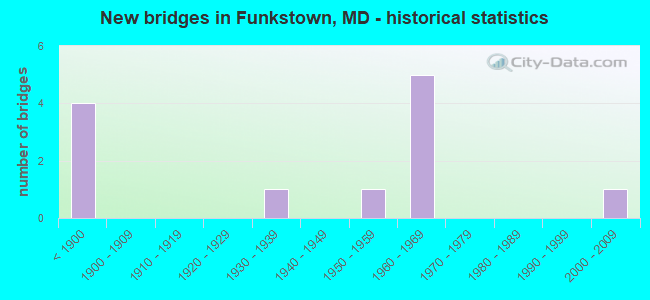
- New bridges - historical statistics
- 4Before 1900
- 11930-1939
- 11950-1959
- 51960-1969
- 12000-2009

- Reconstructed bridges - Historical Statistics
- 21980-1989
- 01990-1999
- 12000-2009
- 32010-2019


- Bridge Condition - Deck
- 20.0%Good
- 80.0%Fair

- Bridge Condition - Superstructure
- 50.0%Good
- 37.5%Satisfactory
- 12.5%Fair

- Bridge Condition - Substructure
- 12.5%Very good
- 37.5%Good
- 25.0%Satisfactory
- 25.0%Fair

- Bridge Condition - Channel
- 37.5%Good
- 62.5%Satisfactory

- Bridge Condition - Culverts
- 50.0%Good
- 50.0%Satisfactory
Find on map >> Show street view
Structure Number: 100000210121013, Location: 1.07 MILES WEST OF US 40 (Lat: 39.599581, Lng: -77.702672), Route carried "on" structure: Interstate 70, Year Built: 1965, Status: Open, Structure Length: 5.61m (18.41ft), Average Daily Traffic: 62,740 (year 2009), Truck Traffic: 8%, Average Future Daily Traffic: 42,488 (year 2026), Design Load: HS 20, Features Intersected: US 40 ALT
Minimum Vertical Clearance: 30+ m (98+ ft), Kilometerpoint: 49.227, Lanes on structure: 2, Lanes under structure: 4, Base Highway Network: Yes, Owner: State Highway Agency, Approaching Roadway Width: 11.6m (38.1ft), Skew: 3 degrees, Material/Design: Steel, Design/Construction: Stringer/Multi-beam, Number Of Spans In Main Unit: 3, Length of Maximum Span: 27.4m (89.9ft), Curb-To-Curb Width: 12.2m (40.0ft), Out-to-Out Width: 12.8m (42.0ft)
Condition: Deck: Fair, Superstructure: Satisfactory, Substructure: Fair, Inventory Rating: 69.8 metric tons, Method Used To Determine Inventory Rating: Load Factor (LF), Structural Evaluation: Somewhat better than minimum adequacy, Deck Geometry: Better than present minimum criteria, Underclear: Somewhat better than minimum adequacy, Approach Roadway Alignment: Equal to present desirable criteria, Designated Inspection Frequency: Every 24 months, Inspection Date: November 2021, Deck Structure Type: Concrete Cast-file-Place, Wearing Surface/Protective System: Wearing Surface: Bituminous
Find on map >> Show street view
Structure Number: 100000210121014, Location: 1.07 MILES WEST OF US 40 (Lat: 39.599789, Lng: -77.702211), Route carried "on" structure: Interstate 70, Year Built: 1965, Status: Open, Structure Length: 5.61m (18.41ft), Average Daily Traffic: 62,740 (year 2009), Truck Traffic: 8%, Average Future Daily Traffic: 42,488 (year 2026), Design Load: HS 20, Features Intersected: US 40 ALT
Minimum Vertical Clearance: 30+ m (98+ ft), Kilometerpoint: 49.227, Lanes on structure: 2, Lanes under structure: 4, Base Highway Network: Yes, Owner: State Highway Agency, Approaching Roadway Width: 11.6m (38.1ft), Skew: 3 degrees, Material/Design: Steel, Design/Construction: Stringer/Multi-beam, Number Of Spans In Main Unit: 3, Length of Maximum Span: 27.4m (89.9ft), Curb-To-Curb Width: 12.2m (40.0ft), Out-to-Out Width: 12.8m (42.0ft)
Condition: Deck: Fair, Superstructure: Satisfactory, Substructure: Fair, Inventory Rating: 69.8 metric tons, Method Used To Determine Inventory Rating: Load Factor (LF), Structural Evaluation: Somewhat better than minimum adequacy, Deck Geometry: Better than present minimum criteria, Underclear: Somewhat better than minimum adequacy, Approach Roadway Alignment: Equal to present desirable criteria, Designated Inspection Frequency: Every 24 months, Inspection Date: November 2021, Deck Structure Type: Concrete Cast-file-Place, Wearing Surface/Protective System: Wearing Surface: Bituminous
Find on map >> Show street view
Structure Number: 200000W-001101, Location: 0.3 MI N OF IS 68 (Lat: 40.190694, Lng: -78.553936), Route carried "on" structure: County highway 1, Year Built: 1961, Year Reconstructed: 1988, Status: Posted for load, Structure Length: 3.81m (12.50ft), Average Daily Traffic: 153 (year 2019), Truck Traffic: 5%, Average Future Daily Traffic: 373 (year 2039), Design Load: H 15, Features Intersected: SIDELING HILL CREEK, Facility Carried by Structure: HIGH GERMANY ROAD
Minimum Vertical Clearance: 30+ m (98+ ft), Kilometerpoint: 0.000, Lanes on structure: 2, Owner: County Highway Agency, Approaching Roadway Width: 9.8m (32.2ft), Skew: 1 degrees, Material/Design: Prestressed concrete, Design/Construction: Stringer/Multi-beam, Number Of Spans In Main Unit: 2, Length of Maximum Span: 17.4m (57.1ft), Curb-To-Curb Width: 6.7m (22.0ft), Out-to-Out Width: 8.2m (26.9ft)
Condition: Deck: Fair, Superstructure: Satisfactory, Substructure: Satisfactory, Channel: Good, Operating Rating: 40.4 metric tons, Method Used To Determine Operating Rating: Load Factor (LF), Inventory Rating: 24.0 metric tons, Method Used To Determine Inventory Rating: Load Factor (LF), Structural Evaluation: Equal to present minimum criteria, Deck Geometry: Meets minimum limits, Waterway Adequacy: Equal to present desirable criteria, Approach Roadway Alignment: Equal to present minimum criteria, Designated Inspection Frequency: Every 24 months, Underwater Inspection Frequency: Every 48 months, Inspection Date: November 2021, Underwater Inspection Date: November 2019, Bridge Improvement Cost: $37,000, Deck Structure Type: Concrete Cast-file-Place, Wearing Surface/Protective System: Wearing Surface: Bituminous
Find on map >> Show street view
Structure Number: 200000W-341102, Location: JCT. LONDONTOWNE DR (Lat: 39.605294, Lng: -77.674011), Route carried "on" structure: County highway 341, Year Built: 2001, Status: Open, Structure Length: 0.85m (2.79ft), Average Daily Traffic: 423 (year 2015), Truck Traffic: 2%, Average Future Daily Traffic: 583 (year 2037), Design Load: H 20, Features Intersected: TRIB. OF LANDIS SPRING, Facility Carried by Structure: LANDIS ROAD
Minimum Vertical Clearance: 30+ m (98+ ft), Kilometerpoint: 0.000, Lanes on structure: 2, Owner: County Highway Agency, Approaching Roadway Width: 6.7m (22.0ft), Skew: 1 degrees, Material/Design: Concrete, Design/Construction: Culvert, Number Of Spans In Main Unit: 3, Length of Maximum Span: 2.4m (7.9ft), Curb-To-Curb Width: 12.2m (40.0ft), Out-to-Out Width: 12.8m (42.0ft)
Condition: Channel: Good, Culverts: Good, Operating Rating: 68.0 metric tons, Method Used To Determine Operating Rating: Load Factor (LF), Inventory Rating: 40.8 metric tons, Method Used To Determine Inventory Rating: Load Factor (LF), Structural Evaluation: Better than present minimum criteria, Deck Geometry: Equal to present desirable criteria, Waterway Adequacy: Better than present minimum criteria, Approach Roadway Alignment: Equal to present desirable criteria, Designated Inspection Frequency: Every 24 months, Inspection Date: November 2021, Wearing Surface/Protective System: Wearing Surface: Bituminous
Find on map >> Show street view
Structure Number: 200000W-342101, Location: 0.5 MI W OF MD 66,IS 70IN (Lat: 39.584978, Lng: -77.646400), Route carried "on" structure: County highway 344, Year Built: 1930, Year Reconstructed: 1985, Status: Posted for load, Structure Length: 4.37m (14.34ft), Average Daily Traffic: 153 (year 2017), Truck Traffic: 5%, Average Future Daily Traffic: 211 (year 2037), Design Load: H 15, Features Intersected: BEAVER CREEK, Facility Carried by Structure: BEAVER CREEK CHURC
Minimum Vertical Clearance: 30+ m (98+ ft), Kilometerpoint: 1.142, Lanes on structure: 1, Owner: County Highway Agency, Approaching Roadway Width: 4.3m (14.1ft), Material/Design: Steel, Design/Construction: Stringer/Multi-beam, Number Of Spans In Main Unit: 4, Length of Maximum Span: 10.7m (35.1ft), Curb-To-Curb Width: 4.3m (14.1ft), Out-to-Out Width: 4.7m (15.4ft)
Condition: Deck: Fair, Superstructure: Fair, Substructure: Satisfactory, Channel: Good, Operating Rating: 25.4 metric tons, Method Used To Determine Operating Rating: Load Factor (LF), Inventory Rating: 18.6 metric tons, Method Used To Determine Inventory Rating: Load Factor (LF), Structural Evaluation: Somewhat better than minimum adequacy, Deck Geometry: High priority of replacement, Waterway Adequacy: Equal to present desirable criteria, Approach Roadway Alignment: High priority of corrective action, Bridge Posting: Required (Relationship of Operating Rating to Maximum Legal Load: 20.0 - 29.9% below), Designated Inspection Frequency: Every 24 months, Inspection Date: October 2021, Deck Structure Type: Wood or Timber, Wearing Surface/Protective System: Wearing Surface: Wood or Timber
Find on map >> Show street view
Structure Number: 200000W-400101, Location: 0.09 MI W OF ALT US RT 40 (Lat: 0.660117, Lng: -1.295117), Route carried "on" structure: County highway 400, Year Built: 1833, Year Reconstructed: 2008, Status: Posted for load, Structure Length: 3.32m (10.89ft), Average Daily Traffic: 10,938 (year 2015), Truck Traffic: 5%, Average Future Daily Traffic: 15,079 (year 2037), Design Load: HS 20, Features Intersected: ANTIETAM CREEK, Facility Carried by Structure: EAST OAK RIDGE DRI
Minimum Vertical Clearance: 30+ m (98+ ft), Kilometerpoint: 0.161, Lanes on structure: 1, Owner: County Highway Agency, Approaching Roadway Width: 7.3m (24.0ft), Material/Design: Masonry, Design/Construction: Arch - Deck, Number Of Spans In Main Unit: 3, Length of Maximum Span: 10.7m (35.1ft), Curb-To-Curb Width: 5.1m (16.7ft), Out-to-Out Width: 6.1m (20.0ft)
Condition: Superstructure: Good, Substructure: Good, Channel: Satisfactory, Inventory Rating: 85.1 metric tons, Method Used To Determine Inventory Rating: Load Factor (LF), Structural Evaluation: Better than present minimum criteria, Deck Geometry: High priority of replacement, Waterway Adequacy: Equal to present desirable criteria, Approach Roadway Alignment: High priority of corrective action, Length Of Structure Improvement: 3.32m (10.89ft), Designated Inspection Frequency: Every 24 months, Inspection Date: November 2021, Bridge Improvement Cost: $350,000, Roadway Improvement Cost: $10,000, Total Project Cost: $360,000, Wearing Surface/Protective System: Wearing Surface: Bituminous
Find on map >> Show street view
Structure Number: 200000W-401101, Location: 0.57 MI W OF ALT US RT 40 (Lat: 39.595111, Lng: -77.710417), Route carried "on" structure: County highway 401, Year Built: 1841, Year Reconstructed: 2019, Status: Open, Structure Length: 0.61m (2.00ft), Average Daily Traffic: 1,698 (year 2015), Truck Traffic: 5%, Average Future Daily Traffic: 2,340 (year 2037), Design Load: HS 20, Features Intersected: ANTIETAM CREEK, Facility Carried by Structure: POFFENBERGER ROAD
Minimum Vertical Clearance: 30+ m (98+ ft), Kilometerpoint: 1.802, Lanes on structure: 1, Owner: County Highway Agency, Approaching Roadway Width: 7.6m (24.9ft), Material/Design: Masonry, Design/Construction: Arch - Deck, Number Of Spans In Main Unit: 1, Length of Maximum Span: 6.1m (20.0ft), Curb-To-Curb Width: 4.9m (16.1ft), Out-to-Out Width: 6.1m (20.0ft)
Condition: Superstructure: Good, Substructure: Good, Channel: Satisfactory, Structural Evaluation: Better than present minimum criteria, Deck Geometry: High priority of replacement, Waterway Adequacy: Better than present minimum criteria, Approach Roadway Alignment: High priority of corrective action, Length Of Structure Improvement: 0.91m (2.99ft), Designated Inspection Frequency: Every 24 months, Inspection Date: October 2021, Bridge Improvement Cost: $170,000, Roadway Improvement Cost: $30,000, Total Project Cost: $200,000, Wearing Surface/Protective System: Wearing Surface: Bituminous
Find on map >> Show street view
Structure Number: 200000W-401201, Location: 0.54 MI W OF ALT US RT 40 (Lat: 39.595058, Lng: -77.710119), Route carried "on" structure: County highway 401, Year Built: 1840, Year Reconstructed: 2019, Status: Open, Structure Length: 3.66m (12.01ft), Average Daily Traffic: 1,698 (year 2015), Truck Traffic: 5%, Average Future Daily Traffic: 2,340 (year 2037), Design Load: HS 20, Features Intersected: ANTIETAM CREEK, Facility Carried by Structure: POFFENBERGER ROAD
Minimum Vertical Clearance: 30+ m (98+ ft), Kilometerpoint: 1.850, Lanes on structure: 1, Owner: County Highway Agency, Approaching Roadway Width: 6.4m (21.0ft), Material/Design: Masonry, Design/Construction: Arch - Deck, Number Of Spans In Main Unit: 3, Length of Maximum Span: 11.6m (38.1ft), Curb-To-Curb Width: 4.9m (16.1ft), Out-to-Out Width: 6.1m (20.0ft)
Condition: Superstructure: Good, Substructure: Very good, Channel: Satisfactory, Structural Evaluation: Better than present minimum criteria, Deck Geometry: High priority of replacement, Waterway Adequacy: Better than present minimum criteria, Approach Roadway Alignment: High priority of corrective action, Length Of Structure Improvement: 3.96m (12.99ft), Designated Inspection Frequency: Every 24 months, Inspection Date: November 2021, Bridge Improvement Cost: $750,000, Roadway Improvement Cost: $40,000, Total Project Cost: $790,000, Wearing Surface/Protective System: Wearing Surface: Bituminous
Find on map >> Show street view
Structure Number: 200000W-402101, Location: 0.64 M SW OF ALT US RT 40 (Lat: 39.588244, Lng: -77.707069), Route carried "on" structure: County highway 788, Year Built: 1839, Year Reconstructed: 2017, Status: Open, Structure Length: 4.02m (13.19ft), Average Daily Traffic: 1,698 (year 2020), Truck Traffic: 5%, Average Future Daily Traffic: 2,235 (year 2040), Design Load: HS 20, Features Intersected: ANTIETAM CREEK, Facility Carried by Structure: GARIS SHOP ROAD
Minimum Vertical Clearance: 30+ m (98+ ft), Kilometerpoint: 4.199, Lanes on structure: 1, Owner: County Highway Agency, Approaching Roadway Width: 6.7m (22.0ft), Material/Design: Masonry, Design/Construction: Arch - Deck, Number Of Spans In Main Unit: 3, Length of Maximum Span: 11.3m (37.1ft), Curb-To-Curb Width: 5.0m (16.4ft), Out-to-Out Width: 5.9m (19.4ft)
Condition: Deck: Good, Superstructure: Good, Substructure: Good, Channel: Satisfactory, Inventory Rating: 84.4 metric tons, Method Used To Determine Inventory Rating: Load Factor (LF), Structural Evaluation: Better than present minimum criteria, Deck Geometry: High priority of replacement, Waterway Adequacy: Equal to present desirable criteria, Approach Roadway Alignment: Better than present minimum criteria, Designated Inspection Frequency: Every 24 months, Underwater Inspection Frequency: Every 48 months, Inspection Date: January 2020, Underwater Inspection Date: January 2020, Wearing Surface/Protective System: Wearing Surface: Bituminous
Find on map >> Show street view
Structure Number: 200000W-562103, Location: 1.0 MI NE OF MD RTE 68 (Lat: 39.575911, Lng: -77.754214), Route carried "on" structure: County highway 562, Year Built: 1950, Status: Open, Structure Length: 0.70m (2.30ft), Average Daily Traffic: 1,006 (year 2015), Truck Traffic: 5%, Average Future Daily Traffic: 1,387 (year 2037), Features Intersected: SAINT JAMES RUN, Facility Carried by Structure: COLLEGE ROAD
Minimum Vertical Clearance: 30+ m (98+ ft), Kilometerpoint: 2.510, Lanes on structure: 2, Owner: County Highway Agency, Approaching Roadway Width: 9.8m (32.2ft), Material/Design: Concrete, Design/Construction: Culvert, Number Of Spans In Main Unit: 3, Length of Maximum Span: 1.5m (4.9ft)
Condition: Channel: Satisfactory, Culverts: Satisfactory, Inventory Rating: 79.8 metric tons, Method Used To Determine Inventory Rating: Load Factor (LF), Structural Evaluation: Equal to present minimum criteria, Waterway Adequacy: Better than present minimum criteria, Approach Roadway Alignment: Equal to present desirable criteria, Designated Inspection Frequency: Every 24 months, Inspection Date: October 2021, Wearing Surface/Protective System: Wearing Surface: Bituminous
Find on map >> Show street view
Structure Number: 100000210121013, Location: 2.09 M W OF BR NO 2101900 (Lat: 39.599581, Lng: -77.702672), Route carried "under" structure: Alternate US 40, Year Built: 1965, Structure Length: 0. m, Average Daily Traffic: 6,082 (year 2009), Features Intersected: US 40 ALT, Facility Carried by Structure: IS 70 EBR
Minimum Vertical Clearance: 4.57m (14.99ft), Kilometerpoint: 5.052, Lanes on structure: 2, Lanes under structure: 4, Material/Design: Steel, Design/Construction: Stringer/Multi-beam, Length of Maximum Span: 27.4m (89.9ft)
Find on map >> Show street view
Structure Number: 100000210121014, Location: 2.09 M W OF BR NO 2101900 (Lat: 39.599789, Lng: -77.702211), Route carried "under" structure: Alternate US 40, Year Built: 1965, Structure Length: 0. m, Average Daily Traffic: 6,082 (year 2009), Features Intersected: US 40 ALT, Facility Carried by Structure: IS 70 WBR
Minimum Vertical Clearance: 4.57m (14.99ft), Kilometerpoint: 5.052, Lanes on structure: 2, Lanes under structure: 4, Material/Design: Steel, Design/Construction: Stringer/Multi-beam, Length of Maximum Span: 27.4m (89.9ft)