Bridge Statistics for Garretson, South Dakota (SD)
Condition, Traffic, Stress, Structural Evaluation, Project Costs
- National Bridge Inventory (NBI) Statistics
- 21Number of bridges
- 220ft / 67.0mTotal length
- $9,152,000Total costs
- 24,134Total average daily traffic
- 1,563Total average daily truck traffic
- 36,624Total future (year 2032) average daily traffic
- National Bridge Inventory (NBI) Registered Bridges for Garretson
- No street view available for this location
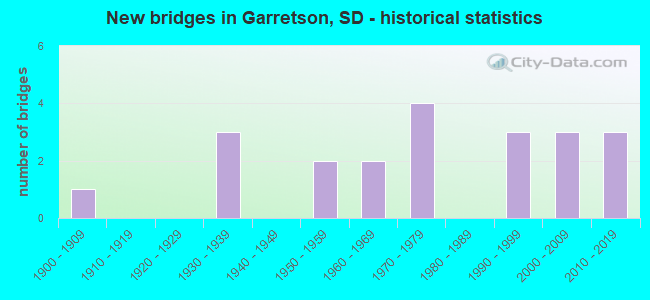
- New bridges - historical statistics
- 11900-1909
- 31930-1939
- 21950-1959
- 21960-1969
- 41970-1979
- 31990-1999
- 32000-2009
- 32010-2019


- Bridge Condition - Deck
- 25.0%Good
- 43.8%Satisfactory
- 25.0%Fair
- 6.3%Poor

- Bridge Condition - Superstructure
- 37.5%Good
- 37.5%Satisfactory
- 25.0%Fair

- Bridge Condition - Substructure
- 37.5%Good
- 43.8%Satisfactory
- 18.8%Fair

- Bridge Condition - Channel
- 23.8%Very good
- 38.1%Good
- 14.3%Satisfactory
- 19.0%Fair
- 4.8%Poor

- Bridge Condition - Culverts
- 60.0%Very good
- 20.0%Good
- 20.0%Fair
Find on map >> Show street view
Structure Number: 50280106, Location: 5.9 N I 90 INTERCH (Lat: 43.693594, Lng: -96.571272), Route carried "on" structure: State highway 11, Year Built: 2004, Status: Open, Structure Length: 0.69m (2.26ft), Average Daily Traffic: 3,950 (year 2021), Truck Traffic: 7%, Average Future Daily Traffic: 6,119 (year 2041), Design Load: HS 20+Mod, Features Intersected: TRIB TO W PIPESTONE CK
Minimum Vertical Clearance: 30+ m (98+ ft), Kilometerpoint: 139.691, Lanes on structure: 2, Base Highway Network: Yes, Owner: State Highway Agency, Approaching Roadway Width: 13.4m (44.0ft), Material/Design: Concrete continuous, Design/Construction: Culvert, Number Of Spans In Main Unit: 2, Length of Maximum Span: 3.4m (11.2ft)
Condition: Channel: Very good, Culverts: Very good, Structural Evaluation: Equal to present desirable criteria, Waterway Adequacy: Equal to present desirable criteria, Approach Roadway Alignment: Superior to present desirable criteria, Designated Inspection Frequency: Every 48 months, Inspection Date: October 2021
Find on map >> Show street view
Structure Number: 50280113, Location: 5.2 N I 90 INTERCH (Lat: 43.683297, Lng: -96.571261), Route carried "on" structure: State highway 11, Year Built: 1953, Status: Open, Structure Length: 4.62m (15.16ft), Average Daily Traffic: 3,950 (year 2021), Truck Traffic: 7%, Average Future Daily Traffic: 6,119 (year 2041), Design Load: H 20, Features Intersected: WEST PIPESTONE CK
Minimum Vertical Clearance: 30+ m (98+ ft), Kilometerpoint: 138.532, Lanes on structure: 2, Base Highway Network: Yes, Owner: State Highway Agency, Approaching Roadway Width: 9.1m (29.9ft), Material/Design: Concrete continuous, Design/Construction: Slab, Number Of Spans In Main Unit: 5, Length of Maximum Span: 9.4m (30.8ft), Curb-To-Curb Width: 9.1m (29.9ft), Out-to-Out Width: 10.5m (34.4ft)
Condition: Deck: Satisfactory, Superstructure: Satisfactory, Substructure: Satisfactory, Channel: Fair, Operating Rating: 55.1 metric tons, Method Used To Determine Operating Rating: Load Factor (LF), Inventory Rating: 33.0 metric tons, Method Used To Determine Inventory Rating: Load Factor (LF), Structural Evaluation: Equal to present minimum criteria, Deck Geometry: Meets minimum limits, Waterway Adequacy: Equal to present desirable criteria, Approach Roadway Alignment: Equal to present desirable criteria, Designated Inspection Frequency: Every 24 months, Inspection Date: July 2020, Deck Structure Type: Concrete Cast-file-Place, Wearing Surface/Protective System: Wearing Surface: Low Slump Concrete
Find on map >> Show street view
Structure Number: 5028211, Location: 6.5N & 0.2E BRANDON (Lat: 43.688056, Lng: -96.567606), Route carried "on" structure: County highway , Year Built: 1992, Status: Open, Structure Length: 2.65m (8.69ft), Average Daily Traffic: 35 (year 2020), Truck Traffic: 2%, Average Future Daily Traffic: 50 (year 2035), Design Load: HS 20+Mod, Features Intersected: WEST PIPESTONE CREEK, Facility Carried by Structure: 255TH STREET
Minimum Vertical Clearance: 30+ m (98+ ft), Kilometerpoint: 0.000, Lanes on structure: 2, Owner: County Highway Agency, Approaching Roadway Width: 7.3m (24.0ft), Material/Design: Concrete continuous, Design/Construction: Slab, Number Of Spans In Main Unit: 3, Length of Maximum Span: 10.0m (32.8ft), Curb-To-Curb Width: 9.8m (32.2ft), Out-to-Out Width: 10.0m (32.8ft)
Condition: Deck: Good, Superstructure: Good, Substructure: Satisfactory, Channel: Very good, Operating Rating: 72.4 metric tons, Method Used To Determine Operating Rating: Load Factor (LF), Inventory Rating: 43.4 metric tons, Method Used To Determine Inventory Rating: Load Factor (LF), Structural Evaluation: Equal to present minimum criteria, Deck Geometry: Equal to present desirable criteria, Waterway Adequacy: Equal to present desirable criteria, Approach Roadway Alignment: Equal to present desirable criteria, Length Of Structure Improvement: 3.56m (11.68ft), Designated Inspection Frequency: Every 24 months, Inspection Date: June 2020, Bridge Improvement Cost: $550,000, Roadway Improvement Cost: $55,000, Total Project Cost: $850,000 ( Estimate for 2018), Deck Structure Type: Concrete Cast-file-Place, Wearing Surface/Protective System: Wearing Surface: Monolithic Concrete
Find on map >> Show street view
Structure Number: 502841, Location: 6.8 N I 90 INTERCH (Lat: 43.702953, Lng: -96.561672), Route carried "on" structure: State highway 11, Year Built: 2005, Status: Open, Structure Length: 0.63m (2.07ft), Average Daily Traffic: 3,418 (year 2021), Truck Traffic: 7%, Average Future Daily Traffic: 5,294 (year 2041), Design Load: HS 20+Mod, Features Intersected: CK
Minimum Vertical Clearance: 30+ m (98+ ft), Kilometerpoint: 141.349, Lanes on structure: 2, Base Highway Network: Yes, Owner: State Highway Agency, Approaching Roadway Width: 13.4m (44.0ft), Material/Design: Concrete continuous, Design/Construction: Culvert, Number Of Spans In Main Unit: 2, Length of Maximum Span: 3.0m (9.8ft)
Condition: Channel: Very good, Culverts: Very good, Inventory Rating: 97.3 metric tons, Method Used To Determine Inventory Rating: Load Factor (LF), Structural Evaluation: Equal to present desirable criteria, Waterway Adequacy: Superior to present desirable criteria, Approach Roadway Alignment: Superior to present desirable criteria, Designated Inspection Frequency: Every 48 months, Inspection Date: October 2021
Find on map >> Show street view
Structure Number: 502881, Location: 7.2 N I 90 INTERCH (Lat: 43.702903, Lng: -96.554653), Route carried "on" structure: State highway 11, Year Built: 1950, Status: Open, Structure Length: 3.57m (11.71ft), Average Daily Traffic: 3,418 (year 2021), Truck Traffic: 7%, Average Future Daily Traffic: 5,294 (year 2041), Design Load: H 20, Features Intersected: WEST PIPESTONE CK
Minimum Vertical Clearance: 30+ m (98+ ft), Kilometerpoint: 141.912, Lanes on structure: 2, Base Highway Network: Yes, Owner: State Highway Agency, Approaching Roadway Width: 8.5m (27.9ft), Material/Design: Concrete continuous, Design/Construction: Slab, Number Of Spans In Main Unit: 5, Length of Maximum Span: 7.1m (23.3ft), Curb-To-Curb Width: 9.1m (29.9ft), Out-to-Out Width: 10.5m (34.4ft)
Condition: Deck: Satisfactory, Superstructure: Satisfactory, Substructure: Satisfactory, Channel: Satisfactory, Operating Rating: 47.5 metric tons, Method Used To Determine Operating Rating: Load Factor (LF), Inventory Rating: 28.5 metric tons, Method Used To Determine Inventory Rating: Load Factor (LF), Structural Evaluation: Equal to present minimum criteria, Deck Geometry: Meets minimum limits, Waterway Adequacy: Equal to present desirable criteria, Approach Roadway Alignment: Equal to present desirable criteria, Designated Inspection Frequency: Every 24 months, Underwater Inspection Frequency: Every 60 months, Inspection Date: July 2020, Underwater Inspection Date: October 2018, Deck Structure Type: Concrete Cast-file-Place, Wearing Surface/Protective System: Wearing Surface: Low Slump Concrete
Find on map >> Show street view
Structure Number: 5028906, Location: 4.1W SHERMAN (Lat: 43.761206, Lng: -96.552308), Route carried "on" structure: County highway , Year Built: 2015, Status: Open, Structure Length: 1.65m (5.41ft), Average Daily Traffic: 719 (year 2021), Truck Traffic: 3%, Average Future Daily Traffic: 850 (year 2036), Design Load: HL 93, Features Intersected: WEST PIPESTONE CK, Facility Carried by Structure: 250TH ST, HWY 114
Minimum Vertical Clearance: 30+ m (98+ ft), Kilometerpoint: 0.000, Lanes on structure: 2, Owner: County Highway Agency, Approaching Roadway Width: 7.9m (25.9ft), Material/Design: Prestressed concrete, Design/Construction: Stringer/Multi-beam, Number Of Spans In Main Unit: 1, Length of Maximum Span: 15.8m (51.8ft), Curb-To-Curb Width: 9.8m (32.2ft), Out-to-Out Width: 10.6m (34.8ft)
Condition: Deck: Good, Superstructure: Good, Substructure: Good, Channel: Good, Operating Rating: 82.1 metric tons, Method Used To Determine Operating Rating: Load and Resistance Factor (LRFR), Inventory Rating: 51.1 metric tons, Method Used To Determine Inventory Rating: Load and Resistance Factor (LRFR), Structural Evaluation: Better than present minimum criteria, Deck Geometry: Equal to present minimum criteria, Waterway Adequacy: Equal to present desirable criteria, Approach Roadway Alignment: Equal to present desirable criteria, Length Of Structure Improvement: 2.33m (7.64ft), Designated Inspection Frequency: Every 24 months, Inspection Date: June 2021, Bridge Improvement Cost: $344,000, Roadway Improvement Cost: $34,000, Total Project Cost: $559,000 ( Estimate for 2017), Deck Structure Type: Concrete Cast-file-Place, Wearing Surface/Protective System: Wearing Surface: Integral Concrete
Find on map >> Show street view
Structure Number: 5029407, Location: 3.6W & 1S SHERMAN (Lat: 43.746439, Lng: -96.542044), Route carried "on" structure: County highway , Year Built: 2014, Status: Open, Structure Length: 0.85m (2.79ft), Average Daily Traffic: 14 (year 2020), Truck Traffic: 2%, Average Future Daily Traffic: 50 (year 2035), Design Load: HL 93, Features Intersected: WEST PIPESTONE CK, Facility Carried by Structure: 251ST ST
Minimum Vertical Clearance: 30+ m (98+ ft), Kilometerpoint: 0.000, Lanes on structure: 2, Owner: County Highway Agency, Approaching Roadway Width: 5.5m (18.0ft), Material/Design: Concrete, Design/Construction: Slab, Number Of Spans In Main Unit: 1, Length of Maximum Span: 8.2m (26.9ft), Curb-To-Curb Width: 8.3m (27.2ft), Out-to-Out Width: 8.5m (27.9ft)
Condition: Deck: Good, Superstructure: Good, Substructure: Good, Channel: Good, Operating Rating: 75.7 metric tons, Method Used To Determine Operating Rating: Load and Resistance Factor (LRFR), Inventory Rating: 58.4 metric tons, Method Used To Determine Inventory Rating: Load and Resistance Factor (LRFR), Structural Evaluation: Better than present minimum criteria, Deck Geometry: Equal to present minimum criteria, Waterway Adequacy: Equal to present desirable criteria, Approach Roadway Alignment: Equal to present desirable criteria, Length Of Structure Improvement: 1.51m (4.95ft), Designated Inspection Frequency: Every 24 months, Inspection Date: June 2021, Bridge Improvement Cost: $223,000, Roadway Improvement Cost: $22,000, Total Project Cost: $384,000 ( Estimate for 2017), Deck Structure Type: Concrete Cast-file-Place, Wearing Surface/Protective System: Wearing Surface: Integral Concrete
Find on map >> Show street view
Structure Number: 5029609, Location: 1.4W GARRETSON (Lat: 43.717067, Lng: -96.537264), Route carried "on" structure: County highway , Year Built: 1972, Status: Open, Structure Length: 3.91m (12.83ft), Average Daily Traffic: 46 (year 2020), Truck Traffic: 2%, Average Future Daily Traffic: 75 (year 2035), Features Intersected: WEST PIPESTONE CREEK, Facility Carried by Structure: 253RD STREET
Minimum Vertical Clearance: 30+ m (98+ ft), Kilometerpoint: 0.000, Lanes on structure: 2, Owner: County Highway Agency, Approaching Roadway Width: 7.3m (24.0ft), Material/Design: Concrete continuous, Design/Construction: Slab, Number Of Spans In Main Unit: 5, Length of Maximum Span: 8.4m (27.6ft), Curb-To-Curb Width: 9.1m (29.9ft), Out-to-Out Width: 10.0m (32.8ft)
Condition: Deck: Satisfactory, Superstructure: Satisfactory, Substructure: Good, Channel: Good, Operating Rating: 32.7 metric tons, Method Used To Determine Operating Rating: Field evaluation and documented engineering judgment, Inventory Rating: 24.5 metric tons, Method Used To Determine Inventory Rating: Field evaluation and documented engineering judgment, Structural Evaluation: Equal to present minimum criteria, Deck Geometry: Better than present minimum criteria, Waterway Adequacy: Better than present minimum criteria, Approach Roadway Alignment: Equal to present minimum criteria, Length Of Structure Improvement: 4.86m (15.94ft), Designated Inspection Frequency: Every 24 months, Inspection Date: June 2020, Bridge Improvement Cost: $750,000, Roadway Improvement Cost: $75,000, Total Project Cost: $1,132,000 ( Estimate for 2018), Deck Structure Type: Concrete Cast-file-Place, Wearing Surface/Protective System: Wearing Surface: Monolithic Concrete
Find on map >> Show street view
Structure Number: 5029908, Location: 1.1W & 1N GARRETSON (Lat: 43.731275, Lng: -96.532236), Route carried "on" structure: County highway , Year Built: 1976, Status: Open, Structure Length: 1.73m (5.68ft), Average Daily Traffic: 28 (year 2020), Truck Traffic: 2%, Average Future Daily Traffic: 75 (year 2035), Features Intersected: WEST PIPESTONE CREEK, Facility Carried by Structure: 252ND STREET
Minimum Vertical Clearance: 30+ m (98+ ft), Kilometerpoint: 0.000, Lanes on structure: 2, Owner: County Highway Agency, Approaching Roadway Width: 6.7m (22.0ft), Skew: 3 degrees, Material/Design: Prestressed concrete, Design/Construction: Tee Beam, Number Of Spans In Main Unit: 1, Length of Maximum Span: 16.8m (55.1ft), Curb-To-Curb Width: 8.1m (26.6ft), Out-to-Out Width: 8.2m (26.9ft)
Condition: Deck: Fair, Superstructure: Fair, Substructure: Satisfactory, Channel: Fair, Operating Rating: 32.7 metric tons, Method Used To Determine Operating Rating: Field evaluation and documented engineering judgment, Inventory Rating: 24.5 metric tons, Method Used To Determine Inventory Rating: Field evaluation and documented engineering judgment, Structural Evaluation: Somewhat better than minimum adequacy, Deck Geometry: Equal to present minimum criteria, Waterway Adequacy: Equal to present minimum criteria, Approach Roadway Alignment: Equal to present minimum criteria, Length Of Structure Improvement: 2.42m (7.94ft), Designated Inspection Frequency: Every 24 months, Inspection Date: June 2020, Bridge Improvement Cost: $374,000, Roadway Improvement Cost: $37,000, Total Project Cost: $600,000 ( Estimate for 2018), Deck Structure Type: Concrete Precast Panels, Wearing Surface/Protective System: Wearing Surface: Monolithic Concrete
Find on map >> Show street view
Structure Number: 50300118, Location: 1W & 2.8S GARRETSON (Lat: 43.675639, Lng: -96.531350), Route carried "on" structure: County highway , Year Built: 1974, Status: Open, Structure Length: 7.79m (25.56ft), Average Daily Traffic: 352 (year 2021), Truck Traffic: 2%, Average Future Daily Traffic: 500 (year 2036), Design Load: HS 20, Features Intersected: SPLIT ROCK CREEK, Facility Carried by Structure: 484TH AVE, HWY 109
Minimum Vertical Clearance: 30+ m (98+ ft), Kilometerpoint: 0.000, Lanes on structure: 2, Owner: County Highway Agency, Approaching Roadway Width: 7.3m (24.0ft), Skew: 4 degrees, Material/Design: Steel continuous, Design/Construction: Stringer/Multi-beam, Number Of Spans In Main Unit: 3, Length of Maximum Span: 29.9m (98.1ft), Curb-To-Curb Width: 9.8m (32.2ft), Out-to-Out Width: 10.6m (34.8ft)
Condition: Deck: Satisfactory, Superstructure: Satisfactory, Substructure: Satisfactory, Channel: Poor, Operating Rating: 50.4 metric tons, Method Used To Determine Operating Rating: Load Factor (LF), Inventory Rating: 30.1 metric tons, Method Used To Determine Inventory Rating: Load Factor (LF), Structural Evaluation: Equal to present minimum criteria, Deck Geometry: Better than present minimum criteria, Waterway Adequacy: Better than present minimum criteria, Approach Roadway Alignment: Equal to present desirable criteria, Length Of Structure Improvement: 8.81m (28.90ft), Designated Inspection Frequency: Every 24 months, Inspection Date: June 2020, Bridge Improvement Cost: $1,359,000, Roadway Improvement Cost: $136,000, Total Project Cost: $1,998,000 ( Estimate for 2018), Deck Structure Type: Concrete Cast-file-Place, Wearing Surface/Protective System: Wearing Surface: Low Slump Concrete
Find on map >> Show street view
Structure Number: 5030711, Location: 1.5S & 0.5 W GARRETSON (Lat: 43.688969, Lng: -96.518353), Route carried "on" structure: State lands road , Year Built: 1908, Status: Posted for load, Structure Length: 3.63m (11.91ft), Average Daily Traffic: 35 (year 2019), Truck Traffic: 2%, Average Future Daily Traffic: 35 (year 2032), Features Intersected: SPLIT ROCK CK, Facility Carried by Structure: STATE PARK RD
Minimum Vertical Clearance: 4.32m (14.17ft), Kilometerpoint: 0.000, Lanes on structure: 2, Owner: State Agenciy, Approaching Roadway Width: 4.9m (16.1ft), Material/Design: Steel, Design/Construction: Truss - Thru, Number Of Spans In Main Unit: 1, Length of Maximum Span: 35.7m (117.1ft), Curb-To-Curb Width: 4.9m (16.1ft), Out-to-Out Width: 4.9m (16.1ft)
Condition: Deck: Fair, Superstructure: Fair, Substructure: Fair, Channel: Very good, Operating Rating: 3.6 metric tons, Method Used To Determine Operating Rating: Allowable Stress (AS), Inventory Rating: 2.7 metric tons, Method Used To Determine Inventory Rating: Allowable Stress (AS), Structural Evaluation: High priority of corrective action, Deck Geometry: High priority of corrective action, Waterway Adequacy: Superior to present desirable criteria, Approach Roadway Alignment: Equal to present desirable criteria, Bridge Posting: Required (Relationship of Operating Rating to Maximum Legal Load: > 39.9% below), Length Of Structure Improvement: 3.63m (11.91ft), Designated Inspection Frequency: Every 24 months, Critical Feature Inspection Frequency: Every 24 months, Inspection Date: October 2020, Critical Feature Inspection Date: October 2020, Bridge Improvement Cost: $300,000, Total Project Cost: $300,000 ( Estimate for 2020), Deck Structure Type: Wood or Timber, Wearing Surface/Protective System: Wearing Surface: Wood or Timber
Find on map >> Show street view
Structure Number: 503081, Location: 1.2 S GARRETSON (Lat: 43.703044, Lng: -96.515678), Route carried "on" structure: State highway 11, Year Built: 2005, Status: Open, Structure Length: 8.14m (26.71ft), Average Daily Traffic: 3,418 (year 2021), Truck Traffic: 7%, Average Future Daily Traffic: 5,294 (year 2041), Design Load: HS 25 or greater, Features Intersected: SPLIT ROCK CK
Minimum Vertical Clearance: 30+ m (98+ ft), Kilometerpoint: 145.082, Lanes on structure: 2, Base Highway Network: Yes, Owner: State Highway Agency, Approaching Roadway Width: 13.4m (44.0ft), Skew: 2 degrees, Material/Design: Prestressed concrete continuous, Design/Construction: Stringer/Multi-beam, Number Of Spans In Main Unit: 3, Length of Maximum Span: 28.1m (92.2ft), Curb-To-Curb Width: 12.2m (40.0ft), Out-to-Out Width: 13.0m (42.7ft)
Condition: Deck: Good, Superstructure: Good, Substructure: Good, Channel: Satisfactory, Operating Rating: 82.9 metric tons, Method Used To Determine Operating Rating: Load Factor (LF), Inventory Rating: 49.6 metric tons, Method Used To Determine Inventory Rating: Load Factor (LF), Structural Evaluation: Better than present minimum criteria, Deck Geometry: Equal to present minimum criteria, Waterway Adequacy: Superior to present desirable criteria, Approach Roadway Alignment: Superior to present desirable criteria, Designated Inspection Frequency: Every 24 months, Underwater Inspection Frequency: Every 60 months, Inspection Date: September 2020, Underwater Inspection Date: November 2018, Deck Structure Type: Concrete Cast-file-Place, Wearing Surface/Protective System: Wearing Surface: Integral Concrete, Deck Protection: Epoxy Coated Reinforcing
Find on map >> Show street view
Structure Number: 50310093, Location: 0.4 S OF GARRETSON (Lat: 43.713547, Lng: -96.511461), Route carried "on" structure: State highway 11, Year Built: 1964, Status: Open, Structure Length: 7.77m (25.49ft), Average Daily Traffic: 3,418 (year 2021), Truck Traffic: 7%, Average Future Daily Traffic: 5,294 (year 2041), Design Load: HS 20, Features Intersected: SPLIT ROCK CK
Minimum Vertical Clearance: 30+ m (98+ ft), Kilometerpoint: 146.499, Lanes on structure: 2, Base Highway Network: Yes, Owner: State Highway Agency, Approaching Roadway Width: 11.6m (38.1ft), Skew: 4 degrees, Material/Design: Prestressed concrete, Design/Construction: Stringer/Multi-beam, Number Of Spans In Main Unit: 4, Length of Maximum Span: 20.6m (67.6ft), Curb-To-Curb Width: 9.1m (29.9ft), Out-to-Out Width: 9.9m (32.5ft)
Condition: Deck: Satisfactory, Superstructure: Satisfactory, Substructure: Good, Channel: Fair, Operating Rating: 81.6 metric tons, Method Used To Determine Operating Rating: Load Factor (LF), Inventory Rating: 41.2 metric tons, Method Used To Determine Inventory Rating: Load Factor (LF), Structural Evaluation: Equal to present minimum criteria, Deck Geometry: Meets minimum limits, Waterway Adequacy: Equal to present minimum criteria, Approach Roadway Alignment: Equal to present desirable criteria, Designated Inspection Frequency: Every 24 months, Underwater Inspection Frequency: Every 60 months, Inspection Date: September 2020, Underwater Inspection Date: October 2018, Deck Structure Type: Concrete Cast-file-Place, Wearing Surface/Protective System: Wearing Surface: Low Slump Concrete
Find on map >> Show street view
Structure Number: 50310133, Location: 3E & 2.7N CORSON (Lat: 43.655628, Lng: -96.511653), Route carried "on" structure: County highway , Year Built: 1990, Status: Open, Structure Length: 1.58m (5.18ft), Average Daily Traffic: 18 (year 2020), Truck Traffic: 1%, Average Future Daily Traffic: 40 (year 2035), Features Intersected: TRIB TO SPLIT ROCK CK, Facility Carried by Structure: 485TH AVENUE
Minimum Vertical Clearance: 30+ m (98+ ft), Kilometerpoint: 0.000, Lanes on structure: 2, Owner: County Highway Agency, Approaching Roadway Width: 6.7m (22.0ft), Material/Design: Prestressed concrete, Design/Construction: Tee Beam, Number Of Spans In Main Unit: 1, Length of Maximum Span: 15.2m (49.9ft), Curb-To-Curb Width: 9.6m (31.5ft), Out-to-Out Width: 9.8m (32.2ft)
Condition: Deck: Satisfactory, Superstructure: Good, Substructure: Satisfactory, Channel: Good, Operating Rating: 32.7 metric tons, Method Used To Determine Operating Rating: Field evaluation and documented engineering judgment, Inventory Rating: 19.6 metric tons, Method Used To Determine Inventory Rating: Field evaluation and documented engineering judgment, Structural Evaluation: Somewhat better than minimum adequacy, Deck Geometry: Better than present minimum criteria, Waterway Adequacy: Equal to present desirable criteria, Approach Roadway Alignment: Equal to present minimum criteria, Length Of Structure Improvement: 2.27m (7.45ft), Designated Inspection Frequency: Every 24 months, Inspection Date: June 2020, Bridge Improvement Cost: $350,000, Roadway Improvement Cost: $35,000, Total Project Cost: $571,000 ( Estimate for 2018), Deck Structure Type: Concrete Precast Panels, Wearing Surface/Protective System: Wearing Surface: Monolithic Concrete
Find on map >> Show street view
Structure Number: 50313088, Location: west of N. Main Avenue (Lat: 43.718847, Lng: -96.504792), Route carried "on" structure: City street , Year Built: 1966, Status: Posted for load, Structure Length: 7.44m (24.41ft), Average Daily Traffic: 500 (year 2019), Truck Traffic: 2%, Average Future Daily Traffic: 500 (year 2032), Design Load: HS 20, Features Intersected: Split Rock Creek, Facility Carried by Structure: 5th Street
Minimum Vertical Clearance: 30+ m (98+ ft), Kilometerpoint: 0.000, Lanes on structure: 2, Owner: Town or Township Highway Agency, Approaching Roadway Width: 12.2m (40.0ft), Material/Design: Steel, Design/Construction: Arch - Deck, Number Of Spans In Main Unit: 1, Length of Maximum Span: 9.4m (30.8ft), Curb-To-Curb Width: 9.1m (29.9ft), Out-to-Out Width: 9.8m (32.2ft)
Condition: Deck: Fair, Superstructure: Fair, Substructure: Good, Channel: Very good, Operating Rating: 17.1 metric tons, Method Used To Determine Operating Rating: Field evaluation and documented engineering judgment, Inventory Rating: 13.2 metric tons, Method Used To Determine Inventory Rating: Field evaluation and documented engineering judgment, Structural Evaluation: Meets minimum limits, Deck Geometry: Equal to present minimum criteria, Waterway Adequacy: Equal to present desirable criteria, Approach Roadway Alignment: Better than present minimum criteria, Bridge Posting: Required (Relationship of Operating Rating to Maximum Legal Load: 20.0 - 29.9% below), Designated Inspection Frequency: Every 24 months, Critical Feature Inspection Frequency: Every 24 months, Inspection Date: October 2020, Critical Feature Inspection Date: October 2018, Deck Structure Type: Concrete Cast-file-Place, Wearing Surface/Protective System: Wearing Surface: Bituminous
Find on map >> Show street view
Structure Number: 5031502, Location: 7N & 0.5E GARRETSON (Lat: 43.820719, Lng: -96.503028), Route carried "on" structure: County highway , Year Built: 1992, Status: Open, Structure Length: 3.78m (12.40ft), Average Daily Traffic: 47 (year 2020), Average Future Daily Traffic: 75 (year 2035), Design Load: HS 20+Mod, Features Intersected: PIPESTONE CREEK, Facility Carried by Structure: 246TH STREET
Minimum Vertical Clearance: 30+ m (98+ ft), Kilometerpoint: 0.000, Lanes on structure: 2, Owner: County Highway Agency, Approaching Roadway Width: 7.3m (24.0ft), Material/Design: Concrete continuous, Design/Construction: Slab, Number Of Spans In Main Unit: 3, Length of Maximum Span: 14.3m (46.9ft), Curb-To-Curb Width: 9.8m (32.2ft), Out-to-Out Width: 10.0m (32.8ft)
Condition: Deck: Satisfactory, Superstructure: Good, Substructure: Satisfactory, Channel: Good, Operating Rating: 70.7 metric tons, Method Used To Determine Operating Rating: Load Factor (LF), Inventory Rating: 42.3 metric tons, Method Used To Determine Inventory Rating: Load Factor (LF), Structural Evaluation: Equal to present minimum criteria, Deck Geometry: Equal to present desirable criteria, Waterway Adequacy: Better than present minimum criteria, Approach Roadway Alignment: Equal to present desirable criteria, Length Of Structure Improvement: 4.71m (15.45ft), Designated Inspection Frequency: Every 24 months, Inspection Date: July 2020, Bridge Improvement Cost: $727,000, Roadway Improvement Cost: $73,000, Total Project Cost: $1,100,000 ( Estimate for 2018), Deck Structure Type: Concrete Cast-file-Place, Wearing Surface/Protective System: Wearing Surface: Monolithic Concrete
Find on map >> Show street view
Structure Number: 50315085, Location: north of 5th Street (Lat: 43.722269, Lng: -96.500675), Route carried "on" structure: City street , Year Built: 1935, Status: Posted for load, Structure Length: 1.68m (5.51ft), Average Daily Traffic: 30 (year 2019), Truck Traffic: 2%, Average Future Daily Traffic: 30 (year 2032), Features Intersected: Devils Gulch Creek, Facility Carried by Structure: Park Road
Minimum Vertical Clearance: 30+ m (98+ ft), Kilometerpoint: 0.000, Lanes on structure: 1, Owner: Town or Township Highway Agency, Approaching Roadway Width: 4.0m (13.1ft), Material/Design: Masonry, Design/Construction: Culvert, Number Of Spans In Main Unit: 4, Length of Maximum Span: 3.0m (9.8ft)
Condition: Channel: Satisfactory, Culverts: Fair, Operating Rating: 30.6 metric tons, Method Used To Determine Operating Rating: Field evaluation and documented engineering judgment, Inventory Rating: 22.4 metric tons, Method Used To Determine Inventory Rating: Field evaluation and documented engineering judgment, Structural Evaluation: Somewhat better than minimum adequacy, Waterway Adequacy: Equal to present desirable criteria, Approach Roadway Alignment: Equal to present minimum criteria, Bridge Posting: Required (Relationship of Operating Rating to Maximum Legal Load: 10.0 - 19.9% below), Designated Inspection Frequency: Every 24 months, Underwater Inspection Frequency: Every 60 months, Inspection Date: October 2020, Underwater Inspection Date: October 2018
Find on map >> Show street view
Structure Number: 5031513, Location: 4S & 0.5E GARRETSON (Lat: 43.659611, Lng: -96.501294), Route carried "on" structure: County highway , Year Built: 1938, Status: Open, Structure Length: 0.75m (2.46ft), Average Daily Traffic: 17 (year 2020), Truck Traffic: 2%, Average Future Daily Traffic: 40 (year 2035), Features Intersected: TRIB TO SPLIT ROCK CK, Facility Carried by Structure: 257TH STREET
Minimum Vertical Clearance: 30+ m (98+ ft), Kilometerpoint: 0.000, Lanes on structure: 2, Owner: County Highway Agency, Approaching Roadway Width: 7.3m (24.0ft), Material/Design: Concrete continuous, Design/Construction: Culvert, Number Of Spans In Main Unit: 2, Length of Maximum Span: 3.9m (12.8ft)
Condition: Channel: Fair, Culverts: Good, Structural Evaluation: Better than present minimum criteria, Waterway Adequacy: Equal to present desirable criteria, Approach Roadway Alignment: Equal to present minimum criteria, Length Of Structure Improvement: 1.22m (4.00ft), Designated Inspection Frequency: Every 48 months, Inspection Date: July 2018, Bridge Improvement Cost: $88,000, Roadway Improvement Cost: $9,000, Total Project Cost: $206,000 ( Estimate for 2018)
Find on map >> Show street view
Structure Number: 50330086, Location: 2E & 0.4N GARRETSON (Lat: 43.722931, Lng: -96.470839), Route carried "on" structure: County highway , Year Built: 1977, Status: Open, Structure Length: 1.58m (5.18ft), Average Daily Traffic: 317 (year 2021), Truck Traffic: 2%, Average Future Daily Traffic: 400 (year 2036), Features Intersected: TRIB TO SPLIT ROCK CK, Facility Carried by Structure: 487TH AVE, HWY 103
Minimum Vertical Clearance: 30+ m (98+ ft), Kilometerpoint: 0.000, Lanes on structure: 2, Owner: County Highway Agency, Approaching Roadway Width: 7.3m (24.0ft), Material/Design: Prestressed concrete, Design/Construction: Tee Beam, Number Of Spans In Main Unit: 1, Length of Maximum Span: 15.2m (49.9ft), Curb-To-Curb Width: 9.6m (31.5ft), Out-to-Out Width: 9.8m (32.2ft)
Condition: Deck: Poor, Superstructure: Satisfactory, Substructure: Fair, Channel: Good, Operating Rating: 32.7 metric tons, Method Used To Determine Operating Rating: Field evaluation and documented engineering judgment, Inventory Rating: 19.6 metric tons, Method Used To Determine Inventory Rating: Field evaluation and documented engineering judgment, Structural Evaluation: Somewhat better than minimum adequacy, Deck Geometry: Equal to present minimum criteria, Waterway Adequacy: Better than present minimum criteria, Approach Roadway Alignment: Better than present minimum criteria, Length Of Structure Improvement: 2.27m (7.45ft), Designated Inspection Frequency: Every 24 months, Inspection Date: June 2021, Bridge Improvement Cost: $334,000, Roadway Improvement Cost: $33,000, Total Project Cost: $543,000 ( Estimate for 2017), Deck Structure Type: Concrete Precast Panels, Wearing Surface/Protective System: Wearing Surface: Bituminous
Find on map >> Show street view
Structure Number: 5033509, Location: 2.4E GARRETSON (Lat: 43.718133, Lng: -96.461014), Route carried "on" structure: County highway , Year Built: 2010, Status: Open, Structure Length: 1.59m (5.22ft), Average Daily Traffic: 392 (year 2021), Truck Traffic: 3%, Average Future Daily Traffic: 450 (year 2036), Features Intersected: TRIB TO SPLIT ROCK CK, Facility Carried by Structure: 253RD ST, HWY 120
Minimum Vertical Clearance: 30+ m (98+ ft), Kilometerpoint: 0.000, Lanes on structure: 2, Owner: County Highway Agency, Approaching Roadway Width: 9.6m (31.5ft), Material/Design: Concrete continuous, Design/Construction: Culvert, Number Of Spans In Main Unit: 4, Length of Maximum Span: 3.9m (12.8ft)
Condition: Channel: Good, Culverts: Very good, Structural Evaluation: Equal to present desirable criteria, Waterway Adequacy: Equal to present desirable criteria, Approach Roadway Alignment: Equal to present desirable criteria, Length Of Structure Improvement: 1.58m (5.18ft), Designated Inspection Frequency: Every 48 months, Inspection Date: July 2018, Bridge Improvement Cost: $278,000, Roadway Improvement Cost: $28,000, Total Project Cost: $479,000 ( Estimate for 2018)
Find on map >> Show street view
Structure Number: 5033713, Location: 2.7E & 4S GARRETSON (Lat: 43.660383, Lng: -96.456719), Route carried "on" structure: County highway , Year Built: 1935, Status: Posted for load, Structure Length: 0.98m (3.22ft), Average Daily Traffic: 12 (year 2020), Truck Traffic: 2%, Average Future Daily Traffic: 40 (year 2035), Features Intersected: TRIB TO BEAVER CK, Facility Carried by Structure: 257TH STREET
Minimum Vertical Clearance: 30+ m (98+ ft), Kilometerpoint: 0.000, Lanes on structure: 2, Owner: County Highway Agency, Approaching Roadway Width: 5.5m (18.0ft), Material/Design: Steel, Design/Construction: Stringer/Multi-beam, Number Of Spans In Main Unit: 1, Length of Maximum Span: 9.4m (30.8ft), Curb-To-Curb Width: 5.8m (19.0ft), Out-to-Out Width: 6.1m (20.0ft)
Condition: Deck: Fair, Superstructure: Fair, Substructure: Fair, Channel: Good, Operating Rating: 27.8 metric tons, Method Used To Determine Operating Rating: Load Factor (LF), Inventory Rating: 16.6 metric tons, Method Used To Determine Inventory Rating: Load Factor (LF), Structural Evaluation: Somewhat better than minimum adequacy, Deck Geometry: Meets minimum limits, Waterway Adequacy: Somewhat better than minimum adequacy, Approach Roadway Alignment: Better than present minimum criteria, Bridge Posting: Required (Relationship of Operating Rating to Maximum Legal Load: 20.0 - 29.9% below), Length Of Structure Improvement: 1.65m (5.41ft), Designated Inspection Frequency: Every 24 months, Inspection Date: June 2020, Bridge Improvement Cost: $254,000, Roadway Improvement Cost: $25,000, Total Project Cost: $430,000 ( Estimate for 2018), Deck Structure Type: Concrete Cast-file-Place, Wearing Surface/Protective System: Wearing Surface: Monolithic Concrete