Bridge Statistics for Gaston, Indiana (IN)
Condition, Traffic, Stress, Structural Evaluation, Project Costs
- National Bridge Inventory (NBI) Statistics
- 27Number of bridges
- 148ft / 44.7mTotal length
- $1,930,000Total costs
- 105,016Total average daily traffic
- 21,615Total average daily truck traffic
- National Bridge Inventory (NBI) Registered Bridges for Gaston
- No street view available for this location
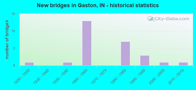
- New bridges - historical statistics
- 11930-1939
- 11950-1959
- 131960-1969
- 71980-1989
- 31990-1999
- 12000-2009
- 12010-2019

- Reconstructed bridges - Historical Statistics
- 11970-1979
- 01980-1989
- 01990-1999
- 02000-2009
- 02010-2019
- 42020-2022


- Bridge Condition - Deck
- 5.0%Excellent
- 10.0%Very good
- 30.0%Good
- 45.0%Satisfactory
- 10.0%Fair

- Bridge Condition - Superstructure
- 10.0%Very good
- 30.0%Good
- 55.0%Satisfactory
- 5.0%Fair

- Bridge Condition - Substructure
- 40.0%Good
- 50.0%Satisfactory
- 10.0%Fair

- Bridge Condition - Channel
- 4.8%Very good
- 23.8%Good
- 52.4%Satisfactory
- 19.0%Fair

- Bridge Condition - Culverts
- 33.3%Good
- 33.3%Satisfactory
- 33.3%Fair
Find on map >> Show street view
Structure Number: 778, Location: 3.85 E I-69 (Lat: 40.276989, Lng: -85.485111), Route carried "on" structure: US 35, Year Built: 1930, Year Reconstructed: 2020, Status: Open, Structure Length: 1.93m (6.33ft), Average Daily Traffic: 7,020 (year 2020), Truck Traffic: 30%, Average Future Daily Traffic: 8,301 (year 2040), Design Load: HS 20, Features Intersected: BIG KILLBUCK CREEK
Minimum Vertical Clearance: 30+ m (98+ ft), Kilometerpoint: 37.192, Lanes on structure: 2, Base Highway Network: Yes (, Subroute: 1), Owner: State Highway Agency, Approaching Roadway Width: 9.1m (29.9ft), Skew: 2 degrees, Material/Design: Steel, Design/Construction: Stringer/Multi-beam, Number Of Spans In Main Unit: 1, Length of Maximum Span: 18.3m (60.0ft), Curb-To-Curb Width: 11.3m (37.1ft), Out-to-Out Width: 12.2m (40.0ft)
Condition: Deck: Excellent, Superstructure: Satisfactory, Substructure: Satisfactory, Channel: Satisfactory, Operating Rating: 41.1 metric tons, Method Used To Determine Operating Rating: Load and Resistance Factor Rating (LRFR) rating reported by rating factor(RF) method using HL-93 loadings, Inventory Rating: 31.8 metric tons, Method Used To Determine Inventory Rating: Load and Resistance Factor Rating (LRFR) rating reported by rating factor(RF) method using HL-93 loadings, Structural Evaluation: Equal to present minimum criteria, Deck Geometry: Meets minimum limits, Waterway Adequacy: Superior to present desirable criteria, Approach Roadway Alignment: Equal to present desirable criteria, Designated Inspection Frequency: Every 24 months, Inspection Date: March 2021, Deck Structure Type: Concrete Cast-file-Place, Wearing Surface/Protective System: Wearing Surface: Monolithic Concrete, Deck Protection: Epoxy Coated Reinforcing
Find on map >> Show street view
Structure Number: 7785, Location: 0.73 E I-69 (Lat: 40.276700, Lng: -85.544011), Route carried "on" structure: US 35, Year Built: 1997, Status: Open, Structure Length: 0.66m (2.17ft), Average Daily Traffic: 5,945 (year 2004), Truck Traffic: 10%, Average Future Daily Traffic: 8,232 (year 2030), Design Load: HS 20, Features Intersected: YEAGER, FINLEY, MAYNARD
Minimum Vertical Clearance: 30+ m (98+ ft), Kilometerpoint: 42.213, Lanes on structure: 2, Base Highway Network: Yes (, Subroute: 1), Owner: State Highway Agency, Approaching Roadway Width: 9.1m (29.9ft), Material/Design: Concrete, Design/Construction: Culvert, Number Of Spans In Main Unit: 2, Length of Maximum Span: 3.0m (9.8ft)
Condition: Channel: Very good, Culverts: Good, Operating Rating: 54.5 metric tons, Method Used To Determine Operating Rating: Field evaluation and documented engineering judgment, Inventory Rating: 32.7 metric tons, Method Used To Determine Inventory Rating: Field evaluation and documented engineering judgment, Structural Evaluation: Better than present minimum criteria, Waterway Adequacy: Superior to present desirable criteria, Approach Roadway Alignment: Equal to present desirable criteria, Designated Inspection Frequency: Every 24 months, Inspection Date: March 2021
Find on map >> Show street view
Structure Number: 395, Location: 01.03 N SR 28 (Lat: 40.291469, Lng: -85.558219), Route carried "on" structure: Alternate County highway , Year Built: 1963, Year Reconstructed: 1981, Status: Open, Structure Length: 6.45m (21.16ft), Average Daily Traffic: 215 (year 2004), Truck Traffic: 10%, Average Future Daily Traffic: 358 (year 2029), Design Load: HS 20, Features Intersected: I-69, Facility Carried by Structure: CR 700 N
Minimum Vertical Clearance: 30+ m (98+ ft), Kilometerpoint: 0.000, Lanes on structure: 2, Lanes under structure: 4, Owner: State Highway Agency, Approaching Roadway Width: 6.1m (20.0ft), Material/Design: Concrete continuous, Design/Construction: Stringer/Multi-beam, Number Of Spans In Main Unit: 4, Length of Maximum Span: 19.9m (65.3ft), Curb or Sidewalk Widths: Left: 0.5m (1.6ft), Right: 0.5m (1.6ft), Curb-To-Curb Width: 7.3m (24.0ft), Out-to-Out Width: 9.0m (29.5ft)
Condition: Deck: Satisfactory, Superstructure: Satisfactory, Substructure: Satisfactory, Operating Rating: 49.8 metric tons, Method Used To Determine Operating Rating: Load Factor (LF), Inventory Rating: 29.8 metric tons, Method Used To Determine Inventory Rating: Load Factor (LF), Structural Evaluation: Equal to present minimum criteria, Deck Geometry: Somewhat better than minimum adequacy, Underclear: Meets minimum limits, Approach Roadway Alignment: Equal to present desirable criteria, Designated Inspection Frequency: Every 24 months, Inspection Date: August 2021, Deck Structure Type: Concrete Cast-file-Place, Wearing Surface/Protective System: Wearing Surface: Latex Concrete
Find on map >> Show street view
Structure Number: 3951, Location: 03.54 N SR 28 (Lat: 40.328119, Lng: -85.558950), Route carried "on" structure: Alternate County highway , Year Built: 1963, Year Reconstructed: 2020, Status: Open, Structure Length: 6.54m (21.46ft), Average Daily Traffic: 120 (year 2020), Truck Traffic: 3%, Average Future Daily Traffic: 120 (year 2040), Design Load: HS 20, Features Intersected: I-69, Facility Carried by Structure: CR 950 N
Minimum Vertical Clearance: 30+ m (98+ ft), Kilometerpoint: 0.000, Lanes on structure: 2, Lanes under structure: 4, Owner: State Highway Agency, Approaching Roadway Width: 6.1m (20.0ft), Material/Design: Concrete continuous, Design/Construction: Stringer/Multi-beam, Number Of Spans In Main Unit: 4, Length of Maximum Span: 20.1m (65.9ft), Curb-To-Curb Width: 7.3m (24.0ft), Out-to-Out Width: 9.0m (29.5ft)
Condition: Deck: Good, Superstructure: Satisfactory, Substructure: Good, Operating Rating: 40.8 metric tons, Method Used To Determine Operating Rating: Load and Resistance Factor Rating (LRFR) rating reported by rating factor(RF) method using HL-93 loadings, Inventory Rating: 29.5 metric tons, Method Used To Determine Inventory Rating: Load and Resistance Factor Rating (LRFR) rating reported by rating factor(RF) method using HL-93 loadings, Structural Evaluation: Equal to present minimum criteria, Deck Geometry: Somewhat better than minimum adequacy, Underclear: Meets minimum limits, Approach Roadway Alignment: Equal to present desirable criteria, Designated Inspection Frequency: Every 24 months, Inspection Date: August 2021, Deck Structure Type: Concrete Cast-file-Place, Wearing Surface/Protective System: Wearing Surface: Latex Concrete
Find on map >> Show street view
Structure Number: 3952, Location: 03.95 N SR 28 (Lat: 40.334161, Lng: -85.558989), Route carried "on" structure: Interstate 69, Year Built: 1963, Year Reconstructed: 2020, Status: Open, Structure Length: 2.98m (9.78ft), Average Daily Traffic: 15,800 (year 2017), Truck Traffic: 35%, Average Future Daily Traffic: 19,870 (year 2040), Design Load: HL 93, Features Intersected: PIPE CREEK
Minimum Vertical Clearance: 30+ m (98+ ft), Kilometerpoint: 400.179, Lanes on structure: 2, Base Highway Network: Yes (, Subroute: 1), Owner: State Highway Agency, Approaching Roadway Width: 12.0m (39.4ft), Skew: 3 degrees, Material/Design: Concrete continuous, Design/Construction: Slab, Number Of Spans In Main Unit: 3, Length of Maximum Span: 9.8m (32.2ft), Curb-To-Curb Width: 12.0m (39.4ft), Out-to-Out Width: 13.0m (42.7ft)
Condition: Deck: Very good, Superstructure: Very good, Substructure: Good, Channel: Good, Operating Rating: 45.4 metric tons, Method Used To Determine Operating Rating: Load and Resistance Factor Rating (LRFR) rating reported by rating factor(RF) method using HL-93 loadings, Inventory Rating: 35.0 metric tons, Method Used To Determine Inventory Rating: Load and Resistance Factor Rating (LRFR) rating reported by rating factor(RF) method using HL-93 loadings, Structural Evaluation: Better than present minimum criteria, Deck Geometry: Equal to present minimum criteria, Waterway Adequacy: Superior to present desirable criteria, Approach Roadway Alignment: Equal to present desirable criteria, Designated Inspection Frequency: Every 24 months, Inspection Date: August 2021, Deck Structure Type: Concrete Cast-file-Place, Wearing Surface/Protective System: Wearing Surface: Monolithic Concrete, Deck Protection: Epoxy Coated Reinforcing
Find on map >> Show street view
Structure Number: 3953, Location: 03.95 N SR 28 (Lat: 40.334000, Lng: -85.559269), Route carried "on" structure: Interstate 69, Year Built: 1963, Year Reconstructed: 2020, Status: Open, Structure Length: 2.98m (9.78ft), Average Daily Traffic: 15,470 (year 2017), Truck Traffic: 38%, Average Future Daily Traffic: 19,460 (year 2040), Design Load: HL 93, Features Intersected: PIPE CREEK
Minimum Vertical Clearance: 30+ m (98+ ft), Kilometerpoint: 400.179, Lanes on structure: 2, Base Highway Network: Yes (, Subroute: 1), Owner: State Highway Agency, Approaching Roadway Width: 11.6m (38.1ft), Skew: 3 degrees, Material/Design: Concrete continuous, Design/Construction: Slab, Number Of Spans In Main Unit: 3, Length of Maximum Span: 9.8m (32.2ft), Curb-To-Curb Width: 12.0m (39.4ft), Out-to-Out Width: 13.0m (42.7ft)
Condition: Deck: Very good, Superstructure: Very good, Substructure: Good, Channel: Good, Operating Rating: 45.4 metric tons, Method Used To Determine Operating Rating: Load and Resistance Factor Rating (LRFR) rating reported by rating factor(RF) method using HL-93 loadings, Inventory Rating: 35.0 metric tons, Method Used To Determine Inventory Rating: Load and Resistance Factor Rating (LRFR) rating reported by rating factor(RF) method using HL-93 loadings, Structural Evaluation: Better than present minimum criteria, Deck Geometry: Equal to present minimum criteria, Waterway Adequacy: Superior to present desirable criteria, Approach Roadway Alignment: Equal to present desirable criteria, Designated Inspection Frequency: Every 24 months, Inspection Date: August 2021, Deck Structure Type: Concrete Cast-file-Place, Wearing Surface/Protective System: Wearing Surface: Monolithic Concrete, Deck Protection: Epoxy Coated Reinforcing
Find on map >> Show street view
Structure Number: 1800001, Location: 00.30 N of CR 950 N (Lat: 40.332500, Lng: -85.563447), Route carried "on" structure: County highway 97, Year Built: 1961, Status: Open, Structure Length: 2.04m (6.69ft), Average Daily Traffic: 21 (year 2018), Truck Traffic: 1%, Average Future Daily Traffic: 30 (year 2038), Design Load: HS 20, Features Intersected: PIPE CREEK, Facility Carried by Structure: CR 925W
Minimum Vertical Clearance: 30+ m (98+ ft), Kilometerpoint: 0.000, Lanes on structure: 2, Owner: County Highway Agency, Approaching Roadway Width: 5.5m (18.0ft), Skew: 1 degrees, Material/Design: Concrete continuous, Design/Construction: Slab, Number Of Spans In Main Unit: 3, Length of Maximum Span: 7.6m (24.9ft), Curb or Sidewalk Widths: Left: 0.3m (1.0ft), Right: 0.3m (1.0ft), Curb-To-Curb Width: 6.7m (22.0ft), Out-to-Out Width: 7.9m (25.9ft)
Condition: Deck: Satisfactory, Superstructure: Satisfactory, Substructure: Good, Channel: Satisfactory, Operating Rating: 32.7 metric tons, Method Used To Determine Operating Rating: Field evaluation and documented engineering judgment, Inventory Rating: 32.7 metric tons, Method Used To Determine Inventory Rating: Field evaluation and documented engineering judgment, Structural Evaluation: Equal to present minimum criteria, Deck Geometry: Somewhat better than minimum adequacy, Waterway Adequacy: Better than present minimum criteria, Approach Roadway Alignment: Equal to present minimum criteria, Designated Inspection Frequency: Every 24 months, Inspection Date: October 2020, Deck Structure Type: Concrete Cast-file-Place, Wearing Surface/Protective System: Wearing Surface: Bituminous
Find on map >> Show street view
Structure Number: 1800003, Location: 00.25 N of CR 1000 N (Lat: 40.339200, Lng: -85.549333), Route carried "on" structure: County highway 9, Year Built: 1968, Status: Open, Structure Length: 1.71m (5.61ft), Average Daily Traffic: 62 (year 2018), Truck Traffic: 1%, Average Future Daily Traffic: 120 (year 2038), Design Load: HS 20, Features Intersected: PIPE CREEK, Facility Carried by Structure: CR 850W
Minimum Vertical Clearance: 30+ m (98+ ft), Kilometerpoint: 0.000, Lanes on structure: 2, Owner: County Highway Agency, Approaching Roadway Width: 5.5m (18.0ft), Skew: 2 degrees, Material/Design: Prestressed concrete, Design/Construction: Stringer/Multi-beam, Number Of Spans In Main Unit: 1, Length of Maximum Span: 16.5m (54.1ft), Curb or Sidewalk Widths: Left: 0.4m (1.3ft), Right: 0.4m (1.3ft), Curb-To-Curb Width: 7.3m (24.0ft), Out-to-Out Width: 8.0m (26.2ft)
Condition: Deck: Satisfactory, Superstructure: Good, Substructure: Satisfactory, Channel: Fair, Operating Rating: 32.7 metric tons, Method Used To Determine Operating Rating: Field evaluation and documented engineering judgment, Inventory Rating: 32.7 metric tons, Method Used To Determine Inventory Rating: Field evaluation and documented engineering judgment, Structural Evaluation: Equal to present minimum criteria, Deck Geometry: Equal to present minimum criteria, Waterway Adequacy: Equal to present minimum criteria, Approach Roadway Alignment: Equal to present minimum criteria, Length Of Structure Improvement: 1.71m (5.61ft), Designated Inspection Frequency: Every 24 months, Inspection Date: October 2020, Bridge Improvement Cost: $132,000, Roadway Improvement Cost: $190,000, Total Project Cost: $390,000 ( Estimate for 2021), Deck Structure Type: Concrete Cast-file-Place, Wearing Surface/Protective System: Wearing Surface: Monolithic Concrete
Find on map >> Show street view
Structure Number: 1800005, Location: 00.60 E CR 900 W (Lat: 40.313719, Lng: -85.546922), Route carried "on" structure: County highway 76, Year Built: 1987, Status: Open, Structure Length: 0.79m (2.59ft), Average Daily Traffic: 17 (year 2018), Truck Traffic: 1%, Average Future Daily Traffic: 30 (year 2038), Design Load: HS 20, Features Intersected: FINLEY-MANARD DITCH, Facility Carried by Structure: CR 850N
Minimum Vertical Clearance: 30+ m (98+ ft), Kilometerpoint: 0.000, Lanes on structure: 2, Owner: County Highway Agency, Approaching Roadway Width: 5.5m (18.0ft), Skew: 1 degrees, Material/Design: Wood or Timber, Design/Construction: Slab, Number Of Spans In Main Unit: 1, Length of Maximum Span: 7.6m (24.9ft), Curb or Sidewalk Widths: Left: 0.2m (0.7ft), Right: 0.2m (0.7ft), Curb-To-Curb Width: 7.4m (24.3ft), Out-to-Out Width: 7.8m (25.6ft)
Condition: Deck: Satisfactory, Superstructure: Satisfactory, Substructure: Satisfactory, Channel: Satisfactory, Operating Rating: 57.8 metric tons, Method Used To Determine Operating Rating: Load and Resistance Factor (LRFR), Inventory Rating: 42.9 metric tons, Method Used To Determine Inventory Rating: Load and Resistance Factor (LRFR), Structural Evaluation: Equal to present minimum criteria, Deck Geometry: Equal to present minimum criteria, Waterway Adequacy: Better than present minimum criteria, Approach Roadway Alignment: Equal to present desirable criteria, Designated Inspection Frequency: Every 24 months, Inspection Date: October 2020, Deck Structure Type: Wood or Timber, Wearing Surface/Protective System: Wearing Surface: Bituminous
Find on map >> Show street view
Structure Number: 1800006, Location: 00.15 S of CR 950 N (Lat: 40.326300, Lng: -85.529739), Route carried "on" structure: County highway 15, Year Built: 1987, Status: Open, Structure Length: 0.98m (3.22ft), Average Daily Traffic: 70 (year 2018), Truck Traffic: 1%, Average Future Daily Traffic: 130 (year 2038), Design Load: HS 20, Features Intersected: PIPE CREEK, Facility Carried by Structure: CR 750W
Minimum Vertical Clearance: 30+ m (98+ ft), Kilometerpoint: 0.000, Lanes on structure: 2, Owner: County Highway Agency, Approaching Roadway Width: 5.8m (19.0ft), Skew: 1 degrees, Material/Design: Wood or Timber, Design/Construction: Slab, Number Of Spans In Main Unit: 1, Length of Maximum Span: 9.1m (29.9ft), Curb or Sidewalk Widths: Left: 0.1m (0.3ft), Right: 0.1m (0.3ft), Curb-To-Curb Width: 7.5m (24.6ft), Out-to-Out Width: 7.8m (25.6ft)
Condition: Deck: Satisfactory, Superstructure: Satisfactory, Substructure: Satisfactory, Channel: Satisfactory, Operating Rating: 58.0 metric tons, Method Used To Determine Operating Rating: Load and Resistance Factor (LRFR), Inventory Rating: 43.1 metric tons, Method Used To Determine Inventory Rating: Load and Resistance Factor (LRFR), Structural Evaluation: Equal to present minimum criteria, Deck Geometry: Equal to present minimum criteria, Waterway Adequacy: Equal to present desirable criteria, Approach Roadway Alignment: Equal to present minimum criteria, Designated Inspection Frequency: Every 24 months, Inspection Date: October 2020, Deck Structure Type: Wood or Timber, Wearing Surface/Protective System: Wearing Surface: Bituminous
Find on map >> Show street view
Structure Number: 1800008, Location: 00.20 E of CR 675 W (Lat: 40.321000, Lng: -85.511192), Route carried "on" structure: County highway 216, Year Built: 1987, Status: Open, Structure Length: 0.98m (3.22ft), Average Daily Traffic: 45 (year 2018), Truck Traffic: 1%, Average Future Daily Traffic: 80 (year 2038), Design Load: HS 20, Features Intersected: PIPE CREEK, Facility Carried by Structure: CR 900N
Minimum Vertical Clearance: 30+ m (98+ ft), Kilometerpoint: 0.000, Lanes on structure: 2, Owner: County Highway Agency, Approaching Roadway Width: 4.9m (16.1ft), Skew: 3 degrees, Material/Design: Wood or Timber, Design/Construction: Slab, Number Of Spans In Main Unit: 1, Length of Maximum Span: 8.8m (28.9ft), Curb or Sidewalk Widths: Left: 0.2m (0.7ft), Right: 0.2m (0.7ft), Curb-To-Curb Width: 7.4m (24.3ft), Out-to-Out Width: 7.9m (25.9ft)
Condition: Deck: Good, Superstructure: Good, Substructure: Satisfactory, Channel: Satisfactory, Operating Rating: 59.4 metric tons, Method Used To Determine Operating Rating: Load and Resistance Factor (LRFR), Inventory Rating: 44.1 metric tons, Method Used To Determine Inventory Rating: Load and Resistance Factor (LRFR), Structural Evaluation: Equal to present minimum criteria, Deck Geometry: Equal to present minimum criteria, Waterway Adequacy: Equal to present minimum criteria, Approach Roadway Alignment: Equal to present minimum criteria, Designated Inspection Frequency: Every 24 months, Inspection Date: October 2020, Deck Structure Type: Wood or Timber, Wearing Surface/Protective System: Wearing Surface: Bituminous
Find on map >> Show street view
Structure Number: 1800009, Location: 00.25 W of CR 775 W (Lat: 40.335761, Lng: -85.539672), Route carried "on" structure: County highway , Year Built: 2004, Status: Open, Structure Length: 1.89m (6.20ft), Average Daily Traffic: 66 (year 2018), Truck Traffic: 1%, Average Future Daily Traffic: 120 (year 2038), Design Load: HS 20, Features Intersected: PIPE CREEK, Facility Carried by Structure: CR 1000N
Minimum Vertical Clearance: 30+ m (98+ ft), Kilometerpoint: 0.000, Lanes on structure: 2, Owner: County Highway Agency, Approaching Roadway Width: 5.5m (18.0ft), Material/Design: Wood or Timber, Design/Construction: Slab, Number Of Spans In Main Unit: 3, Length of Maximum Span: 7.9m (25.9ft), Curb or Sidewalk Widths: Left: 0.2m (0.7ft), Right: 0.2m (0.7ft), Curb-To-Curb Width: 7.9m (25.9ft), Out-to-Out Width: 8.4m (27.6ft)
Condition: Deck: Good, Superstructure: Good, Substructure: Good, Channel: Good, Operating Rating: 69.0 metric tons, Method Used To Determine Operating Rating: Load and Resistance Factor (LRFR), Inventory Rating: 51.3 metric tons, Method Used To Determine Inventory Rating: Load and Resistance Factor (LRFR), Structural Evaluation: Better than present minimum criteria, Deck Geometry: Equal to present minimum criteria, Waterway Adequacy: Better than present minimum criteria, Approach Roadway Alignment: Equal to present minimum criteria, Designated Inspection Frequency: Every 24 months, Inspection Date: October 2020, Deck Structure Type: Wood or Timber, Wearing Surface/Protective System: Wearing Surface: Bituminous
Find on map >> Show street view
Structure Number: 180001, Location: 00.25 N of CR 1000 N (Lat: 40.339150, Lng: -85.444108), Route carried "on" structure: County highway 169, Year Built: 1969, Status: Open, Structure Length: 2.19m (7.19ft), Average Daily Traffic: 113 (year 2018), Truck Traffic: 1%, Average Future Daily Traffic: 210 (year 2038), Design Load: HS 20, Features Intersected: STUDEBAKER DITCH, Facility Carried by Structure: CR 300W
Minimum Vertical Clearance: 30+ m (98+ ft), Kilometerpoint: 0.000, Lanes on structure: 2, Owner: County Highway Agency, Approaching Roadway Width: 5.5m (18.0ft), Material/Design: Concrete continuous, Design/Construction: Slab, Number Of Spans In Main Unit: 3, Length of Maximum Span: 8.5m (27.9ft), Curb or Sidewalk Widths: Left: 0.3m (1.0ft), Right: 0.3m (1.0ft), Curb-To-Curb Width: 6.7m (22.0ft), Out-to-Out Width: 7.3m (24.0ft)
Condition: Deck: Satisfactory, Superstructure: Satisfactory, Substructure: Satisfactory, Channel: Satisfactory, Operating Rating: 32.7 metric tons, Method Used To Determine Operating Rating: Field evaluation and documented engineering judgment, Inventory Rating: 32.7 metric tons, Method Used To Determine Inventory Rating: Field evaluation and documented engineering judgment, Structural Evaluation: Equal to present minimum criteria, Deck Geometry: Meets minimum limits, Waterway Adequacy: Equal to present minimum criteria, Approach Roadway Alignment: Equal to present minimum criteria, Length Of Structure Improvement: 2.19m (7.19ft), Designated Inspection Frequency: Every 24 months, Inspection Date: November 2020, Bridge Improvement Cost: $170,000, Roadway Improvement Cost: $190,000, Total Project Cost: $436,000 ( Estimate for 2021), Deck Structure Type: Concrete Cast-file-Place, Wearing Surface/Protective System: Wearing Surface: Monolithic Concrete
Find on map >> Show street view
Structure Number: 1800013, Location: 00.20 NW of CR 950 N (Lat: 40.331039, Lng: -85.460786), Route carried "on" structure: County highway , Year Built: 1965, Status: Open, Structure Length: 0.85m (2.79ft), Average Daily Traffic: 1,272 (year 2018), Truck Traffic: 3%, Average Future Daily Traffic: 2,310 (year 2038), Design Load: HS 20, Features Intersected: HAYDEN DITCH, Facility Carried by Structure: WHEELING AVENUE
Minimum Vertical Clearance: 30+ m (98+ ft), Kilometerpoint: 0.000, Lanes on structure: 2, Owner: County Highway Agency, Approaching Roadway Width: 7.9m (25.9ft), Skew: 3 degrees, Material/Design: Prestressed concrete, Design/Construction: Box Beam or Girders - Multiple, Number Of Spans In Main Unit: 1, Length of Maximum Span: 7.9m (25.9ft), Curb or Sidewalk Widths: Left: 0.1m (0.3ft), Right: 0.1m (0.3ft), Curb-To-Curb Width: 8.5m (27.9ft), Out-to-Out Width: 9.1m (29.9ft)
Condition: Deck: Fair, Superstructure: Fair, Substructure: Satisfactory, Channel: Fair, Operating Rating: 52.2 metric tons, Method Used To Determine Operating Rating: Load and Resistance Factor (LRFR), Inventory Rating: 34.8 metric tons, Method Used To Determine Inventory Rating: Load and Resistance Factor (LRFR), Structural Evaluation: Somewhat better than minimum adequacy, Deck Geometry: Somewhat better than minimum adequacy, Waterway Adequacy: Somewhat better than minimum adequacy, Approach Roadway Alignment: Equal to present desirable criteria, Designated Inspection Frequency: Every 24 months, Inspection Date: October 2020, Deck Structure Type: Concrete Precast Panels, Wearing Surface/Protective System: Wearing Surface: Bituminous
Find on map >> Show street view
Structure Number: 1800014, Location: 00.15 W CR 825 W (Lat: 40.306400, Lng: -85.548111), Route carried "on" structure: County highway 204, Year Built: 1985, Status: Open, Structure Length: 1.08m (3.54ft), Average Daily Traffic: 18 (year 2018), Truck Traffic: 1%, Average Future Daily Traffic: 30 (year 2038), Features Intersected: FINLEY-MANARD DITCH, Facility Carried by Structure: CR 800N
Minimum Vertical Clearance: 30+ m (98+ ft), Kilometerpoint: 0.000, Lanes on structure: 2, Owner: County Highway Agency, Approaching Roadway Width: 4.9m (16.1ft), Material/Design: Steel, Design/Construction: Stringer/Multi-beam, Number Of Spans In Main Unit: 1, Length of Maximum Span: 10.2m (33.5ft), Curb or Sidewalk Widths: Left: 0.2m (0.7ft), Right: 0.2m (0.7ft), Curb-To-Curb Width: 6.9m (22.6ft), Out-to-Out Width: 7.3m (24.0ft)
Condition: Deck: Fair, Superstructure: Satisfactory, Substructure: Good, Channel: Satisfactory, Operating Rating: 47.7 metric tons, Method Used To Determine Operating Rating: Load Factor (LF), Inventory Rating: 28.6 metric tons, Method Used To Determine Inventory Rating: Load Factor (LF), Structural Evaluation: Equal to present minimum criteria, Deck Geometry: Somewhat better than minimum adequacy, Waterway Adequacy: Equal to present minimum criteria, Approach Roadway Alignment: Equal to present minimum criteria, Designated Inspection Frequency: Every 24 months, Inspection Date: October 2020, Deck Structure Type: Wood or Timber, Wearing Surface/Protective System: Wearing Surface: Wood or Timber
Find on map >> Show street view
Structure Number: 1800048, Location: 00.50 SE of CR 750 N (Lat: 40.293419, Lng: -85.446106), Route carried "on" structure: County highway , Year Built: 1994, Status: Open, Structure Length: 0.67m (2.20ft), Average Daily Traffic: 3,895 (year 2018), Truck Traffic: 3%, Average Future Daily Traffic: 7,070 (year 2038), Design Load: HS 20, Features Intersected: KILLBUCK CREEK, Facility Carried by Structure: WHEELING AVE
Minimum Vertical Clearance: 30+ m (98+ ft), Kilometerpoint: 0.000, Lanes on structure: 2, Owner: County Highway Agency, Approaching Roadway Width: 6.7m (22.0ft), Skew: 3 degrees, Material/Design: Steel, Design/Construction: Culvert, Number Of Spans In Main Unit: 1, Length of Maximum Span: 6.4m (21.0ft)
Condition: Channel: Satisfactory, Culverts: Fair, Operating Rating: 99.2 metric tons, Method Used To Determine Operating Rating: Load and Resistance Factor (LRFR), Inventory Rating: 64.5 metric tons, Method Used To Determine Inventory Rating: Load and Resistance Factor (LRFR), Structural Evaluation: Somewhat better than minimum adequacy, Waterway Adequacy: Better than present minimum criteria, Approach Roadway Alignment: Equal to present desirable criteria, Length Of Structure Improvement: 1.31m (4.30ft), Designated Inspection Frequency: Every 24 months, Inspection Date: October 2020, Bridge Improvement Cost: $240,000, Roadway Improvement Cost: $205,000, Total Project Cost: $543,000 ( Estimate for 2021), Wearing Surface/Protective System: Wearing Surface: Bituminous
Find on map >> Show street view
Structure Number: 1800049, Location: 00.10 N of CR 650 N (Lat: 40.285550, Lng: -85.472108), Route carried "on" structure: County highway 33, Year Built: 1968, Status: Open, Structure Length: 2.53m (8.30ft), Average Daily Traffic: 561 (year 2018), Truck Traffic: 1%, Average Future Daily Traffic: 1,020 (year 2038), Design Load: HS 20, Features Intersected: KILLBUCK CREEK, Facility Carried by Structure: CR 450W
Minimum Vertical Clearance: 30+ m (98+ ft), Kilometerpoint: 0.000, Lanes on structure: 2, Owner: County Highway Agency, Approaching Roadway Width: 6.1m (20.0ft), Skew: 3 degrees, Material/Design: Concrete continuous, Design/Construction: Slab, Number Of Spans In Main Unit: 3, Length of Maximum Span: 9.8m (32.2ft), Curb or Sidewalk Widths: Left: 0.3m (1.0ft), Right: 0.3m (1.0ft), Curb-To-Curb Width: 7.0m (23.0ft), Out-to-Out Width: 8.2m (26.9ft)
Condition: Deck: Satisfactory, Superstructure: Satisfactory, Substructure: Fair, Channel: Fair, Operating Rating: 54.8 metric tons, Method Used To Determine Operating Rating: Load Factor (LF), Inventory Rating: 32.8 metric tons, Method Used To Determine Inventory Rating: Load Factor (LF), Structural Evaluation: Somewhat better than minimum adequacy, Deck Geometry: Meets minimum limits, Waterway Adequacy: Equal to present minimum criteria, Approach Roadway Alignment: Equal to present minimum criteria, Designated Inspection Frequency: Every 24 months, Inspection Date: October 2020, Deck Structure Type: Concrete Cast-file-Place, Wearing Surface/Protective System: Wearing Surface: Bituminous
Find on map >> Show street view
Structure Number: 1800058, Location: 00.40 S of SR 28 (Lat: 40.270861, Lng: -85.500847), Route carried "on" structure: County highway 25, Year Built: 1951, Status: Open, Structure Length: 3.11m (10.20ft), Average Daily Traffic: 2,611 (year 2018), Truck Traffic: 3%, Average Future Daily Traffic: 4,740 (year 2038), Design Load: HS 15, Features Intersected: KILLBUCK CREEK, Facility Carried by Structure: CR 600W
Minimum Vertical Clearance: 30+ m (98+ ft), Kilometerpoint: 0.000, Lanes on structure: 2, Owner: County Highway Agency, Approaching Roadway Width: 6.7m (22.0ft), Skew: 2 degrees, Material/Design: Concrete continuous, Design/Construction: Slab, Number Of Spans In Main Unit: 3, Length of Maximum Span: 11.3m (37.1ft), Curb or Sidewalk Widths: Left: 0.3m (1.0ft), Right: 0.3m (1.0ft), Curb-To-Curb Width: 7.3m (24.0ft), Out-to-Out Width: 8.5m (27.9ft)
Condition: Deck: Satisfactory, Superstructure: Satisfactory, Substructure: Satisfactory, Channel: Satisfactory, Operating Rating: 32.7 metric tons, Method Used To Determine Operating Rating: Field evaluation and documented engineering judgment, Inventory Rating: 32.7 metric tons, Method Used To Determine Inventory Rating: Field evaluation and documented engineering judgment, Structural Evaluation: Equal to present minimum criteria, Deck Geometry: High priority of replacement, Waterway Adequacy: Better than present minimum criteria, Approach Roadway Alignment: Equal to present minimum criteria, Designated Inspection Frequency: Every 24 months, Inspection Date: October 2020, Bridge Improvement Cost: $273,000, Roadway Improvement Cost: $190,000, Total Project Cost: $561,000 ( Estimate for 2021), Deck Structure Type: Concrete Cast-file-Place, Wearing Surface/Protective System: Wearing Surface: Other
Find on map >> Show street view
Structure Number: 1800201, Location: 00.35 S of MOORE Rd (Lat: 40.235939, Lng: -85.442772), Route carried "on" structure: City street 323, Year Built: 1983, Status: Open, Structure Length: 0.73m (2.40ft), Average Daily Traffic: 3,253 (year 2018), Truck Traffic: 1%, Average Future Daily Traffic: 5,900 (year 2038), Design Load: HS 20, Features Intersected: EAGLE BRACH CREEK, Facility Carried by Structure: MORRISON ROAD
Minimum Vertical Clearance: 30+ m (98+ ft), Kilometerpoint: 0.000, Lanes on structure: 2, Owner: County Highway Agency, Approaching Roadway Width: 6.7m (22.0ft), Material/Design: Prestressed concrete, Design/Construction: Box Beam or Girders - Multiple, Number Of Spans In Main Unit: 1, Length of Maximum Span: 6.7m (22.0ft), Curb-To-Curb Width: 9.7m (31.8ft), Out-to-Out Width: 9.9m (32.5ft)
Condition: Deck: Good, Superstructure: Good, Substructure: Fair, Channel: Fair, Operating Rating: 57.9 metric tons, Method Used To Determine Operating Rating: Load and Resistance Factor (LRFR), Inventory Rating: 39.6 metric tons, Method Used To Determine Inventory Rating: Load and Resistance Factor (LRFR), Structural Evaluation: Somewhat better than minimum adequacy, Deck Geometry: Meets minimum limits, Waterway Adequacy: Equal to present minimum criteria, Approach Roadway Alignment: Equal to present minimum criteria, Designated Inspection Frequency: Every 24 months, Inspection Date: October 2020, Deck Structure Type: Concrete Precast Panels, Wearing Surface/Protective System: Wearing Surface: Bituminous
Find on map >> Show street view
Structure Number: 1800207, Location: 00.04 E of BROAD St (Lat: 40.312869, Lng: -85.504828), Route carried "on" structure: City street , Year Built: 1981, Status: Open, Structure Length: 0.81m (2.66ft), Average Daily Traffic: 44 (year 2018), Truck Traffic: 1%, Average Future Daily Traffic: 80 (year 2038), Design Load: HS 20, Features Intersected: PIPE CREEK, Facility Carried by Structure: W. MILL ST
Minimum Vertical Clearance: 30+ m (98+ ft), Kilometerpoint: 0.000, Lanes on structure: 2, Owner: County Highway Agency, Approaching Roadway Width: 7.0m (23.0ft), Skew: 2 degrees, Material/Design: Wood or Timber, Design/Construction: Slab, Number Of Spans In Main Unit: 1, Length of Maximum Span: 7.5m (24.6ft), Curb or Sidewalk Widths: Left: 0.1m (0.3ft), Right: 2.3m (7.5ft), Curb-To-Curb Width: 7.7m (25.3ft), Out-to-Out Width: 10.1m (33.1ft)
Condition: Deck: Satisfactory, Superstructure: Satisfactory, Substructure: Satisfactory, Channel: Satisfactory, Operating Rating: 53.6 metric tons, Method Used To Determine Operating Rating: Load and Resistance Factor (LRFR), Inventory Rating: 34.6 metric tons, Method Used To Determine Inventory Rating: Load and Resistance Factor (LRFR), Structural Evaluation: Equal to present minimum criteria, Deck Geometry: Equal to present minimum criteria, Waterway Adequacy: Better than present minimum criteria, Approach Roadway Alignment: Equal to present minimum criteria, Designated Inspection Frequency: Every 24 months, Inspection Date: October 2020, Deck Structure Type: Wood or Timber, Wearing Surface/Protective System: Wearing Surface: Bituminous
Find on map >> Show street view
Structure Number: 1800212, Location: 00.07 E of N WHEELING Ave (Lat: 40.345400, Lng: -85.464217), Route carried "on" structure: County highway 236, Year Built: 1994, Status: Open, Structure Length: 0.79m (2.59ft), Average Daily Traffic: 160 (year 2018), Truck Traffic: 1%, Average Future Daily Traffic: 300 (year 2038), Design Load: HS 20, Features Intersected: HEDGELAND DITCH, Facility Carried by Structure: CR 1070N
Minimum Vertical Clearance: 30+ m (98+ ft), Kilometerpoint: 0.000, Lanes on structure: 2, Owner: County Highway Agency, Approaching Roadway Width: 4.0m (13.1ft), Material/Design: Wood or Timber, Design/Construction: Slab, Number Of Spans In Main Unit: 1, Length of Maximum Span: 7.9m (25.9ft), Curb or Sidewalk Widths: Left: 0.1m (0.3ft), Right: 0.1m (0.3ft), Curb-To-Curb Width: 8.1m (26.6ft), Out-to-Out Width: 8.4m (27.6ft)
Condition: Deck: Good, Superstructure: Good, Substructure: Good, Channel: Good, Operating Rating: 50.2 metric tons, Method Used To Determine Operating Rating: Load and Resistance Factor (LRFR), Inventory Rating: 37.3 metric tons, Method Used To Determine Inventory Rating: Load and Resistance Factor (LRFR), Structural Evaluation: Better than present minimum criteria, Deck Geometry: Somewhat better than minimum adequacy, Waterway Adequacy: Equal to present desirable criteria, Approach Roadway Alignment: Equal to present minimum criteria, Designated Inspection Frequency: Every 24 months, Inspection Date: October 2020, Deck Structure Type: Wood or Timber, Wearing Surface/Protective System: Wearing Surface: Bituminous
Find on map >> Show street view
Structure Number: 1800602, Location: 00.50 W OF CR 950 N (Lat: 40.328439, Lng: -85.539864), Route carried "on" structure: County highway 208, Year Built: 2010, Status: Open, Structure Length: 1.40m (4.59ft), Average Daily Traffic: 74 (year 2018), Truck Traffic: 1%, Average Future Daily Traffic: 130 (year 2038), Design Load: HS 20, Features Intersected: PIPE CREEK, Facility Carried by Structure: CR 950N
Minimum Vertical Clearance: 30+ m (98+ ft), Kilometerpoint: 0.000, Lanes on structure: 2, Owner: County Highway Agency, Approaching Roadway Width: 7.0m (23.0ft), Skew: 2 degrees, Material/Design: Concrete, Design/Construction: Slab, Number Of Spans In Main Unit: 1, Length of Maximum Span: 12.8m (42.0ft), Curb-To-Curb Width: 7.2m (23.6ft), Out-to-Out Width: 7.4m (24.3ft)
Condition: Deck: Good, Superstructure: Good, Substructure: Good, Channel: Good, Operating Rating: 45.2 metric tons, Method Used To Determine Operating Rating: Load and Resistance Factor (LRFR), Inventory Rating: 37.5 metric tons, Method Used To Determine Inventory Rating: Load and Resistance Factor (LRFR), Structural Evaluation: Better than present minimum criteria, Deck Geometry: Somewhat better than minimum adequacy, Waterway Adequacy: Better than present minimum criteria, Approach Roadway Alignment: Equal to present desirable criteria, Designated Inspection Frequency: Every 24 months, Inspection Date: October 2020, Deck Structure Type: Concrete Cast-file-Place, Wearing Surface/Protective System: Wearing Surface: Monolithic Concrete, Deck Protection: Epoxy Coated Reinforcing
Find on map >> Show street view
Structure Number: 180061, Location: 00.28 E of CR 500 W (Lat: 40.335739, Lng: -85.476669), Route carried "on" structure: County highway 1000, Year Built: 1980, Status: Open, Structure Length: 0.61m (2.00ft), Average Daily Traffic: 66 (year 2018), Truck Traffic: 1%, Average Future Daily Traffic: 128 (year 2038), Features Intersected: LOVE DITCH
Minimum Vertical Clearance: 30+ m (98+ ft), Kilometerpoint: 0.000, Lanes on structure: 2, Owner: County Highway Agency, Approaching Roadway Width: 6.1m (20.0ft), Skew: 6 degrees, Material/Design: Aluminum, Iron, Design/Construction: Culvert, Number Of Spans In Main Unit: 1, Length of Maximum Span: 6.1m (20.0ft)
Condition: Channel: Satisfactory, Culverts: Satisfactory, Operating Rating: 59.9 metric tons, Method Used To Determine Operating Rating: Load and Resistance Factor (LRFR), Inventory Rating: 47.5 metric tons, Method Used To Determine Inventory Rating: Load and Resistance Factor (LRFR), Structural Evaluation: Equal to present minimum criteria, Waterway Adequacy: Equal to present minimum criteria, Approach Roadway Alignment: Equal to present minimum criteria, Designated Inspection Frequency: Every 24 months, Inspection Date: October 2020
Find on map >> Show street view
Structure Number: 395, Location: 01.03 N SR 28 (Lat: 40.291469, Lng: -85.558219), Route carried "under" structure: Interstate 69, Year Built: 1963, Structure Length: 0. m, Average Daily Traffic: 12,024 (year 2004), Truck Traffic: 15%, Features Intersected: I-69 NBL, Facility Carried by Structure: CR 700N
Minimum Vertical Clearance: 5.33m (17.49ft), Kilometerpoint: 395.480, Lanes on structure: 2, Lanes under structure: 4, Material/Design: Concrete continuous, Design/Construction: Stringer/Multi-beam, Length of Maximum Span: 19.9m (65.3ft)
Find on map >> Show street view
Structure Number: 395, Location: 01.03 N SR 28 (Lat: 40.291469, Lng: -85.558219), Route carried "under" structure: Interstate 69, Year Built: 1963, Structure Length: 0. m, Average Daily Traffic: 12,025 (year 2004), Truck Traffic: 15%, Features Intersected: I-69 SBL, Facility Carried by Structure: CR 700N
Minimum Vertical Clearance: 5.31m (17.42ft), Kilometerpoint: 395.480, Lanes on structure: 2, Lanes under structure: 4, Material/Design: Concrete continuous, Design/Construction: Stringer/Multi-beam, Length of Maximum Span: 19.9m (65.3ft)
Find on map >> Show street view
Structure Number: 3951, Location: 03.54 N SR 28 (Lat: 40.328119, Lng: -85.558950), Route carried "under" structure: Interstate 69, Year Built: 1963, Structure Length: 0. m, Average Daily Traffic: 12,024 (year 2004), Truck Traffic: 15%, Features Intersected: I-69 NBL, Facility Carried by Structure: CR 950N
Minimum Vertical Clearance: 5.26m (17.26ft), Kilometerpoint: 399.520, Lanes on structure: 2, Lanes under structure: 4, Material/Design: Concrete continuous, Design/Construction: Stringer/Multi-beam, Length of Maximum Span: 20.1m (65.9ft)
Find on map >> Show street view
Structure Number: 3951, Location: 03.54 N SR 28 (Lat: 40.328119, Lng: -85.558950), Route carried "under" structure: Interstate 69, Year Built: 1963, Structure Length: 0. m, Average Daily Traffic: 12,025 (year 2004), Truck Traffic: 15%, Features Intersected: I-69 SBL, Facility Carried by Structure: CR 950N
Minimum Vertical Clearance: 5.28m (17.32ft), Kilometerpoint: 399.520, Lanes on structure: 2, Lanes under structure: 4, Material/Design: Concrete continuous, Design/Construction: Stringer/Multi-beam, Length of Maximum Span: 20.1m (65.9ft)