Bridge Statistics for Geistown, Pennsylvania (PA)
Condition, Traffic, Stress, Structural Evaluation, Project Costs
- National Bridge Inventory (NBI) Statistics
- 18Number of bridges
- 102ft / 30.9mTotal length
- 204,338Total average daily traffic
- 14,372Total average daily truck traffic
- National Bridge Inventory (NBI) Registered Bridges for Geistown
- No street view available for this location
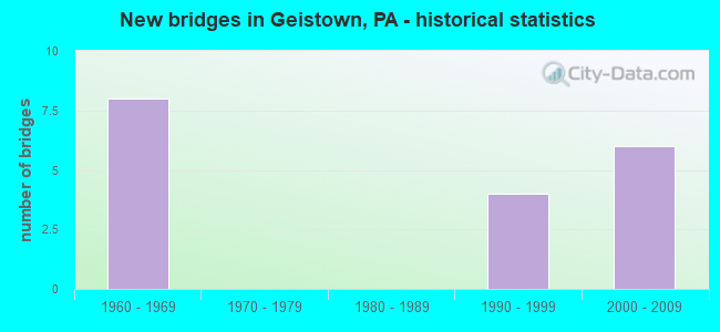
- New bridges - historical statistics
- 81960-1969
- 41990-1999
- 62000-2009

- Reconstructed bridges - Historical Statistics
- 11980-1989
- 01990-1999
- 12000-2009
- 12010-2019


- Bridge Condition - Deck
- 80.0%Good
- 20.0%Satisfactory

- Bridge Condition - Superstructure
- 60.0%Good
- 40.0%Satisfactory

- Bridge Condition - Substructure
- 20.0%Very good
- 40.0%Good
- 40.0%Satisfactory
Find on map >> Show street view
Structure Number: 8444, Location: OVER PA 56 EAST (Lat: 40.273364, Lng: -78.859058), Route carried "on" structure: US 219, Year Built: 1964, Year Reconstructed: 2015, Status: Open, Structure Length: 4.57m (14.99ft), Average Daily Traffic: 16,529 (year 2021), Truck Traffic: 11%, Average Future Daily Traffic: 19,860 (year 2032), Design Load: HS 25 or greater, Features Intersected: PA 56 & SR 3016
Minimum Vertical Clearance: 30+ m (98+ ft), Kilometerpoint: 3.409, Lanes on structure: 2, Lanes under structure: 5, Base Highway Network: Yes, Owner: State Highway Agency, Approaching Roadway Width: 26.8m (87.9ft), Skew: 30 degrees, Material/Design: Prestressed concrete, Design/Construction: Box Beam or Girders - Multiple, Number Of Spans In Main Unit: 1, Number Of Approach Spans: 2, Length of Maximum Span: 24.7m (81.0ft), Curb or Sidewalk Widths: Left: 0.2m (0.7ft), Right: 0.2m (0.7ft), Curb-To-Curb Width: 24.7m (81.0ft), Out-to-Out Width: 26.9m (88.3ft)
Condition: Deck: Good, Superstructure: Satisfactory, Substructure: Good, Operating Rating: 61.7 metric tons, Method Used To Determine Operating Rating: Load Factor (LF), Inventory Rating: 36.3 metric tons, Method Used To Determine Inventory Rating: Load Factor (LF), Structural Evaluation: Equal to present minimum criteria, Deck Geometry: Superior to present desirable criteria, Underclear: Meets minimum limits, Approach Roadway Alignment: Equal to present desirable criteria, Length Of Structure Improvement: 5.50m (18.04ft), Designated Inspection Frequency: Every 24 months, Inspection Date: April 2021, Deck Structure Type: Concrete Cast-file-Place, Wearing Surface/Protective System: Wearing Surface: Latex Concrete, Deck Protection: Epoxy Coated Reinforcing
Find on map >> Show street view
Structure Number: 8446, Location: OVER TR 756 (Lat: 40.280192, Lng: -78.847997), Route carried "on" structure: US 219, Year Built: 1964, Year Reconstructed: 2005, Status: Open, Structure Length: 4.18m (13.71ft), Average Daily Traffic: 26,975 (year 2022), Truck Traffic: 8%, Average Future Daily Traffic: 37,620 (year 2032), Design Load: HS 20, Features Intersected: PA 756 (ELTON ROAD)
Minimum Vertical Clearance: 30+ m (98+ ft), Kilometerpoint: 4.640, Lanes on structure: 2, Lanes under structure: 5, Base Highway Network: Yes, Owner: State Highway Agency, Approaching Roadway Width: 26.2m (86.0ft), Skew: 31 degrees, Material/Design: Steel continuous, Design/Construction: Stringer/Multi-beam, Number Of Spans In Main Unit: 3, Length of Maximum Span: 14.6m (47.9ft), Curb or Sidewalk Widths: Left: 0.2m (0.7ft), Right: 0.2m (0.7ft), Curb-To-Curb Width: 25.2m (82.7ft), Out-to-Out Width: 27.3m (89.6ft)
Condition: Deck: Satisfactory, Superstructure: Satisfactory, Substructure: Good, Operating Rating: 56.2 metric tons, Method Used To Determine Operating Rating: Load Factor (LF), Inventory Rating: 33.6 metric tons, Method Used To Determine Inventory Rating: Load Factor (LF), Structural Evaluation: Equal to present minimum criteria, Deck Geometry: Superior to present desirable criteria, Underclear: High priority of corrective action, Approach Roadway Alignment: Equal to present desirable criteria, Length Of Structure Improvement: 5.00m (16.40ft), Designated Inspection Frequency: Every 24 months, Inspection Date: June 2021, Deck Structure Type: Concrete Cast-file-Place, Wearing Surface/Protective System: Wearing Surface: Monolithic Concrete, Deck Protection: Epoxy Coated Reinforcing
Find on map >> Show street view
Structure Number: 8645, Location: 4.5 MI.E.OF JOHNSTOWN (Lat: 40.301444, Lng: -78.833369), Route carried "on" structure: State highway , Year Built: 1990, Year Reconstructed: 1992, Status: Open, Structure Length: 9.60m (31.50ft), Average Daily Traffic: 12,380 (year 2021), Truck Traffic: 7%, Average Future Daily Traffic: 17,256 (year 2032), Design Load: HS 25 or greater, Features Intersected: US 0219, Facility Carried by Structure: SR 3031
Minimum Vertical Clearance: 30+ m (98+ ft), Kilometerpoint: 0.000, Lanes on structure: 2, Lanes under structure: 4, Owner: State Highway Agency, Approaching Roadway Width: 18.3m (60.0ft), Skew: 24 degrees, Material/Design: Steel continuous, Design/Construction: Stringer/Multi-beam, Number Of Spans In Main Unit: 2, Length of Maximum Span: 46.6m (152.9ft), Curb or Sidewalk Widths: Left: 0.2m (0.7ft), Right: 0.2m (0.7ft), Curb-To-Curb Width: 18.3m (60.0ft), Out-to-Out Width: 19.1m (62.7ft)
Condition: Deck: Good, Superstructure: Good, Substructure: Satisfactory, Operating Rating: 69.9 metric tons, Method Used To Determine Operating Rating: Load Factor (LF), Inventory Rating: 41.7 metric tons, Method Used To Determine Inventory Rating: Load Factor (LF), Structural Evaluation: Equal to present minimum criteria, Deck Geometry: Superior to present desirable criteria, Underclear: Equal to present minimum criteria, Approach Roadway Alignment: Equal to present desirable criteria, Length Of Structure Improvement: 10.60m (34.78ft), Designated Inspection Frequency: Every 48 months, Inspection Date: January 2019, Deck Structure Type: Concrete Cast-file-Place, Wearing Surface/Protective System: Wearing Surface: Epoxy Overlay, Deck Protection: Epoxy Coated Reinforcing
Find on map >> Show street view
Structure Number: 39447, Location: GEISTOWN BORO,DEMUTH ST (Lat: 40.291344, Lng: -78.872467), Route carried "on" structure: City street , Year Built: 1994, Status: Open, Structure Length: 0.76m (2.49ft), Average Daily Traffic: 308 (year 2021), Truck Traffic: 10%, Average Future Daily Traffic: 395 (year 2041), Design Load: HS 25 or greater, Features Intersected: SAM'S RUN, Facility Carried by Structure: DEMUTH STREET
Minimum Vertical Clearance: 30+ m (98+ ft), Kilometerpoint: 0.000, Lanes on structure: 2, Owner: City or Municipal Highway Agency, Approaching Roadway Width: 7.0m (23.0ft), Material/Design: Concrete, Design/Construction: Culvert, Number Of Spans In Main Unit: 1, Length of Maximum Span: 7.6m (24.9ft), Out-to-Out Width: 14.9m (48.9ft)
Condition: Channel: Satisfactory, Culverts: Fair, Operating Rating: 87.1 metric tons, Method Used To Determine Operating Rating: Load Factor (LF), Inventory Rating: 51.7 metric tons, Method Used To Determine Inventory Rating: Load Factor (LF), Structural Evaluation: Somewhat better than minimum adequacy, Waterway Adequacy: Superior to present desirable criteria, Approach Roadway Alignment: Equal to present desirable criteria, Length Of Structure Improvement: 1.50m (4.92ft), Designated Inspection Frequency: Every 24 months, Inspection Date: January 2021
Find on map >> Show street view
Structure Number: 41673, Location: 0.77 MI N OF TR 756 (Lat: 40.290633, Lng: -78.842806), Route carried "on" structure: State highway , Year Built: 2002, Status: Open, Structure Length: 6.34m (20.80ft), Average Daily Traffic: 4,628 (year 2020), Truck Traffic: 6%, Average Future Daily Traffic: 6,253 (year 2032), Design Load: HL 93, Features Intersected: US 219, Facility Carried by Structure: T319 OAKRIDGE DR
Minimum Vertical Clearance: 30+ m (98+ ft), Kilometerpoint: 0.000, Lanes on structure: 2, Lanes under structure: 6, Owner: State Highway Agency, Approaching Roadway Width: 11.9m (39.0ft), Skew: 3 degrees, Material/Design: Prestressed concrete, Design/Construction: Box Beam or Girders - Single/Spread, Number Of Spans In Main Unit: 2, Length of Maximum Span: 32.6m (107.0ft), Curb or Sidewalk Widths: Left: 0.2m (0.7ft), Right: 0.2m (0.7ft), Curb-To-Curb Width: 11.6m (38.1ft), Out-to-Out Width: 12.5m (41.0ft)
Condition: Deck: Good, Superstructure: Good, Substructure: Satisfactory, Operating Rating: 84.4 metric tons, Method Used To Determine Operating Rating: Load and Resistance Factor (LRFR), Inventory Rating: 43.5 metric tons, Method Used To Determine Inventory Rating: Load and Resistance Factor (LRFR), Structural Evaluation: Equal to present minimum criteria, Deck Geometry: Somewhat better than minimum adequacy, Underclear: Equal to present minimum criteria, Approach Roadway Alignment: Equal to present desirable criteria, Length Of Structure Improvement: 7.30m (23.95ft), Designated Inspection Frequency: Every 24 months, Inspection Date: March 2021, Deck Structure Type: Concrete Cast-file-Place, Wearing Surface/Protective System: Wearing Surface: Monolithic Concrete, Deck Protection: Epoxy Coated Reinforcing
Find on map >> Show street view
Structure Number: 42488, Location: OVER TR 219 AT SR 8005 (Lat: 40.294583, Lng: -78.841214), Route carried "on" structure: State highway 56, Year Built: 2004, Status: Open, Structure Length: 5.46m (17.91ft), Average Daily Traffic: 19,589 (year 2022), Truck Traffic: 7%, Average Future Daily Traffic: 27,317 (year 2032), Design Load: HL 93, Features Intersected: US 219
Minimum Vertical Clearance: 30+ m (98+ ft), Kilometerpoint: 18.470, Lanes on structure: 2, Lanes under structure: 5, Base Highway Network: Yes, Owner: State Highway Agency, Approaching Roadway Width: 14.9m (48.9ft), Skew: 30 degrees, Material/Design: Prestressed concrete, Design/Construction: Stringer/Multi-beam, Number Of Spans In Main Unit: 2, Length of Maximum Span: 26.2m (86.0ft), Curb or Sidewalk Widths: Left: 0.2m (0.7ft), Right: 0.2m (0.7ft), Curb-To-Curb Width: 16.5m (54.1ft), Out-to-Out Width: 17.9m (58.7ft)
Condition: Deck: Good, Superstructure: Good, Substructure: Very good, Operating Rating: 94.3 metric tons, Method Used To Determine Operating Rating: Load and Resistance Factor (LRFR), Inventory Rating: 41.7 metric tons, Method Used To Determine Inventory Rating: Load and Resistance Factor (LRFR), Structural Evaluation: Better than present minimum criteria, Deck Geometry: Superior to present desirable criteria, Underclear: Equal to present minimum criteria, Approach Roadway Alignment: Equal to present minimum criteria, Length Of Structure Improvement: 6.40m (21.00ft), Designated Inspection Frequency: Every 48 months, Inspection Date: April 2019, Deck Structure Type: Concrete Cast-file-Place, Wearing Surface/Protective System: Wearing Surface: Monolithic Concrete, Deck Protection: Epoxy Coated Reinforcing
Find on map >> Show street view
Structure Number: 8444, Location: OVER PA 56 EAST (Lat: 40.273364, Lng: -78.859058), Route carried "under" structure: State highway , Year Built: 1964, Structure Length: 0. m, Average Daily Traffic: 7,840 (year 2022), Truck Traffic: 2%, Features Intersected: PA 56 & SR 3016, Facility Carried by Structure: US 219
Minimum Vertical Clearance: 4.40m (14.44ft), Kilometerpoint: 8.006, Lanes on structure: 2, Lanes under structure: 2, Material/Design: Prestressed concrete, Design/Construction: Box Beam or Girders - Multiple, Length of Maximum Span: 24.7m (81.0ft)
Find on map >> Show street view
Structure Number: 8444, Location: OVER PA 56 EAST (Lat: 40.273364, Lng: -78.859058), Route carried "under" structure: State highway , Year Built: 1964, Structure Length: 0. m, Average Daily Traffic: 8,013 (year 2022), Truck Traffic: 2%, Features Intersected: PA 56 & SR 3016, Facility Carried by Structure: US 219
Minimum Vertical Clearance: 4.88m (16.01ft), Kilometerpoint: 8.008, Lanes on structure: 2, Lanes under structure: 3, Material/Design: Prestressed concrete, Design/Construction: Box Beam or Girders - Multiple, Length of Maximum Span: 24.7m (81.0ft)
Find on map >> Show street view
Structure Number: 8444, Location: OVER PA 56 EAST (Lat: 40.273364, Lng: -78.859058), Route carried "under" structure: State highway 56, Year Built: 1964, Structure Length: 0. m, Average Daily Traffic: 12,772 (year 2021), Truck Traffic: 7%, Features Intersected: PA 56 & SR 3016, Facility Carried by Structure: US 219
Minimum Vertical Clearance: 4.40m (14.44ft), Kilometerpoint: 18.754, Lanes on structure: 2, Lanes under structure: 2, Material/Design: Prestressed concrete, Design/Construction: Box Beam or Girders - Multiple, Length of Maximum Span: 24.7m (81.0ft)
Find on map >> Show street view
Structure Number: 8444, Location: OVER PA 56 EAST (Lat: 40.273364, Lng: -78.859058), Route carried "under" structure: State highway 56, Year Built: 1964, Structure Length: 0. m, Average Daily Traffic: 9,774 (year 2021), Truck Traffic: 3%, Features Intersected: PA 56 & SR 3016, Facility Carried by Structure: US 219
Minimum Vertical Clearance: 4.88m (16.01ft), Kilometerpoint: 18.715, Lanes on structure: 2, Lanes under structure: 3, Material/Design: Prestressed concrete, Design/Construction: Box Beam or Girders - Multiple, Length of Maximum Span: 24.7m (81.0ft)
Find on map >> Show street view
Structure Number: 8446, Location: OVER TR 756 (Lat: 40.280192, Lng: -78.847997), Route carried "under" structure: State highway 756, Year Built: 1964, Structure Length: 0. m, Average Daily Traffic: 6,547 (year 2022), Truck Traffic: 5%, Features Intersected: PA 756 (ELTON ROAD), Facility Carried by Structure: US 219
Minimum Vertical Clearance: 4.65m (15.26ft), Kilometerpoint: 7.440, Lanes on structure: 2, Lanes under structure: 3, Material/Design: Steel continuous, Design/Construction: Stringer/Multi-beam, Length of Maximum Span: 14.6m (47.9ft)
Find on map >> Show street view
Structure Number: 8446, Location: OVER TR 756 (Lat: 40.280192, Lng: -78.847997), Route carried "under" structure: State highway 756, Year Built: 1964, Structure Length: 0. m, Average Daily Traffic: 7,111 (year 2022), Truck Traffic: 3%, Features Intersected: PA 756 (ELTON ROAD), Facility Carried by Structure: US 219
Minimum Vertical Clearance: 5.13m (16.83ft), Kilometerpoint: 7.440, Lanes on structure: 2, Lanes under structure: 2, Material/Design: Steel continuous, Design/Construction: Stringer/Multi-beam, Length of Maximum Span: 14.6m (47.9ft)
Find on map >> Show street view
Structure Number: 8645, Location: 4.5 MI.E.OF JOHNSTOWN (Lat: 40.301444, Lng: -78.833369), Route carried "under" structure: US 219, Year Built: 1990, Structure Length: 0. m, Average Daily Traffic: 9,796 (year 2021), Truck Traffic: 9%, Features Intersected: US 0219, Facility Carried by Structure: SR 3031
Minimum Vertical Clearance: 7.06m (23.16ft), Kilometerpoint: 6.948, Lanes on structure: 2, Lanes under structure: 2, Material/Design: Steel continuous, Design/Construction: Stringer/Multi-beam, Length of Maximum Span: 46.6m (152.9ft)
Find on map >> Show street view
Structure Number: 8645, Location: 4.5 MI.E.OF JOHNSTOWN (Lat: 40.301444, Lng: -78.833369), Route carried "under" structure: US 219, Year Built: 1990, Structure Length: 0. m, Average Daily Traffic: 9,820 (year 2021), Truck Traffic: 9%, Features Intersected: US 0219, Facility Carried by Structure: SR 3031
Minimum Vertical Clearance: 5.26m (17.26ft), Kilometerpoint: 6.838, Lanes on structure: 2, Lanes under structure: 2, Material/Design: Steel continuous, Design/Construction: Stringer/Multi-beam, Length of Maximum Span: 46.6m (152.9ft)
Find on map >> Show street view
Structure Number: 41673, Location: 0.77 MI N OF TR 756 (Lat: 40.290633, Lng: -78.842806), Route carried "under" structure: US 219, Year Built: 2002, Structure Length: 0. m, Average Daily Traffic: 13,780 (year 2022), Truck Traffic: 8%, Features Intersected: US 219, Facility Carried by Structure: T319 OAKRIDGE DR
Minimum Vertical Clearance: 5.77m (18.93ft), Kilometerpoint: 5.388, Lanes on structure: 2, Lanes under structure: 3, Material/Design: Prestressed concrete, Design/Construction: Box Beam or Girders - Single/Spread, Length of Maximum Span: 32.6m (107.0ft)
Find on map >> Show street view
Structure Number: 41673, Location: 0.77 MI N OF TR 756 (Lat: 40.290633, Lng: -78.842806), Route carried "under" structure: US 219, Year Built: 2002, Structure Length: 0. m, Average Daily Traffic: 13,195 (year 2022), Truck Traffic: 8%, Features Intersected: US 219, Facility Carried by Structure: T319 OAKRIDGE DR
Minimum Vertical Clearance: 7.54m (24.74ft), Kilometerpoint: 5.399, Lanes on structure: 2, Lanes under structure: 3, Material/Design: Prestressed concrete, Design/Construction: Box Beam or Girders - Single/Spread, Length of Maximum Span: 32.6m (107.0ft)
Find on map >> Show street view
Structure Number: 42488, Location: OVER TR 219 AT SR 8005 (Lat: 40.294583, Lng: -78.841214), Route carried "under" structure: US 219, Year Built: 2004, Structure Length: 0. m, Average Daily Traffic: 11,955 (year 2022), Truck Traffic: 8%, Features Intersected: US 219, Facility Carried by Structure: PA 56
Minimum Vertical Clearance: 5.16m (16.93ft), Kilometerpoint: 6.331, Lanes on structure: 2, Lanes under structure: 2, Material/Design: Prestressed concrete, Design/Construction: Stringer/Multi-beam, Length of Maximum Span: 26.2m (86.0ft)
Find on map >> Show street view
Structure Number: 42488, Location: OVER TR 219 AT SR 8005 (Lat: 40.294583, Lng: -78.841214), Route carried "under" structure: US 219, Year Built: 2004, Structure Length: 0. m, Average Daily Traffic: 13,326 (year 2022), Truck Traffic: 7%, Features Intersected: US 219, Facility Carried by Structure: PA 56
Minimum Vertical Clearance: 5.61m (18.41ft), Kilometerpoint: 6.373, Lanes on structure: 2, Lanes under structure: 3, Material/Design: Prestressed concrete, Design/Construction: Stringer/Multi-beam, Length of Maximum Span: 26.2m (86.0ft)