Bridge Statistics for Georgetown, Indiana (IN)
Condition, Traffic, Stress, Structural Evaluation, Project Costs
- National Bridge Inventory (NBI) Statistics
- 28Number of bridges
- 203ft / 61.9mTotal length
- $2,951,000Total costs
- 221,432Total average daily traffic
- 19,062Total average daily truck traffic
- National Bridge Inventory (NBI) Registered Bridges for Georgetown
- No street view available for this location
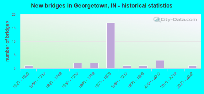
- New bridges - historical statistics
- 11920-1929
- 21950-1959
- 21960-1969
- 171970-1979
- 11980-1989
- 11990-1999
- 32000-2009
- 12020-2022

- Reconstructed bridges - Historical Statistics
- 21990-1999
- 02000-2009
- 22010-2019


- Bridge Condition - Deck
- 5.9%Excellent
- 11.8%Very good
- 29.4%Good
- 17.6%Satisfactory
- 17.6%Fair
- 17.6%Poor

- Bridge Condition - Superstructure
- 5.9%Excellent
- 11.8%Very good
- 29.4%Good
- 17.6%Satisfactory
- 29.4%Fair
- 5.9%Poor

- Bridge Condition - Substructure
- 5.9%Excellent
- 17.6%Very good
- 35.3%Good
- 29.4%Satisfactory
- 5.9%Fair
- 5.9%Poor

- Bridge Condition - Channel
- 25.0%Good
- 41.7%Satisfactory
- 33.3%Fair
Find on map >> Show street view
Structure Number: 2315, Location: 01.97 E SR 335 (Lat: 38.300339, Lng: -86.022739), Route carried "on" structure: State highway 64, Year Built: 2002, Status: Open, Structure Length: 3.26m (10.70ft), Average Daily Traffic: 10,417 (year 2004), Truck Traffic: 12%, Average Future Daily Traffic: 17,473 (year 2033), Design Load: HS 20, Features Intersected: ALSTOTT BRANCH
Minimum Vertical Clearance: 30+ m (98+ ft), Kilometerpoint: 23.915, Lanes on structure: 2, Owner: State Highway Agency, Approaching Roadway Width: 13.7m (44.9ft), Skew: 4 degrees, Material/Design: Concrete continuous, Design/Construction: Slab, Number Of Spans In Main Unit: 3, Length of Maximum Span: 12.3m (40.4ft), Curb-To-Curb Width: 13.7m (44.9ft), Out-to-Out Width: 14.6m (47.9ft)
Condition: Deck: Good, Superstructure: Good, Substructure: Good, Channel: Satisfactory, Operating Rating: 92.3 metric tons, Method Used To Determine Operating Rating: Load and Resistance Factor Rating (LRFR) rating reported by rating factor(RF) method using HL-93 loadings, Inventory Rating: 71.3 metric tons, Method Used To Determine Inventory Rating: Load and Resistance Factor Rating (LRFR) rating reported by rating factor(RF) method using HL-93 loadings, Structural Evaluation: Better than present minimum criteria, Deck Geometry: Superior to present desirable criteria, Waterway Adequacy: Equal to present desirable criteria, Approach Roadway Alignment: Equal to present desirable criteria, Designated Inspection Frequency: Every 24 months, Inspection Date: October 2020, Deck Structure Type: Concrete Cast-file-Place, Wearing Surface/Protective System: Wearing Surface: Monolithic Concrete, Deck Protection: Epoxy Coated Reinforcing
Find on map >> Show street view
Structure Number: 3432, Location: 04.15 W SR 64 (Lat: 38.270150, Lng: -85.983039), Route carried "on" structure: Alternate County highway , Year Built: 1972, Status: Open, Structure Length: 7.01m (23.00ft), Average Daily Traffic: 571 (year 2004), Truck Traffic: 10%, Average Future Daily Traffic: 954 (year 2030), Design Load: HS 20, Features Intersected: I-64 EB/WB, Facility Carried by Structure: FARNSLEY ROAD
Minimum Vertical Clearance: 30+ m (98+ ft), Kilometerpoint: 0.000, Lanes on structure: 2, Lanes under structure: 4, Owner: State Highway Agency, Approaching Roadway Width: 9.8m (32.2ft), Skew: 1 degrees, Material/Design: Steel continuous, Design/Construction: Stringer/Multi-beam, Number Of Spans In Main Unit: 2, Length of Maximum Span: 34.7m (113.8ft), Curb or Sidewalk Widths: Left: 0.1m (0.3ft), Right: 0.1m (0.3ft), Curb-To-Curb Width: 9.8m (32.2ft), Out-to-Out Width: 10.7m (35.1ft)
Condition: Deck: Fair, Superstructure: Satisfactory, Substructure: Good, Operating Rating: 55.3 metric tons, Method Used To Determine Operating Rating: Load Factor (LF), Inventory Rating: 33.1 metric tons, Method Used To Determine Inventory Rating: Load Factor (LF), Structural Evaluation: Equal to present minimum criteria, Deck Geometry: Equal to present minimum criteria, Underclear: Somewhat better than minimum adequacy, Approach Roadway Alignment: Equal to present minimum criteria, Designated Inspection Frequency: Every 24 months, Inspection Date: November 2021, Deck Structure Type: Concrete Cast-file-Place, Wearing Surface/Protective System: Wearing Surface: Monolithic Concrete
Find on map >> Show street view
Structure Number: 3433, Location: 02.55 W SR 64 (Lat: 38.276931, Lng: -85.955111), Route carried "on" structure: Alternate County highway , Year Built: 1972, Year Reconstructed: 2015, Status: Open, Structure Length: 5.55m (18.21ft), Average Daily Traffic: 500 (year 2014), Truck Traffic: 5%, Average Future Daily Traffic: 680 (year 2034), Design Load: HS 20, Features Intersected: I-64 EB, Facility Carried by Structure: BAYLOR-WISSMAN RD
Minimum Vertical Clearance: 30+ m (98+ ft), Kilometerpoint: 0.000, Lanes on structure: 2, Lanes under structure: 2, Owner: State Highway Agency, Approaching Roadway Width: 6.1m (20.0ft), Skew: 2 degrees, Material/Design: Steel continuous, Design/Construction: Stringer/Multi-beam, Number Of Spans In Main Unit: 1, Number Of Approach Spans: 2, Length of Maximum Span: 29.6m (97.1ft), Curb or Sidewalk Widths: Left: 0.1m (0.3ft), Right: 0.1m (0.3ft), Curb-To-Curb Width: 9.8m (32.2ft), Out-to-Out Width: 10.7m (35.1ft)
Condition: Deck: Good, Superstructure: Good, Substructure: Good, Operating Rating: 43.7 metric tons, Method Used To Determine Operating Rating: Load and Resistance Factor Rating (LRFR) rating reported by rating factor(RF) method using HL-93 loadings, Inventory Rating: 33.7 metric tons, Method Used To Determine Inventory Rating: Load and Resistance Factor Rating (LRFR) rating reported by rating factor(RF) method using HL-93 loadings, Structural Evaluation: Better than present minimum criteria, Deck Geometry: Meets minimum limits, Underclear: Somewhat better than minimum adequacy, Approach Roadway Alignment: Equal to present minimum criteria, Designated Inspection Frequency: Every 24 months, Other Special Inspection Frequency: Every 60 months, Inspection Date: November 2021, Other Special Inspection Date: June 2018, Deck Structure Type: Concrete Cast-file-Place, Wearing Surface/Protective System: Wearing Surface: Epoxy Overlay
Find on map >> Show street view
Structure Number: 3434, Location: 02.55 W SR 64 (Lat: 38.277839, Lng: -85.955119), Route carried "on" structure: Alternate County highway , Year Built: 1972, Year Reconstructed: 2015, Status: Open, Structure Length: 5.55m (18.21ft), Average Daily Traffic: 500 (year 2014), Truck Traffic: 5%, Average Future Daily Traffic: 680 (year 2034), Design Load: HS 20, Features Intersected: I-64 WB, Facility Carried by Structure: BAYLOR-WISSMAN RD
Minimum Vertical Clearance: 30+ m (98+ ft), Kilometerpoint: 0.000, Lanes on structure: 2, Lanes under structure: 2, Owner: State Highway Agency, Approaching Roadway Width: 6.1m (20.0ft), Skew: 2 degrees, Material/Design: Steel continuous, Design/Construction: Stringer/Multi-beam, Number Of Spans In Main Unit: 1, Number Of Approach Spans: 2, Length of Maximum Span: 29.6m (97.1ft), Curb or Sidewalk Widths: Left: 0.1m (0.3ft), Right: 0.1m (0.3ft), Curb-To-Curb Width: 9.8m (32.2ft), Out-to-Out Width: 10.7m (35.1ft)
Condition: Deck: Good, Superstructure: Good, Substructure: Good, Operating Rating: 43.1 metric tons, Method Used To Determine Operating Rating: Load and Resistance Factor Rating (LRFR) rating reported by rating factor(RF) method using HL-93 loadings, Inventory Rating: 33.4 metric tons, Method Used To Determine Inventory Rating: Load and Resistance Factor Rating (LRFR) rating reported by rating factor(RF) method using HL-93 loadings, Structural Evaluation: Better than present minimum criteria, Deck Geometry: Meets minimum limits, Underclear: Somewhat better than minimum adequacy, Approach Roadway Alignment: Equal to present minimum criteria, Designated Inspection Frequency: Every 24 months, Other Special Inspection Frequency: Every 60 months, Inspection Date: November 2021, Other Special Inspection Date: June 2018, Deck Structure Type: Concrete Cast-file-Place, Wearing Surface/Protective System: Wearing Surface: Epoxy Overlay
Find on map >> Show street view
Structure Number: 3436, Location: 00.40 W SR 64 (Lat: 38.283431, Lng: -85.918381), Route carried "on" structure: Interstate 64, Year Built: 1974, Year Reconstructed: 1995, Status: Open, Structure Length: 3.66m (12.01ft), Average Daily Traffic: 17,228 (year 2004), Truck Traffic: 10%, Average Future Daily Traffic: 34,089 (year 2031), Design Load: HS 20+Mod, Features Intersected: YENOWINE ROAD
Minimum Vertical Clearance: 30+ m (98+ ft), Kilometerpoint: 188.229, Lanes on structure: 2, Lanes under structure: 2, Base Highway Network: Yes (, Subroute: 1), Owner: State Highway Agency, Approaching Roadway Width: 12.8m (42.0ft), Skew: 2 degrees, Material/Design: Concrete continuous, Design/Construction: Slab, Number Of Spans In Main Unit: 3, Length of Maximum Span: 14.3m (46.9ft), Curb-To-Curb Width: 12.0m (39.4ft), Out-to-Out Width: 13.0m (42.7ft)
Condition: Deck: Satisfactory, Superstructure: Satisfactory, Substructure: Satisfactory, Operating Rating: 39.5 metric tons, Method Used To Determine Operating Rating: Load and Resistance Factor Rating (LRFR) rating reported by rating factor(RF) method using HL-93 loadings, Inventory Rating: 30.5 metric tons, Method Used To Determine Inventory Rating: Load and Resistance Factor Rating (LRFR) rating reported by rating factor(RF) method using HL-93 loadings, Structural Evaluation: Equal to present minimum criteria, Deck Geometry: Equal to present minimum criteria, Underclear: Somewhat better than minimum adequacy, Approach Roadway Alignment: Equal to present desirable criteria, Designated Inspection Frequency: Every 24 months, Inspection Date: November 2021, Deck Structure Type: Concrete Cast-file-Place, Wearing Surface/Protective System: Wearing Surface: Latex Concrete
Find on map >> Show street view
Structure Number: 3438, Location: 01.63 W US 150 (Lat: 38.287369, Lng: -85.912000), Route carried "on" structure: Interstate 64, Year Built: 1974, Year Reconstructed: 1995, Status: Open, Structure Length: 5.82m (19.09ft), Average Daily Traffic: 26,573 (year 2004), Truck Traffic: 10%, Average Future Daily Traffic: 51,548 (year 2031), Design Load: HS 20+Mod, Features Intersected: SR 62/SR 64 EB/WB
Minimum Vertical Clearance: 30+ m (98+ ft), Kilometerpoint: 188.873, Lanes on structure: 2, Lanes under structure: 5, Base Highway Network: Yes (, Subroute: 1), Owner: State Highway Agency, Approaching Roadway Width: 12.8m (42.0ft), Material/Design: Steel continuous, Design/Construction: Stringer/Multi-beam, Number Of Spans In Main Unit: 1, Number Of Approach Spans: 2, Length of Maximum Span: 32.6m (107.0ft), Curb-To-Curb Width: 12.2m (40.0ft), Out-to-Out Width: 13.1m (43.0ft)
Condition: Deck: Good, Superstructure: Fair, Substructure: Good, Operating Rating: 41.8 metric tons, Method Used To Determine Operating Rating: Load and Resistance Factor Rating (LRFR) rating reported by rating factor(RF) method using HL-93 loadings, Inventory Rating: 32.1 metric tons, Method Used To Determine Inventory Rating: Load and Resistance Factor Rating (LRFR) rating reported by rating factor(RF) method using HL-93 loadings, Structural Evaluation: Somewhat better than minimum adequacy, Deck Geometry: Better than present minimum criteria, Underclear: Equal to present minimum criteria, Approach Roadway Alignment: Equal to present desirable criteria, Designated Inspection Frequency: Every 24 months, Other Special Inspection Frequency: Every 60 months, Inspection Date: November 2021, Other Special Inspection Date: November 2017, Deck Structure Type: Concrete Cast-file-Place, Wearing Surface/Protective System: Wearing Surface: Latex Concrete
Find on map >> Show street view
Structure Number: 47802, Location: 00.23 E JUNIPER RD (Lat: 41.716389, Lng: -86.231339), Route carried "on" structure: Interstate 90, Year Built: 1957, Status: Open, Structure Length: 1.02m (3.35ft), Average Daily Traffic: 28,480 (year 2004), Truck Traffic: 5%, Average Future Daily Traffic: 56,734 (year 2030), Design Load: HS 20, Features Intersected: JUDAY CREEK
Minimum Vertical Clearance: 30+ m (98+ ft), Kilometerpoint: 125.416, Lanes on structure: 4, Base Highway Network: Yes (, Subroute: 1), Toll: On toll road, Owner: State Toll Authority, Approaching Roadway Width: 37.8m (124.0ft), Skew: 16 degrees, Material/Design: Concrete, Design/Construction: Culvert, Number Of Spans In Main Unit: 1, Length of Maximum Span: 10.2m (33.5ft)
Condition: Channel: Good, Culverts: Fair, Operating Rating: 45.0 metric tons, Method Used To Determine Operating Rating: Load and Resistance Factor Rating (LRFR) rating reported by rating factor(RF) method using HL-93 loadings, Inventory Rating: 34.7 metric tons, Method Used To Determine Inventory Rating: Load and Resistance Factor Rating (LRFR) rating reported by rating factor(RF) method using HL-93 loadings, Structural Evaluation: Somewhat better than minimum adequacy, Waterway Adequacy: Better than present minimum criteria, Approach Roadway Alignment: Equal to present desirable criteria, Designated Inspection Frequency: Every 24 months, Inspection Date: July 2021
Find on map >> Show street view
Structure Number: 76622, Location: 04.32 W I-64 (Lat: 38.296500, Lng: -85.985289), Route carried "on" structure: State highway 64, Year Built: 2008, Status: Open, Structure Length: 3.96m (12.99ft), Average Daily Traffic: 17,171 (year 1998), Truck Traffic: 2%, Average Future Daily Traffic: 32,199 (year 2030), Design Load: HS 20+Mod, Features Intersected: GEORGETOWN CREEK
Minimum Vertical Clearance: 30+ m (98+ ft), Kilometerpoint: 0.917, Lanes on structure: 2, Owner: State Highway Agency, Approaching Roadway Width: 12.1m (39.7ft), Skew: 1 degrees, Material/Design: Prestressed concrete continuous, Design/Construction: Box Beam or Girders - Single/Spread, Number Of Spans In Main Unit: 3, Length of Maximum Span: 13.1m (43.0ft), Curb-To-Curb Width: 11.2m (36.7ft), Out-to-Out Width: 12.1m (39.7ft)
Condition: Deck: Good, Superstructure: Good, Substructure: Very good, Channel: Good, Operating Rating: 60.9 metric tons, Method Used To Determine Operating Rating: Load Factor (LF), Inventory Rating: 36.5 metric tons, Method Used To Determine Inventory Rating: Load Factor (LF), Structural Evaluation: Better than present minimum criteria, Deck Geometry: Meets minimum limits, Waterway Adequacy: Better than present minimum criteria, Approach Roadway Alignment: Equal to present desirable criteria, Designated Inspection Frequency: Every 24 months, Inspection Date: October 2020, Deck Structure Type: Concrete Cast-file-Place, Wearing Surface/Protective System: Wearing Surface: Monolithic Concrete, Deck Protection: Epoxy Coated Reinforcing
Find on map >> Show street view
Structure Number: 2200021, Location: 00.50 S of BUTTONTWN Rd (Lat: 38.330119, Lng: -85.987428), Route carried "on" structure: Alternate County highway , Year Built: 1996, Status: Open, Structure Length: 4.27m (14.01ft), Average Daily Traffic: 444 (year 2016), Truck Traffic: 3%, Average Future Daily Traffic: 654 (year 2036), Design Load: HS 20, Features Intersected: BIG INDIAN Creek, Facility Carried by Structure: HAMBY Rd
Minimum Vertical Clearance: 30+ m (98+ ft), Kilometerpoint: 0.000, Lanes on structure: 2, Owner: County Highway Agency, Approaching Roadway Width: 6.7m (22.0ft), Skew: 3 degrees, Material/Design: Prestressed concrete continuous, Design/Construction: Stringer/Multi-beam, Number Of Spans In Main Unit: 3, Length of Maximum Span: 14.0m (45.9ft), Curb-To-Curb Width: 7.9m (25.9ft), Out-to-Out Width: 8.8m (28.9ft)
Condition: Deck: Very good, Superstructure: Very good, Substructure: Very good, Channel: Satisfactory, Operating Rating: 55.8 metric tons, Method Used To Determine Operating Rating: Load and Resistance Factor (LRFR), Inventory Rating: 28.9 metric tons, Method Used To Determine Inventory Rating: Load and Resistance Factor (LRFR), Structural Evaluation: Better than present minimum criteria, Deck Geometry: Somewhat better than minimum adequacy, Waterway Adequacy: Somewhat better than minimum adequacy, Approach Roadway Alignment: Equal to present minimum criteria, Designated Inspection Frequency: Every 48 months, Inspection Date: March 2020, Deck Structure Type: Concrete Cast-file-Place, Wearing Surface/Protective System: Wearing Surface: Monolithic Concrete, Deck Protection: Epoxy Coated Reinforcing
Find on map >> Show street view
Structure Number: 2200023, Location: 00.60 S of BAKER Rd (Lat: 38.329550, Lng: -86.006761), Route carried "on" structure: County highway , Year Built: 1929, Status: Open, Structure Length: 1.32m (4.33ft), Average Daily Traffic: 380 (year 2016), Truck Traffic: 5%, Average Future Daily Traffic: 559 (year 2036), Features Intersected: RICHLAND CREEK, Facility Carried by Structure: G'TOWN-GREENVILLE
Minimum Vertical Clearance: 30+ m (98+ ft), Kilometerpoint: 0.000, Lanes on structure: 2, Owner: County Highway Agency, Approaching Roadway Width: 6.1m (20.0ft), Skew: 1 degrees, Material/Design: Concrete continuous, Design/Construction: Slab, Number Of Spans In Main Unit: 2, Length of Maximum Span: 5.9m (19.4ft), Curb-To-Curb Width: 6.1m (20.0ft), Out-to-Out Width: 6.7m (22.0ft)
Condition: Deck: Fair, Superstructure: Fair, Substructure: Satisfactory, Channel: Fair, Operating Rating: 32.7 metric tons, Method Used To Determine Operating Rating: Field evaluation and documented engineering judgment, Inventory Rating: 32.7 metric tons, Method Used To Determine Inventory Rating: Field evaluation and documented engineering judgment, Structural Evaluation: Somewhat better than minimum adequacy, Deck Geometry: Meets minimum limits, Waterway Adequacy: Meets minimum limits, Approach Roadway Alignment: Equal to present minimum criteria, Length Of Structure Improvement: 1.98m (6.50ft), Designated Inspection Frequency: Every 24 months, Inspection Date: March 2020, Bridge Improvement Cost: $306,000, Roadway Improvement Cost: $184,000, Total Project Cost: $619,000 ( Estimate for 2020), Deck Structure Type: Concrete Cast-file-Place, Wearing Surface/Protective System: Wearing Surface: Bituminous
Find on map >> Show street view
Structure Number: 2200026, Location: 00.10 W of COOKS MILL (Lat: 38.317689, Lng: -86.001808), Route carried "on" structure: County highway , Year Built: 1972, Status: Open, Structure Length: 4.97m (16.31ft), Average Daily Traffic: 308 (year 2016), Truck Traffic: 5%, Average Future Daily Traffic: 453 (year 2036), Design Load: HS 20, Features Intersected: BIG INDIAN Creek, Facility Carried by Structure: G'TOWN-GREENVILLE
Minimum Vertical Clearance: 30+ m (98+ ft), Kilometerpoint: 0.000, Lanes on structure: 2, Owner: County Highway Agency, Approaching Roadway Width: 8.4m (27.6ft), Skew: 4 degrees, Material/Design: Steel continuous, Design/Construction: Stringer/Multi-beam, Number Of Spans In Main Unit: 3, Length of Maximum Span: 21.2m (69.6ft), Curb or Sidewalk Widths: Left: 0.3m (1.0ft), Right: 0.3m (1.0ft), Curb-To-Curb Width: 8.6m (28.2ft), Out-to-Out Width: 9.2m (30.2ft)
Condition: Deck: Poor, Superstructure: Satisfactory, Substructure: Poor, Channel: Fair, Operating Rating: 60.1 metric tons, Method Used To Determine Operating Rating: Load and Resistance Factor (LRFR), Inventory Rating: 55.8 metric tons, Method Used To Determine Inventory Rating: Load and Resistance Factor (LRFR), Structural Evaluation: Meets minimum limits, Deck Geometry: Equal to present minimum criteria, Waterway Adequacy: Equal to present minimum criteria, Approach Roadway Alignment: Equal to present minimum criteria, Length Of Structure Improvement: 4.97m (16.31ft), Designated Inspection Frequency: Every 12 months, Inspection Date: March 2021, Bridge Improvement Cost: $423,000, Roadway Improvement Cost: $184,000, Total Project Cost: $735,000 ( Estimate for 2020), Deck Structure Type: Concrete Cast-file-Place, Wearing Surface/Protective System: Wearing Surface: Monolithic Concrete
Find on map >> Show street view
Structure Number: 2200027, Location: 00.10 S OF BYRN'VL (Lat: 38.324039, Lng: -86.011878), Route carried "on" structure: County highway , Year Built: 1964, Status: Open, Structure Length: 1.16m (3.81ft), Average Daily Traffic: 308 (year 2016), Truck Traffic: 5%, Average Future Daily Traffic: 453 (year 2036), Features Intersected: RICHLAND CREEK, Facility Carried by Structure: G'TOWN-GREENVILLE
Minimum Vertical Clearance: 30+ m (98+ ft), Kilometerpoint: 0.000, Lanes on structure: 2, Owner: County Highway Agency, Approaching Roadway Width: 6.4m (21.0ft), Material/Design: Concrete, Design/Construction: Channel Beam, Number Of Spans In Main Unit: 1, Length of Maximum Span: 10.7m (35.1ft), Curb-To-Curb Width: 6.8m (22.3ft), Out-to-Out Width: 6.9m (22.6ft)
Condition: Deck: Satisfactory, Superstructure: Fair, Substructure: Satisfactory, Channel: Satisfactory, Operating Rating: 32.7 metric tons, Method Used To Determine Operating Rating: Field evaluation and documented engineering judgment, Inventory Rating: 32.7 metric tons, Method Used To Determine Inventory Rating: Field evaluation and documented engineering judgment, Structural Evaluation: Somewhat better than minimum adequacy, Deck Geometry: Meets minimum limits, Waterway Adequacy: Somewhat better than minimum adequacy, Approach Roadway Alignment: Equal to present minimum criteria, Designated Inspection Frequency: Every 24 months, Inspection Date: March 2020, Deck Structure Type: Concrete Precast Panels, Wearing Surface/Protective System: Wearing Surface: Bituminous
Find on map >> Show street view
Structure Number: 220003, Location: 00.10 N OF DUFFY RD (Lat: 38.310050, Lng: -85.910378), Route carried "on" structure: Alternate County highway , Year Built: 1968, Status: Open, Structure Length: 1.83m (6.00ft), Average Daily Traffic: 244 (year 2016), Truck Traffic: 3%, Average Future Daily Traffic: 359 (year 2036), Design Load: HS 20, Features Intersected: LITTLE INDIAN CREEK, Facility Carried by Structure: N LUTHER RD
Minimum Vertical Clearance: 30+ m (98+ ft), Kilometerpoint: 0.000, Lanes on structure: 2, Owner: County Highway Agency, Approaching Roadway Width: 6.1m (20.0ft), Material/Design: Prestressed concrete, Design/Construction: Box Beam or Girders - Multiple, Number Of Spans In Main Unit: 1, Length of Maximum Span: 17.4m (57.1ft), Curb or Sidewalk Widths: Left: 0.3m (1.0ft), Right: 0.3m (1.0ft), Curb-To-Curb Width: 7.5m (24.6ft), Out-to-Out Width: 8.1m (26.6ft)
Condition: Deck: Poor, Superstructure: Poor, Substructure: Satisfactory, Channel: Satisfactory, Operating Rating: 45.3 metric tons, Method Used To Determine Operating Rating: Load and Resistance Factor (LRFR), Inventory Rating: 29.7 metric tons, Method Used To Determine Inventory Rating: Load and Resistance Factor (LRFR), Structural Evaluation: Meets minimum limits, Deck Geometry: Somewhat better than minimum adequacy, Waterway Adequacy: Equal to present desirable criteria, Approach Roadway Alignment: Equal to present desirable criteria, Length Of Structure Improvement: 1.83m (6.00ft), Designated Inspection Frequency: Every 12 months, Inspection Date: March 2021, Bridge Improvement Cost: $137,000, Roadway Improvement Cost: $184,000, Total Project Cost: $389,000 ( Estimate for 2020), Deck Structure Type: Concrete Precast Panels, Wearing Surface/Protective System: Wearing Surface: Bituminous
Find on map >> Show street view
Structure Number: 2200032, Location: 00.10 W OF GRNVILLE/GRTWN (Lat: 38.309050, Lng: -85.997803), Route carried "on" structure: Alternate County highway , Year Built: 1984, Status: Open, Structure Length: 1.92m (6.30ft), Average Daily Traffic: 193 (year 2016), Truck Traffic: 3%, Average Future Daily Traffic: 274 (year 2036), Design Load: HS 20, Features Intersected: GEORGETOWN CREEK, Facility Carried by Structure: MALINEE-OTT RD
Minimum Vertical Clearance: 30+ m (98+ ft), Kilometerpoint: 0.000, Lanes on structure: 2, Owner: County Highway Agency, Approaching Roadway Width: 6.4m (21.0ft), Skew: 3 degrees, Material/Design: Prestressed concrete, Design/Construction: Box Beam or Girders - Multiple, Number Of Spans In Main Unit: 1, Length of Maximum Span: 17.7m (58.1ft), Curb-To-Curb Width: 7.3m (24.0ft), Out-to-Out Width: 7.4m (24.3ft)
Condition: Deck: Satisfactory, Superstructure: Good, Substructure: Good, Channel: Fair, Operating Rating: 47.2 metric tons, Method Used To Determine Operating Rating: Load and Resistance Factor (LRFR), Inventory Rating: 34.2 metric tons, Method Used To Determine Inventory Rating: Load and Resistance Factor (LRFR), Structural Evaluation: Better than present minimum criteria, Deck Geometry: Somewhat better than minimum adequacy, Waterway Adequacy: Equal to present minimum criteria, Approach Roadway Alignment: Equal to present minimum criteria, Designated Inspection Frequency: Every 24 months, Inspection Date: March 2020, Deck Structure Type: Concrete Precast Panels, Wearing Surface/Protective System: Wearing Surface: Monolithic Concrete
Find on map >> Show street view
Structure Number: 2200034, Location: 00.10 S OF US 64 (Lat: 38.293389, Lng: -85.980256), Route carried "on" structure: City street , Year Built: 1976, Status: Open, Structure Length: 3.95m (12.96ft), Average Daily Traffic: 1,301 (year 2016), Truck Traffic: 5%, Average Future Daily Traffic: 1,916 (year 2036), Design Load: HS 20, Features Intersected: GEORGETOWN CREEK, Facility Carried by Structure: G'TOWN-LANESVILLE
Minimum Vertical Clearance: 30+ m (98+ ft), Kilometerpoint: 0.000, Lanes on structure: 2, Owner: County Highway Agency, Approaching Roadway Width: 7.9m (25.9ft), Material/Design: Steel, Design/Construction: Stringer/Multi-beam, Number Of Spans In Main Unit: 3, Length of Maximum Span: 13.1m (43.0ft), Curb-To-Curb Width: 10.0m (32.8ft), Out-to-Out Width: 10.7m (35.1ft)
Condition: Deck: Poor, Superstructure: Fair, Substructure: Satisfactory, Channel: Satisfactory, Operating Rating: 57.4 metric tons, Method Used To Determine Operating Rating: Load and Resistance Factor (LRFR), Inventory Rating: 53.3 metric tons, Method Used To Determine Inventory Rating: Load and Resistance Factor (LRFR), Structural Evaluation: Somewhat better than minimum adequacy, Deck Geometry: Somewhat better than minimum adequacy, Waterway Adequacy: Equal to present minimum criteria, Approach Roadway Alignment: Equal to present minimum criteria, Length Of Structure Improvement: 3.96m (12.99ft), Designated Inspection Frequency: Every 12 months, Inspection Date: March 2021, Bridge Improvement Cost: $336,000, Roadway Improvement Cost: $184,000, Total Project Cost: $630,000 ( Estimate for 2020), Deck Structure Type: Concrete Cast-file-Place, Wearing Surface/Protective System: Wearing Surface: Monolithic Concrete
Find on map >> Show street view
Structure Number: 2200036, Location: 00.10 S OF US 64 (Lat: 38.292811, Lng: -85.972244), Route carried "on" structure: Alternate City street , Year Built: 2002, Status: Open, Structure Length: 2.86m (9.38ft), Average Daily Traffic: 549 (year 2016), Truck Traffic: 5%, Average Future Daily Traffic: 809 (year 2036), Design Load: HS 20, Features Intersected: GEORGETOWN CREEK, Facility Carried by Structure: WALTS RD
Minimum Vertical Clearance: 30+ m (98+ ft), Kilometerpoint: 0.000, Lanes on structure: 2, Owner: County Highway Agency, Approaching Roadway Width: 7.3m (24.0ft), Material/Design: Concrete continuous, Design/Construction: Slab, Number Of Spans In Main Unit: 3, Length of Maximum Span: 11.3m (37.1ft), Curb-To-Curb Width: 7.8m (25.6ft), Out-to-Out Width: 8.8m (28.9ft)
Condition: Deck: Very good, Superstructure: Very good, Substructure: Very good, Channel: Good, Operating Rating: 60.6 metric tons, Method Used To Determine Operating Rating: Load and Resistance Factor (LRFR), Inventory Rating: 48.3 metric tons, Method Used To Determine Inventory Rating: Load and Resistance Factor (LRFR), Structural Evaluation: Equal to present desirable criteria, Deck Geometry: Meets minimum limits, Waterway Adequacy: Better than present minimum criteria, Approach Roadway Alignment: Equal to present minimum criteria, Designated Inspection Frequency: Every 48 months, Inspection Date: March 2020, Deck Structure Type: Concrete Cast-file-Place, Wearing Surface/Protective System: Wearing Surface: Monolithic Concrete, Deck Protection: Epoxy Coated Reinforcing
Find on map >> Show street view
Structure Number: 2200037, Location: 00.10 S OF US 64 (Lat: 38.295381, Lng: -85.957528), Route carried "on" structure: Alternate City street , Year Built: 1950, Status: Open, Structure Length: 1.35m (4.43ft), Average Daily Traffic: 939 (year 2016), Truck Traffic: 3%, Average Future Daily Traffic: 1,383 (year 2036), Features Intersected: GEORGETOWN CREEK, Facility Carried by Structure: BAYLOR-WISSMAN RD
Minimum Vertical Clearance: 30+ m (98+ ft), Kilometerpoint: 0.000, Lanes on structure: 1, Owner: County Highway Agency, Approaching Roadway Width: 5.2m (17.1ft), Material/Design: Concrete, Design/Construction: Slab, Number Of Spans In Main Unit: 2, Length of Maximum Span: 5.9m (19.4ft), Curb-To-Curb Width: 5.1m (16.7ft), Out-to-Out Width: 5.9m (19.4ft)
Condition: Deck: Fair, Superstructure: Fair, Substructure: Fair, Channel: Fair, Operating Rating: 32.7 metric tons, Method Used To Determine Operating Rating: Field evaluation and documented engineering judgment, Inventory Rating: 32.7 metric tons, Method Used To Determine Inventory Rating: Field evaluation and documented engineering judgment, Structural Evaluation: Somewhat better than minimum adequacy, Deck Geometry: High priority of replacement, Waterway Adequacy: Equal to present desirable criteria, Approach Roadway Alignment: Equal to present minimum criteria, Length Of Structure Improvement: 2.01m (6.59ft), Designated Inspection Frequency: Every 24 months, Inspection Date: March 2020, Bridge Improvement Cost: $274,000, Roadway Improvement Cost: $184,000, Total Project Cost: $578,000 ( Estimate for 2020), Deck Structure Type: Concrete Cast-file-Place, Wearing Surface/Protective System: Wearing Surface: Bituminous
Find on map >> Show street view
Structure Number: 3100123, Location: 0.68 S OLD LANESVILLE RD (Lat: 38.327689, Lng: -86.009881), Route carried "on" structure: Alternate County highway , Year Built: 2020, Status: Open, Structure Length: 2.44m (8.01ft), Average Daily Traffic: 5,330 (year 2020), Truck Traffic: 8%, Average Future Daily Traffic: 7,620 (year 2040), Design Load: HL 93, Features Intersected: N&W RR, Facility Carried by Structure: PETE SCHNICKEL WAY
Minimum Vertical Clearance: 30+ m (98+ ft), Kilometerpoint: 0.000, Lanes on structure: 2, Owner: County Highway Agency, Approaching Roadway Width: 13.1m (43.0ft), Material/Design: Prestressed concrete, Design/Construction: Stringer/Multi-beam, Number Of Spans In Main Unit: 1, Length of Maximum Span: 22.9m (75.1ft), Curb-To-Curb Width: 13.2m (43.3ft), Out-to-Out Width: 14.1m (46.3ft)
Condition: Deck: Excellent, Superstructure: Excellent, Substructure: Excellent, Operating Rating: 40.8 metric tons, Method Used To Determine Operating Rating: Field evaluation and documented engineering judgment, Inventory Rating: 32.7 metric tons, Method Used To Determine Inventory Rating: Field evaluation and documented engineering judgment, Structural Evaluation: Superior to present desirable criteria, Deck Geometry: Somewhat better than minimum adequacy, Underclear: Superior to present desirable criteria, Approach Roadway Alignment: Equal to present desirable criteria, Designated Inspection Frequency: Every 24 months, Inspection Date: Febuary 2021, Deck Structure Type: Concrete Cast-file-Place, Wearing Surface/Protective System: Wearing Surface: Latex Concrete
Find on map >> Show street view
Structure Number: 3432, Location: 04.15 W SR-64 (Lat: 38.270150, Lng: -85.983039), Route carried "under" structure: Interstate 64, Year Built: 1972, Structure Length: 0. m, Average Daily Traffic: 17,228 (year 2004), Truck Traffic: 10%, Features Intersected: I-64 EBL, Facility Carried by Structure: FARNSLEY ROAD
Minimum Vertical Clearance: 4.83m (15.85ft), Kilometerpoint: 182.194, Lanes on structure: 2, Lanes under structure: 4, Material/Design: Steel continuous, Design/Construction: Stringer/Multi-beam, Length of Maximum Span: 34.7m (113.8ft)
Find on map >> Show street view
Structure Number: 3432, Location: 04.15 W SR-64 (Lat: 38.270150, Lng: -85.983039), Route carried "under" structure: Interstate 64, Year Built: 1972, Structure Length: 0. m, Average Daily Traffic: 17,228 (year 2004), Truck Traffic: 10%, Features Intersected: I-64 WBL, Facility Carried by Structure: FARNSLEY ROAD
Minimum Vertical Clearance: 4.85m (15.91ft), Kilometerpoint: 182.194, Lanes on structure: 2, Lanes under structure: 4, Material/Design: Steel continuous, Design/Construction: Stringer/Multi-beam, Length of Maximum Span: 34.7m (113.8ft)
Find on map >> Show street view
Structure Number: 3433, Location: 02.55 W SR-64 (Lat: 38.276969, Lng: -85.955153), Route carried "under" structure: Interstate 64, Year Built: 1972, Structure Length: 0. m, Average Daily Traffic: 34,450 (year 2004), Truck Traffic: 10%, Features Intersected: I-64 EBL, Facility Carried by Structure: BAYLOR-WISSMAN RD
Minimum Vertical Clearance: 5.03m (16.50ft), Kilometerpoint: 184.769, Lanes on structure: 2, Lanes under structure: 2, Material/Design: Steel continuous, Design/Construction: Stringer/Multi-beam, Length of Maximum Span: 29.6m (97.1ft)
Find on map >> Show street view
Structure Number: 3434, Location: 02.55 W SR-64 (Lat: 38.277839, Lng: -85.955125), Route carried "under" structure: Interstate 64, Year Built: 1972, Structure Length: 0. m, Average Daily Traffic: 17,228 (year 2004), Truck Traffic: 10%, Features Intersected: I-64 WBL, Facility Carried by Structure: BAYLOR-WISSMAN RD
Minimum Vertical Clearance: 5.03m (16.50ft), Kilometerpoint: 184.769, Lanes on structure: 2, Lanes under structure: 2, Material/Design: Steel continuous, Design/Construction: Stringer/Multi-beam, Length of Maximum Span: 29.6m (97.1ft)
Find on map >> Show street view
Structure Number: 3435, Location: 00.40 W SR-64 (Lat: 38.283189, Lng: -85.918372), Route carried "under" structure: County highway , Year Built: 1974, Structure Length: 0. m, Average Daily Traffic: 571 (year 2004), Truck Traffic: 5%, Features Intersected: YENOWINE ROAD, Facility Carried by Structure: I-64 EB
Minimum Vertical Clearance: 4.44m (14.57ft), Kilometerpoint: 0.000, Lanes on structure: 3, Lanes under structure: 2, Material/Design: Concrete continuous, Design/Construction: Slab, Length of Maximum Span: 14.3m (46.9ft)
Find on map >> Show street view
Structure Number: 3436, Location: 00.40 W SR-64 (Lat: 38.283431, Lng: -85.918381), Route carried "under" structure: County highway , Year Built: 1974, Structure Length: 0. m, Average Daily Traffic: 571 (year 2004), Truck Traffic: 5%, Features Intersected: YENOWINE ROAD, Facility Carried by Structure: I-64 WB
Minimum Vertical Clearance: 4.52m (14.83ft), Kilometerpoint: 0.000, Lanes on structure: 2, Lanes under structure: 2, Material/Design: Concrete continuous, Design/Construction: Slab, Length of Maximum Span: 14.3m (46.9ft)
Find on map >> Show street view
Structure Number: 3437, Location: 01.63 W US-150 (Lat: 38.287239, Lng: -85.911811), Route carried "under" structure: State highway 62, Year Built: 1974, Structure Length: 0. m, Average Daily Traffic: 5,680 (year 2004), Truck Traffic: 10%, Features Intersected: SR-62/SR-64 EBL, Facility Carried by Structure: I-64 EB
Minimum Vertical Clearance: 5.13m (16.83ft), Kilometerpoint: 6.968, Lanes on structure: 2, Lanes under structure: 5, Material/Design: Steel continuous, Design/Construction: Stringer/Multi-beam, Length of Maximum Span: 32.6m (107.0ft)
Find on map >> Show street view
Structure Number: 3437, Location: 01.63 W US-150 (Lat: 38.287239, Lng: -85.911811), Route carried "under" structure: State highway 62, Year Built: 1974, Structure Length: 0. m, Average Daily Traffic: 5,680 (year 2004), Truck Traffic: 10%, Features Intersected: SR-62/SR-64 WBL, Facility Carried by Structure: I-64 EB
Minimum Vertical Clearance: 5.08m (16.67ft), Kilometerpoint: 6.968, Lanes on structure: 2, Lanes under structure: 5, Material/Design: Steel continuous, Design/Construction: Stringer/Multi-beam, Length of Maximum Span: 32.6m (107.0ft)
Find on map >> Show street view
Structure Number: 3438, Location: 01.63 W US-150 (Lat: 38.287369, Lng: -85.912003), Route carried "under" structure: State highway 62, Year Built: 1974, Structure Length: 0. m, Average Daily Traffic: 5,680 (year 2004), Truck Traffic: 10%, Features Intersected: SR-62/SR-64 EBL, Facility Carried by Structure: I-64 WB
Minimum Vertical Clearance: 5.54m (18.18ft), Kilometerpoint: 6.985, Lanes on structure: 2, Lanes under structure: 5, Material/Design: Steel continuous, Design/Construction: Stringer/Multi-beam, Length of Maximum Span: 32.6m (107.0ft)
Find on map >> Show street view
Structure Number: 3438, Location: 01.63 W US-150 (Lat: 38.287369, Lng: -85.912003), Route carried "under" structure: State highway 62, Year Built: 1974, Structure Length: 0. m, Average Daily Traffic: 5,680 (year 2004), Truck Traffic: 10%, Features Intersected: SR-62/SR-64 WBL, Facility Carried by Structure: I-64 WB
Minimum Vertical Clearance: 5.51m (18.08ft), Kilometerpoint: 6.985, Lanes on structure: 2, Lanes under structure: 5, Material/Design: Steel continuous, Design/Construction: Stringer/Multi-beam, Length of Maximum Span: 32.6m (107.0ft)