Bridge Statistics for Gibsonton, Florida (FL)
Condition, Traffic, Stress, Structural Evaluation, Project Costs
- National Bridge Inventory (NBI) Statistics
- 10Number of bridges
- 351ft / 107mTotal length
- $239,000Total costs
- 219,931Total average daily traffic
- 22,333Total average daily truck traffic
- National Bridge Inventory (NBI) Registered Bridges for Gibsonton
- No street view available for this location
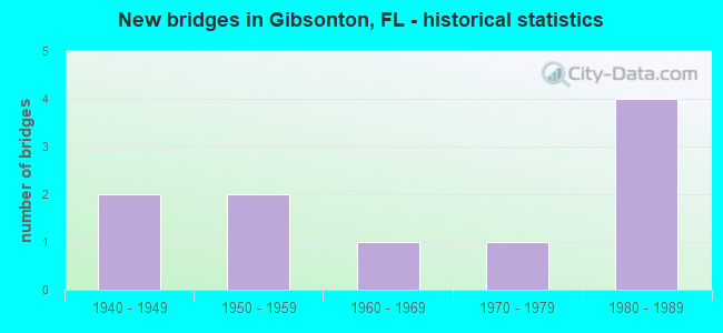
- New bridges - historical statistics
- 21940-1949
- 21950-1959
- 11960-1969
- 11970-1979
- 41980-1989

- Reconstructed bridges - Historical Statistics
- 11950-1959
- 01960-1969
- 01970-1979
- 11980-1989


- Bridge Condition - Deck
- 42.9%Good
- 57.1%Satisfactory

- Bridge Condition - Superstructure
- 42.9%Good
- 28.6%Satisfactory
- 14.3%Fair
- 14.3%Poor

- Bridge Condition - Substructure
- 28.6%Good
- 57.1%Satisfactory
- 14.3%Fair

- Bridge Condition - Channel
- 87.5%Good
- 12.5%Satisfactory

- Bridge Condition - Culverts
- 50.0%Good
- 50.0%Satisfactory
Find on map >> Show street view
Structure Number: 100044, Location: 1.5 MI SOUTH ALAFIA RIVER (Lat: 27.837981, Lng: -82.381850), Route carried "on" structure: US 41, Year Built: 1960, Year Reconstructed: 1986, Status: Open, Structure Length: 6.18m (20.28ft), Average Daily Traffic: 17,500 (year 2021), Truck Traffic: 9%, Average Future Daily Traffic: 30,362 (year 2041), Design Load: HS 20, Features Intersected: BULLFROG CREEK
Minimum Vertical Clearance: 30+ m (98+ ft), Kilometerpoint: 28.006, Lanes on structure: 2, Base Highway Network: Yes, Owner: State Highway Agency, Approaching Roadway Width: 7.6m (24.9ft), Material/Design: Concrete, Design/Construction: Slab, Number Of Spans In Main Unit: 9, Length of Maximum Span: 7.0m (23.0ft), Curb or Sidewalk Widths: Left: 1.1m (3.6ft), Right: 0.0m, Curb-To-Curb Width: 8.6m (28.2ft), Out-to-Out Width: 11.1m (36.4ft)
Condition: Deck: Satisfactory, Superstructure: Satisfactory, Substructure: Satisfactory, Channel: Good, Operating Rating: 62.6 metric tons, Method Used To Determine Operating Rating: Load Factor (LF), Inventory Rating: 37.2 metric tons, Method Used To Determine Inventory Rating: Load Factor (LF), Structural Evaluation: Equal to present minimum criteria, Deck Geometry: High priority of corrective action, Waterway Adequacy: Equal to present desirable criteria, Approach Roadway Alignment: Equal to present desirable criteria, Length Of Structure Improvement: 6.20m (20.34ft), Designated Inspection Frequency: Every 24 months, Underwater Inspection Frequency: Every 24 months, Inspection Date: March 2021, Underwater Inspection Date: Febuary 2021, Bridge Improvement Cost: $217,000, Roadway Improvement Cost: $22,000, Total Project Cost: $239,000, Deck Structure Type: Concrete Cast-file-Place
Find on map >> Show street view
Structure Number: 100045, Location: 7.5 MILES SOUTH OF SR-60 (Lat: 27.859508, Lng: -82.383700), Route carried "on" structure: US 41, Year Built: 1959, Status: Open, Structure Length: 37.06m (121.59ft), Average Daily Traffic: 17,500 (year 2021), Truck Traffic: 9%, Average Future Daily Traffic: 30,362 (year 2041), Design Load: H 20, Features Intersected: ALAFIA RIVER
Minimum Vertical Clearance: 30+ m (98+ ft), Kilometerpoint: 30.252, Lanes on structure: 2, Base Highway Network: Yes, Owner: State Highway Agency, Approaching Roadway Width: 8.7m (28.5ft), Navigation Control: Yes ( Vertical Clearance: 9.1m (29.9ft), Horizontal Clearance: 14.9m (48.9ft)), Material/Design: Prestressed concrete, Design/Construction: Stringer/Multi-beam, Number Of Spans In Main Unit: 24, Length of Maximum Span: 24.1m (79.1ft), Curb or Sidewalk Widths: Left: 1.0m (3.3ft), Right: 0.0m, Curb-To-Curb Width: 8.7m (28.5ft), Out-to-Out Width: 9.8m (32.2ft)
Condition: Deck: Satisfactory, Superstructure: Fair, Substructure: Satisfactory, Channel: Good, Operating Rating: 50.3 metric tons, Method Used To Determine Operating Rating: Load Factor (LF), Inventory Rating: 30.0 metric tons, Method Used To Determine Inventory Rating: Load Factor (LF), Structural Evaluation: Somewhat better than minimum adequacy, Deck Geometry: High priority of corrective action, Waterway Adequacy: Equal to present desirable criteria, Approach Roadway Alignment: Equal to present desirable criteria, Designated Inspection Frequency: Every 24 months, Underwater Inspection Frequency: Every 24 months, Inspection Date: March 2021, Underwater Inspection Date: Febuary 2021, Deck Structure Type: Concrete Cast-file-Place, Wearing Surface/Protective System: Wearing Surface: Integral Concrete
Find on map >> Show street view
Structure Number: 100046, Location: 3.3MI SOUTH OF SR-676 (Lat: 27.877461, Lng: -82.392486), Route carried "on" structure: US 41, Year Built: 1943, Year Reconstructed: 1959, Status: Open, Structure Length: 1.03m (3.38ft), Average Daily Traffic: 30,000 (year 2021), Truck Traffic: 10%, Average Future Daily Traffic: 52,050 (year 2041), Design Load: H 15, Features Intersected: ARCHIE CREEK
Minimum Vertical Clearance: 30+ m (98+ ft), Kilometerpoint: 32.617, Lanes on structure: 4, Base Highway Network: Yes (Inventory Route: 100600, Subroute: 1), Owner: State Highway Agency, Approaching Roadway Width: 19.8m (65.0ft), Skew: 12 degrees, Material/Design: Concrete, Design/Construction: Culvert, Number Of Spans In Main Unit: 3, Length of Maximum Span: 3.6m (11.8ft)
Condition: Channel: Good, Culverts: Satisfactory, Operating Rating: 87.1 metric tons, Method Used To Determine Operating Rating: Load Factor (LF), Inventory Rating: 52.3 metric tons, Method Used To Determine Inventory Rating: Load Factor (LF), Structural Evaluation: Equal to present minimum criteria, Waterway Adequacy: Equal to present desirable criteria, Approach Roadway Alignment: Equal to present desirable criteria, Designated Inspection Frequency: Every 24 months, Inspection Date: March 2021
Find on map >> Show street view
Structure Number: 100106, Location: 1.5 MI S OF ALAFIA RIVER (Lat: 27.838031, Lng: -82.381650), Route carried "on" structure: US 41, Year Built: 1945, Status: Open, Structure Length: 6.43m (21.10ft), Average Daily Traffic: 17,500 (year 2021), Truck Traffic: 9%, Average Future Daily Traffic: 30,362 (year 2041), Design Load: HS 20, Features Intersected: BULLFROG CREEK
Minimum Vertical Clearance: 30+ m (98+ ft), Kilometerpoint: 28.015, Lanes on structure: 2, Base Highway Network: Yes, Owner: State Highway Agency, Approaching Roadway Width: 8.7m (28.5ft), Material/Design: Concrete, Design/Construction: Slab, Number Of Spans In Main Unit: 14, Length of Maximum Span: 4.4m (14.4ft), Curb or Sidewalk Widths: Left: 0.3m (1.0ft), Right: 1.2m (3.9ft), Curb-To-Curb Width: 7.4m (24.3ft), Out-to-Out Width: 9.7m (31.8ft)
Condition: Deck: Good, Superstructure: Good, Substructure: Satisfactory, Channel: Good, Operating Rating: 43.5 metric tons, Method Used To Determine Operating Rating: Load Factor (LF), Inventory Rating: 26.3 metric tons, Method Used To Determine Inventory Rating: Load Factor (LF), Structural Evaluation: Equal to present minimum criteria, Deck Geometry: High priority of replacement, Waterway Adequacy: Equal to present desirable criteria, Approach Roadway Alignment: Equal to present desirable criteria, Designated Inspection Frequency: Every 24 months, Underwater Inspection Frequency: Every 24 months, Inspection Date: March 2021, Underwater Inspection Date: Febuary 2021, Deck Structure Type: Concrete Cast-file-Place, Wearing Surface/Protective System: Wearing Surface: Bituminous
Find on map >> Show street view
Structure Number: 100107, Location: 7.5 MILES S OF SR-60 (Lat: 27.859656, Lng: -82.383600), Route carried "on" structure: US 41, Year Built: 1952, Status: Open, Structure Length: 37.06m (121.59ft), Average Daily Traffic: 17,500 (year 2021), Truck Traffic: 9%, Average Future Daily Traffic: 30,362 (year 2041), Design Load: H 20, Features Intersected: ALAFIA RIVER
Minimum Vertical Clearance: 30+ m (98+ ft), Kilometerpoint: 30.252, Lanes on structure: 2, Base Highway Network: Yes, Owner: State Highway Agency, Approaching Roadway Width: 9.0m (29.5ft), Navigation Control: Yes ( Vertical Clearance: 9.1m (29.9ft), Horizontal Clearance: 14.9m (48.9ft)), Material/Design: Steel continuous, Design/Construction: Stringer/Multi-beam, Number Of Spans In Main Unit: 2, Number Of Approach Spans: 22, Length of Maximum Span: 23.8m (78.1ft), Curb or Sidewalk Widths: Left: 0.0m, Right: 1.1m (3.6ft), Curb-To-Curb Width: 9.0m (29.5ft), Out-to-Out Width: 11.9m (39.0ft)
Condition: Deck: Satisfactory, Superstructure: Satisfactory, Substructure: Satisfactory, Channel: Good, Operating Rating: 56.3 metric tons, Method Used To Determine Operating Rating: Load Factor (LF), Inventory Rating: 33.7 metric tons, Method Used To Determine Inventory Rating: Load Factor (LF), Structural Evaluation: Equal to present minimum criteria, Deck Geometry: High priority of corrective action, Waterway Adequacy: Equal to present desirable criteria, Approach Roadway Alignment: Equal to present desirable criteria, Designated Inspection Frequency: Every 24 months, Underwater Inspection Frequency: Every 24 months, Inspection Date: March 2021, Underwater Inspection Date: Febuary 2021, Deck Structure Type: Concrete Cast-file-Place
Find on map >> Show street view
Structure Number: 100373, Location: 0.7 MI NORTH OF SYMMES RD (Lat: 27.844444, Lng: -82.347783), Route carried "on" structure: Interstate 75, Year Built: 1983, Status: Open, Structure Length: 12.64m (41.47ft), Average Daily Traffic: 56,500 (year 2020), Truck Traffic: 11%, Average Future Daily Traffic: 98,028 (year 2042), Design Load: HS 20+Mod, Features Intersected: BULLFROG CREEK
Minimum Vertical Clearance: 30+ m (98+ ft), Kilometerpoint: 25.664, Lanes on structure: 3, Base Highway Network: Yes, Owner: State Highway Agency, Approaching Roadway Width: 17.2m (56.4ft), Skew: 3 degrees, Material/Design: Prestressed concrete, Design/Construction: Stringer/Multi-beam, Number Of Spans In Main Unit: 6, Length of Maximum Span: 21.0m (68.9ft), Curb-To-Curb Width: 17.2m (56.4ft), Out-to-Out Width: 18.3m (60.0ft)
Condition: Deck: Good, Superstructure: Good, Substructure: Good, Channel: Satisfactory, Operating Rating: 51.7 metric tons, Method Used To Determine Operating Rating: Allowable Stress (AS), Inventory Rating: 45.4 metric tons, Method Used To Determine Inventory Rating: Allowable Stress (AS), Structural Evaluation: Better than present minimum criteria, Deck Geometry: Better than present minimum criteria, Waterway Adequacy: Equal to present desirable criteria, Approach Roadway Alignment: Equal to present desirable criteria, Designated Inspection Frequency: Every 24 months, Underwater Inspection Frequency: Every 24 months, Inspection Date: September 2021, Underwater Inspection Date: August 2021, Deck Structure Type: Concrete Cast-file-Place
Find on map >> Show street view
Structure Number: 100375, Location: 3 MILES NORTH OF CR-672 (Lat: 27.835169, Lng: -82.349750), Route carried "on" structure: Interstate 75, Year Built: 1983, Status: Open, Structure Length: 5.04m (16.54ft), Average Daily Traffic: 56,500 (year 2020), Truck Traffic: 11%, Average Future Daily Traffic: 98,028 (year 2042), Design Load: HS 20+Mod, Features Intersected: SYMMES ROAD
Minimum Vertical Clearance: 30+ m (98+ ft), Kilometerpoint: 24.654, Lanes on structure: 3, Lanes under structure: 2, Base Highway Network: Yes, Owner: State Highway Agency, Approaching Roadway Width: 17.2m (56.4ft), Skew: 2 degrees, Material/Design: Prestressed concrete, Design/Construction: Stringer/Multi-beam, Number Of Spans In Main Unit: 3, Length of Maximum Span: 27.2m (89.2ft), Curb-To-Curb Width: 17.2m (56.4ft), Out-to-Out Width: 18.1m (59.4ft)
Condition: Deck: Satisfactory, Superstructure: Good, Substructure: Good, Operating Rating: 57.2 metric tons, Method Used To Determine Operating Rating: Allowable Stress (AS), Inventory Rating: 47.2 metric tons, Method Used To Determine Inventory Rating: Allowable Stress (AS), Structural Evaluation: Better than present minimum criteria, Deck Geometry: Better than present minimum criteria, Underclear: Better than present minimum criteria, Approach Roadway Alignment: Equal to present desirable criteria, Designated Inspection Frequency: Every 24 months, Inspection Date: September 2021, Deck Structure Type: Concrete Cast-file-Place
Find on map >> Show street view
Structure Number: 10432, Location: 0.3 MI N OF KRACKER AVE (Lat: 27.818722, Lng: -82.380111), Route carried "on" structure: County highway , Year Built: 1974, Status: Posted for load, Structure Length: 0.93m (3.05ft), Average Daily Traffic: 230 (year 2021), Truck Traffic: 2%, Average Future Daily Traffic: 287 (year 2041), Features Intersected: KITCHEN BRANCH, Facility Carried by Structure: PHILLIPS LANE
Minimum Vertical Clearance: 30+ m (98+ ft), Kilometerpoint: 0.851, Lanes on structure: 2, Owner: County Highway Agency, Approaching Roadway Width: 4.6m (15.1ft), Material/Design: Prestressed concrete, Design/Construction: Channel Beam, Number Of Spans In Main Unit: 1, Length of Maximum Span: 9.3m (30.5ft), Curb or Sidewalk Widths: Left: 0.9m (3.0ft), Right: 0.9m (3.0ft), Curb-To-Curb Width: 8.0m (26.2ft), Out-to-Out Width: 9.8m (32.2ft)
Condition: Deck: Good, Superstructure: Poor, Substructure: Fair, Channel: Good, Operating Rating: 3.6 metric tons, Method Used To Determine Operating Rating: Load and Resistance Factor (LRFR), Inventory Rating: 2.3 metric tons, Method Used To Determine Inventory Rating: Load and Resistance Factor (LRFR), Structural Evaluation: High priority of corrective action, Deck Geometry: Somewhat better than minimum adequacy, Waterway Adequacy: Equal to present minimum criteria, Approach Roadway Alignment: Equal to present desirable criteria, Bridge Posting: Required (Relationship of Operating Rating to Maximum Legal Load: > 39.9% below), Designated Inspection Frequency: Every 24 months, Other Special Inspection Frequency: Every 12 months, Inspection Date: October 2021, Other Special Inspection Date: October 2021, Deck Structure Type: Concrete Cast-file-Place, Wearing Surface/Protective System: Wearing Surface: Epoxy Overlay
Find on map >> Show street view
Structure Number: 104354, Location: 0.6 MI S OF SYMMES ROAD (Lat: 27.826747, Lng: -82.369450), Route carried "on" structure: City street , Year Built: 1983, Status: Open, Structure Length: 0.65m (2.13ft), Average Daily Traffic: 101 (year 2021), Truck Traffic: 5%, Average Future Daily Traffic: 125 (year 2041), Features Intersected: DUG CREEK, Facility Carried by Structure: NORTH STREET
Minimum Vertical Clearance: 30+ m (98+ ft), Kilometerpoint: 0.000, Lanes on structure: 2, Owner: County Highway Agency, Approaching Roadway Width: 7.3m (24.0ft), Material/Design: Concrete, Design/Construction: Culvert, Number Of Spans In Main Unit: 3, Length of Maximum Span: 2.4m (7.9ft)
Condition: Channel: Good, Culverts: Good, Structural Evaluation: Better than present minimum criteria, Waterway Adequacy: Better than present minimum criteria, Approach Roadway Alignment: Equal to present desirable criteria, Designated Inspection Frequency: Every 24 months, Inspection Date: October 2021
Find on map >> Show street view
Structure Number: 100375, Location: 3 MILES NORTH OF CR-672 (Lat: 27.835169, Lng: -82.349750), Route carried "under" structure: County highway , Year Built: 1983, Structure Length: 0. m, Average Daily Traffic: 6,600 (year 2020), Truck Traffic: 9%, Features Intersected: SYMMES ROAD, Facility Carried by Structure: I-75 SB
Minimum Vertical Clearance: 4.94m (16.21ft), Kilometerpoint: 3.143, Lanes on structure: 3, Lanes under structure: 2, Material/Design: Prestressed concrete, Design/Construction: Stringer/Multi-beam, Length of Maximum Span: 27.2m (89.2ft)