Bridge Statistics for Glade Spring, Virginia (VA)
Condition, Traffic, Stress, Structural Evaluation, Project Costs
- National Bridge Inventory (NBI) Statistics
- 12Number of bridges
- 89ft / 27.5mTotal length
- $581,000Total costs
- 129,229Total average daily traffic
- 22,182Total average daily truck traffic
- National Bridge Inventory (NBI) Registered Bridges for Glade Spring
- No street view available for this location
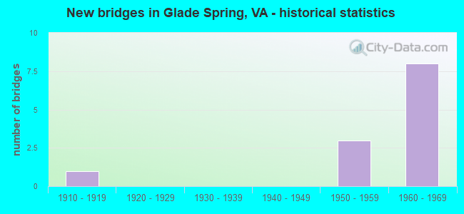
- New bridges - historical statistics
- 11910-1919
- 31950-1959
- 81960-1969

- Reconstructed bridges - Historical Statistics
- 11980-1989
- 01990-1999
- 12000-2009
- 12010-2019


- Bridge Condition - Deck
- 40.0%Good
- 40.0%Satisfactory
- 20.0%Fair

- Bridge Condition - Superstructure
- 40.0%Good
- 20.0%Satisfactory
- 40.0%Fair

- Bridge Condition - Substructure
- 40.0%Good
- 40.0%Satisfactory
- 20.0%Fair

- Bridge Condition - Channel
- 75.0%Fair
- 25.0%Poor

- Bridge Condition - Culverts
- 33.3%Satisfactory
- 66.7%Fair
Find on map >> Show street view
Structure Number: 18834, Location: 0004BEG SR RD0152END SR R (Lat: 36.782544, Lng: -81.734178), Route carried "on" structure: ServiceCounty highway F034, Year Built: 1963, Status: Open, Structure Length: 1.68m (5.51ft), Average Daily Traffic: 71 (year 2013), Average Future Daily Traffic: 81 (year 2040), Design Load: HS 20, Features Intersected: HUTTON CREEK
Minimum Vertical Clearance: 30+ m (98+ ft), Kilometerpoint: 0.080, Lanes on structure: 1, Owner: State Highway Agency, Approaching Roadway Width: 14.0m (45.9ft), Skew: 4 degrees, Material/Design: Concrete, Design/Construction: Culvert, Number Of Spans In Main Unit: 4, Length of Maximum Span: 4.0m (13.1ft)
Condition: Channel: Fair, Culverts: Satisfactory, Operating Rating: 44.5 metric tons, Method Used To Determine Operating Rating: Field evaluation and documented engineering judgment, Inventory Rating: 32.7 metric tons, Method Used To Determine Inventory Rating: Field evaluation and documented engineering judgment, Structural Evaluation: Equal to present minimum criteria, Waterway Adequacy: Better than present minimum criteria, Approach Roadway Alignment: Better than present minimum criteria, Designated Inspection Frequency: Every 24 months, Inspection Date: July 2021
Find on map >> Show street view
Structure Number: 18835, Location: 2.05MTOSMYTHCO&.1OMTO81 (Lat: 36.784214, Lng: -81.734556), Route carried "on" structure: US 11, Year Built: 1918, Status: Open, Structure Length: 0.85m (2.79ft), Average Daily Traffic: 2,183 (year 2020), Truck Traffic: 2%, Average Future Daily Traffic: 2,401 (year 2040), Design Load: H 15, Features Intersected: HUTTON CREEK, Facility Carried by Structure: LEE HIGHWAY
Minimum Vertical Clearance: 30+ m (98+ ft), Kilometerpoint: 49.533, Lanes on structure: 2, Owner: State Highway Agency, Approaching Roadway Width: 12.8m (42.0ft), Material/Design: Concrete, Design/Construction: Tee Beam, Number Of Spans In Main Unit: 1, Length of Maximum Span: 7.9m (25.9ft), Curb-To-Curb Width: 10.1m (33.1ft), Out-to-Out Width: 11.0m (36.1ft)
Condition: Deck: Fair, Superstructure: Fair, Substructure: Fair, Channel: Fair, Operating Rating: 47.2 metric tons, Method Used To Determine Operating Rating: Load Factor (LF), Inventory Rating: 28.1 metric tons, Method Used To Determine Inventory Rating: Load Factor (LF), Structural Evaluation: Somewhat better than minimum adequacy, Deck Geometry: Meets minimum limits, Waterway Adequacy: Equal to present minimum criteria, Approach Roadway Alignment: Better than present minimum criteria, Length Of Structure Improvement: 0.85m (2.79ft), Designated Inspection Frequency: Every 24 months, Inspection Date: May 2021, Bridge Improvement Cost: $85,000, Roadway Improvement Cost: $16,000, Total Project Cost: $131,000 ( Estimate for 2015), Deck Structure Type: Concrete Cast-file-Place, Wearing Surface/Protective System: Wearing Surface: Bituminous
Find on map >> Show street view
Structure Number: 18846, Location: 1.36 TO 835; 0.30 FR. 661 (Lat: 36.782667, Lng: -81.735056), Route carried "on" structure: US 11, Year Built: 1963, Year Reconstructed: 2013, Status: Open, Structure Length: 6.71m (22.01ft), Average Daily Traffic: 2,183 (year 2020), Truck Traffic: 4%, Average Future Daily Traffic: 2,401 (year 2040), Design Load: HS 20+Mod, Features Intersected: I-81
Minimum Vertical Clearance: 30+ m (98+ ft), Kilometerpoint: 49.282, Lanes on structure: 2, Lanes under structure: 4, Owner: State Highway Agency, Approaching Roadway Width: 10.7m (35.1ft), Skew: 2 degrees, Material/Design: Steel, Design/Construction: Stringer/Multi-beam, Number Of Spans In Main Unit: 4, Length of Maximum Span: 19.5m (64.0ft), Curb or Sidewalk Widths: Left: 0.5m (1.6ft), Right: 0.5m (1.6ft), Curb-To-Curb Width: 8.5m (27.9ft), Out-to-Out Width: 10.3m (33.8ft)
Condition: Deck: Good, Superstructure: Good, Substructure: Good, Operating Rating: 56.2 metric tons, Method Used To Determine Operating Rating: Load and Resistance Factor (LRFR), Inventory Rating: 43.5 metric tons, Method Used To Determine Inventory Rating: Load and Resistance Factor (LRFR), Structural Evaluation: Better than present minimum criteria, Deck Geometry: Meets minimum limits, Underclear: Better than present minimum criteria, Approach Roadway Alignment: Better than present minimum criteria, Length Of Structure Improvement: 6.71m (22.01ft), Designated Inspection Frequency: Every 24 months, Inspection Date: November 2021, Deck Structure Type: Concrete Cast-file-Place
Find on map >> Show street view
Structure Number: 18934, Location: 2.99 FR 737; 2.66 TO 11 (Lat: 36.771983, Lng: -81.781217), Route carried "on" structure: Interstate 81, Year Built: 1962, Status: Open, Structure Length: 4.54m (14.90ft), Average Daily Traffic: 15,989 (year 2020), Truck Traffic: 21%, Average Future Daily Traffic: 22,385 (year 2040), Design Load: HS 20+Mod, Features Intersected: ROUTE 91
Minimum Vertical Clearance: 30+ m (98+ ft), Kilometerpoint: 47.996, Lanes on structure: 2, Lanes under structure: 4, Base Highway Network: Yes, Owner: State Highway Agency, Approaching Roadway Width: 14.9m (48.9ft), Skew: 1 degrees, Material/Design: Prestressed concrete, Design/Construction: Stringer/Multi-beam, Number Of Spans In Main Unit: 3, Length of Maximum Span: 19.2m (63.0ft), Curb-To-Curb Width: 12.8m (42.0ft), Out-to-Out Width: 13.4m (44.0ft)
Condition: Deck: Satisfactory, Superstructure: Fair, Substructure: Good, Operating Rating: 77.1 metric tons, Method Used To Determine Operating Rating: Load and Resistance Factor (LRFR), Inventory Rating: 46.3 metric tons, Method Used To Determine Inventory Rating: Load and Resistance Factor (LRFR), Structural Evaluation: Somewhat better than minimum adequacy, Deck Geometry: Equal to present desirable criteria, Underclear: Meets minimum limits, Approach Roadway Alignment: Better than present minimum criteria, Length Of Structure Improvement: 4.54m (14.90ft), Designated Inspection Frequency: Every 24 months, Inspection Date: June 2020, Bridge Improvement Cost: $130,000, Roadway Improvement Cost: $11,000, Total Project Cost: $183,000 ( Estimate for 2014), Deck Structure Type: Concrete Cast-file-Place, Wearing Surface/Protective System: Wearing Surface: Latex Concrete, Membrane: Built-up, Deck Protection: Other
Find on map >> Show street view
Structure Number: 18936, Location: 2.99 FR. 737; 2.66 TO 11. (Lat: 36.771758, Lng: -81.781222), Route carried "on" structure: Interstate 81, Year Built: 1962, Year Reconstructed: 1987, Status: Open, Structure Length: 4.72m (15.49ft), Average Daily Traffic: 16,183 (year 2020), Truck Traffic: 21%, Average Future Daily Traffic: 22,656 (year 2040), Design Load: HS 20+Mod, Features Intersected: ROUTE 91
Minimum Vertical Clearance: 30+ m (98+ ft), Kilometerpoint: 47.369, Lanes on structure: 2, Lanes under structure: 4, Base Highway Network: Yes, Owner: State Highway Agency, Approaching Roadway Width: 14.9m (48.9ft), Skew: 1 degrees, Material/Design: Prestressed concrete, Design/Construction: Stringer/Multi-beam, Number Of Spans In Main Unit: 3, Length of Maximum Span: 19.2m (63.0ft), Curb-To-Curb Width: 12.8m (42.0ft), Out-to-Out Width: 13.4m (44.0ft)
Condition: Deck: Satisfactory, Superstructure: Satisfactory, Substructure: Satisfactory, Operating Rating: 59.9 metric tons, Method Used To Determine Operating Rating: Load and Resistance Factor (LRFR), Inventory Rating: 45.4 metric tons, Method Used To Determine Inventory Rating: Load and Resistance Factor (LRFR), Structural Evaluation: Equal to present minimum criteria, Deck Geometry: Equal to present desirable criteria, Underclear: Meets minimum limits, Approach Roadway Alignment: Better than present minimum criteria, Length Of Structure Improvement: 4.72m (15.49ft), Designated Inspection Frequency: Every 24 months, Inspection Date: June 2020, Bridge Improvement Cost: $150,000, Roadway Improvement Cost: $20,000, Total Project Cost: $221,000 ( Estimate for 2014), Deck Structure Type: Concrete Cast-file-Place, Wearing Surface/Protective System: Wearing Surface: Latex Concrete, Membrane: Built-up, Deck Protection: Other
Find on map >> Show street view
Structure Number: 18955, Location: 0.04FR11; 2.14T SMYTHCO (Lat: 36.783306, Lng: -81.734331), Route carried "on" structure: Interstate 81, Year Built: 1963, Status: Open, Structure Length: 1.49m (4.89ft), Average Daily Traffic: 15,676 (year 2020), Truck Traffic: 21%, Average Future Daily Traffic: 21,946 (year 2040), Design Load: HS 20, Features Intersected: HUTTON CREEK
Minimum Vertical Clearance: 30+ m (98+ ft), Kilometerpoint: 52.352, Lanes on structure: 4, Base Highway Network: Yes, Owner: State Highway Agency, Approaching Roadway Width: 36.3m (119.1ft), Skew: 3 degrees, Material/Design: Concrete, Design/Construction: Culvert, Number Of Spans In Main Unit: 4, Length of Maximum Span: 3.7m (12.1ft)
Condition: Channel: Poor, Culverts: Fair, Operating Rating: 44.5 metric tons, Method Used To Determine Operating Rating: Field evaluation and documented engineering judgment, Inventory Rating: 32.7 metric tons, Method Used To Determine Inventory Rating: Field evaluation and documented engineering judgment, Structural Evaluation: Somewhat better than minimum adequacy, Waterway Adequacy: Better than present minimum criteria, Approach Roadway Alignment: Better than present minimum criteria, Length Of Structure Improvement: 1.49m (4.89ft), Designated Inspection Frequency: Every 24 months, Inspection Date: July 2021, Bridge Improvement Cost: $30,000, Roadway Improvement Cost: $5,000, Total Project Cost: $46,000 ( Estimate for 2015)
Find on map >> Show street view
Structure Number: 18971, Location: 6.51 TO SMYTH&2.08 FR R11 (Lat: 36.792933, Lng: -81.765064), Route carried "on" structure: State highway 91, Year Built: 1959, Year Reconstructed: 2016, Status: Open, Structure Length: 6.82m (22.38ft), Average Daily Traffic: 3,559 (year 2020), Truck Traffic: 6%, Average Future Daily Traffic: 4,983 (year 2040), Design Load: HL 93, Features Intersected: RTE 609; NS RAILWAY, Facility Carried by Structure: MONTE VISTA DR.
Minimum Vertical Clearance: 30+ m (98+ ft), Kilometerpoint: 27.141, Lanes on structure: 2, Lanes under structure: 2, Owner: State Highway Agency, Approaching Roadway Width: 7.1m (23.3ft), Skew: 2 degrees, Material/Design: Steel continuous, Design/Construction: Stringer/Multi-beam, Number Of Spans In Main Unit: 4, Length of Maximum Span: 20.2m (66.3ft), Curb-To-Curb Width: 8.9m (29.2ft), Out-to-Out Width: 9.6m (31.5ft)
Condition: Deck: Good, Superstructure: Good, Substructure: Satisfactory, Operating Rating: 89.8 metric tons, Method Used To Determine Operating Rating: Load and Resistance Factor (LRFR), Inventory Rating: 74.4 metric tons, Method Used To Determine Inventory Rating: Load and Resistance Factor (LRFR), Structural Evaluation: Equal to present minimum criteria, Deck Geometry: Meets minimum limits, Underclear: Somewhat better than minimum adequacy, Approach Roadway Alignment: Better than present minimum criteria, Designated Inspection Frequency: Every 24 months, Inspection Date: April 2020, Deck Structure Type: Concrete Cast-file-Place
Find on map >> Show street view
Structure Number: 18976, Location: 6.62 FR SCL-1.97 TO RT11 (Lat: 36.791681, Lng: -81.765000), Route carried "on" structure: State highway 91, Year Built: 1959, Status: Open, Structure Length: 0.67m (2.20ft), Average Daily Traffic: 3,559 (year 2020), Truck Traffic: 6%, Average Future Daily Traffic: 4,983 (year 2040), Features Intersected: BRANCH, Facility Carried by Structure: MONTE VISTA DRIVE
Minimum Vertical Clearance: 30+ m (98+ ft), Kilometerpoint: 27.025, Lanes on structure: 2, Owner: State Highway Agency, Approaching Roadway Width: 11.6m (38.1ft), Material/Design: Concrete, Design/Construction: Culvert, Number Of Spans In Main Unit: 3, Length of Maximum Span: 2.1m (6.9ft)
Condition: Channel: Fair, Culverts: Fair, Operating Rating: 44.5 metric tons, Method Used To Determine Operating Rating: Field evaluation and documented engineering judgment, Inventory Rating: 32.7 metric tons, Method Used To Determine Inventory Rating: Field evaluation and documented engineering judgment, Structural Evaluation: Somewhat better than minimum adequacy, Waterway Adequacy: Better than present minimum criteria, Approach Roadway Alignment: Better than present minimum criteria, Designated Inspection Frequency: Every 24 months, Inspection Date: Febuary 2022
Find on map >> Show street view
Structure Number: 18846, Location: 1.36 TO 835; 0.30 FR. 661 (Lat: 36.782667, Lng: -81.735056), Route carried "under" structure: Interstate 81, Year Built: 1963, Structure Length: 0. m, Average Daily Traffic: 51,000 (year 2020), Truck Traffic: 22%, Features Intersected: I-81, Facility Carried by Structure: US-11(LEE HIGHWAY)
Minimum Vertical Clearance: 5.28m (17.32ft), Kilometerpoint: 0.000, Lanes on structure: 2, Lanes under structure: 4, Material/Design: Steel, Design/Construction: Stringer/Multi-beam, Length of Maximum Span: 19.5m (64.0ft)
Find on map >> Show street view
Structure Number: 18934, Location: 2.99 FR 737; 2.66 TO 11 (Lat: 36.771983, Lng: -81.781217), Route carried "under" structure: State highway 91, Year Built: 1962, Structure Length: 0. m, Average Daily Traffic: 9,004 (year 2019), Truck Traffic: 2%, Features Intersected: ROUTE 91, Facility Carried by Structure: I-81 SBL
Minimum Vertical Clearance: 4.34m (14.24ft), Kilometerpoint: 0.080, Lanes on structure: 2, Lanes under structure: 4, Material/Design: Prestressed concrete, Design/Construction: Stringer/Multi-beam, Length of Maximum Span: 19.2m (63.0ft)
Find on map >> Show street view
Structure Number: 18936, Location: 2.99 FR. 737; 2.66 TO 11. (Lat: 36.771758, Lng: -81.781222), Route carried "under" structure: State highway 91, Year Built: 1962, Structure Length: 0. m, Average Daily Traffic: 9,004 (year 2019), Truck Traffic: 2%, Features Intersected: ROUTE 91, Facility Carried by Structure: I-81 NBL
Minimum Vertical Clearance: 4.85m (15.91ft), Kilometerpoint: 0.064, Lanes on structure: 2, Lanes under structure: 4, Material/Design: Prestressed concrete, Design/Construction: Stringer/Multi-beam, Length of Maximum Span: 19.2m (63.0ft)
Find on map >> Show street view
Structure Number: 18971, Location: 6.51 TO SMYTH&2.08 FR R11 (Lat: 36.792933, Lng: -81.765064), Route carried "under" structure: County highway 609, Year Built: 1959, Structure Length: 0. m, Average Daily Traffic: 818 (year 2008), Features Intersected: RTE 609; NS RAILWAY, Facility Carried by Structure: MONTE VISTA DR.
Minimum Vertical Clearance: 7.80m (25.59ft), Kilometerpoint: 15.865, Lanes on structure: 2, Lanes under structure: 2, Material/Design: Steel continuous, Design/Construction: Stringer/Multi-beam, Length of Maximum Span: 20.2m (66.3ft)