Bridge Statistics for Glasgow, Montana (MT)
Condition, Traffic, Stress, Structural Evaluation, Project Costs
- National Bridge Inventory (NBI) Statistics
- 15Number of bridges
- 203ft / 61.8mTotal length
- $477,000Total costs
- 17,687Total average daily traffic
- 599Total average daily truck traffic
- 18,537Total future (year 2037) average daily traffic
- National Bridge Inventory (NBI) Registered Bridges for Glasgow
- No street view available for this location
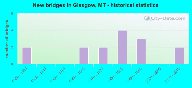
- New bridges - historical statistics
- 21930-1939
- 21960-1969
- 21970-1979
- 41980-1989
- 31990-1999
- 22010-2019


- Bridge Condition - Deck
- 7.7%Very good
- 38.5%Good
- 46.2%Satisfactory
- 7.7%Fair

- Bridge Condition - Superstructure
- 38.5%Good
- 53.8%Satisfactory
- 7.7%Fair

- Bridge Condition - Substructure
- 46.2%Good
- 23.1%Satisfactory
- 23.1%Fair
- 7.7%Poor

- Bridge Condition - Channel
- 26.7%Very good
- 46.7%Good
- 20.0%Satisfactory
- 6.7%Fair
Find on map >> Show street view
Structure Number: L53010002+02001, Location: 3M N GLASGOW (Lat: 48.242106, Lng: -106.634856), Route carried "on" structure: County highway 53231, Year Built: 2012, Status: Open, Structure Length: 2.44m (8.01ft), Average Daily Traffic: 100 (year 2022), Truck Traffic: 3%, Average Future Daily Traffic: 100 (year 2037), Design Load: HL 93, Features Intersected: CHERRY CREEK 093, Facility Carried by Structure: SKYLARK RD
Minimum Vertical Clearance: 30+ m (98+ ft), Kilometerpoint: 3.453, Lanes on structure: 2, Owner: County Highway Agency, Approaching Roadway Width: 7.3m (24.0ft), Material/Design: Prestressed concrete, Design/Construction: Stringer/Multi-beam, Number Of Spans In Main Unit: 1, Length of Maximum Span: 23.6m (77.4ft), Curb-To-Curb Width: 7.3m (24.0ft), Out-to-Out Width: 8.0m (26.2ft)
Condition: Deck: Good, Superstructure: Good, Substructure: Satisfactory, Channel: Very good, Operating Rating: 43.4 metric tons, Method Used To Determine Operating Rating: Load and Resistance Factor (LRFR), Inventory Rating: 35.4 metric tons, Method Used To Determine Inventory Rating: Load and Resistance Factor (LRFR), Structural Evaluation: Equal to present minimum criteria, Deck Geometry: Equal to present minimum criteria, Waterway Adequacy: Equal to present desirable criteria, Approach Roadway Alignment: Better than present minimum criteria, Designated Inspection Frequency: Every 24 months, Inspection Date: November 2020
Find on map >> Show street view
Structure Number: L53508000+01001, Location: 3M NW GLASGOW (Lat: 48.242472, Lng: -106.687111), Route carried "on" structure: County highway 53404, Year Built: 1986, Status: Posted for load, Structure Length: 0.73m (2.40ft), Average Daily Traffic: 100 (year 2022), Truck Traffic: 3%, Average Future Daily Traffic: 100 (year 2037), Features Intersected: RICHARDSON COULEE 090, Facility Carried by Structure: RIVERSIDE DR
Minimum Vertical Clearance: 30+ m (98+ ft), Kilometerpoint: 0.125, Lanes on structure: 2, Owner: County Highway Agency, Approaching Roadway Width: 6.7m (22.0ft), Material/Design: Wood or Timber, Design/Construction: Stringer/Multi-beam, Number Of Spans In Main Unit: 1, Length of Maximum Span: 6.7m (22.0ft), Curb-To-Curb Width: 5.9m (19.4ft), Out-to-Out Width: 6.1m (20.0ft)
Condition: Deck: Satisfactory, Superstructure: Satisfactory, Substructure: Poor, Channel: Very good, Operating Rating: 20.0 metric tons, Method Used To Determine Operating Rating: Allowable Stress (AS), Inventory Rating: 14.5 metric tons, Method Used To Determine Inventory Rating: Allowable Stress (AS), Structural Evaluation: Meets minimum limits, Deck Geometry: Meets minimum limits, Waterway Adequacy: Equal to present desirable criteria, Approach Roadway Alignment: Better than present minimum criteria, Bridge Posting: Required (Relationship of Operating Rating to Maximum Legal Load: > 39.9% below), Designated Inspection Frequency: Every 24 months, Inspection Date: April 2020, Deck Structure Type: Wood or Timber, Wearing Surface/Protective System: Wearing Surface: Wood or Timber
Find on map >> Show street view
Structure Number: L53513028+04001, Location: 4M W GLASGOW (Lat: 48.204750, Lng: -106.713667), Route carried "on" structure: County highway 53405, Year Built: 1938, Status: Posted for load, Structure Length: 1.86m (6.10ft), Average Daily Traffic: 100 (year 2022), Truck Traffic: 3%, Average Future Daily Traffic: 100 (year 2037), Features Intersected: VANDALIA SOUTH CANAL 089, Facility Carried by Structure: BENTONITE RD
Minimum Vertical Clearance: 30+ m (98+ ft), Kilometerpoint: 2.779, Lanes on structure: 2, Owner: County Highway Agency, Approaching Roadway Width: 7.3m (24.0ft), Skew: 5 degrees, Material/Design: Steel continuous, Design/Construction: Stringer/Multi-beam, Number Of Spans In Main Unit: 2, Length of Maximum Span: 9.1m (29.9ft), Curb-To-Curb Width: 5.8m (19.0ft), Out-to-Out Width: 6.1m (20.0ft)
Condition: Deck: Good, Superstructure: Satisfactory, Substructure: Fair, Channel: Good, Operating Rating: 26.3 metric tons, Method Used To Determine Operating Rating: Load Factor (LF), Inventory Rating: 16.3 metric tons, Method Used To Determine Inventory Rating: Load Factor (LF), Structural Evaluation: Somewhat better than minimum adequacy, Deck Geometry: Meets minimum limits, Waterway Adequacy: Equal to present desirable criteria, Approach Roadway Alignment: Somewhat better than minimum adequacy, Designated Inspection Frequency: Every 24 months, Inspection Date: April 2020, Deck Structure Type: Corrugated Steel, Wearing Surface/Protective System: Wearing Surface: Gravel
Find on map >> Show street view
Structure Number: L53578000+02001, Location: SW EDGE GLASGOW (Lat: 48.193722, Lng: -106.649528), Route carried "on" structure: County highway 53421, Year Built: 1938, Year Reconstructed: 2006, Status: Posted for load, Structure Length: 4.88m (16.01ft), Average Daily Traffic: 100 (year 2022), Truck Traffic: 3%, Average Future Daily Traffic: 100 (year 2037), Features Intersected: CHERRY CREEK 080, Facility Carried by Structure: AITKEN RD
Minimum Vertical Clearance: 30+ m (98+ ft), Kilometerpoint: 0.948, Lanes on structure: 2, Owner: County Highway Agency, Approaching Roadway Width: 7.9m (25.9ft), Material/Design: Steel, Design/Construction: Stringer/Multi-beam, Number Of Spans In Main Unit: 1, Number Of Approach Spans: 6, Length of Maximum Span: 8.7m (28.5ft), Curb-To-Curb Width: 6.5m (21.3ft), Out-to-Out Width: 6.7m (22.0ft)
Condition: Deck: Good, Superstructure: Satisfactory, Substructure: Fair, Channel: Good, Operating Rating: 37.2 metric tons, Method Used To Determine Operating Rating: Load Factor (LF), Inventory Rating: 22.7 metric tons, Method Used To Determine Inventory Rating: Load Factor (LF), Structural Evaluation: Somewhat better than minimum adequacy, Deck Geometry: Somewhat better than minimum adequacy, Waterway Adequacy: Somewhat better than minimum adequacy, Approach Roadway Alignment: Somewhat better than minimum adequacy, Bridge Posting: Required (Relationship of Operating Rating to Maximum Legal Load: 0.1 - 9.9% below), Length Of Structure Improvement: 5.90m (19.36ft), Designated Inspection Frequency: Every 24 months, Inspection Date: November 2020, Bridge Improvement Cost: $209,000, Roadway Improvement Cost: $42,000, Total Project Cost: $262,000, Deck Structure Type: Wood or Timber, Wearing Surface/Protective System: Wearing Surface: Wood or Timber
Find on map >> Show street view
Structure Number: L53578000+05001, Location: SW GLASGOW (Lat: 48.193286, Lng: -106.653833), Route carried "on" structure: County highway 53421, Year Built: 1997, Status: Open, Structure Length: 7.03m (23.06ft), Average Daily Traffic: 100 (year 2022), Truck Traffic: 3%, Average Future Daily Traffic: 100 (year 2037), Design Load: HL 93, Features Intersected: MILK RIVER 081, Facility Carried by Structure: AITKEN RD
Minimum Vertical Clearance: 30+ m (98+ ft), Kilometerpoint: 1.275, Lanes on structure: 2, Owner: County Highway Agency, Approaching Roadway Width: 7.0m (23.0ft), Material/Design: Steel continuous, Design/Construction: Stringer/Multi-beam, Number Of Spans In Main Unit: 3, Length of Maximum Span: 27.0m (88.6ft), Curb-To-Curb Width: 7.2m (23.6ft), Out-to-Out Width: 7.9m (25.9ft)
Condition: Deck: Satisfactory, Superstructure: Good, Substructure: Good, Channel: Satisfactory, Operating Rating: 45.4 metric tons, Method Used To Determine Operating Rating: Load and Resistance Factor (LRFR), Inventory Rating: 35.0 metric tons, Method Used To Determine Inventory Rating: Load and Resistance Factor (LRFR), Structural Evaluation: Better than present minimum criteria, Deck Geometry: Somewhat better than minimum adequacy, Waterway Adequacy: Somewhat better than minimum adequacy, Approach Roadway Alignment: Equal to present minimum criteria, Designated Inspection Frequency: Every 24 months, Inspection Date: May 2021, Deck Structure Type: Concrete Cast-file-Place, Wearing Surface/Protective System: Wearing Surface: Monolithic Concrete
Find on map >> Show street view
Structure Number: L53582001+06001, Location: 3M W GLASGOW (Lat: 48.205033, Lng: -106.685833), Route carried "on" structure: County highway 53422, Year Built: 2013, Status: Open, Structure Length: 3.74m (12.27ft), Average Daily Traffic: 100 (year 2022), Truck Traffic: 3%, Average Future Daily Traffic: 100 (year 2037), Features Intersected: BRAZIL CREEK 079, Facility Carried by Structure: CANAL RD
Minimum Vertical Clearance: 30+ m (98+ ft), Kilometerpoint: 2.552, Lanes on structure: 2, Owner: County Highway Agency, Approaching Roadway Width: 6.1m (20.0ft), Material/Design: Prestressed concrete, Design/Construction: Tee Beam, Number Of Spans In Main Unit: 1, Length of Maximum Span: 36.6m (120.1ft), Curb-To-Curb Width: 7.3m (24.0ft), Out-to-Out Width: 8.1m (26.6ft)
Condition: Deck: Good, Superstructure: Good, Substructure: Good, Channel: Fair, Operating Rating: 49.9 metric tons, Method Used To Determine Operating Rating: Load and Resistance Factor (LRFR), Inventory Rating: 33.6 metric tons, Method Used To Determine Inventory Rating: Load and Resistance Factor (LRFR), Structural Evaluation: Better than present minimum criteria, Deck Geometry: Equal to present minimum criteria, Waterway Adequacy: Equal to present desirable criteria, Approach Roadway Alignment: Equal to present minimum criteria, Length Of Structure Improvement: 4.60m (15.09ft), Designated Inspection Frequency: Every 24 months, Inspection Date: April 2020, Bridge Improvement Cost: $143,000, Roadway Improvement Cost: $72,000, Total Project Cost: $215,000, Deck Structure Type: Concrete Precast Panels, Wearing Surface/Protective System: Wearing Surface: Monolithic Concrete
Find on map >> Show street view
Structure Number: L53583002+07001, Location: 2M SW GLASGOW (Lat: 48.182944, Lng: -106.682556), Route carried "on" structure: County highway 53482, Year Built: 1988, Status: Open, Structure Length: 1.16m (3.81ft), Average Daily Traffic: 100 (year 2022), Truck Traffic: 3%, Average Future Daily Traffic: 100 (year 2037), Features Intersected: VANDALIA SOUTH CANAL 113, Facility Carried by Structure: BRAZIL CREEK RD
Minimum Vertical Clearance: 30+ m (98+ ft), Kilometerpoint: 1.460, Lanes on structure: 2, Owner: County Highway Agency, Approaching Roadway Width: 6.1m (20.0ft), Skew: 2 degrees, Material/Design: Steel, Design/Construction: Stringer/Multi-beam, Number Of Spans In Main Unit: 1, Length of Maximum Span: 11.3m (37.1ft), Curb-To-Curb Width: 5.9m (19.4ft), Out-to-Out Width: 6.0m (19.7ft)
Condition: Deck: Very good, Superstructure: Fair, Substructure: Satisfactory, Channel: Very good, Operating Rating: 45.4 metric tons, Method Used To Determine Operating Rating: Load Factor (LF), Inventory Rating: 27.2 metric tons, Method Used To Determine Inventory Rating: Load Factor (LF), Structural Evaluation: Somewhat better than minimum adequacy, Deck Geometry: Meets minimum limits, Waterway Adequacy: Equal to present desirable criteria, Approach Roadway Alignment: Equal to present minimum criteria, Designated Inspection Frequency: Every 24 months, Inspection Date: April 2020, Deck Structure Type: Corrugated Steel, Wearing Surface/Protective System: Wearing Surface: Gravel
Find on map >> Show street view
Structure Number: P00001537+06421, Location: 4M NW GLASGOW (Lat: 48.242917, Lng: -106.686222), Route carried "on" structure: US 2, Year Built: 1979, Status: Open, Structure Length: 1.00m (3.28ft), Average Daily Traffic: 1,236 (year 2020), Truck Traffic: 7%, Average Future Daily Traffic: 1,298 (year 2040), Design Load: HS 20, Features Intersected: RICHARDSON COULEE
Minimum Vertical Clearance: 30+ m (98+ ft), Kilometerpoint: 862.426, Lanes on structure: 2, Base Highway Network: Yes, Owner: State Highway Agency, Approaching Roadway Width: 14.0m (45.9ft), Material/Design: Steel, Design/Construction: Culvert, Number Of Spans In Main Unit: 2, Length of Maximum Span: 4.3m (14.1ft)
Condition: Channel: Good, Culverts: Satisfactory, Operating Rating: 68.0 metric tons, Method Used To Determine Operating Rating: Load and Resistance Factor (LRFR), Inventory Rating: 64.4 metric tons, Method Used To Determine Inventory Rating: Load and Resistance Factor (LRFR), Structural Evaluation: Equal to present minimum criteria, Waterway Adequacy: Equal to present desirable criteria, Approach Roadway Alignment: Equal to present desirable criteria, Designated Inspection Frequency: Every 24 months, Inspection Date: November 2020
Find on map >> Show street view
Structure Number: P00001539+09441, Location: 1M N GLASGOW (Lat: 48.218678, Lng: -106.652281), Route carried "on" structure: US 2, Year Built: 1980, Status: Open, Structure Length: 3.51m (11.52ft), Average Daily Traffic: 5,886 (year 2020), Truck Traffic: 3%, Average Future Daily Traffic: 6,180 (year 2040), Design Load: HS 20, Features Intersected: CHERRY CREEK OVERFLOW
Minimum Vertical Clearance: 30+ m (98+ ft), Kilometerpoint: 866.131, Lanes on structure: 2, Base Highway Network: Yes, Owner: State Highway Agency, Approaching Roadway Width: 13.4m (44.0ft), Material/Design: Concrete continuous, Design/Construction: Slab, Number Of Spans In Main Unit: 4, Length of Maximum Span: 9.8m (32.2ft), Curb-To-Curb Width: 14.4m (47.2ft), Out-to-Out Width: 15.3m (50.2ft)
Condition: Deck: Satisfactory, Superstructure: Satisfactory, Substructure: Good, Channel: Good, Operating Rating: 51.7 metric tons, Method Used To Determine Operating Rating: Load Factor (LF), Inventory Rating: 30.8 metric tons, Method Used To Determine Inventory Rating: Load Factor (LF), Structural Evaluation: Equal to present minimum criteria, Deck Geometry: Superior to present desirable criteria, Waterway Adequacy: Equal to present desirable criteria, Approach Roadway Alignment: Equal to present desirable criteria, Designated Inspection Frequency: Every 24 months, Inspection Date: November 2020, Deck Structure Type: Concrete Cast-file-Place, Wearing Surface/Protective System: Wearing Surface: Monolithic Concrete
Find on map >> Show street view
Structure Number: P00001540+03401, Location: 1M N GLASGOW (Lat: 48.214508, Lng: -106.646836), Route carried "on" structure: US 2, Year Built: 1979, Status: Open, Structure Length: 3.51m (11.52ft), Average Daily Traffic: 5,886 (year 2020), Truck Traffic: 3%, Average Future Daily Traffic: 6,180 (year 2040), Design Load: HS 20, Features Intersected: CHERRY CREEK
Minimum Vertical Clearance: 30+ m (98+ ft), Kilometerpoint: 866.769, Lanes on structure: 2, Base Highway Network: Yes, Owner: State Highway Agency, Approaching Roadway Width: 13.4m (44.0ft), Material/Design: Concrete continuous, Design/Construction: Slab, Number Of Spans In Main Unit: 4, Length of Maximum Span: 9.8m (32.2ft), Curb-To-Curb Width: 14.4m (47.2ft), Out-to-Out Width: 15.3m (50.2ft)
Condition: Deck: Satisfactory, Superstructure: Satisfactory, Substructure: Fair, Channel: Satisfactory, Operating Rating: 51.7 metric tons, Method Used To Determine Operating Rating: Load Factor (LF), Inventory Rating: 30.8 metric tons, Method Used To Determine Inventory Rating: Load Factor (LF), Structural Evaluation: Somewhat better than minimum adequacy, Deck Geometry: Superior to present desirable criteria, Waterway Adequacy: Equal to present desirable criteria, Approach Roadway Alignment: Better than present minimum criteria, Designated Inspection Frequency: Every 24 months, Inspection Date: November 2020, Deck Structure Type: Concrete Cast-file-Place, Wearing Surface/Protective System: Wearing Surface: Monolithic Concrete
Find on map >> Show street view
Structure Number: P00001546+01061, Location: 4M SE GLASGOW (Lat: 48.165306, Lng: -106.556583), Route carried "on" structure: US 2, Year Built: 1994, Status: Open, Structure Length: 0.74m (2.43ft), Average Daily Traffic: 1,760 (year 2020), Truck Traffic: 7%, Average Future Daily Traffic: 1,848 (year 2040), Design Load: HS 20, Features Intersected: GOUDGE COULEE
Minimum Vertical Clearance: 30+ m (98+ ft), Kilometerpoint: 876.177, Lanes on structure: 2, Base Highway Network: Yes, Owner: State Highway Agency, Approaching Roadway Width: 8.4m (27.6ft), Material/Design: Steel, Design/Construction: Culvert, Number Of Spans In Main Unit: 2, Length of Maximum Span: 3.1m (10.2ft)
Condition: Channel: Good, Culverts: Satisfactory, Structural Evaluation: Equal to present minimum criteria, Waterway Adequacy: Equal to present desirable criteria, Approach Roadway Alignment: Equal to present desirable criteria, Designated Inspection Frequency: Every 24 months, Inspection Date: August 2020
Find on map >> Show street view
Structure Number: P00042072+05701, Location: 3M SE GLASGOW (Lat: 48.159664, Lng: -106.592736), Route carried "on" structure: State highway 24, Year Built: 1992, Status: Open, Structure Length: 12.86m (42.19ft), Average Daily Traffic: 866 (year 2020), Truck Traffic: 2%, Average Future Daily Traffic: 909 (year 2040), Design Load: HS 20, Features Intersected: MILK RIVER
Minimum Vertical Clearance: 30+ m (98+ ft), Kilometerpoint: 116.979, Lanes on structure: 2, Base Highway Network: Yes, Owner: State Highway Agency, Approaching Roadway Width: 11.0m (36.1ft), Material/Design: Prestressed concrete, Design/Construction: Stringer/Multi-beam, Number Of Spans In Main Unit: 5, Length of Maximum Span: 27.7m (90.9ft), Curb-To-Curb Width: 10.9m (35.8ft), Out-to-Out Width: 11.6m (38.1ft)
Condition: Deck: Satisfactory, Superstructure: Satisfactory, Substructure: Good, Channel: Good, Operating Rating: 61.7 metric tons, Method Used To Determine Operating Rating: Load and Resistance Factor (LRFR), Inventory Rating: 48.1 metric tons, Method Used To Determine Inventory Rating: Load and Resistance Factor (LRFR), Structural Evaluation: Equal to present minimum criteria, Deck Geometry: Equal to present minimum criteria, Waterway Adequacy: Equal to present desirable criteria, Approach Roadway Alignment: Equal to present desirable criteria, Designated Inspection Frequency: Every 48 months, Inspection Date: August 2018, Deck Structure Type: Concrete Cast-file-Place, Wearing Surface/Protective System: Wearing Surface: Monolithic Concrete, Deck Protection: Epoxy Coated Reinforcing
Find on map >> Show street view
Structure Number: S00246000+07001, Location: W EDGE OF GLASGOW (Lat: 48.198889, Lng: -106.650250), Route carried "on" structure: State highway 246, Year Built: 1989, Status: Open, Structure Length: 3.66m (12.01ft), Average Daily Traffic: 451 (year 2020), Average Future Daily Traffic: 474 (year 2040), Design Load: HS 15, Features Intersected: CHERRY CREEK, Facility Carried by Structure: 2ND AVE S-TAMPICO
Minimum Vertical Clearance: 30+ m (98+ ft), Kilometerpoint: 1.116, Lanes on structure: 2, Owner: State Highway Agency, Approaching Roadway Width: 8.2m (26.9ft), Material/Design: Concrete continuous, Design/Construction: Tee Beam, Number Of Spans In Main Unit: 4, Length of Maximum Span: 13.7m (44.9ft), Curb-To-Curb Width: 7.3m (24.0ft), Out-to-Out Width: 8.1m (26.6ft)
Condition: Deck: Satisfactory, Superstructure: Good, Substructure: Good, Channel: Good, Operating Rating: 44.5 metric tons, Method Used To Determine Operating Rating: Load and Resistance Factor (LRFR), Inventory Rating: 34.5 metric tons, Method Used To Determine Inventory Rating: Load and Resistance Factor (LRFR), Structural Evaluation: Better than present minimum criteria, Deck Geometry: Meets minimum limits, Waterway Adequacy: Equal to present desirable criteria, Approach Roadway Alignment: Equal to present minimum criteria, Designated Inspection Frequency: Every 24 months, Inspection Date: January 2022, Wearing Surface/Protective System: Wearing Surface: Monolithic Concrete
Find on map >> Show street view
Structure Number: S00246001+01001, Location: 1M W GLASGOW (Lat: 48.202667, Lng: -106.658639), Route carried "on" structure: State highway 246, Year Built: 1960, Status: Open, Structure Length: 2.29m (7.51ft), Average Daily Traffic: 451 (year 2020), Average Future Daily Traffic: 474 (year 2040), Design Load: HS 15, Features Intersected: CHERRY CREEK OVERFLOW, Facility Carried by Structure: TAMPICO RD
Minimum Vertical Clearance: 30+ m (98+ ft), Kilometerpoint: 1.874, Lanes on structure: 2, Owner: State Highway Agency, Approaching Roadway Width: 8.2m (26.9ft), Material/Design: Wood or Timber, Design/Construction: Stringer/Multi-beam, Number Of Spans In Main Unit: 3, Length of Maximum Span: 7.6m (24.9ft), Curb-To-Curb Width: 7.4m (24.3ft), Out-to-Out Width: 7.9m (25.9ft)
Condition: Deck: Good, Superstructure: Good, Substructure: Satisfactory, Channel: Very good, Operating Rating: 33.5 metric tons, Method Used To Determine Operating Rating: Allowable Stress (AS), Inventory Rating: 24.4 metric tons, Method Used To Determine Inventory Rating: Allowable Stress (AS), Structural Evaluation: Equal to present minimum criteria, Deck Geometry: Meets minimum limits, Waterway Adequacy: Equal to present desirable criteria, Approach Roadway Alignment: Equal to present desirable criteria, Designated Inspection Frequency: Every 24 months, Inspection Date: September 2021, Deck Structure Type: Wood or Timber, Wearing Surface/Protective System: Wearing Surface: Bituminous
Find on map >> Show street view
Structure Number: S00246002+01001, Location: 2M W GLASGOW (Lat: 48.208769, Lng: -106.676869), Route carried "on" structure: State highway 246, Year Built: 1960, Status: Open, Structure Length: 12.34m (40.49ft), Average Daily Traffic: 451 (year 2020), Average Future Daily Traffic: 474 (year 2040), Design Load: HS 15, Features Intersected: MILK RIVER, Facility Carried by Structure: TAMPICO RD
Minimum Vertical Clearance: 30+ m (98+ ft), Kilometerpoint: 3.393, Lanes on structure: 2, Owner: State Highway Agency, Approaching Roadway Width: 7.9m (25.9ft), Material/Design: Steel continuous, Design/Construction: Girder and Floorbeam System, Number Of Spans In Main Unit: 3, Length of Maximum Span: 46.9m (153.9ft), Curb-To-Curb Width: 7.3m (24.0ft), Out-to-Out Width: 8.1m (26.6ft)
Condition: Deck: Fair, Superstructure: Satisfactory, Substructure: Good, Channel: Satisfactory, Operating Rating: 32.7 metric tons, Method Used To Determine Operating Rating: Allowable Stress (AS), Inventory Rating: 24.4 metric tons, Method Used To Determine Inventory Rating: Allowable Stress (AS), Structural Evaluation: Equal to present minimum criteria, Deck Geometry: Meets minimum limits, Waterway Adequacy: Equal to present desirable criteria, Approach Roadway Alignment: Better than present minimum criteria, Designated Inspection Frequency: Every 24 months, Critical Feature Inspection Frequency: Every 24 months, Inspection Date: May 2021, Critical Feature Inspection Date: May 2021, Deck Structure Type: Concrete Cast-file-Place, Wearing Surface/Protective System: Wearing Surface: Monolithic Concrete