Bridge Statistics for Glen St. Mary, Florida (FL)
Condition, Traffic, Stress, Structural Evaluation, Project Costs
- National Bridge Inventory (NBI) Statistics
- 10Number of bridges
- 157ft / 47.7mTotal length
- 80,751Total average daily traffic
- 27,789Total average daily truck traffic
- National Bridge Inventory (NBI) Registered Bridges for Glen St. Mary
- No street view available for this location
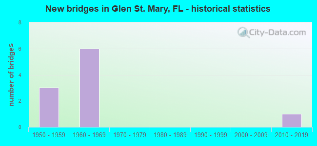
- New bridges - historical statistics
- 31950-1959
- 61960-1969
- 12010-2019


- Bridge Condition - Deck
- 66.7%Good
- 33.3%Satisfactory

- Bridge Condition - Superstructure
- 50.0%Good
- 50.0%Satisfactory

- Bridge Condition - Substructure
- 66.7%Good
- 33.3%Satisfactory

- Bridge Condition - Channel
- 75.0%Good
- 25.0%Fair
Find on map >> Show street view
Structure Number: 270025, Location: 1 MI SOUTH OF I-10 (Lat: 30.248611, Lng: -82.164556), Route carried "on" structure: County highway 125, Year Built: 1950, Status: Open, Structure Length: 1.12m (3.67ft), Average Daily Traffic: 550 (year 2021), Truck Traffic: 23%, Average Future Daily Traffic: 955 (year 2042), Design Load: HS 20, Features Intersected: S PRONG ST MARYS RIVER
Minimum Vertical Clearance: 30+ m (98+ ft), Kilometerpoint: 6.087, Lanes on structure: 2, Owner: County Highway Agency, Approaching Roadway Width: 6.7m (22.0ft), Skew: 3 degrees, Material/Design: Concrete, Design/Construction: Culvert, Number Of Spans In Main Unit: 3, Length of Maximum Span: 3.8m (12.5ft)
Condition: Channel: Fair, Culverts: Satisfactory, Operating Rating: 42.8 metric tons, Method Used To Determine Operating Rating: Load Factor (LF), Inventory Rating: 25.7 metric tons, Method Used To Determine Inventory Rating: Load Factor (LF), Structural Evaluation: Equal to present minimum criteria, Waterway Adequacy: Equal to present desirable criteria, Approach Roadway Alignment: Equal to present desirable criteria, Designated Inspection Frequency: Every 24 months, Inspection Date: August 2021
Find on map >> Show street view
Structure Number: 270044, Location: I-10 WB OVER CR-125 (Lat: 30.261753, Lng: -82.162325), Route carried "on" structure: Interstate 10, Year Built: 1961, Status: Open, Structure Length: 4.39m (14.40ft), Average Daily Traffic: 12,250 (year 2020), Truck Traffic: 35%, Average Future Daily Traffic: 21,254 (year 2042), Design Load: HS 20+Mod, Features Intersected: CR-125
Minimum Vertical Clearance: 30+ m (98+ ft), Kilometerpoint: 29.530, Lanes on structure: 2, Lanes under structure: 2, Base Highway Network: Yes, Owner: State Highway Agency, Approaching Roadway Width: 11.9m (39.0ft), Material/Design: Prestressed concrete, Design/Construction: Stringer/Multi-beam, Number Of Spans In Main Unit: 4, Length of Maximum Span: 11.0m (36.1ft), Curb-To-Curb Width: 12.1m (39.7ft), Out-to-Out Width: 13.0m (42.7ft)
Condition: Deck: Good, Superstructure: Good, Substructure: Good, Operating Rating: 67.0 metric tons, Method Used To Determine Operating Rating: Load Factor (LF), Inventory Rating: 44.7 metric tons, Method Used To Determine Inventory Rating: Load Factor (LF), Structural Evaluation: Better than present minimum criteria, Deck Geometry: Equal to present minimum criteria, Underclear: Equal to present minimum criteria, Approach Roadway Alignment: Equal to present desirable criteria, Designated Inspection Frequency: Every 24 months, Inspection Date: November 2020, Deck Structure Type: Concrete Cast-file-Place
Find on map >> Show street view
Structure Number: 270045, Location: 0.3 MI. E. OF CR-125 (Lat: 30.261219, Lng: -82.154839), Route carried "on" structure: Interstate 10, Year Built: 1960, Year Reconstructed: 1990, Status: Open, Structure Length: 9.27m (30.41ft), Average Daily Traffic: 14,500 (year 2020), Truck Traffic: 35%, Average Future Daily Traffic: 25,158 (year 2042), Design Load: HS 20+Mod, Features Intersected: LITTLE ST. MARY'S RIVER
Minimum Vertical Clearance: 30+ m (98+ ft), Kilometerpoint: 30.211, Lanes on structure: 2, Base Highway Network: Yes, Owner: State Highway Agency, Approaching Roadway Width: 11.6m (38.1ft), Skew: 3 degrees, Material/Design: Prestressed concrete, Design/Construction: Stringer/Multi-beam, Number Of Spans In Main Unit: 8, Length of Maximum Span: 11.6m (38.1ft), Curb-To-Curb Width: 12.2m (40.0ft), Out-to-Out Width: 13.0m (42.7ft)
Condition: Deck: Satisfactory, Superstructure: Satisfactory, Substructure: Satisfactory, Channel: Good, Operating Rating: 54.4 metric tons, Method Used To Determine Operating Rating: Load Testing, Inventory Rating: 32.7 metric tons, Method Used To Determine Inventory Rating: Load Testing, Structural Evaluation: Equal to present minimum criteria, Deck Geometry: Better than present minimum criteria, Waterway Adequacy: Equal to present desirable criteria, Approach Roadway Alignment: Equal to present desirable criteria, Designated Inspection Frequency: Every 24 months, Underwater Inspection Frequency: Every 24 months, Inspection Date: Febuary 2021, Underwater Inspection Date: Febuary 2021, Deck Structure Type: Concrete Cast-file-Place
Find on map >> Show street view
Structure Number: 270055, Location: I-10 EB OVER CR-125 (Lat: 30.261489, Lng: -82.162303), Route carried "on" structure: Interstate 10, Year Built: 1961, Status: Open, Structure Length: 4.39m (14.40ft), Average Daily Traffic: 12,250 (year 2020), Truck Traffic: 35%, Average Future Daily Traffic: 21,254 (year 2042), Design Load: HS 20+Mod, Features Intersected: CR-125
Minimum Vertical Clearance: 30+ m (98+ ft), Kilometerpoint: 29.530, Lanes on structure: 2, Lanes under structure: 2, Base Highway Network: Yes, Owner: State Highway Agency, Approaching Roadway Width: 11.5m (37.7ft), Material/Design: Prestressed concrete, Design/Construction: Stringer/Multi-beam, Number Of Spans In Main Unit: 4, Length of Maximum Span: 11.0m (36.1ft), Curb-To-Curb Width: 12.2m (40.0ft), Out-to-Out Width: 13.0m (42.7ft)
Condition: Deck: Good, Superstructure: Satisfactory, Substructure: Good, Operating Rating: 67.0 metric tons, Method Used To Determine Operating Rating: Load Factor (LF), Inventory Rating: 44.7 metric tons, Method Used To Determine Inventory Rating: Load Factor (LF), Structural Evaluation: Equal to present minimum criteria, Deck Geometry: Better than present minimum criteria, Underclear: Equal to present minimum criteria, Approach Roadway Alignment: Equal to present desirable criteria, Designated Inspection Frequency: Every 24 months, Inspection Date: November 2020, Deck Structure Type: Concrete Cast-file-Place
Find on map >> Show street view
Structure Number: 270056, Location: 0.3 MI. E. OF CR-125 (Lat: 30.260978, Lng: -82.154969), Route carried "on" structure: Interstate 10, Year Built: 1960, Year Reconstructed: 1990, Status: Open, Structure Length: 9.27m (30.41ft), Average Daily Traffic: 14,500 (year 2020), Truck Traffic: 35%, Average Future Daily Traffic: 25,158 (year 2042), Design Load: HS 20+Mod, Features Intersected: LITTLE ST. MARY'S RIVER
Minimum Vertical Clearance: 30+ m (98+ ft), Kilometerpoint: 30.211, Lanes on structure: 2, Base Highway Network: Yes, Owner: State Highway Agency, Approaching Roadway Width: 11.6m (38.1ft), Skew: 3 degrees, Material/Design: Prestressed concrete, Design/Construction: Stringer/Multi-beam, Number Of Spans In Main Unit: 8, Length of Maximum Span: 11.6m (38.1ft), Curb-To-Curb Width: 12.2m (40.0ft), Out-to-Out Width: 13.0m (42.7ft)
Condition: Deck: Satisfactory, Superstructure: Satisfactory, Substructure: Satisfactory, Channel: Good, Operating Rating: 54.4 metric tons, Method Used To Determine Operating Rating: Load Testing, Inventory Rating: 32.7 metric tons, Method Used To Determine Inventory Rating: Load Testing, Structural Evaluation: Equal to present minimum criteria, Deck Geometry: Better than present minimum criteria, Waterway Adequacy: Equal to present desirable criteria, Approach Roadway Alignment: Equal to present desirable criteria, Designated Inspection Frequency: Every 24 months, Underwater Inspection Frequency: Every 24 months, Inspection Date: Febuary 2021, Underwater Inspection Date: Febuary 2021, Deck Structure Type: Concrete Cast-file-Place
Find on map >> Show street view
Structure Number: 270067, Location: CR-123 OVER I-10 (Lat: 30.256111, Lng: -82.191667), Route carried "on" structure: County highway 123, Year Built: 1959, Status: Open, Structure Length: 6.46m (21.19ft), Average Daily Traffic: 601 (year 2021), Truck Traffic: 2%, Average Future Daily Traffic: 1,043 (year 2041), Design Load: H 15, Features Intersected: I-10 SR-8
Minimum Vertical Clearance: 30+ m (98+ ft), Kilometerpoint: 0.190, Lanes on structure: 2, Lanes under structure: 4, Owner: State Highway Agency, Approaching Roadway Width: 7.3m (24.0ft), Skew: 1 degrees, Material/Design: Prestressed concrete, Design/Construction: Stringer/Multi-beam, Number Of Spans In Main Unit: 4, Length of Maximum Span: 21.3m (69.9ft), Curb or Sidewalk Widths: Left: 0.4m (1.3ft), Right: 0.4m (1.3ft), Curb-To-Curb Width: 7.3m (24.0ft), Out-to-Out Width: 8.8m (28.9ft)
Condition: Deck: Good, Superstructure: Good, Substructure: Good, Operating Rating: 40.7 metric tons, Method Used To Determine Operating Rating: Load Factor (LF), Inventory Rating: 33.9 metric tons, Method Used To Determine Inventory Rating: Load Factor (LF), Structural Evaluation: Better than present minimum criteria, Deck Geometry: Meets minimum limits, Underclear: High priority of corrective action, Approach Roadway Alignment: Equal to present desirable criteria, Designated Inspection Frequency: Every 24 months, Inspection Date: January 2021, Deck Structure Type: Concrete Cast-file-Place
Find on map >> Show street view
Structure Number: 274156, Location: 0.5 MILE S OF I-10 (Lat: 30.253194, Lng: -82.162500), Route carried "on" structure: County highway 125, Year Built: 2012, Status: Open, Structure Length: 12.80m (41.99ft), Average Daily Traffic: 500 (year 2020), Truck Traffic: 22%, Average Future Daily Traffic: 868 (year 2042), Design Load: HL 93, Features Intersected: ST. MARY'S RIVER S PRONG
Minimum Vertical Clearance: 30+ m (98+ ft), Kilometerpoint: 6.590, Lanes on structure: 2, Owner: County Highway Agency, Approaching Roadway Width: 8.5m (27.9ft), Skew: 1 degrees, Material/Design: Prestressed concrete, Design/Construction: Stringer/Multi-beam, Number Of Spans In Main Unit: 4, Length of Maximum Span: 32.0m (105.0ft), Curb-To-Curb Width: 13.4m (44.0ft), Out-to-Out Width: 14.4m (47.2ft)
Condition: Deck: Good, Superstructure: Good, Substructure: Good, Channel: Good, Operating Rating: 42.0 metric tons, Method Used To Determine Operating Rating: Load and Resistance Factor (LRFR), Inventory Rating: 38.2 metric tons, Method Used To Determine Inventory Rating: Load and Resistance Factor (LRFR), Structural Evaluation: Better than present minimum criteria, Deck Geometry: Superior to present desirable criteria, Waterway Adequacy: Equal to present desirable criteria, Approach Roadway Alignment: Equal to present desirable criteria, Designated Inspection Frequency: Every 24 months, Inspection Date: September 2020, Deck Structure Type: Concrete Cast-file-Place
Find on map >> Show street view
Structure Number: 270044, Location: I-10 WB OVER CR-125 (Lat: 30.261753, Lng: -82.162325), Route carried "under" structure: County highway 125, Year Built: 1961, Structure Length: 0. m, Average Daily Traffic: 550 (year 2020), Truck Traffic: 22%, Features Intersected: CR-125, Facility Carried by Structure: I-10 WB (SR-8)
Minimum Vertical Clearance: 4.51m (14.80ft), Kilometerpoint: 7.594, Lanes on structure: 2, Lanes under structure: 2, Material/Design: Prestressed concrete, Design/Construction: Stringer/Multi-beam, Length of Maximum Span: 11.0m (36.1ft)
Find on map >> Show street view
Structure Number: 270055, Location: I-10 EB OVER CR-125 (Lat: 30.261489, Lng: -82.162303), Route carried "under" structure: County highway 125, Year Built: 1961, Structure Length: 0. m, Average Daily Traffic: 550 (year 2020), Truck Traffic: 22%, Features Intersected: CR-125, Facility Carried by Structure: I-10 EB (SR-8)
Minimum Vertical Clearance: 4.48m (14.70ft), Kilometerpoint: 7.557, Lanes on structure: 2, Lanes under structure: 2, Material/Design: Prestressed concrete, Design/Construction: Stringer/Multi-beam, Length of Maximum Span: 11.0m (36.1ft)
Find on map >> Show street view
Structure Number: 270067, Location: CR-123 OVER I-10 (Lat: 30.256111, Lng: -82.191667), Route carried "under" structure: Interstate 10, Year Built: 1959, Structure Length: 0. m, Average Daily Traffic: 24,500 (year 2020), Truck Traffic: 35%, Features Intersected: I-10 SR-8, Facility Carried by Structure: CR-123
Minimum Vertical Clearance: 5.12m (16.80ft), Kilometerpoint: 26.639, Lanes on structure: 2, Lanes under structure: 4, Material/Design: Prestressed concrete, Design/Construction: Stringer/Multi-beam, Length of Maximum Span: 21.3m (69.9ft)