Bridge Statistics for Glenaire, Missouri (MO)
Condition, Traffic, Stress, Structural Evaluation, Project Costs
- National Bridge Inventory (NBI) Statistics
- 13Number of bridges
- 125ft / 38.0mTotal length
- $153,000Total costs
- 256,007Total average daily traffic
- 39,820Total average daily truck traffic
- National Bridge Inventory (NBI) Registered Bridges for Glenaire
- No street view available for this location
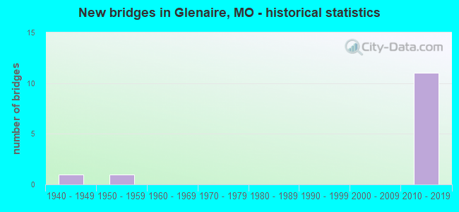
- New bridges - historical statistics
- 11940-1949
- 11950-1959
- 112010-2019


- Bridge Condition - Deck
- 20.0%Very good
- 60.0%Good
- 20.0%Fair

- Bridge Condition - Superstructure
- 20.0%Excellent
- 40.0%Very good
- 20.0%Good
- 20.0%Poor

- Bridge Condition - Substructure
- 40.0%Excellent
- 40.0%Very good
- 20.0%Fair

- Bridge Condition - Channel
- 33.3%Very good
- 66.7%Satisfactory
Find on map >> Show street view
Structure Number: 17848, Location: S 13 T 51 N R 32 W (Lat: 39.218714, Lng: -94.454678), Route carried "on" structure: City street , Year Built: 1940, Status: Closed, Structure Length: 0.73m (2.40ft), Average Daily Traffic: 250 (year 2020), Truck Traffic: 10%, Average Future Daily Traffic: 400 (year 2040), Features Intersected: BR LIT SHOAL CR, Facility Carried by Structure: JOHNSON RD
Minimum Vertical Clearance: 30+ m (98+ ft), Kilometerpoint: 0.161, Lanes on structure: 1, Owner: City or Municipal Highway Agency, Approaching Roadway Width: 5.8m (19.0ft), Material/Design: Steel, Design/Construction: Stringer/Multi-beam, Number Of Spans In Main Unit: 1, Length of Maximum Span: 7.0m (23.0ft), Curb-To-Curb Width: 5.5m (18.0ft), Out-to-Out Width: 5.5m (18.0ft)
Condition: Deck: Fair, Superstructure: Poor, Substructure: Fair, Channel: Satisfactory, Deck Geometry: High priority of corrective action, Waterway Adequacy: Better than present minimum criteria, Approach Roadway Alignment: Equal to present desirable criteria, Bridge Posting: Required (Relationship of Operating Rating to Maximum Legal Load: > 39.9% below), Length Of Structure Improvement: 0.14m (0.46ft), Designated Inspection Frequency: Every 24 months, Inspection Date: December 2019, Bridge Improvement Cost: $102,000, Roadway Improvement Cost: $10,000, Total Project Cost: $153,000 ( Estimate for 2022), Deck Structure Type: Concrete Cast-file-Place, Wearing Surface/Protective System: Wearing Surface: Bituminous
Find on map >> Show street view
Structure Number: 34165, Location: S 14 T 51 N R 32 W (Lat: 39.228319, Lng: -94.467239), Route carried "on" structure: City street , Year Built: 2013, Status: Open, Structure Length: 26.82m (87.99ft), Average Daily Traffic: 16,000 (year 2021), Truck Traffic: 10%, Average Future Daily Traffic: 25,600 (year 2041), Design Load: HS 20+Mod, Features Intersected: IS 35, CST S STEWART RD,, Facility Carried by Structure: N FLINTLOCK RD S
Minimum Vertical Clearance: 30+ m (98+ ft), Kilometerpoint: 5.069, Lanes on structure: 2, Lanes under structure: 8, Owner: State Highway Agency, Approaching Roadway Width: 10.7m (35.1ft), Skew: 1 degrees, Material/Design: Prestressed concrete continuous, Design/Construction: Tee Beam, Number Of Spans In Main Unit: 5, Number Of Approach Spans: 6, Length of Maximum Span: 29.3m (96.1ft), Curb-To-Curb Width: 10.7m (35.1ft), Out-to-Out Width: 13.6m (44.6ft)
Condition: Deck: Good, Superstructure: Good, Substructure: Very good, Channel: Very good, Operating Rating: 86.4 metric tons, Method Used To Determine Operating Rating: Load Factor (LF), Inventory Rating: 52.2 metric tons, Method Used To Determine Inventory Rating: Load Factor (LF), Structural Evaluation: Better than present minimum criteria, Deck Geometry: Meets minimum limits, Underclear: Equal to present minimum criteria, Waterway Adequacy: Superior to present desirable criteria, Approach Roadway Alignment: Equal to present desirable criteria, Designated Inspection Frequency: Every 24 months, Inspection Date: September 2020, Deck Structure Type: Concrete Cast-file-Place, Wearing Surface/Protective System: Wearing Surface: Monolithic Concrete, Deck Protection: Epoxy Coated Reinforcing
Find on map >> Show street view
Structure Number: 34872, Location: S 22 T 51 N R 32 W (Lat: 39.216325, Lng: -94.474731), Route carried "on" structure: Interstate 35, Year Built: 2014, Status: Open, Structure Length: 4.54m (14.90ft), Average Daily Traffic: 29,861 (year 2021), Truck Traffic: 18%, Average Future Daily Traffic: 53,750 (year 2041), Features Intersected: CST PLEASANT VALLEY RD,
Minimum Vertical Clearance: 30+ m (98+ ft), Kilometerpoint: 23.126, Lanes on structure: 2, Lanes under structure: 4, Base Highway Network: Yes, Owner: State Highway Agency, Approaching Roadway Width: 11.6m (38.1ft), Skew: 2 degrees, Material/Design: Prestressed concrete continuous, Design/Construction: Tee Beam, Number Of Spans In Main Unit: 2, Length of Maximum Span: 22.6m (74.1ft), Curb-To-Curb Width: 11.6m (38.1ft), Out-to-Out Width: 12.4m (40.7ft)
Condition: Deck: Good, Superstructure: Very good, Substructure: Excellent, Operating Rating: 63.9 metric tons, Method Used To Determine Operating Rating: Load Factor (LF), Inventory Rating: 36.9 metric tons, Method Used To Determine Inventory Rating: Load Factor (LF), Structural Evaluation: Equal to present desirable criteria, Deck Geometry: Equal to present minimum criteria, Underclear: Somewhat better than minimum adequacy, Approach Roadway Alignment: Equal to present desirable criteria, Designated Inspection Frequency: Every 24 months, Inspection Date: September 2020, Deck Structure Type: Concrete Cast-file-Place, Wearing Surface/Protective System: Wearing Surface: Monolithic Concrete, Deck Protection: Epoxy Coated Reinforcing
Find on map >> Show street view
Structure Number: 34874, Location: S 23 T 51 N R 32 W (Lat: 39.219200, Lng: -94.472500), Route carried "on" structure: Interstate 35, Year Built: 2014, Status: Open, Structure Length: 2.41m (7.91ft), Average Daily Traffic: 31,304 (year 2021), Truck Traffic: 18%, Average Future Daily Traffic: 56,347 (year 2041), Features Intersected: US 69
Minimum Vertical Clearance: 30+ m (98+ ft), Kilometerpoint: 23.533, Lanes on structure: 2, Lanes under structure: 1, Base Highway Network: Yes, Owner: State Highway Agency, Approaching Roadway Width: 11.6m (38.1ft), Skew: 6 degrees, Material/Design: Prestressed concrete, Design/Construction: Tee Beam, Number Of Spans In Main Unit: 1, Length of Maximum Span: 21.9m (71.9ft), Curb-To-Curb Width: 11.6m (38.1ft), Out-to-Out Width: 12.4m (40.7ft)
Condition: Deck: Good, Superstructure: Very good, Substructure: Very good, Operating Rating: 55.8 metric tons, Method Used To Determine Operating Rating: Load Factor (LF), Inventory Rating: 27.9 metric tons, Method Used To Determine Inventory Rating: Load Factor (LF), Structural Evaluation: Better than present minimum criteria, Deck Geometry: Equal to present minimum criteria, Approach Roadway Alignment: Equal to present desirable criteria, Designated Inspection Frequency: Every 24 months, Inspection Date: September 2020, Deck Structure Type: Concrete Cast-file-Place, Wearing Surface/Protective System: Wearing Surface: Monolithic Concrete, Deck Protection: Epoxy Coated Reinforcing
Find on map >> Show street view
Structure Number: 34875, Location: S 23 T 51 N R 32 W (Lat: 39.220000, Lng: -94.473000), Route carried "on" structure: Interstate 35, Year Built: 2014, Status: Open, Structure Length: 2.41m (7.91ft), Average Daily Traffic: 30,366 (year 2021), Truck Traffic: 16%, Average Future Daily Traffic: 54,659 (year 2041), Features Intersected: US 69
Minimum Vertical Clearance: 30+ m (98+ ft), Kilometerpoint: 160.552, Lanes on structure: 2, Lanes under structure: 1, Base Highway Network: Yes, Owner: State Highway Agency, Approaching Roadway Width: 11.6m (38.1ft), Skew: 6 degrees, Material/Design: Prestressed concrete, Design/Construction: Tee Beam, Number Of Spans In Main Unit: 1, Length of Maximum Span: 21.9m (71.9ft), Curb-To-Curb Width: 11.6m (38.1ft), Out-to-Out Width: 12.4m (40.7ft)
Condition: Deck: Very good, Superstructure: Excellent, Substructure: Excellent, Operating Rating: 55.8 metric tons, Method Used To Determine Operating Rating: Load Factor (LF), Inventory Rating: 27.9 metric tons, Method Used To Determine Inventory Rating: Load Factor (LF), Structural Evaluation: Better than present minimum criteria, Deck Geometry: Equal to present minimum criteria, Approach Roadway Alignment: Equal to present desirable criteria, Designated Inspection Frequency: Every 24 months, Inspection Date: September 2020, Deck Structure Type: Concrete Cast-file-Place, Wearing Surface/Protective System: Wearing Surface: Monolithic Concrete, Deck Protection: Epoxy Coated Reinforcing
Find on map >> Show street view
Structure Number: 6297, Location: S 14 T 51 N R 32 W (Lat: 39.227525, Lng: -94.467797), Route carried "on" structure: Interstate 35, Year Built: 1953, Year Reconstructed: 2013, Status: Open, Structure Length: 1.07m (3.51ft), Average Daily Traffic: 61,670 (year 2021), Truck Traffic: 16%, Average Future Daily Traffic: 111,006 (year 2041), Design Load: HS 20, Features Intersected: LIT SHOAL CR
Minimum Vertical Clearance: 30+ m (98+ ft), Kilometerpoint: 159.596, Lanes on structure: 8, Base Highway Network: Yes, Owner: State Highway Agency, Approaching Roadway Width: 36.0m (118.1ft), Skew: 32 degrees, Material/Design: Concrete continuous, Design/Construction: Culvert, Number Of Spans In Main Unit: 3, Length of Maximum Span: 3.0m (9.8ft)
Condition: Channel: Satisfactory, Culverts: Satisfactory, Operating Rating: 45.0 metric tons, Method Used To Determine Operating Rating: Load Factor (LF), Inventory Rating: 27.0 metric tons, Method Used To Determine Inventory Rating: Load Factor (LF), Structural Evaluation: Equal to present minimum criteria, Waterway Adequacy: Equal to present minimum criteria, Approach Roadway Alignment: Equal to present desirable criteria, Designated Inspection Frequency: Every 24 months, Inspection Date: November 2020
Find on map >> Show street view
Structure Number: 34165, Location: S 14 T 51 N R 32 W (Lat: 39.228319, Lng: -94.467239), Route carried "under" structure: ServiceState highway 35, Year Built: 2013, Structure Length: 0. m, Average Daily Traffic: 11,163 (year 2021), Truck Traffic: 5%, Features Intersected: OR 35, Facility Carried by Structure: N FLINTLOCK RD S
Minimum Vertical Clearance: 7.11m (23.33ft), Kilometerpoint: 2.549, Lanes on structure: 2, Lanes under structure: 2, Material/Design: Prestressed concrete continuous, Design/Construction: Tee Beam, Length of Maximum Span: 29.3m (96.1ft)
Find on map >> Show street view
Structure Number: 34165, Location: S 14 T 51 N R 32 W (Lat: 39.228319, Lng: -94.467239), Route carried "under" structure: City street , Year Built: 2013, Structure Length: 0. m, Average Daily Traffic: 1,990 (year 2021), Truck Traffic: 4%, Features Intersected: CST S STEWART RD, Facility Carried by Structure: N FLINTLOCK RD S
Minimum Vertical Clearance: 7.76m (25.46ft), Kilometerpoint: 2.226, Lanes on structure: 2, Lanes under structure: 2, Material/Design: Prestressed concrete continuous, Design/Construction: Tee Beam, Length of Maximum Span: 29.3m (96.1ft)
Find on map >> Show street view
Structure Number: 34165, Location: S 14 T 51 N R 32 W (Lat: 39.228319, Lng: -94.467239), Route carried "under" structure: Interstate 35, Year Built: 2013, Structure Length: 0. m, Average Daily Traffic: 30,366 (year 2021), Truck Traffic: 16%, Features Intersected: IS 35, Facility Carried by Structure: N FLINTLOCK RD S
Minimum Vertical Clearance: 5.23m (17.16ft), Kilometerpoint: 159.499, Lanes on structure: 2, Lanes under structure: 2, Material/Design: Prestressed concrete continuous, Design/Construction: Tee Beam, Length of Maximum Span: 29.3m (96.1ft)
Find on map >> Show street view
Structure Number: 34165, Location: S 14 T 51 N R 32 W (Lat: 39.228319, Lng: -94.467239), Route carried "under" structure: Interstate 35, Year Built: 2013, Structure Length: 0. m, Average Daily Traffic: 31,304 (year 2021), Truck Traffic: 18%, Features Intersected: IS 35, Facility Carried by Structure: N FLINTLOCK RD S
Minimum Vertical Clearance: 5.13m (16.83ft), Kilometerpoint: 24.641, Lanes on structure: 2, Lanes under structure: 2, Material/Design: Prestressed concrete continuous, Design/Construction: Tee Beam, Length of Maximum Span: 29.3m (96.1ft)
Find on map >> Show street view
Structure Number: 34872, Location: S 22 T 51 N R 32 W (Lat: 39.216325, Lng: -94.474731), Route carried "under" structure: City street , Year Built: 2014, Structure Length: 0. m, Average Daily Traffic: 3,431 (year 2021), Truck Traffic: 5%, Features Intersected: CST PLEASANT VALLEY RD, Facility Carried by Structure: IS 35 N
Minimum Vertical Clearance: 4.79m (15.72ft), Kilometerpoint: 1.608, Lanes on structure: 2, Lanes under structure: 2, Material/Design: Prestressed concrete continuous, Design/Construction: Tee Beam, Length of Maximum Span: 22.6m (74.1ft)
Find on map >> Show street view
Structure Number: 34874, Location: S 23 T 51 N R 32 W (Lat: 39.219200, Lng: -94.472500), Route carried "under" structure: US 69, Year Built: 2014, Structure Length: 0. m, Average Daily Traffic: 4,151 (year 2021), Truck Traffic: 14%, Features Intersected: US 69, Facility Carried by Structure: IS 35 N
Minimum Vertical Clearance: 6.07m (19.91ft), Kilometerpoint: 177.674, Lanes on structure: 2, Lanes under structure: 1, Material/Design: Prestressed concrete, Design/Construction: Tee Beam, Length of Maximum Span: 21.9m (71.9ft)
Find on map >> Show street view
Structure Number: 34875, Location: S 23 T 51 N R 32 W (Lat: 39.220000, Lng: -94.473000), Route carried "under" structure: US 69, Year Built: 2014, Structure Length: 0. m, Average Daily Traffic: 4,151 (year 2021), Truck Traffic: 14%, Features Intersected: US 69, Facility Carried by Structure: IS 35 S
Minimum Vertical Clearance: 5.21m (17.09ft), Kilometerpoint: 177.630, Lanes on structure: 2, Lanes under structure: 1, Material/Design: Prestressed concrete, Design/Construction: Tee Beam, Length of Maximum Span: 21.9m (71.9ft)