Bridge Statistics for Glenvar, Virginia (VA)
Condition, Traffic, Stress, Structural Evaluation, Project Costs
- National Bridge Inventory (NBI) Statistics
- 37Number of bridges
- 295ft / 89.5mTotal length
- $48,750,000Total costs
- 362,144Total average daily traffic
- 80,157Total average daily truck traffic
- National Bridge Inventory (NBI) Registered Bridges for Glenvar
- No street view available for this location
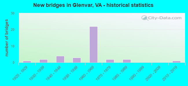
- New bridges - historical statistics
- 11920-1929
- 21930-1939
- 41940-1949
- 31950-1959
- 221960-1969
- 21970-1979
- 21980-1989
- 12010-2019

- Reconstructed bridges - Historical Statistics
- 31980-1989
- 01990-1999
- 12000-2009
- 02010-2019
- 12020-2022


- Bridge Condition - Deck
- 8.0%Very good
- 44.0%Good
- 44.0%Satisfactory
- 4.0%Fair

- Bridge Condition - Superstructure
- 8.0%Very good
- 36.0%Good
- 40.0%Satisfactory
- 16.0%Fair

- Bridge Condition - Substructure
- 40.0%Good
- 36.0%Satisfactory
- 24.0%Fair

- Bridge Condition - Channel
- 21.1%Very good
- 21.1%Good
- 57.9%Satisfactory

- Bridge Condition - Culverts
- 66.7%Good
- 33.3%Satisfactory
Find on map >> Show street view
Structure Number: 14848, Location: 2.69-Salem; 3.14-Mont Co. (Lat: 37.263850, Lng: -80.154867), Route carried "on" structure: Alternate US 11, Year Built: 1922, Status: Open, Structure Length: 1.68m (5.51ft), Average Daily Traffic: 9,190 (year 2020), Truck Traffic: 4%, Average Future Daily Traffic: 10,109 (year 2040), Design Load: HS 20, Features Intersected: Callahan Branch, Facility Carried by Structure: West Main St.(460)
Minimum Vertical Clearance: 30+ m (98+ ft), Kilometerpoint: 220.642, Lanes on structure: 4, Owner: State Highway Agency, Approaching Roadway Width: 15.2m (49.9ft), Material/Design: Concrete, Design/Construction: Tee Beam, Number Of Spans In Main Unit: 2, Length of Maximum Span: 8.0m (26.2ft), Curb or Sidewalk Widths: Left: 0.5m (1.6ft), Right: 0.5m (1.6ft), Curb-To-Curb Width: 15.8m (51.8ft), Out-to-Out Width: 18.7m (61.4ft)
Condition: Deck: Satisfactory, Superstructure: Satisfactory, Substructure: Satisfactory, Channel: Satisfactory, Operating Rating: 48.1 metric tons, Method Used To Determine Operating Rating: Load Factor (LF), Inventory Rating: 28.1 metric tons, Method Used To Determine Inventory Rating: Load Factor (LF), Structural Evaluation: Equal to present minimum criteria, Deck Geometry: Meets minimum limits, Waterway Adequacy: Better than present minimum criteria, Approach Roadway Alignment: Equal to present desirable criteria, Length Of Structure Improvement: 1.68m (5.51ft), Designated Inspection Frequency: Every 24 months, Inspection Date: November 2021, Bridge Improvement Cost: $1,781,000, Roadway Improvement Cost: $623,000, Total Project Cost: $6,146,000 ( Estimate for 2021), Deck Structure Type: Concrete Cast-file-Place, Wearing Surface/Protective System: Wearing Surface: Bituminous
Find on map >> Show street view
Structure Number: 14855, Location: 5.60-MONT CO; 1.23-RT 112 (Lat: 37.286967, Lng: -80.120658), Route carried "on" structure: Interstate 81, Year Built: 1962, Status: Open, Structure Length: 3.40m (11.15ft), Average Daily Traffic: 28,805 (year 2020), Truck Traffic: 26%, Average Future Daily Traffic: 40,327 (year 2040), Design Load: HS 20+Mod, Features Intersected: RTE 640_BUT HOLLOW ROAD
Minimum Vertical Clearance: 30+ m (98+ ft), Kilometerpoint: 219.130, Lanes on structure: 2, Lanes under structure: 2, Base Highway Network: Yes, Owner: State Highway Agency, Approaching Roadway Width: 11.9m (39.0ft), Material/Design: Concrete, Design/Construction: Tee Beam, Number Of Spans In Main Unit: 3, Length of Maximum Span: 12.2m (40.0ft), Curb-To-Curb Width: 12.8m (42.0ft), Out-to-Out Width: 13.4m (44.0ft)
Condition: Deck: Satisfactory, Superstructure: Fair, Substructure: Fair, Operating Rating: 48.1 metric tons, Method Used To Determine Operating Rating: Load and Resistance Factor (LRFR), Inventory Rating: 37.2 metric tons, Method Used To Determine Inventory Rating: Load and Resistance Factor (LRFR), Structural Evaluation: Somewhat better than minimum adequacy, Deck Geometry: Equal to present desirable criteria, Underclear: Meets minimum limits, Approach Roadway Alignment: Equal to present desirable criteria, Designated Inspection Frequency: Every 24 months, Inspection Date: July 2021, Deck Structure Type: Concrete Cast-file-Place, Wearing Surface/Protective System: Wearing Surface: Latex Concrete
Find on map >> Show street view
Structure Number: 14857, Location: 5.60-MONT CO;1.23-RT 112 (Lat: 37.287250, Lng: -80.120900), Route carried "on" structure: Interstate 81, Year Built: 1962, Status: Open, Structure Length: 3.40m (11.15ft), Average Daily Traffic: 22,319 (year 2020), Truck Traffic: 26%, Average Future Daily Traffic: 31,247 (year 2040), Design Load: HS 20+Mod, Features Intersected: RTE640; BUTT HOLLOW ROAD
Minimum Vertical Clearance: 30+ m (98+ ft), Kilometerpoint: 219.838, Lanes on structure: 2, Lanes under structure: 2, Base Highway Network: Yes, Owner: State Highway Agency, Approaching Roadway Width: 11.9m (39.0ft), Material/Design: Concrete, Design/Construction: Tee Beam, Number Of Spans In Main Unit: 3, Length of Maximum Span: 12.2m (40.0ft), Curb-To-Curb Width: 12.8m (42.0ft), Out-to-Out Width: 13.4m (44.0ft)
Condition: Deck: Satisfactory, Superstructure: Fair, Substructure: Fair, Operating Rating: 48.1 metric tons, Method Used To Determine Operating Rating: Load and Resistance Factor (LRFR), Inventory Rating: 37.2 metric tons, Method Used To Determine Inventory Rating: Load and Resistance Factor (LRFR), Structural Evaluation: Somewhat better than minimum adequacy, Deck Geometry: Equal to present desirable criteria, Underclear: Meets minimum limits, Approach Roadway Alignment: Equal to present desirable criteria, Designated Inspection Frequency: Every 24 months, Inspection Date: July 2021, Deck Structure Type: Concrete Cast-file-Place, Wearing Surface/Protective System: Wearing Surface: Latex Concrete
Find on map >> Show street view
Structure Number: 14867, Location: 5.11-MONT CO; 1.72-RT 112 (Lat: 37.282742, Lng: -80.127706), Route carried "on" structure: Interstate 81, Year Built: 1962, Year Reconstructed: 1985, Status: Open, Structure Length: 3.26m (10.70ft), Average Daily Traffic: 28,805 (year 2020), Truck Traffic: 26%, Average Future Daily Traffic: 40,327 (year 2040), Design Load: HS 20+Mod, Features Intersected: RT642; ALLEGHANNY DR.
Minimum Vertical Clearance: 30+ m (98+ ft), Kilometerpoint: 218.341, Lanes on structure: 2, Lanes under structure: 2, Base Highway Network: Yes, Owner: State Highway Agency, Approaching Roadway Width: 14.3m (46.9ft), Material/Design: Concrete, Design/Construction: Tee Beam, Number Of Spans In Main Unit: 3, Length of Maximum Span: 11.6m (38.1ft), Curb-To-Curb Width: 12.8m (42.0ft), Out-to-Out Width: 13.4m (44.0ft)
Condition: Deck: Satisfactory, Superstructure: Satisfactory, Substructure: Satisfactory, Operating Rating: 50.8 metric tons, Method Used To Determine Operating Rating: Load and Resistance Factor (LRFR), Inventory Rating: 39.0 metric tons, Method Used To Determine Inventory Rating: Load and Resistance Factor (LRFR), Structural Evaluation: Equal to present minimum criteria, Deck Geometry: Equal to present desirable criteria, Underclear: Meets minimum limits, Approach Roadway Alignment: Equal to present desirable criteria, Designated Inspection Frequency: Every 24 months, Inspection Date: August 2020, Deck Structure Type: Concrete Cast-file-Place, Wearing Surface/Protective System: Wearing Surface: Latex Concrete
Find on map >> Show street view
Structure Number: 14869, Location: 5.11 MONT CO; 1.72 RT 112 (Lat: 37.282972, Lng: -80.127928), Route carried "on" structure: Interstate 81, Year Built: 1962, Year Reconstructed: 1985, Status: Open, Structure Length: 3.26m (10.70ft), Average Daily Traffic: 22,319 (year 2020), Truck Traffic: 26%, Average Future Daily Traffic: 31,247 (year 2040), Design Load: HS 20+Mod, Features Intersected: ALLEGHANY DRIVE_(RT642)
Minimum Vertical Clearance: 30+ m (98+ ft), Kilometerpoint: 219.049, Lanes on structure: 2, Lanes under structure: 2, Base Highway Network: Yes, Owner: State Highway Agency, Approaching Roadway Width: 11.9m (39.0ft), Material/Design: Concrete, Design/Construction: Tee Beam, Number Of Spans In Main Unit: 3, Length of Maximum Span: 11.6m (38.1ft), Curb-To-Curb Width: 12.8m (42.0ft), Out-to-Out Width: 13.4m (44.0ft)
Condition: Deck: Satisfactory, Superstructure: Satisfactory, Substructure: Good, Operating Rating: 49.9 metric tons, Method Used To Determine Operating Rating: Load and Resistance Factor (LRFR), Inventory Rating: 39.0 metric tons, Method Used To Determine Inventory Rating: Load and Resistance Factor (LRFR), Structural Evaluation: Equal to present minimum criteria, Deck Geometry: Equal to present desirable criteria, Underclear: Meets minimum limits, Approach Roadway Alignment: Equal to present desirable criteria, Designated Inspection Frequency: Every 24 months, Inspection Date: August 2020, Deck Structure Type: Concrete Cast-file-Place, Wearing Surface/Protective System: Wearing Surface: Latex Concrete
Find on map >> Show street view
Structure Number: 14895, Location: 3.12-MONT CO; 3.71-RT 112 (Lat: 37.265081, Lng: -80.155661), Route carried "on" structure: Interstate 81, Year Built: 1964, Status: Open, Structure Length: 3.96m (12.99ft), Average Daily Traffic: 28,805 (year 2020), Truck Traffic: 26%, Average Future Daily Traffic: 40,327 (year 2040), Design Load: HS 20+Mod, Features Intersected: GLENVAR HEIGHTS BLVD.
Minimum Vertical Clearance: 30+ m (98+ ft), Kilometerpoint: 215.107, Lanes on structure: 2, Lanes under structure: 2, Base Highway Network: Yes, Owner: State Highway Agency, Approaching Roadway Width: 11.9m (39.0ft), Skew: 1 degrees, Material/Design: Concrete, Design/Construction: Tee Beam, Number Of Spans In Main Unit: 3, Length of Maximum Span: 12.4m (40.7ft), Curb-To-Curb Width: 12.8m (42.0ft), Out-to-Out Width: 13.4m (44.0ft)
Condition: Deck: Good, Superstructure: Fair, Substructure: Fair, Operating Rating: 55.3 metric tons, Method Used To Determine Operating Rating: Load and Resistance Factor (LRFR), Inventory Rating: 42.6 metric tons, Method Used To Determine Inventory Rating: Load and Resistance Factor (LRFR), Structural Evaluation: Somewhat better than minimum adequacy, Deck Geometry: Equal to present desirable criteria, Underclear: Somewhat better than minimum adequacy, Approach Roadway Alignment: Equal to present desirable criteria, Length Of Structure Improvement: 3.96m (12.99ft), Designated Inspection Frequency: Every 24 months, Inspection Date: July 2021, Bridge Improvement Cost: $200,000, Roadway Improvement Cost: $1,000, Total Project Cost: $234,000 ( Estimate for 2021), Deck Structure Type: Concrete Cast-file-Place, Wearing Surface/Protective System: Wearing Surface: Latex Concrete
Find on map >> Show street view
Structure Number: 14897, Location: 3.12-MONT CO; 3.71-RT 112 (Lat: 37.265261, Lng: -80.155881), Route carried "on" structure: Interstate 81, Year Built: 1964, Status: Open, Structure Length: 4.14m (13.58ft), Average Daily Traffic: 22,319 (year 2020), Truck Traffic: 26%, Average Future Daily Traffic: 31,247 (year 2040), Design Load: HS 20+Mod, Features Intersected: GLENVAR HEIGHTS BLVD
Minimum Vertical Clearance: 30+ m (98+ ft), Kilometerpoint: 215.815, Lanes on structure: 2, Lanes under structure: 2, Base Highway Network: Yes, Owner: State Highway Agency, Approaching Roadway Width: 6.2m (20.3ft), Skew: 1 degrees, Material/Design: Concrete, Design/Construction: Tee Beam, Number Of Spans In Main Unit: 3, Length of Maximum Span: 13.4m (44.0ft), Curb-To-Curb Width: 12.8m (42.0ft), Out-to-Out Width: 13.4m (44.0ft)
Condition: Deck: Good, Superstructure: Satisfactory, Substructure: Fair, Operating Rating: 51.7 metric tons, Method Used To Determine Operating Rating: Load and Resistance Factor (LRFR), Inventory Rating: 39.9 metric tons, Method Used To Determine Inventory Rating: Load and Resistance Factor (LRFR), Structural Evaluation: Somewhat better than minimum adequacy, Deck Geometry: Equal to present desirable criteria, Underclear: Somewhat better than minimum adequacy, Approach Roadway Alignment: Equal to present desirable criteria, Length Of Structure Improvement: 4.15m (13.62ft), Designated Inspection Frequency: Every 24 months, Inspection Date: July 2021, Bridge Improvement Cost: $200,000, Total Project Cost: $206,000 ( Estimate for 2041), Deck Structure Type: Concrete Cast-file-Place, Wearing Surface/Protective System: Wearing Surface: Latex Concrete
Find on map >> Show street view
Structure Number: 14899, Location: 4.19 MONT CO; 2.64 RT 112 (Lat: 37.273931, Lng: -80.140150), Route carried "on" structure: Interstate 81, Year Built: 1964, Status: Open, Structure Length: 4.66m (15.29ft), Average Daily Traffic: 28,805 (year 2020), Truck Traffic: 26%, Average Future Daily Traffic: 40,327 (year 2040), Design Load: HS 20+Mod, Features Intersected: 777 FORT LEWIS CHURCH RD
Minimum Vertical Clearance: 30+ m (98+ ft), Kilometerpoint: 216.829, Lanes on structure: 2, Lanes under structure: 2, Base Highway Network: Yes, Owner: State Highway Agency, Approaching Roadway Width: 11.9m (39.0ft), Skew: 4 degrees, Material/Design: Steel, Design/Construction: Stringer/Multi-beam, Number Of Spans In Main Unit: 3, Length of Maximum Span: 15.2m (49.9ft), Curb-To-Curb Width: 12.8m (42.0ft), Out-to-Out Width: 13.4m (44.0ft)
Condition: Deck: Satisfactory, Superstructure: Satisfactory, Substructure: Fair, Operating Rating: 61.7 metric tons, Method Used To Determine Operating Rating: Load and Resistance Factor (LRFR), Inventory Rating: 47.2 metric tons, Method Used To Determine Inventory Rating: Load and Resistance Factor (LRFR), Structural Evaluation: Somewhat better than minimum adequacy, Deck Geometry: Equal to present desirable criteria, Underclear: Meets minimum limits, Approach Roadway Alignment: Equal to present desirable criteria, Length Of Structure Improvement: 4.66m (15.29ft), Designated Inspection Frequency: Every 24 months, Inspection Date: August 2021, Bridge Improvement Cost: $2,079,000, Roadway Improvement Cost: $728,000, Total Project Cost: $6,757,000 ( Estimate for 2015), Deck Structure Type: Concrete Cast-file-Place, Wearing Surface/Protective System: Wearing Surface: Latex Concrete
Find on map >> Show street view
Structure Number: 14901, Location: 4.19-MONT CO; 2.64-RT 112 (Lat: 37.274158, Lng: -80.140231), Route carried "on" structure: Interstate 81, Year Built: 1964, Status: Open, Structure Length: 4.66m (15.29ft), Average Daily Traffic: 22,319 (year 2020), Truck Traffic: 24%, Average Future Daily Traffic: 31,247 (year 2040), Design Load: HS 20+Mod, Features Intersected: 777 FORT LEWIS CHURCH RD
Minimum Vertical Clearance: 30+ m (98+ ft), Kilometerpoint: 217.537, Lanes on structure: 2, Lanes under structure: 2, Base Highway Network: Yes, Owner: State Highway Agency, Approaching Roadway Width: 11.9m (39.0ft), Skew: 4 degrees, Material/Design: Steel, Design/Construction: Stringer/Multi-beam, Number Of Spans In Main Unit: 3, Length of Maximum Span: 15.2m (49.9ft), Curb-To-Curb Width: 12.8m (42.0ft), Out-to-Out Width: 13.4m (44.0ft)
Condition: Deck: Satisfactory, Superstructure: Satisfactory, Substructure: Fair, Operating Rating: 61.7 metric tons, Method Used To Determine Operating Rating: Load and Resistance Factor (LRFR), Inventory Rating: 48.1 metric tons, Method Used To Determine Inventory Rating: Load and Resistance Factor (LRFR), Structural Evaluation: Somewhat better than minimum adequacy, Deck Geometry: Equal to present desirable criteria, Underclear: Meets minimum limits, Approach Roadway Alignment: Equal to present desirable criteria, Designated Inspection Frequency: Every 24 months, Inspection Date: August 2021, Deck Structure Type: Concrete Cast-file-Place, Wearing Surface/Protective System: Wearing Surface: Latex Concrete
Find on map >> Show street view
Structure Number: 14904, Location: 4.22-Mont Co; 2.61-Rte112 (Lat: 37.274522, Lng: -80.139675), Route carried "on" structure: Interstate 81, Year Built: 1964, Status: Open, Structure Length: 1.16m (3.81ft), Average Daily Traffic: 51,124 (year 2020), Truck Traffic: 26%, Average Future Daily Traffic: 57,401 (year 2040), Design Load: HS 20, Features Intersected: Rock Branch
Minimum Vertical Clearance: 30+ m (98+ ft), Kilometerpoint: 216.909, Lanes on structure: 4, Base Highway Network: Yes, Owner: State Highway Agency, Approaching Roadway Width: 14.3m (46.9ft), Skew: 23 degrees, Material/Design: Concrete, Design/Construction: Culvert, Number Of Spans In Main Unit: 3, Length of Maximum Span: 3.0m (9.8ft)
Condition: Channel: Satisfactory, Culverts: Satisfactory, Operating Rating: 54.4 metric tons, Method Used To Determine Operating Rating: Load Factor (LF), Inventory Rating: 32.7 metric tons, Method Used To Determine Inventory Rating: Load Factor (LF), Structural Evaluation: Equal to present minimum criteria, Waterway Adequacy: Equal to present minimum criteria, Approach Roadway Alignment: Equal to present desirable criteria, Length Of Structure Improvement: 1.16m (3.81ft), Designated Inspection Frequency: Every 24 months, Inspection Date: April 2021, Bridge Improvement Cost: $617,000, Roadway Improvement Cost: $216,000, Total Project Cost: $1,819,000 ( Estimate for 2017)
Find on map >> Show street view
Structure Number: 14982, Location: 0.70-Rt639S; 0.30-Rt639N (Lat: 37.252800, Lng: -80.134400), Route carried "on" structure: County highway 612, Year Built: 1949, Year Reconstructed: 2012, Status: Open, Structure Length: 0.77m (2.53ft), Average Daily Traffic: 715 (year 2018), Average Future Daily Traffic: 899 (year 2040), Features Intersected: Branch Roanoke River
Minimum Vertical Clearance: 30+ m (98+ ft), Kilometerpoint: 1.812, Lanes on structure: 2, Owner: State Highway Agency, Approaching Roadway Width: 6.1m (20.0ft), Material/Design: Prestressed concrete, Design/Construction: Slab, Number Of Spans In Main Unit: 1, Length of Maximum Span: 7.7m (25.3ft), Curb-To-Curb Width: 6.2m (20.3ft), Out-to-Out Width: 6.4m (21.0ft)
Condition: Deck: Good, Superstructure: Good, Substructure: Satisfactory, Channel: Satisfactory, Operating Rating: 65.3 metric tons, Method Used To Determine Operating Rating: Load and Resistance Factor (LRFR), Inventory Rating: 50.8 metric tons, Method Used To Determine Inventory Rating: Load and Resistance Factor (LRFR), Structural Evaluation: Equal to present minimum criteria, Deck Geometry: High priority of corrective action, Waterway Adequacy: Better than present minimum criteria, Approach Roadway Alignment: Equal to present minimum criteria, Length Of Structure Improvement: 0.67m (2.20ft), Designated Inspection Frequency: Every 24 months, Inspection Date: October 2020, Bridge Improvement Cost: $1,000, Roadway Improvement Cost: $1,000, Total Project Cost: $3,000 ( Estimate for 2020), Deck Structure Type: Concrete Precast Panels, Wearing Surface/Protective System: Wearing Surface: Bituminous, Membrane: Other
Find on map >> Show street view
Structure Number: 14983, Location: 0.77-Rte639N; 0.13-Rte646 (Lat: 37.264511, Lng: -80.138922), Route carried "on" structure: County highway 612, Year Built: 1932, Status: Open, Structure Length: 1.10m (3.61ft), Average Daily Traffic: 852 (year 2020), Truck Traffic: 2%, Average Future Daily Traffic: 937 (year 2040), Features Intersected: Callahan Branch @ Wabun
Minimum Vertical Clearance: 30+ m (98+ ft), Kilometerpoint: 0.537, Lanes on structure: 1, Owner: State Highway Agency, Approaching Roadway Width: 6.1m (20.0ft), Material/Design: Concrete, Design/Construction: Girder and Floorbeam System, Number Of Spans In Main Unit: 1, Length of Maximum Span: 11.0m (36.1ft), Curb or Sidewalk Widths: Left: 0.1m (0.3ft), Right: 0.1m (0.3ft), Curb-To-Curb Width: 4.6m (15.1ft), Out-to-Out Width: 5.9m (19.4ft)
Condition: Deck: Satisfactory, Superstructure: Satisfactory, Substructure: Good, Channel: Very good, Operating Rating: 54.4 metric tons, Method Used To Determine Operating Rating: Field evaluation and documented engineering judgment, Inventory Rating: 32.7 metric tons, Method Used To Determine Inventory Rating: Field evaluation and documented engineering judgment, Structural Evaluation: Equal to present minimum criteria, Deck Geometry: High priority of replacement, Waterway Adequacy: Equal to present minimum criteria, Approach Roadway Alignment: Equal to present desirable criteria, Length Of Structure Improvement: 1.10m (3.61ft), Designated Inspection Frequency: Every 24 months, Inspection Date: June 2021, Bridge Improvement Cost: $274,000, Roadway Improvement Cost: $96,000, Total Project Cost: $891,000 ( Estimate for 2021), Deck Structure Type: Concrete Cast-file-Place, Wearing Surface/Protective System: Wearing Surface: Bituminous
Find on map >> Show street view
Structure Number: 14984, Location: 4.55-Rte916; 0.55-Rte639 (Lat: 37.234189, Lng: -80.133375), Route carried "on" structure: County highway 612, Year Built: 1951, Status: Open, Structure Length: 0.76m (2.49ft), Average Daily Traffic: 320 (year 2018), Average Future Daily Traffic: 371 (year 2040), Design Load: HS 20+Mod, Features Intersected: Br Roanoke River
Minimum Vertical Clearance: 30+ m (98+ ft), Kilometerpoint: 4.869, Lanes on structure: 2, Owner: State Highway Agency, Approaching Roadway Width: 5.2m (17.1ft), Skew: 3 degrees, Material/Design: Steel, Design/Construction: Stringer/Multi-beam, Number Of Spans In Main Unit: 1, Length of Maximum Span: 7.6m (24.9ft), Curb-To-Curb Width: 6.0m (19.7ft), Out-to-Out Width: 6.4m (21.0ft)
Condition: Deck: Good, Superstructure: Good, Substructure: Good, Channel: Satisfactory, Operating Rating: 78.0 metric tons, Method Used To Determine Operating Rating: Load and Resistance Factor (LRFR), Inventory Rating: 59.9 metric tons, Method Used To Determine Inventory Rating: Load and Resistance Factor (LRFR), Structural Evaluation: Better than present minimum criteria, Deck Geometry: High priority of corrective action, Waterway Adequacy: Equal to present desirable criteria, Approach Roadway Alignment: Equal to present minimum criteria, Length Of Structure Improvement: 0.76m (2.49ft), Designated Inspection Frequency: Every 24 months, Inspection Date: August 2021, Bridge Improvement Cost: $289,000, Roadway Improvement Cost: $12,000, Total Project Cost: $302,000, Deck Structure Type: Wood or Timber, Wearing Surface/Protective System: Wearing Surface: Bituminous
Find on map >> Show street view
Structure Number: 14985, Location: 1.00-Rte639; 4.10-Rte916 (Lat: 37.228636, Lng: -80.133231), Route carried "on" structure: County highway 612, Year Built: 1951, Status: Open, Structure Length: 0.76m (2.49ft), Average Daily Traffic: 320 (year 2018), Average Future Daily Traffic: 371 (year 2040), Features Intersected: Dry Branch
Minimum Vertical Clearance: 30+ m (98+ ft), Kilometerpoint: 5.593, Lanes on structure: 2, Owner: State Highway Agency, Approaching Roadway Width: 3.8m (12.5ft), Skew: 1 degrees, Material/Design: Steel, Design/Construction: Stringer/Multi-beam, Number Of Spans In Main Unit: 1, Length of Maximum Span: 7.6m (24.9ft), Curb or Sidewalk Widths: Left: 0.2m (0.7ft), Right: 0.2m (0.7ft), Curb-To-Curb Width: 5.7m (18.7ft), Out-to-Out Width: 7.4m (24.3ft)
Condition: Deck: Very good, Superstructure: Very good, Substructure: Satisfactory, Channel: Satisfactory, Operating Rating: 79.8 metric tons, Method Used To Determine Operating Rating: Load and Resistance Factor (LRFR), Inventory Rating: 61.7 metric tons, Method Used To Determine Inventory Rating: Load and Resistance Factor (LRFR), Structural Evaluation: Equal to present minimum criteria, Deck Geometry: High priority of corrective action, Waterway Adequacy: Somewhat better than minimum adequacy, Approach Roadway Alignment: Equal to present minimum criteria, Length Of Structure Improvement: 0.76m (2.49ft), Designated Inspection Frequency: Every 24 months, Inspection Date: August 2020, Bridge Improvement Cost: $234,000, Roadway Improvement Cost: $82,000, Total Project Cost: $762,000 ( Estimate for 2018), Deck Structure Type: Wood or Timber, Wearing Surface/Protective System: Wearing Surface: Bituminous
Find on map >> Show street view
Structure Number: 14989, Location: 0.01-Rte639; 1.00-Rte646 (Lat: 37.255278, Lng: -80.137539), Route carried "on" structure: County highway 612, Year Built: 1962, Status: Open, Structure Length: 6.25m (20.51ft), Average Daily Traffic: 852 (year 2020), Truck Traffic: 2%, Average Future Daily Traffic: 937 (year 2040), Design Load: HS 15, Features Intersected: Roanoke River
Minimum Vertical Clearance: 30+ m (98+ ft), Kilometerpoint: 1.709, Lanes on structure: 2, Owner: State Highway Agency, Approaching Roadway Width: 6.7m (22.0ft), Skew: 2 degrees, Material/Design: Steel, Design/Construction: Stringer/Multi-beam, Number Of Spans In Main Unit: 3, Length of Maximum Span: 21.0m (68.9ft), Curb or Sidewalk Widths: Left: 0.5m (1.6ft), Right: 0.5m (1.6ft), Curb-To-Curb Width: 8.3m (27.2ft), Out-to-Out Width: 9.9m (32.5ft)
Condition: Deck: Satisfactory, Superstructure: Satisfactory, Substructure: Good, Channel: Satisfactory, Operating Rating: 58.1 metric tons, Method Used To Determine Operating Rating: Load and Resistance Factor (LRFR), Inventory Rating: 44.5 metric tons, Method Used To Determine Inventory Rating: Load and Resistance Factor (LRFR), Structural Evaluation: Equal to present minimum criteria, Deck Geometry: Somewhat better than minimum adequacy, Waterway Adequacy: Equal to present minimum criteria, Approach Roadway Alignment: Equal to present minimum criteria, Length Of Structure Improvement: 6.40m (21.00ft), Designated Inspection Frequency: Every 24 months, Underwater Inspection Frequency: Every 60 months, Inspection Date: May 2020, Underwater Inspection Date: June 2017, Bridge Improvement Cost: $2,296,000, Roadway Improvement Cost: $804,000, Total Project Cost: $7,463,000 ( Estimate for 2015), Deck Structure Type: Concrete Cast-file-Place, Wearing Surface/Protective System: Wearing Surface: Epoxy Overlay, Deck Protection: Other
Find on map >> Show street view
Structure Number: 15038, Location: 0.34-Rte734; 1.80-Rte649 (Lat: 37.244208, Lng: -80.143947), Route carried "on" structure: County highway 639, Year Built: 1974, Status: Open, Structure Length: 5.52m (18.11ft), Average Daily Traffic: 228 (year 2020), Truck Traffic: 4%, Average Future Daily Traffic: 251 (year 2040), Design Load: HS 20+Mod, Features Intersected: Roanoke River
Minimum Vertical Clearance: 30+ m (98+ ft), Kilometerpoint: 3.041, Lanes on structure: 2, Owner: State Highway Agency, Approaching Roadway Width: 6.7m (22.0ft), Skew: 2 degrees, Material/Design: Concrete, Design/Construction: Slab, Number Of Spans In Main Unit: 4, Length of Maximum Span: 15.2m (49.9ft), Curb-To-Curb Width: 9.1m (29.9ft), Out-to-Out Width: 10.0m (32.8ft)
Condition: Deck: Good, Superstructure: Good, Substructure: Satisfactory, Channel: Satisfactory, Operating Rating: 52.6 metric tons, Method Used To Determine Operating Rating: Load and Resistance Factor (LRFR), Inventory Rating: 40.8 metric tons, Method Used To Determine Inventory Rating: Load and Resistance Factor (LRFR), Structural Evaluation: Equal to present minimum criteria, Deck Geometry: Equal to present minimum criteria, Waterway Adequacy: Equal to present minimum criteria, Approach Roadway Alignment: Equal to present desirable criteria, Designated Inspection Frequency: Every 24 months, Inspection Date: April 2020, Deck Structure Type: Concrete Cast-file-Place, Wearing Surface/Protective System: Wearing Surface: Epoxy Overlay
Find on map >> Show street view
Structure Number: 15041, Location: 0.75-RT 734; 0.90-RT 649 (Lat: 37.245228, Lng: -80.150558), Route carried "on" structure: County highway 639, Year Built: 1989, Status: Open, Structure Length: 15.02m (49.28ft), Average Daily Traffic: 228 (year 2020), Truck Traffic: 4%, Average Future Daily Traffic: 251 (year 2040), Design Load: HS 20+Mod, Features Intersected: ROANOKE RIVER
Minimum Vertical Clearance: 30+ m (98+ ft), Kilometerpoint: 2.816, Lanes on structure: 2, Owner: State Highway Agency, Approaching Roadway Width: 6.7m (22.0ft), Skew: 4 degrees, Material/Design: Steel, Design/Construction: Stringer/Multi-beam, Number Of Spans In Main Unit: 7, Length of Maximum Span: 21.3m (69.9ft), Curb-To-Curb Width: 9.8m (32.2ft), Out-to-Out Width: 10.8m (35.4ft)
Condition: Deck: Good, Superstructure: Good, Substructure: Good, Channel: Satisfactory, Operating Rating: 44.5 metric tons, Method Used To Determine Operating Rating: Load and Resistance Factor (LRFR), Inventory Rating: 34.5 metric tons, Method Used To Determine Inventory Rating: Load and Resistance Factor (LRFR), Structural Evaluation: Better than present minimum criteria, Deck Geometry: Better than present minimum criteria, Waterway Adequacy: Equal to present desirable criteria, Approach Roadway Alignment: Equal to present desirable criteria, Designated Inspection Frequency: Every 24 months, Inspection Date: October 2021, Deck Structure Type: Concrete Cast-file-Place, Wearing Surface/Protective System: Deck Protection: Epoxy Coated Reinforcing
Find on map >> Show street view
Structure Number: 15046, Location: 0.10-Rte737; 1.55-Rte882 (Lat: 37.250308, Lng: -80.104969), Route carried "on" structure: County highway 639, Year Built: 1949, Status: Open, Structure Length: 1.07m (3.51ft), Average Daily Traffic: 702 (year 2018), Average Future Daily Traffic: 1,011 (year 2040), Design Load: HL 93, Features Intersected: Br Roanoke River
Minimum Vertical Clearance: 30+ m (98+ ft), Kilometerpoint: 9.532, Lanes on structure: 2, Owner: State Highway Agency, Approaching Roadway Width: 5.5m (18.0ft), Skew: 4 degrees, Material/Design: Steel, Design/Construction: Stringer/Multi-beam, Number Of Spans In Main Unit: 1, Length of Maximum Span: 10.4m (34.1ft), Curb-To-Curb Width: 6.1m (20.0ft), Out-to-Out Width: 6.9m (22.6ft)
Condition: Deck: Very good, Superstructure: Very good, Substructure: Good, Channel: Very good, Operating Rating: 58.1 metric tons, Method Used To Determine Operating Rating: Load and Resistance Factor (LRFR), Inventory Rating: 44.5 metric tons, Method Used To Determine Inventory Rating: Load and Resistance Factor (LRFR), Structural Evaluation: Better than present minimum criteria, Deck Geometry: High priority of corrective action, Waterway Adequacy: Equal to present minimum criteria, Approach Roadway Alignment: Better than present minimum criteria, Length Of Structure Improvement: 1.07m (3.51ft), Designated Inspection Frequency: Every 24 months, Inspection Date: August 2020, Bridge Improvement Cost: $393,000, Roadway Improvement Cost: $138,000, Total Project Cost: $1,278,000 ( Estimate for 2016), Deck Structure Type: Wood or Timber, Wearing Surface/Protective System: Wearing Surface: Bituminous, Membrane: Other
Find on map >> Show street view
Structure Number: 15049, Location: 0.30-RT11; 0.01-RT828 (Lat: 37.279958, Lng: -80.131911), Route carried "on" structure: County highway 643, Year Built: 1962, Year Reconstructed: 1993, Status: Open, Structure Length: 7.44m (24.41ft), Average Daily Traffic: 3,393 (year 2019), Average Future Daily Traffic: 3,749 (year 2040), Design Load: HL 93, Features Intersected: RTE 81
Minimum Vertical Clearance: 30+ m (98+ ft), Kilometerpoint: 0.483, Lanes on structure: 2, Lanes under structure: 4, Owner: State Highway Agency, Approaching Roadway Width: 5.5m (18.0ft), Skew: 1 degrees, Material/Design: Steel, Design/Construction: Stringer/Multi-beam, Number Of Spans In Main Unit: 4, Length of Maximum Span: 24.1m (79.1ft), Curb or Sidewalk Widths: Left: 0.5m (1.6ft), Right: 0.5m (1.6ft), Curb-To-Curb Width: 7.3m (24.0ft), Out-to-Out Width: 8.9m (29.2ft)
Condition: Deck: Good, Superstructure: Satisfactory, Substructure: Satisfactory, Operating Rating: 42.6 metric tons, Method Used To Determine Operating Rating: Load and Resistance Factor (LRFR), Inventory Rating: 32.7 metric tons, Method Used To Determine Inventory Rating: Load and Resistance Factor (LRFR), Structural Evaluation: Equal to present minimum criteria, Deck Geometry: High priority of replacement, Underclear: Somewhat better than minimum adequacy, Approach Roadway Alignment: Equal to present desirable criteria, Length Of Structure Improvement: 7.44m (24.41ft), Designated Inspection Frequency: Every 24 months, Inspection Date: September 2020, Bridge Improvement Cost: $5,077,000, Roadway Improvement Cost: $1,269,000, Total Project Cost: $16,246,000 ( Estimate for 2019), Deck Structure Type: Concrete Cast-file-Place, Wearing Surface/Protective System: Wearing Surface: Latex Concrete
Find on map >> Show street view
Structure Number: 15051, Location: 0.00-RTE 612;0.10-RTE 852 (Lat: 37.267289, Lng: -80.139617), Route carried "on" structure: County highway 646, Year Built: 1978, Status: Open, Structure Length: 6.00m (19.69ft), Average Daily Traffic: 780 (year 2019), Truck Traffic: 5%, Average Future Daily Traffic: 1,108 (year 2040), Design Load: HL 93, Features Intersected: ROANOKE RIVER
Minimum Vertical Clearance: 30+ m (98+ ft), Kilometerpoint: 0.016, Lanes on structure: 2, Owner: State Highway Agency, Approaching Roadway Width: 6.7m (22.0ft), Material/Design: Steel, Design/Construction: Stringer/Multi-beam, Number Of Spans In Main Unit: 3, Length of Maximum Span: 20.1m (65.9ft), Curb or Sidewalk Widths: Left: 0.4m (1.3ft), Right: 0.4m (1.3ft), Curb-To-Curb Width: 7.9m (25.9ft), Out-to-Out Width: 9.1m (29.9ft)
Condition: Deck: Satisfactory, Superstructure: Good, Substructure: Satisfactory, Channel: Good, Operating Rating: 76.2 metric tons, Method Used To Determine Operating Rating: Load and Resistance Factor (LRFR), Inventory Rating: 59.0 metric tons, Method Used To Determine Inventory Rating: Load and Resistance Factor (LRFR), Structural Evaluation: Equal to present minimum criteria, Deck Geometry: Somewhat better than minimum adequacy, Waterway Adequacy: Equal to present desirable criteria, Approach Roadway Alignment: Equal to present desirable criteria, Designated Inspection Frequency: Every 24 months, Inspection Date: Febuary 2021, Deck Structure Type: Concrete Cast-file-Place, Wearing Surface/Protective System: Wearing Surface: Epoxy Overlay
Find on map >> Show street view
Structure Number: 15092, Location: 0.02-Rte871; 0.01-Rte639 (Lat: 37.249622, Lng: -80.141722), Route carried "on" structure: County highway 734, Year Built: 1948, Status: Posted for load, Structure Length: 4.42m (14.50ft), Average Daily Traffic: 160 (year 2018), Average Future Daily Traffic: 188 (year 2040), Features Intersected: Roanoke River
Minimum Vertical Clearance: 30+ m (98+ ft), Kilometerpoint: 0.064, Lanes on structure: 1, Owner: State Highway Agency, Approaching Roadway Width: 3.7m (12.1ft), Material/Design: Steel, Design/Construction: Stringer/Multi-beam, Number Of Spans In Main Unit: 3, Length of Maximum Span: 16.5m (54.1ft), Curb or Sidewalk Widths: Left: 0.2m (0.7ft), Right: 0.2m (0.7ft), Curb-To-Curb Width: 3.4m (11.2ft), Out-to-Out Width: 3.7m (12.1ft)
Condition: Deck: Satisfactory, Superstructure: Satisfactory, Substructure: Satisfactory, Channel: Satisfactory, Operating Rating: 36.3 metric tons, Method Used To Determine Operating Rating: Load Factor (LF), Inventory Rating: 21.8 metric tons, Method Used To Determine Inventory Rating: Load Factor (LF), Structural Evaluation: Equal to present minimum criteria, Deck Geometry: High priority of replacement, Waterway Adequacy: Somewhat better than minimum adequacy, Approach Roadway Alignment: Equal to present desirable criteria, Bridge Posting: Required (Relationship of Operating Rating to Maximum Legal Load: 10.0 - 19.9% below), Length Of Structure Improvement: 5.03m (16.50ft), Designated Inspection Frequency: Every 12 months, Inspection Date: June 2021, Bridge Improvement Cost: $841,000, Roadway Improvement Cost: $294,000, Total Project Cost: $2,733,000 ( Estimate for 2021), Deck Structure Type: Concrete Cast-file-Place, Wearing Surface/Protective System: Wearing Surface: Other
Find on map >> Show street view
Structure Number: 15094, Location: 0.00-Rte639;0.80-end main (Lat: 37.249289, Lng: -80.105294), Route carried "on" structure: County highway 737, Year Built: 1957, Status: Open, Structure Length: 0.69m (2.26ft), Average Daily Traffic: 327 (year 2018), Average Future Daily Traffic: 404 (year 2040), Design Load: HS 20+Mod, Features Intersected: Branch Roanoke River
Minimum Vertical Clearance: 30+ m (98+ ft), Kilometerpoint: 1.265, Lanes on structure: 2, Owner: State Highway Agency, Approaching Roadway Width: 5.5m (18.0ft), Material/Design: Concrete, Design/Construction: Slab, Number Of Spans In Main Unit: 1, Length of Maximum Span: 6.9m (22.6ft), Curb-To-Curb Width: 6.0m (19.7ft), Out-to-Out Width: 6.2m (20.3ft)
Condition: Deck: Good, Superstructure: Good, Substructure: Good, Channel: Satisfactory, Operating Rating: 82.6 metric tons, Method Used To Determine Operating Rating: Load and Resistance Factor (LRFR), Inventory Rating: 63.5 metric tons, Method Used To Determine Inventory Rating: Load and Resistance Factor (LRFR), Structural Evaluation: Better than present minimum criteria, Deck Geometry: High priority of corrective action, Waterway Adequacy: Equal to present minimum criteria, Approach Roadway Alignment: Equal to present desirable criteria, Length Of Structure Improvement: 0.70m (2.30ft), Designated Inspection Frequency: Every 19 months, Inspection Date: August 2020, Bridge Improvement Cost: $395,000, Roadway Improvement Cost: $2,000, Total Project Cost: $398,000, Deck Structure Type: Concrete Precast Panels, Wearing Surface/Protective System: Wearing Surface: Bituminous, Membrane: Epoxy
Find on map >> Show street view
Structure Number: 15109, Location: 0.28 RT 793; 0.02 RT 828 (Lat: 37.275267, Lng: -80.140450), Route carried "on" structure: County highway 777, Year Built: 1944, Status: Posted for load, Structure Length: 0.82m (2.69ft), Average Daily Traffic: 2,281 (year 2018), Average Future Daily Traffic: 2,661 (year 2040), Features Intersected: Stypes Branch
Minimum Vertical Clearance: 30+ m (98+ ft), Kilometerpoint: 0.418, Lanes on structure: 2, Owner: State Highway Agency, Approaching Roadway Width: 6.7m (22.0ft), Skew: 4 degrees, Material/Design: Steel, Design/Construction: Stringer/Multi-beam, Number Of Spans In Main Unit: 1, Length of Maximum Span: 8.2m (26.9ft), Curb-To-Curb Width: 6.1m (20.0ft), Out-to-Out Width: 6.5m (21.3ft)
Condition: Deck: Fair, Superstructure: Fair, Substructure: Good, Channel: Good, Operating Rating: 34.5 metric tons, Method Used To Determine Operating Rating: Load and Resistance Factor (LRFR), Inventory Rating: 26.3 metric tons, Method Used To Determine Inventory Rating: Load and Resistance Factor (LRFR), Structural Evaluation: Somewhat better than minimum adequacy, Deck Geometry: High priority of replacement, Waterway Adequacy: Somewhat better than minimum adequacy, Approach Roadway Alignment: Equal to present desirable criteria, Bridge Posting: Required (Relationship of Operating Rating to Maximum Legal Load: 0.1 - 9.9% below), Length Of Structure Improvement: 0.82m (2.69ft), Designated Inspection Frequency: Every 24 months, Inspection Date: May 2020, Bridge Improvement Cost: $350,000, Roadway Improvement Cost: $122,000, Total Project Cost: $1,137,000 ( Estimate for 2018), Deck Structure Type: Wood or Timber, Wearing Surface/Protective System: Wearing Surface: Bituminous
Find on map >> Show street view
Structure Number: 1511, Location: 0.06-Rte828; 0.15-Rte11 (Lat: 37.273658, Lng: -80.139836), Route carried "on" structure: County highway 777, Year Built: 1964, Status: Open, Structure Length: 1.34m (4.40ft), Average Daily Traffic: 2,281 (year 2018), Average Future Daily Traffic: 2,661 (year 2040), Design Load: HS 20, Features Intersected: STYPES BRANCH
Minimum Vertical Clearance: 30+ m (98+ ft), Kilometerpoint: 0.290, Lanes on structure: 2, Owner: State Highway Agency, Approaching Roadway Width: 7.3m (24.0ft), Skew: 4 degrees, Material/Design: Concrete, Design/Construction: Culvert, Number Of Spans In Main Unit: 3, Length of Maximum Span: 3.0m (9.8ft)
Condition: Channel: Very good, Culverts: Good, Operating Rating: 54.4 metric tons, Method Used To Determine Operating Rating: Field evaluation and documented engineering judgment, Inventory Rating: 32.7 metric tons, Method Used To Determine Inventory Rating: Field evaluation and documented engineering judgment, Structural Evaluation: Better than present minimum criteria, Waterway Adequacy: Meets minimum limits, Approach Roadway Alignment: Equal to present desirable criteria, Designated Inspection Frequency: Every 24 months, Inspection Date: April 2021
Find on map >> Show street view
Structure Number: 15123, Location: 0.40-Rte1119; 0.0-Rte777 (Lat: 37.275106, Lng: -80.140244), Route carried "on" structure: County highway 828, Year Built: 1932, Status: Open, Structure Length: 0.79m (2.59ft), Average Daily Traffic: 822 (year 2019), Average Future Daily Traffic: 1,009 (year 2040), Features Intersected: Little Bear Rock Branch
Minimum Vertical Clearance: 30+ m (98+ ft), Kilometerpoint: 0.016, Lanes on structure: 2, Owner: State Highway Agency, Approaching Roadway Width: 5.5m (18.0ft), Material/Design: Steel, Design/Construction: Stringer/Multi-beam, Number Of Spans In Main Unit: 1, Length of Maximum Span: 7.9m (25.9ft), Curb or Sidewalk Widths: Left: 0.2m (0.7ft), Right: 0.2m (0.7ft), Curb-To-Curb Width: 5.9m (19.4ft), Out-to-Out Width: 6.2m (20.3ft)
Condition: Deck: Good, Superstructure: Good, Substructure: Satisfactory, Channel: Satisfactory, Operating Rating: 86.2 metric tons, Method Used To Determine Operating Rating: Load and Resistance Factor (LRFR), Inventory Rating: 66.2 metric tons, Method Used To Determine Inventory Rating: Load and Resistance Factor (LRFR), Structural Evaluation: Equal to present minimum criteria, Deck Geometry: High priority of replacement, Waterway Adequacy: Equal to present minimum criteria, Approach Roadway Alignment: Equal to present desirable criteria, Length Of Structure Improvement: 1.22m (4.00ft), Designated Inspection Frequency: Every 24 months, Inspection Date: March 2021, Bridge Improvement Cost: $290,000, Roadway Improvement Cost: $102,000, Total Project Cost: $943,000 ( Estimate for 2019), Deck Structure Type: Wood or Timber, Wearing Surface/Protective System: Wearing Surface: Bituminous, Membrane: Other
Find on map >> Show street view
Structure Number: 15125, Location: 0.02-Rt847; 0.18-dead end (Lat: 37.255636, Lng: -80.136653), Route carried "on" structure: County highway 857, Year Built: 1961, Year Reconstructed: 2020, Status: Open, Structure Length: 0.82m (2.69ft), Average Daily Traffic: 15 (year 2015), Average Future Daily Traffic: 22 (year 2040), Design Load: HL 93, Features Intersected: Dry Branch
Minimum Vertical Clearance: 30+ m (98+ ft), Kilometerpoint: 0.097, Lanes on structure: 1, Owner: State Highway Agency, Approaching Roadway Width: 3.0m (9.8ft), Material/Design: Concrete, Design/Construction: Slab, Number Of Spans In Main Unit: 1, Length of Maximum Span: 8.2m (26.9ft), Curb or Sidewalk Widths: Left: 0.1m (0.3ft), Right: 0.1m (0.3ft), Curb-To-Curb Width: 4.0m (13.1ft), Out-to-Out Width: 4.2m (13.8ft)
Condition: Deck: Good, Superstructure: Good, Substructure: Good, Channel: Very good, Operating Rating: 68.0 metric tons, Method Used To Determine Operating Rating: Load and Resistance Factor (LRFR), Inventory Rating: 51.7 metric tons, Method Used To Determine Inventory Rating: Load and Resistance Factor (LRFR), Structural Evaluation: Better than present minimum criteria, Deck Geometry: Somewhat better than minimum adequacy, Waterway Adequacy: Somewhat better than minimum adequacy, Approach Roadway Alignment: Equal to present minimum criteria, Length Of Structure Improvement: 0.85m (2.79ft), Designated Inspection Frequency: Every 24 months, Inspection Date: October 2020, Bridge Improvement Cost: $162,000, Roadway Improvement Cost: $57,000, Total Project Cost: $526,000 ( Estimate for 2017), Deck Structure Type: Concrete Precast Panels, Wearing Surface/Protective System: Wearing Surface: Bituminous
Find on map >> Show street view
Structure Number: 25359, Location: 0.43-Rt639; 0.42-dead end (Lat: 37.276828, Lng: -80.106417), Route carried "on" structure: County highway 1185, Year Built: 1989, Status: Open, Structure Length: 1.04m (3.41ft), Average Daily Traffic: 873 (year 2015), Average Future Daily Traffic: 1,310 (year 2040), Design Load: HS 20, Features Intersected: Branch of Roanoke River
Minimum Vertical Clearance: 30+ m (98+ ft), Kilometerpoint: 0.676, Lanes on structure: 2, Owner: State Highway Agency, Approaching Roadway Width: 7.3m (24.0ft), Skew: 2 degrees, Material/Design: Concrete, Design/Construction: Culvert, Number Of Spans In Main Unit: 3, Length of Maximum Span: 3.4m (11.2ft)
Condition: Channel: Good, Culverts: Good, Operating Rating: 60.8 metric tons, Method Used To Determine Operating Rating: Load Factor (LF), Inventory Rating: 36.3 metric tons, Method Used To Determine Inventory Rating: Load Factor (LF), Structural Evaluation: Better than present minimum criteria, Waterway Adequacy: Equal to present desirable criteria, Approach Roadway Alignment: Equal to present desirable criteria, Length Of Structure Improvement: 1.04m (3.41ft), Designated Inspection Frequency: Every 24 months, Inspection Date: May 2020, Bridge Improvement Cost: $307,000, Roadway Improvement Cost: $107,000, Total Project Cost: $906,000 ( Estimate for 2018)
Find on map >> Show street view
Structure Number: 30037, Location: 0.01-RT 777;0.31-RT 612 (Lat: 37.271617, Lng: -80.139450), Route carried "on" structure: US 11, Year Built: 2012, Status: Open, Structure Length: 1.35m (4.43ft), Average Daily Traffic: 9,190 (year 2020), Truck Traffic: 5%, Average Future Daily Traffic: 10,109 (year 2040), Design Load: HS 20+Mod, Features Intersected: LITTLE BEAR ROCK BRANCH
Minimum Vertical Clearance: 30.45m (99.90ft), Kilometerpoint: 222.356, Lanes on structure: 4, Owner: State Highway Agency, Approaching Roadway Width: 30.4m (99.7ft), Skew: 10 degrees, Material/Design: Concrete, Design/Construction: Slab, Number Of Spans In Main Unit: 1, Length of Maximum Span: 13.5m (44.3ft), Curb or Sidewalk Widths: Left: 2.0m (6.6ft), Right: 2.0m (6.6ft), Curb-To-Curb Width: 27.4m (89.9ft), Out-to-Out Width: 33.1m (108.6ft)
Condition: Deck: Good, Superstructure: Good, Substructure: Good, Channel: Good, Operating Rating: 53.5 metric tons, Method Used To Determine Operating Rating: Load Factor (LF), Inventory Rating: 31.8 metric tons, Method Used To Determine Inventory Rating: Load Factor (LF), Structural Evaluation: Better than present minimum criteria, Deck Geometry: Superior to present desirable criteria, Waterway Adequacy: Equal to present desirable criteria, Approach Roadway Alignment: Equal to present desirable criteria, Designated Inspection Frequency: Every 24 months, Inspection Date: March 2020, Deck Structure Type: Concrete Cast-file-Place, Wearing Surface/Protective System: Wearing Surface: Bituminous, Membrane: Other
Find on map >> Show street view
Structure Number: 14855, Location: 5.60-MONT CO; 1.23-RT 112 (Lat: 37.286967, Lng: -80.120658), Route carried "under" structure: County highway 640, Year Built: 1962, Structure Length: 0. m, Average Daily Traffic: 1,000 (year 2019), Features Intersected: RTE 640_BUT HOLLOW ROAD, Facility Carried by Structure: NBL ROUTE 0081
Minimum Vertical Clearance: 4.65m (15.26ft), Kilometerpoint: 1.818, Lanes on structure: 2, Lanes under structure: 2, Material/Design: Concrete, Design/Construction: Tee Beam, Length of Maximum Span: 12.2m (40.0ft)
Find on map >> Show street view
Structure Number: 14857, Location: 5.60-MONT CO;1.23-RT 112 (Lat: 37.287250, Lng: -80.120900), Route carried "under" structure: County highway 640, Year Built: 1962, Structure Length: 0. m, Average Daily Traffic: 1,275 (year 2006), Features Intersected: RTE640; BUTT HOLLOW ROAD, Facility Carried by Structure: SBL ROUTE 0081
Minimum Vertical Clearance: 4.60m (15.09ft), Kilometerpoint: 1.818, Lanes on structure: 2, Lanes under structure: 2, Material/Design: Concrete, Design/Construction: Tee Beam, Length of Maximum Span: 12.2m (40.0ft)
Find on map >> Show street view
Structure Number: 14867, Location: 5.11-MONT CO; 1.72-RT 112 (Lat: 37.282742, Lng: -80.127706), Route carried "under" structure: County highway 642, Year Built: 1962, Structure Length: 0. m, Average Daily Traffic: 1,100 (year 2019), Features Intersected: RT642; ALLEGHANNY DR., Facility Carried by Structure: NBL ROUTE 0081
Minimum Vertical Clearance: 4.39m (14.40ft), Kilometerpoint: 0.611, Lanes on structure: 2, Lanes under structure: 2, Material/Design: Concrete, Design/Construction: Tee Beam, Length of Maximum Span: 11.6m (38.1ft)
Find on map >> Show street view
Structure Number: 14869, Location: 5.11 MONT CO; 1.72 RT 112 (Lat: 37.282972, Lng: -80.127928), Route carried "under" structure: County highway 642, Year Built: 1962, Structure Length: 0. m, Average Daily Traffic: 1,100 (year 2019), Features Intersected: ALLEGHANY DRIVE_(RT642), Facility Carried by Structure: SBL ROUTE 0081
Minimum Vertical Clearance: 4.47m (14.67ft), Kilometerpoint: 0.644, Lanes on structure: 2, Lanes under structure: 2, Material/Design: Concrete, Design/Construction: Tee Beam, Length of Maximum Span: 11.6m (38.1ft)
Find on map >> Show street view
Structure Number: 14895, Location: 3.12-MONT CO; 3.71-RT 112 (Lat: 37.265081, Lng: -80.155661), Route carried "under" structure: County highway 927, Year Built: 1964, Structure Length: 0. m, Average Daily Traffic: 460 (year 2018), Features Intersected: GLENVAR HEIGHTS BLVD., Facility Carried by Structure: NBL ROUTE 0081
Minimum Vertical Clearance: 4.72m (15.49ft), Kilometerpoint: 0.241, Lanes on structure: 2, Lanes under structure: 2, Material/Design: Concrete, Design/Construction: Tee Beam, Length of Maximum Span: 12.4m (40.7ft)
Find on map >> Show street view
Structure Number: 14897, Location: 3.12-MONT CO; 3.71-RT 112 (Lat: 37.265261, Lng: -80.155881), Route carried "under" structure: County highway 927, Year Built: 1964, Structure Length: 0. m, Average Daily Traffic: 460 (year 2018), Features Intersected: GLENVAR HEIGHTS BLVD, Facility Carried by Structure: SBL ROUTE 0081
Minimum Vertical Clearance: 4.82m (15.81ft), Kilometerpoint: 0.257, Lanes on structure: 2, Lanes under structure: 2, Material/Design: Concrete, Design/Construction: Tee Beam, Length of Maximum Span: 13.4m (44.0ft)
Find on map >> Show street view
Structure Number: 14899, Location: 4.19 MONT CO; 2.64 RT 112 (Lat: 37.273931, Lng: -80.140150), Route carried "under" structure: County highway 777, Year Built: 1964, Structure Length: 0. m, Average Daily Traffic: 2,300 (year 2018), Features Intersected: 777 FORT LEWIS CHURCH RD, Facility Carried by Structure: NBL ROUTE 0081
Minimum Vertical Clearance: 4.78m (15.68ft), Kilometerpoint: 0.241, Lanes on structure: 2, Lanes under structure: 2, Material/Design: Steel, Design/Construction: Stringer/Multi-beam, Length of Maximum Span: 15.2m (49.9ft)
Find on map >> Show street view
Structure Number: 14901, Location: 4.19-MONT CO; 2.64-RT 112 (Lat: 37.274158, Lng: -80.140231), Route carried "under" structure: County highway 777, Year Built: 1964, Structure Length: 0. m, Average Daily Traffic: 2,300 (year 2018), Features Intersected: 777 FORT LEWIS CHURCH RD, Facility Carried by Structure: SBL ROUTE 0081
Minimum Vertical Clearance: 4.42m (14.50ft), Kilometerpoint: 0.257, Lanes on structure: 2, Lanes under structure: 2, Material/Design: Steel, Design/Construction: Stringer/Multi-beam, Length of Maximum Span: 15.2m (49.9ft)
Find on map >> Show street view
Structure Number: 15049, Location: 0.30-RT11; 0.01-RT828 (Lat: 37.279958, Lng: -80.131911), Route carried "under" structure: Interstate 81, Year Built: 1962, Structure Length: 0. m, Average Daily Traffic: 63,000 (year 2019), Truck Traffic: 21%, Features Intersected: RTE 81, Facility Carried by Structure: DAUGHERTY RD/RT643
Minimum Vertical Clearance: 5.28m (17.32ft), Kilometerpoint: 7.723, Lanes on structure: 2, Lanes under structure: 4, Material/Design: Steel, Design/Construction: Stringer/Multi-beam, Length of Maximum Span: 24.1m (79.1ft)