Bridge Statistics for Glenview, Illinois (IL)
Condition, Traffic, Stress, Structural Evaluation, Project Costs
- National Bridge Inventory (NBI) Statistics
- 38Number of bridges
- 367ft / 112mTotal length
- $6,093,000Total costs
- 1,176,600Total average daily traffic
- 122,953Total average daily truck traffic
- National Bridge Inventory (NBI) Registered Bridges for Glenview
- No street view available for this location
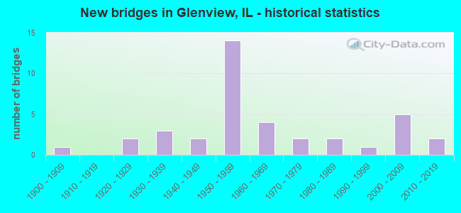
- New bridges - historical statistics
- 11900-1909
- 21920-1929
- 31930-1939
- 21940-1949
- 141950-1959
- 41960-1969
- 21970-1979
- 21980-1989
- 11990-1999
- 52000-2009
- 22010-2019

- Reconstructed bridges - Historical Statistics
- 21970-1979
- 11980-1989
- 11990-1999
- 32000-2009
- 12010-2019


- Bridge Condition - Deck
- 4.5%Excellent
- 4.5%Very good
- 31.8%Good
- 40.9%Satisfactory
- 4.5%Fair
- 4.5%Poor
- 9.1%Critical

- Bridge Condition - Superstructure
- 27.3%Very good
- 27.3%Good
- 22.7%Satisfactory
- 9.1%Fair
- 4.5%Poor
- 9.1%Critical

- Bridge Condition - Substructure
- 13.6%Very good
- 31.8%Good
- 45.5%Satisfactory
- 9.1%Fair

- Bridge Condition - Channel
- 11.1%Excellent
- 22.2%Very good
- 44.4%Good
- 22.2%Satisfactory
Find on map >> Show street view
Structure Number: 160243, Location: 0.7 SE I-294 (Lat: 42.074356, Lng: -87.857394), Route carried "on" structure: State highway 21, Year Built: 1970, Year Reconstructed: 2008, Status: Open, Structure Length: 5.07m (16.63ft), Average Daily Traffic: 8,050 (year 2021), Truck Traffic: 3%, Average Future Daily Traffic: 29,973 (year 2032), Design Load: HS 20, Features Intersected: RR - UP
Minimum Vertical Clearance: 30+ m (98+ ft), Kilometerpoint: 7.644, Lanes on structure: 4, Base Highway Network: Yes, Owner: State Highway Agency, Approaching Roadway Width: 14.6m (47.9ft), Skew: 30 degrees, Material/Design: Prestressed concrete, Design/Construction: Box Beam or Girders - Multiple, Number Of Spans In Main Unit: 3, Length of Maximum Span: 16.6m (54.5ft), Curb or Sidewalk Widths: Left: 1.5m (4.9ft), Right: 1.5m (4.9ft), Curb-To-Curb Width: 17.1m (56.1ft), Out-to-Out Width: 25.0m (82.0ft)
Condition: Deck: Good, Superstructure: Good, Substructure: Satisfactory, Operating Rating: 89.1 metric tons, Method Used To Determine Operating Rating: Load Factor (LF) rating reported by rating factor (RF) method using MS18 loading, Inventory Rating: 64.5 metric tons, Method Used To Determine Inventory Rating: Load Factor (LF) rating reported by rating factor (RF) method using MS18 loading, Structural Evaluation: Equal to present minimum criteria, Deck Geometry: Somewhat better than minimum adequacy, Underclear: Equal to present minimum criteria, Approach Roadway Alignment: Equal to present minimum criteria, Length Of Structure Improvement: 4.69m (15.39ft), Designated Inspection Frequency: Every 24 months, Inspection Date: October 2021, Bridge Improvement Cost: $833,000, Roadway Improvement Cost: $83,000, Total Project Cost: $1,250,000, Deck Structure Type: Concrete Cast-file-Place, Wearing Surface/Protective System: Wearing Surface: Integral Concrete, Deck Protection: Epoxy Coated Reinforcing
Find on map >> Show street view
Structure Number: 160307, Location: 0.1 M S GLENVIEW RD (Lat: 42.072072, Lng: -87.799319), Route carried "on" structure: State highway 43, Year Built: 1927, Year Reconstructed: 1985, Status: Open, Structure Length: 1.45m (4.76ft), Average Daily Traffic: 19,800 (year 2021), Truck Traffic: 2%, Average Future Daily Traffic: 25,750 (year 2032), Design Load: HS 20, Features Intersected: W FK N BR CHI RIV
Minimum Vertical Clearance: 30+ m (98+ ft), Kilometerpoint: 63.712, Lanes on structure: 4, Base Highway Network: Yes, Owner: State Highway Agency, Approaching Roadway Width: 20.7m (67.9ft), Material/Design: Concrete, Design/Construction: Slab, Number Of Spans In Main Unit: 2, Length of Maximum Span: 7.0m (23.0ft), Curb or Sidewalk Widths: Left: 1.5m (4.9ft), Right: 1.5m (4.9ft), Curb-To-Curb Width: 20.5m (67.3ft), Out-to-Out Width: 24.3m (79.7ft)
Condition: Deck: Satisfactory, Superstructure: Satisfactory, Substructure: Fair, Channel: Good, Operating Rating: 58.3 metric tons, Method Used To Determine Operating Rating: Load Factor (LF) rating reported by rating factor (RF) method using MS18 loading, Inventory Rating: 34.7 metric tons, Method Used To Determine Inventory Rating: Load Factor (LF) rating reported by rating factor (RF) method using MS18 loading, Structural Evaluation: Somewhat better than minimum adequacy, Deck Geometry: Superior to present desirable criteria, Waterway Adequacy: Equal to present desirable criteria, Approach Roadway Alignment: Equal to present desirable criteria, Length Of Structure Improvement: 1.46m (4.79ft), Designated Inspection Frequency: Every 24 months, Other Special Inspection Frequency: Every 48 months, Inspection Date: November 2021, Other Special Inspection Date: November 2021, Bridge Improvement Cost: $274,000, Roadway Improvement Cost: $27,000, Total Project Cost: $411,000, Deck Structure Type: Concrete Cast-file-Place, Wearing Surface/Protective System: Deck Protection: Epoxy Coated Reinforcing
Find on map >> Show street view
Structure Number: 160531, Location: 2.4 M S IL 68 (Lat: 42.106522, Lng: -87.868169), Route carried "on" structure: Other road , Year Built: 1958, Year Reconstructed: 2008, Status: Open, Structure Length: 7.17m (23.52ft), Average Daily Traffic: 46,700 (year 2018), Truck Traffic: 10%, Average Future Daily Traffic: 45,011 (year 2032), Design Load: HS 20, Features Intersected: I-294 TRI STATE TOLL, Facility Carried by Structure: WILLOW RD
Minimum Vertical Clearance: 30+ m (98+ ft), Kilometerpoint: 23.769, Lanes on structure: 10, Lanes under structure: 8, Base Highway Network: Yes, Owner: State Highway Agency, Approaching Roadway Width: 40.2m (131.9ft), Skew: 32 degrees, Material/Design: Prestressed concrete continuous, Design/Construction: Stringer/Multi-beam, Number Of Spans In Main Unit: 2, Length of Maximum Span: 21.9m (71.9ft), Curb or Sidewalk Widths: Left: 2.0m (6.6ft), Right: 2.0m (6.6ft), Curb-To-Curb Width: 40.2m (131.9ft), Out-to-Out Width: 47.2m (154.9ft)
Condition: Deck: Good, Superstructure: Good, Substructure: Satisfactory, Operating Rating: 66.7 metric tons, Method Used To Determine Operating Rating: Load Factor (LF) rating reported by rating factor (RF) method using MS18 loading, Inventory Rating: 39.9 metric tons, Method Used To Determine Inventory Rating: Load Factor (LF) rating reported by rating factor (RF) method using MS18 loading, Structural Evaluation: Equal to present minimum criteria, Deck Geometry: Somewhat better than minimum adequacy, Underclear: High priority of corrective action, Approach Roadway Alignment: Equal to present desirable criteria, Designated Inspection Frequency: Every 24 months, Inspection Date: May 2019, Deck Structure Type: Concrete Cast-file-Place, Wearing Surface/Protective System: Deck Protection: Epoxy Coated Reinforcing
Find on map >> Show street view
Structure Number: 160533, Location: 1 M W IL 43 (Lat: 42.105489, Lng: -87.819681), Route carried "on" structure: Other road , Year Built: 1942, Year Reconstructed: 2019, Status: Open, Structure Length: 8.87m (29.10ft), Average Daily Traffic: 35,600 (year 2021), Truck Traffic: 7%, Average Future Daily Traffic: 38,831 (year 2032), Features Intersected: RR - METRA, Facility Carried by Structure: WILLOW RD
Minimum Vertical Clearance: 30+ m (98+ ft), Kilometerpoint: 27.825, Lanes on structure: 4, Lanes under structure: 2, Base Highway Network: Yes, Owner: State Highway Agency, Approaching Roadway Width: 20.7m (67.9ft), Skew: 21 degrees, Material/Design: Steel continuous, Design/Construction: Stringer/Multi-beam, Number Of Spans In Main Unit: 3, Length of Maximum Span: 34.0m (111.5ft), Curb or Sidewalk Widths: Left: 1.5m (4.9ft), Right: 1.5m (4.9ft), Curb-To-Curb Width: 18.9m (62.0ft), Out-to-Out Width: 24.4m (80.1ft)
Condition: Deck: Excellent, Superstructure: Fair, Substructure: Very good, Operating Rating: 94.3 metric tons, Method Used To Determine Operating Rating: Load Factor (LF) rating reported by rating factor (RF) method using MS18 loading, Inventory Rating: 45.4 metric tons, Method Used To Determine Inventory Rating: Load Factor (LF) rating reported by rating factor (RF) method using MS18 loading, Structural Evaluation: Somewhat better than minimum adequacy, Deck Geometry: Equal to present minimum criteria, Underclear: High priority of corrective action, Approach Roadway Alignment: Equal to present desirable criteria, Length Of Structure Improvement: 5.79m (19.00ft), Designated Inspection Frequency: Every 24 months, Inspection Date: December 2020, Bridge Improvement Cost: $866,000, Roadway Improvement Cost: $87,000, Total Project Cost: $1,299,000, Deck Structure Type: Concrete Cast-file-Place, Wearing Surface/Protective System: Deck Protection: Epoxy Coated Reinforcing
Find on map >> Show street view
Structure Number: 160544, Location: 1.1 M E ILL 43 P14 (Lat: 42.079803, Lng: -87.778069), Route carried "on" structure: Other road , Year Built: 1935, Year Reconstructed: 1981, Status: Temporarily open, Structure Length: 2.56m (8.40ft), Average Daily Traffic: 23,000 (year 2018), Truck Traffic: 3%, Average Future Daily Traffic: 32,754 (year 2032), Design Load: HS 20, Features Intersected: N Br Chicago River, Facility Carried by Structure: FAU-1292 (E Lake A
Minimum Vertical Clearance: 30+ m (98+ ft), Kilometerpoint: 24.300, Lanes on structure: 4, Base Highway Network: Yes, Owner: County Highway Agency, Approaching Roadway Width: 13.4m (44.0ft), Material/Design: Prestressed concrete, Design/Construction: Box Beam or Girders - Multiple, Number Of Spans In Main Unit: 3, Length of Maximum Span: 8.2m (26.9ft), Curb or Sidewalk Widths: Left: 1.5m (4.9ft), Right: 1.5m (4.9ft), Curb-To-Curb Width: 13.9m (45.6ft), Out-to-Out Width: 17.5m (57.4ft)
Condition: Deck: Critical, Superstructure: Critical, Substructure: Fair, Channel: Very good, Structural Evaluation: High priority of replacement, Deck Geometry: High priority of replacement, Waterway Adequacy: Equal to present desirable criteria, Approach Roadway Alignment: Equal to present desirable criteria, Length Of Structure Improvement: 3.44m (11.29ft), Designated Inspection Frequency: Every 24 months, Underwater Inspection Frequency: Every 60 months, Other Special Inspection Frequency: Every 12 months, Inspection Date: January 2021, Underwater Inspection Date: August 2020, Other Special Inspection Date: January 2022, Bridge Improvement Cost: $440,000, Roadway Improvement Cost: $44,000, Total Project Cost: $660,000, Deck Structure Type: Concrete Precast Panels, Wearing Surface/Protective System: Wearing Surface: Latex Concrete
Find on map >> Show street view
Structure Number: 160551, Location: .5 M W I-294 (Lat: 42.066000, Lng: -87.887753), Route carried "on" structure: Other road , Year Built: 1929, Year Reconstructed: 1979, Status: Open, Structure Length: 4.88m (16.01ft), Average Daily Traffic: 11,700 (year 2021), Truck Traffic: 3%, Average Future Daily Traffic: 16,274 (year 2032), Design Load: HS 20, Features Intersected: DES PLAINES RIVER, Facility Carried by Structure: CENTRAL RD
Minimum Vertical Clearance: 30+ m (98+ ft), Kilometerpoint: 11.587, Lanes on structure: 2, Base Highway Network: Yes, Owner: State Highway Agency, Approaching Roadway Width: 8.5m (27.9ft), Material/Design: Prestressed concrete, Design/Construction: Stringer/Multi-beam, Number Of Spans In Main Unit: 3, Length of Maximum Span: 16.2m (53.1ft), Curb or Sidewalk Widths: Left: 1.5m (4.9ft), Right: 1.5m (4.9ft), Curb-To-Curb Width: 13.4m (44.0ft), Out-to-Out Width: 17.1m (56.1ft)
Condition: Deck: Satisfactory, Superstructure: Satisfactory, Substructure: Good, Channel: Satisfactory, Operating Rating: 63.8 metric tons, Method Used To Determine Operating Rating: Load Factor (LF) rating reported by rating factor (RF) method using MS18 loading, Inventory Rating: 38.2 metric tons, Method Used To Determine Inventory Rating: Load Factor (LF) rating reported by rating factor (RF) method using MS18 loading, Structural Evaluation: Equal to present minimum criteria, Deck Geometry: Equal to present minimum criteria, Waterway Adequacy: Equal to present desirable criteria, Approach Roadway Alignment: Better than present minimum criteria, Length Of Structure Improvement: 4.88m (16.01ft), Designated Inspection Frequency: Every 24 months, Inspection Date: Febuary 2022, Bridge Improvement Cost: $645,000, Roadway Improvement Cost: $65,000, Total Project Cost: $968,000, Deck Structure Type: Concrete Cast-file-Place, Wearing Surface/Protective System: Deck Protection: Epoxy Coated Reinforcing
Find on map >> Show street view
Structure Number: 16082, Location: 1.3 M E ILL43 P14 (Lat: 42.068881, Lng: -87.774686), Route carried "on" structure: Other road , Year Built: 1932, Year Reconstructed: 1990, Status: Open, Structure Length: 2.02m (6.63ft), Average Daily Traffic: 11,300 (year 2018), Truck Traffic: 3%, Average Future Daily Traffic: 9,682 (year 2032), Design Load: HS 20, Features Intersected: M F N BR CHI RIV, Facility Carried by Structure: GLENVIEW RD
Minimum Vertical Clearance: 30+ m (98+ ft), Kilometerpoint: 7.789, Lanes on structure: 2, Base Highway Network: Yes, Owner: City or Municipal Highway Agency, Approaching Roadway Width: 10.4m (34.1ft), Skew: 1 degrees, Material/Design: Steel continuous, Design/Construction: Stringer/Multi-beam, Number Of Spans In Main Unit: 2, Length of Maximum Span: 10.1m (33.1ft), Curb or Sidewalk Widths: Left: 3.0m (9.8ft), Right: 1.5m (4.9ft), Curb-To-Curb Width: 9.1m (29.9ft), Out-to-Out Width: 15.1m (49.5ft)
Condition: Deck: Satisfactory, Superstructure: Fair, Substructure: Good, Channel: Good, Operating Rating: 75.8 metric tons, Method Used To Determine Operating Rating: Allowable Stress (AS) rating reported by rating factor (RF) method using MS18 loading, Inventory Rating: 45.0 metric tons, Method Used To Determine Inventory Rating: Allowable Stress (AS) rating reported by rating factor (RF) method using MS18 loading, Structural Evaluation: Somewhat better than minimum adequacy, Deck Geometry: High priority of corrective action, Waterway Adequacy: Equal to present desirable criteria, Approach Roadway Alignment: Equal to present desirable criteria, Length Of Structure Improvement: 2.83m (9.28ft), Designated Inspection Frequency: Every 24 months, Inspection Date: September 2021, Bridge Improvement Cost: $345,000, Roadway Improvement Cost: $35,000, Total Project Cost: $518,000, Deck Structure Type: Other, Wearing Surface/Protective System: Deck Protection: Epoxy Coated Reinforcing
Find on map >> Show street view
Structure Number: 161128, Location: 0.2 M W ILL 43 P14 (Lat: 42.080033, Lng: -87.801878), Route carried "on" structure: Other road , Year Built: 1961, Status: Posted for load, Structure Length: 1.71m (5.61ft), Average Daily Traffic: 24,300 (year 2018), Truck Traffic: 3%, Average Future Daily Traffic: 32,960 (year 2032), Design Load: HS 20, Features Intersected: W F N BR CHI RIV, Facility Carried by Structure: EAST LAKE AVE EXT
Minimum Vertical Clearance: 30+ m (98+ ft), Kilometerpoint: 22.273, Lanes on structure: 4, Base Highway Network: Yes, Owner: County Highway Agency, Approaching Roadway Width: 17.1m (56.1ft), Skew: 20 degrees, Material/Design: Prestressed concrete, Design/Construction: Box Beam or Girders - Multiple, Number Of Spans In Main Unit: 1, Number Of Approach Spans: 2, Length of Maximum Span: 15.2m (49.9ft), Curb or Sidewalk Widths: Left: 1.5m (4.9ft), Right: 1.5m (4.9ft), Curb-To-Curb Width: 17.1m (56.1ft), Out-to-Out Width: 20.7m (67.9ft)
Condition: Deck: Poor, Superstructure: Poor, Substructure: Satisfactory, Channel: Satisfactory, Operating Rating: 32.1 metric tons, Method Used To Determine Operating Rating: Load Factor (LF) rating reported by rating factor (RF) method using MS18 loading, Inventory Rating: 19.1 metric tons, Method Used To Determine Inventory Rating: Load Factor (LF) rating reported by rating factor (RF) method using MS18 loading, Structural Evaluation: Meets minimum limits, Deck Geometry: Somewhat better than minimum adequacy, Waterway Adequacy: Equal to present desirable criteria, Approach Roadway Alignment: Equal to present desirable criteria, Bridge Posting: Required (Relationship of Operating Rating to Maximum Legal Load: > 39.9% below), Designated Inspection Frequency: Every 24 months, Other Special Inspection Frequency: Every 12 months, Inspection Date: October 2020, Other Special Inspection Date: October 2021, Deck Structure Type: Concrete Precast Panels, Wearing Surface/Protective System: Wearing Surface: Latex Concrete, Deck Protection: Epoxy Coated Reinforcing
Find on map >> Show street view
Structure Number: 161129, Location: 0.5 M W ILL 43 P14 (Lat: 42.080289, Lng: -87.808953), Route carried "on" structure: Other road , Year Built: 1961, Status: Open, Structure Length: 5.42m (17.78ft), Average Daily Traffic: 5,000 (year 2018), Truck Traffic: 5%, Average Future Daily Traffic: 10,000 (year 2032), Design Load: HS 20, Features Intersected: EAST LAKE AVE EXT, Facility Carried by Structure: LEHIGH AVE
Minimum Vertical Clearance: 30+ m (98+ ft), Kilometerpoint: 3.589, Lanes on structure: 2, Lanes under structure: 4, Owner: County Highway Agency, Approaching Roadway Width: 7.3m (24.0ft), Skew: 2 degrees, Material/Design: Prestressed concrete, Design/Construction: Box Beam or Girders - Multiple, Number Of Spans In Main Unit: 1, Number Of Approach Spans: 4, Length of Maximum Span: 22.8m (74.8ft), Curb or Sidewalk Widths: Left: 1.5m (4.9ft), Right: 1.5m (4.9ft), Curb-To-Curb Width: 15.8m (51.8ft), Out-to-Out Width: 19.6m (64.3ft)
Condition: Deck: Critical, Superstructure: Critical, Substructure: Satisfactory, Operating Rating: 46.3 metric tons, Method Used To Determine Operating Rating: Load Factor (LF) rating reported by rating factor (RF) method using MS18 loading, Inventory Rating: 27.5 metric tons, Method Used To Determine Inventory Rating: Load Factor (LF) rating reported by rating factor (RF) method using MS18 loading, Structural Evaluation: High priority of replacement, Deck Geometry: Superior to present desirable criteria, Underclear: Meets minimum limits, Approach Roadway Alignment: Equal to present desirable criteria, Designated Inspection Frequency: Every 24 months, Other Special Inspection Frequency: Every 12 months, Inspection Date: April 2021, Other Special Inspection Date: July 2021, Deck Structure Type: Concrete Precast Panels, Wearing Surface/Protective System: Wearing Surface: Latex Concrete
Find on map >> Show street view
Structure Number: 16201, Location: .3 M S. OF W LAKE AV (Lat: 42.082856, Lng: -87.866192), Route carried "on" structure: Interstate 294, Year Built: 2009, Status: Open, Structure Length: 5.85m (19.19ft), Average Daily Traffic: 52,500 (year 2020), Truck Traffic: 14%, Average Future Daily Traffic: 57,165 (year 2032), Design Load: HS 20, Features Intersected: MILWAUKEE AVE ILL 21
Minimum Vertical Clearance: 30+ m (98+ ft), Kilometerpoint: 9.189, Lanes on structure: 3, Lanes under structure: 3, Base Highway Network: Yes, Toll: On toll road, Owner: State Toll Authority, Approaching Roadway Width: 22.4m (73.5ft), Skew: 5 degrees, Material/Design: Prestressed concrete, Design/Construction: Stringer/Multi-beam, Number Of Spans In Main Unit: 2, Length of Maximum Span: 27.6m (90.6ft), Curb-To-Curb Width: 22.4m (73.5ft), Out-to-Out Width: 23.3m (76.4ft)
Condition: Deck: Good, Superstructure: Very good, Substructure: Good, Operating Rating: 64.2 metric tons, Method Used To Determine Operating Rating: Load Factor (LF) rating reported by rating factor (RF) method using MS18 loading, Inventory Rating: 38.6 metric tons, Method Used To Determine Inventory Rating: Load Factor (LF) rating reported by rating factor (RF) method using MS18 loading, Structural Evaluation: Better than present minimum criteria, Deck Geometry: Superior to present desirable criteria, Underclear: High priority of corrective action, Approach Roadway Alignment: Equal to present desirable criteria, Designated Inspection Frequency: Every 24 months, Inspection Date: May 2019, Deck Structure Type: Concrete Cast-file-Place, Wearing Surface/Protective System: Deck Protection: Epoxy Coated Reinforcing
Find on map >> Show street view
Structure Number: 162011, Location: .3 M S. OF W LAKE AV (Lat: 42.082711, Lng: -87.866186), Route carried "on" structure: Interstate 294, Year Built: 2009, Status: Open, Structure Length: 5.85m (19.19ft), Average Daily Traffic: 52,500 (year 2020), Truck Traffic: 14%, Average Future Daily Traffic: 57,165 (year 2032), Design Load: HS 20, Features Intersected: MILWAUKEE AVE ILL 21
Minimum Vertical Clearance: 30+ m (98+ ft), Kilometerpoint: 9.205, Lanes on structure: 3, Lanes under structure: 3, Base Highway Network: Yes, Toll: On toll road, Owner: State Toll Authority, Approaching Roadway Width: 22.4m (73.5ft), Skew: 5 degrees, Material/Design: Prestressed concrete, Design/Construction: Stringer/Multi-beam, Number Of Spans In Main Unit: 2, Length of Maximum Span: 27.6m (90.6ft), Curb-To-Curb Width: 22.4m (73.5ft), Out-to-Out Width: 23.3m (76.4ft)
Condition: Deck: Satisfactory, Superstructure: Good, Substructure: Good, Operating Rating: 63.2 metric tons, Method Used To Determine Operating Rating: Load Factor (LF) rating reported by rating factor (RF) method using MS18 loading, Inventory Rating: 37.9 metric tons, Method Used To Determine Inventory Rating: Load Factor (LF) rating reported by rating factor (RF) method using MS18 loading, Structural Evaluation: Better than present minimum criteria, Deck Geometry: Superior to present desirable criteria, Underclear: High priority of corrective action, Approach Roadway Alignment: Equal to present desirable criteria, Designated Inspection Frequency: Every 24 months, Inspection Date: May 2019, Deck Structure Type: Concrete Cast-file-Place, Wearing Surface/Protective System: Deck Protection: Epoxy Coated Reinforcing
Find on map >> Show street view
Structure Number: 163227, Location: .54M N OF WILLOW RD (Lat: 42.117317, Lng: -87.877919), Route carried "on" structure: Other road , Year Built: 1988, Status: Open, Structure Length: 8.88m (29.13ft), Average Daily Traffic: 8,350 (year 2018), Truck Traffic: 3%, Average Future Daily Traffic: 7,468 (year 2032), Design Load: HS 20, Features Intersected: I-294(TRI-STATE), Facility Carried by Structure: SANDERS RD SB
Minimum Vertical Clearance: 30+ m (98+ ft), Kilometerpoint: 3.975, Lanes on structure: 2, Lanes under structure: 6, Base Highway Network: Yes, Toll: On toll road, Owner: County Highway Agency, Approaching Roadway Width: 15.8m (51.8ft), Skew: 33 degrees, Material/Design: Concrete continuous, Design/Construction: Stringer/Multi-beam, Number Of Spans In Main Unit: 4, Number Of Approach Spans: 2, Length of Maximum Span: 26.6m (87.3ft), Curb or Sidewalk Widths: Left: 1.5m (4.9ft), Right: 1.5m (4.9ft), Curb-To-Curb Width: 15.8m (51.8ft), Out-to-Out Width: 24.4m (80.1ft)
Condition: Deck: Satisfactory, Superstructure: Good, Substructure: Good, Operating Rating: 65.1 metric tons, Method Used To Determine Operating Rating: Load Factor (LF) rating reported by rating factor (RF) method using MS18 loading, Inventory Rating: 39.2 metric tons, Method Used To Determine Inventory Rating: Load Factor (LF) rating reported by rating factor (RF) method using MS18 loading, Structural Evaluation: Better than present minimum criteria, Deck Geometry: Superior to present desirable criteria, Underclear: Equal to present minimum criteria, Approach Roadway Alignment: Equal to present desirable criteria, Designated Inspection Frequency: Every 24 months, Inspection Date: May 2019, Deck Structure Type: Concrete Cast-file-Place, Wearing Surface/Protective System: Membrane: Built-up, Deck Protection: Epoxy Coated Reinforcing
Find on map >> Show street view
Structure Number: 166221, Location: 0.5 M NE LAKE P14 (Lat: 42.087300, Lng: -87.802744), Route carried "on" structure: Other road , Year Built: 2016, Status: Open, Structure Length: 1.99m (6.53ft), Average Daily Traffic: 11,400 (year 2018), Truck Traffic: 4%, Average Future Daily Traffic: 30,400 (year 2042), Design Load: HS 25 or greater, Features Intersected: W F N BR CHICAGO RIV, Facility Carried by Structure: CHESTNUT AVENUE
Minimum Vertical Clearance: 30+ m (98+ ft), Kilometerpoint: 1.577, Lanes on structure: 2, Owner: City or Municipal Highway Agency, Approaching Roadway Width: 10.1m (33.1ft), Skew: 3 degrees, Material/Design: Prestressed concrete, Design/Construction: Box Beam or Girders - Multiple, Number Of Spans In Main Unit: 1, Length of Maximum Span: 18.6m (61.0ft), Curb or Sidewalk Widths: Left: 3.3m (10.8ft), Right: 2.3m (7.5ft), Curb-To-Curb Width: 11.3m (37.1ft), Out-to-Out Width: 17.4m (57.1ft)
Condition: Deck: Very good, Superstructure: Very good, Substructure: Very good, Channel: Good, Operating Rating: 42.1 metric tons, Method Used To Determine Operating Rating: Assigned ratings based on Load and Resistance Factor Design (LRFD) reported by rating factor (RF) using HL93 loadings, Inventory Rating: 32.4 metric tons, Method Used To Determine Inventory Rating: Assigned ratings based on Load and Resistance Factor Design (LRFD) reported by rating factor (RF) using HL93 loadings, Structural Evaluation: Equal to present desirable criteria, Deck Geometry: Meets minimum limits, Waterway Adequacy: Superior to present desirable criteria, Approach Roadway Alignment: Equal to present desirable criteria, Designated Inspection Frequency: Every 48 months, Inspection Date: September 2019, Deck Structure Type: Concrete Precast Panels, Wearing Surface/Protective System: Wearing Surface: Bituminous, Membrane: Built-up
Find on map >> Show street view
Structure Number: 167054, Location: 0.5 MI N E LAKE AVE (Lat: 42.085658, Lng: -87.806161), Route carried "on" structure: City street , Year Built: 2019, Status: Open, Structure Length: 0.72m (2.36ft), Average Daily Traffic: 1,000 (year 2021), Average Future Daily Traffic: 1,100 (year 2040), Design Load: HS 25 or greater, Features Intersected: SOUTH NAVY DITCH, Facility Carried by Structure: BLACKTHORN DRIVE
Minimum Vertical Clearance: 30+ m (98+ ft), Kilometerpoint: 0.225, Lanes on structure: 2, Owner: City or Municipal Highway Agency, Approaching Roadway Width: 7.0m (23.0ft), Material/Design: Concrete, Design/Construction: Culvert, Number Of Spans In Main Unit: 2, Length of Maximum Span: 0.0m, Curb or Sidewalk Widths: Left: 1.5m (4.9ft), Right: 1.5m (4.9ft)
Condition: Channel: Excellent, Culverts: Excellent, Waterway Adequacy: Superior to present desirable criteria, Approach Roadway Alignment: Equal to present desirable criteria, Designated Inspection Frequency: Every 24 months, Inspection Date: May 2019, Wearing Surface/Protective System: Wearing Surface: Bituminous, Membrane: Built-up
Find on map >> Show street view
Structure Number: 167055, Location: WEST OF IL-43 (Lat: 42.075219, Lng: -87.800597), Route carried "on" structure: City street , Year Built: 1993, Status: Open, Structure Length: 1.61m (5.28ft), Average Daily Traffic: 1,950 (year 2018), Truck Traffic: 6%, Average Future Daily Traffic: 8,764 (year 2032), Design Load: HS 20, Features Intersected: W FK N BR CHI RIV, Facility Carried by Structure: GROVE ST
Minimum Vertical Clearance: 30+ m (98+ ft), Kilometerpoint: 0.402, Lanes on structure: 2, Owner: City or Municipal Highway Agency, Approaching Roadway Width: 9.8m (32.2ft), Material/Design: Steel, Design/Construction: Stringer/Multi-beam, Number Of Spans In Main Unit: 1, Length of Maximum Span: 14.8m (48.6ft), Curb or Sidewalk Widths: Left: 1.7m (5.6ft), Right: 1.7m (5.6ft), Curb-To-Curb Width: 9.8m (32.2ft), Out-to-Out Width: 14.0m (45.9ft)
Condition: Deck: Good, Superstructure: Very good, Substructure: Very good, Channel: Very good, Operating Rating: 72.3 metric tons, Method Used To Determine Operating Rating: Load Factor (LF) rating reported by rating factor (RF) method using MS18 loading, Inventory Rating: 43.1 metric tons, Method Used To Determine Inventory Rating: Load Factor (LF) rating reported by rating factor (RF) method using MS18 loading, Structural Evaluation: Equal to present desirable criteria, Deck Geometry: Somewhat better than minimum adequacy, Waterway Adequacy: Superior to present desirable criteria, Approach Roadway Alignment: Equal to present desirable criteria, Designated Inspection Frequency: Every 48 months, Inspection Date: June 2019, Deck Structure Type: Concrete Cast-file-Place, Wearing Surface/Protective System: Deck Protection: Epoxy Coated Reinforcing
Find on map >> Show street view
Structure Number: 167056, Location: 0.1 MI W IL-43 P14 (Lat: 42.072789, Lng: -87.800797), Route carried "on" structure: Other road , Year Built: 2001, Status: Open, Structure Length: 1.44m (4.72ft), Average Daily Traffic: 10,800 (year 2021), Truck Traffic: 2%, Average Future Daily Traffic: 12,360 (year 2032), Design Load: HS 20, Features Intersected: W F N BR CHI RIV, Facility Carried by Structure: GLENVIEW RD
Minimum Vertical Clearance: 30+ m (98+ ft), Kilometerpoint: 5.520, Lanes on structure: 5, Base Highway Network: Yes, Owner: City or Municipal Highway Agency, Approaching Roadway Width: 13.6m (44.6ft), Material/Design: Prestressed concrete, Design/Construction: Stringer/Multi-beam, Number Of Spans In Main Unit: 1, Length of Maximum Span: 14.2m (46.6ft), Curb-To-Curb Width: 23.5m (77.1ft), Out-to-Out Width: 30.1m (98.8ft)
Condition: Deck: Good, Superstructure: Very good, Substructure: Good, Channel: Good, Operating Rating: 64.2 metric tons, Method Used To Determine Operating Rating: Load Factor (LF) rating reported by rating factor (RF) method using MS18 loading, Inventory Rating: 38.2 metric tons, Method Used To Determine Inventory Rating: Load Factor (LF) rating reported by rating factor (RF) method using MS18 loading, Structural Evaluation: Better than present minimum criteria, Deck Geometry: Better than present minimum criteria, Waterway Adequacy: Equal to present desirable criteria, Approach Roadway Alignment: Superior to present desirable criteria, Designated Inspection Frequency: Every 48 months, Inspection Date: June 2019, Deck Structure Type: Other, Wearing Surface/Protective System: Deck Protection: Epoxy Coated Reinforcing
Find on map >> Show street view
Structure Number: 169708, Location: 0.5 M N WILLOW P14 (Lat: 42.117061, Lng: -87.877881), Route carried "on" structure: Other road , Year Built: 1958, Year Reconstructed: 2009, Status: Open, Structure Length: 8.84m (29.00ft), Average Daily Traffic: 8,350 (year 2018), Truck Traffic: 3%, Average Future Daily Traffic: 7,468 (year 2032), Design Load: HS 20, Features Intersected: I-294 (TRI-ST TOLL), Facility Carried by Structure: SANDERS RD NB
Minimum Vertical Clearance: 30+ m (98+ ft), Kilometerpoint: 4.007, Lanes on structure: 2, Lanes under structure: 6, Base Highway Network: Yes, Owner: County Highway Agency, Approaching Roadway Width: 9.1m (29.9ft), Skew: 4 degrees, Material/Design: Prestressed concrete, Design/Construction: Stringer/Multi-beam, Number Of Spans In Main Unit: 4, Length of Maximum Span: 26.5m (86.9ft), Curb or Sidewalk Widths: Left: 1.5m (4.9ft), Right: 1.5m (4.9ft), Curb-To-Curb Width: 9.1m (29.9ft), Out-to-Out Width: 13.1m (43.0ft)
Condition: Deck: Satisfactory, Superstructure: Satisfactory, Substructure: Good, Operating Rating: 74.8 metric tons, Method Used To Determine Operating Rating: Load Factor (LF) rating reported by rating factor (RF) method using MS18 loading, Inventory Rating: 45.0 metric tons, Method Used To Determine Inventory Rating: Load Factor (LF) rating reported by rating factor (RF) method using MS18 loading, Structural Evaluation: Equal to present minimum criteria, Deck Geometry: Meets minimum limits, Underclear: Equal to present minimum criteria, Approach Roadway Alignment: Somewhat better than minimum adequacy, Length Of Structure Improvement: 8.84m (29.00ft), Designated Inspection Frequency: Every 24 months, Inspection Date: May 2019, Bridge Improvement Cost: $658,000, Roadway Improvement Cost: $66,000, Total Project Cost: $987,000, Deck Structure Type: Concrete Cast-file-Place
Find on map >> Show street view
Structure Number: 169745, Location: 0.4M N ILL 21 P14 (Lat: 42.087333, Lng: -87.867133), Route carried "on" structure: Interstate 294, Year Built: 1958, Status: Open, Structure Length: 4.57m (14.99ft), Average Daily Traffic: 52,500 (year 2020), Truck Traffic: 14%, Average Future Daily Traffic: 57,165 (year 2032), Features Intersected: LAKE AVE
Minimum Vertical Clearance: 30+ m (98+ ft), Kilometerpoint: 8.642, Lanes on structure: 2, Lanes under structure: 2, Base Highway Network: Yes, Toll: On toll road, Owner: State Toll Authority, Approaching Roadway Width: 12.2m (40.0ft), Material/Design: Prestressed concrete, Design/Construction: Stringer/Multi-beam, Number Of Spans In Main Unit: 4, Length of Maximum Span: 21.0m (68.9ft), Curb-To-Curb Width: 10.5m (34.4ft), Out-to-Out Width: 18.6m (61.0ft)
Condition: Deck: Satisfactory, Superstructure: Good, Substructure: Satisfactory, Operating Rating: 68.4 metric tons, Method Used To Determine Operating Rating: Load Factor (LF) rating reported by rating factor (RF) method using MS18 loading, Inventory Rating: 40.8 metric tons, Method Used To Determine Inventory Rating: Load Factor (LF) rating reported by rating factor (RF) method using MS18 loading, Structural Evaluation: Equal to present minimum criteria, Deck Geometry: Meets minimum limits, Underclear: Somewhat better than minimum adequacy, Approach Roadway Alignment: Equal to present desirable criteria, Designated Inspection Frequency: Every 24 months, Inspection Date: May 2019, Deck Structure Type: Concrete Cast-file-Place, Wearing Surface/Protective System: Wearing Surface: Bituminous
Find on map >> Show street view
Structure Number: 169746, Location: 0.4M N ILL 21 P14 (Lat: 42.087203, Lng: -87.867094), Route carried "on" structure: Interstate 294, Year Built: 1958, Status: Open, Structure Length: 4.57m (14.99ft), Average Daily Traffic: 52,500 (year 2020), Truck Traffic: 14%, Average Future Daily Traffic: 57,165 (year 2032), Features Intersected: LAKE AVE
Minimum Vertical Clearance: 30+ m (98+ ft), Kilometerpoint: 8.658, Lanes on structure: 2, Lanes under structure: 2, Base Highway Network: Yes, Toll: On toll road, Owner: State Toll Authority, Approaching Roadway Width: 12.2m (40.0ft), Material/Design: Prestressed concrete, Design/Construction: Stringer/Multi-beam, Number Of Spans In Main Unit: 4, Length of Maximum Span: 21.0m (68.9ft), Curb-To-Curb Width: 10.5m (34.4ft), Out-to-Out Width: 18.6m (61.0ft)
Condition: Deck: Satisfactory, Superstructure: Good, Substructure: Satisfactory, Operating Rating: 63.8 metric tons, Method Used To Determine Operating Rating: Load Factor (LF) rating reported by rating factor (RF) method using MS18 loading, Inventory Rating: 38.2 metric tons, Method Used To Determine Inventory Rating: Load Factor (LF) rating reported by rating factor (RF) method using MS18 loading, Structural Evaluation: Equal to present minimum criteria, Deck Geometry: Meets minimum limits, Underclear: Somewhat better than minimum adequacy, Approach Roadway Alignment: Equal to present desirable criteria, Designated Inspection Frequency: Every 24 months, Inspection Date: May 2019, Deck Structure Type: Concrete Cast-file-Place, Wearing Surface/Protective System: Wearing Surface: Bituminous, Membrane: Built-up
Find on map >> Show street view
Structure Number: 169749, Location: 1 M N ILL 58 P14 (Lat: 42.066058, Lng: -87.867494), Route carried "on" structure: Interstate 294, Year Built: 1958, Status: Open, Structure Length: 5.61m (18.41ft), Average Daily Traffic: 52,500 (year 2020), Truck Traffic: 14%, Average Future Daily Traffic: 57,165 (year 2032), Features Intersected: CENTRAL RD
Minimum Vertical Clearance: 30+ m (98+ ft), Kilometerpoint: 11.040, Lanes on structure: 2, Lanes under structure: 2, Base Highway Network: Yes, Toll: On toll road, Owner: State Toll Authority, Approaching Roadway Width: 12.2m (40.0ft), Material/Design: Prestressed concrete, Design/Construction: Stringer/Multi-beam, Number Of Spans In Main Unit: 3, Length of Maximum Span: 20.7m (67.9ft), Curb-To-Curb Width: 10.5m (34.4ft), Out-to-Out Width: 18.6m (61.0ft)
Condition: Deck: Good, Superstructure: Very good, Substructure: Satisfactory, Operating Rating: 58.0 metric tons, Method Used To Determine Operating Rating: Load Factor (LF) rating reported by rating factor (RF) method using MS18 loading, Inventory Rating: 34.7 metric tons, Method Used To Determine Inventory Rating: Load Factor (LF) rating reported by rating factor (RF) method using MS18 loading, Structural Evaluation: Equal to present minimum criteria, Deck Geometry: Meets minimum limits, Underclear: Better than present minimum criteria, Approach Roadway Alignment: Equal to present desirable criteria, Designated Inspection Frequency: Every 24 months, Inspection Date: May 2019, Deck Structure Type: Concrete Cast-file-Place, Wearing Surface/Protective System: Wearing Surface: Bituminous, Membrane: Built-up
Find on map >> Show street view
Structure Number: 16975, Location: 1 M N ILL 58 P14 (Lat: 42.065914, Lng: -87.867506), Route carried "on" structure: Interstate 294, Year Built: 1958, Status: Open, Structure Length: 5.61m (18.41ft), Average Daily Traffic: 52,500 (year 2020), Truck Traffic: 14%, Average Future Daily Traffic: 57,165 (year 2032), Features Intersected: CENTRAL RD
Minimum Vertical Clearance: 30+ m (98+ ft), Kilometerpoint: 11.056, Lanes on structure: 2, Lanes under structure: 2, Base Highway Network: Yes, Toll: On toll road, Owner: State Toll Authority, Approaching Roadway Width: 12.2m (40.0ft), Material/Design: Prestressed concrete, Design/Construction: Stringer/Multi-beam, Number Of Spans In Main Unit: 3, Length of Maximum Span: 20.7m (67.9ft), Curb-To-Curb Width: 10.5m (34.4ft), Out-to-Out Width: 18.6m (61.0ft)
Condition: Deck: Good, Superstructure: Very good, Substructure: Satisfactory, Operating Rating: 58.0 metric tons, Method Used To Determine Operating Rating: Load Factor (LF) rating reported by rating factor (RF) method using MS18 loading, Inventory Rating: 34.7 metric tons, Method Used To Determine Inventory Rating: Load Factor (LF) rating reported by rating factor (RF) method using MS18 loading, Structural Evaluation: Equal to present minimum criteria, Deck Geometry: Meets minimum limits, Underclear: Better than present minimum criteria, Approach Roadway Alignment: Equal to present desirable criteria, Designated Inspection Frequency: Every 24 months, Inspection Date: May 2019, Deck Structure Type: Concrete Cast-file-Place, Wearing Surface/Protective System: Wearing Surface: Bituminous, Membrane: Built-up
Find on map >> Show street view
Structure Number: 169751, Location: 0.6 M N ILL 58 P11 (Lat: 42.063617, Lng: -87.867689), Route carried "on" structure: Interstate 294, Year Built: 1958, Status: Open, Structure Length: 8.60m (28.22ft), Average Daily Traffic: 52,500 (year 2020), Truck Traffic: 14%, Average Future Daily Traffic: 57,165 (year 2032), Features Intersected: C&NW RR
Minimum Vertical Clearance: 30+ m (98+ ft), Kilometerpoint: 11.313, Lanes on structure: 2, Base Highway Network: Yes, Toll: On toll road, Owner: State Toll Authority, Approaching Roadway Width: 12.2m (40.0ft), Skew: 5 degrees, Material/Design: Steel, Design/Construction: Stringer/Multi-beam, Number Of Spans In Main Unit: 3, Length of Maximum Span: 28.3m (92.8ft), Curb-To-Curb Width: 10.5m (34.4ft), Out-to-Out Width: 18.6m (61.0ft)
Condition: Deck: Satisfactory, Superstructure: Satisfactory, Substructure: Satisfactory, Operating Rating: 79.4 metric tons, Method Used To Determine Operating Rating: Load Factor (LF) rating reported by rating factor (RF) method using MS18 loading, Inventory Rating: 47.6 metric tons, Method Used To Determine Inventory Rating: Load Factor (LF) rating reported by rating factor (RF) method using MS18 loading, Structural Evaluation: Equal to present minimum criteria, Deck Geometry: Meets minimum limits, Underclear: High priority of corrective action, Approach Roadway Alignment: Equal to present desirable criteria, Designated Inspection Frequency: Every 24 months, Inspection Date: May 2019, Deck Structure Type: Concrete Cast-file-Place, Wearing Surface/Protective System: Wearing Surface: Bituminous, Membrane: Built-up
Find on map >> Show street view
Structure Number: 169752, Location: 0.6 M N ILL 58 P11 (Lat: 42.063472, Lng: -87.867700), Route carried "on" structure: Interstate 294, Year Built: 1958, Status: Open, Structure Length: 8.60m (28.22ft), Average Daily Traffic: 52,500 (year 2020), Truck Traffic: 14%, Average Future Daily Traffic: 57,165 (year 2032), Features Intersected: C&NW RR
Minimum Vertical Clearance: 30+ m (98+ ft), Kilometerpoint: 11.329, Lanes on structure: 2, Base Highway Network: Yes, Toll: On toll road, Owner: State Toll Authority, Approaching Roadway Width: 12.2m (40.0ft), Skew: 5 degrees, Material/Design: Steel, Design/Construction: Stringer/Multi-beam, Number Of Spans In Main Unit: 3, Length of Maximum Span: 28.3m (92.8ft), Curb-To-Curb Width: 10.5m (34.4ft), Out-to-Out Width: 18.6m (61.0ft)
Condition: Deck: Fair, Superstructure: Satisfactory, Substructure: Satisfactory, Operating Rating: 79.4 metric tons, Method Used To Determine Operating Rating: Load Factor (LF) rating reported by rating factor (RF) method using MS18 loading, Inventory Rating: 47.6 metric tons, Method Used To Determine Inventory Rating: Load Factor (LF) rating reported by rating factor (RF) method using MS18 loading, Structural Evaluation: Equal to present minimum criteria, Deck Geometry: Meets minimum limits, Underclear: High priority of corrective action, Approach Roadway Alignment: Equal to present desirable criteria, Designated Inspection Frequency: Every 24 months, Inspection Date: May 2019, Deck Structure Type: Concrete Cast-file-Place, Wearing Surface/Protective System: Wearing Surface: Bituminous, Membrane: Built-up
Find on map >> Show street view
Structure Number: 160308, Location: .75 M N GOLF RD P13 (Lat: 42.063194, Lng: -87.799731), Route carried "under" structure: State highway 43, Year Built: 1935, Structure Length: 0. m, Average Daily Traffic: 19,800 (year 2021), Truck Traffic: 2%, Features Intersected: ILL 43 (WAUKEGAN RD), Facility Carried by Structure: SOO (WICT) AMTK. R
Minimum Vertical Clearance: 4.65m (15.26ft), Kilometerpoint: 62.714, Lanes under structure: 4, Material/Design: Steel, Design/Construction: Girder and Floorbeam System, Length of Maximum Span: 41.5m (136.2ft)
Find on map >> Show street view
Structure Number: 160531, Location: 2.4 M S IL 68 (Lat: 42.106522, Lng: -87.868169), Route carried "under" structure: Interstate 294, Year Built: 1958, Structure Length: 0. m, Average Daily Traffic: 105,000 (year 2020), Truck Traffic: 14%, Features Intersected: I-294 TRI STATE TOLL, Facility Carried by Structure: WILLOW RD
Minimum Vertical Clearance: 4.65m (15.26ft), Kilometerpoint: 6.534, Lanes on structure: 10, Lanes under structure: 8, Material/Design: Prestressed concrete continuous, Design/Construction: Stringer/Multi-beam, Length of Maximum Span: 21.9m (71.9ft)
Find on map >> Show street view
Structure Number: 160533, Location: 1 M W IL 43 (Lat: 42.105486, Lng: -87.819233), Route carried "under" structure: Other road , Year Built: 1942, Structure Length: 0. m, Average Daily Traffic: 2,200 (year 2018), Truck Traffic: 3%, Features Intersected: RR - METRA, Facility Carried by Structure: WILLOW RD
Minimum Vertical Clearance: 6.55m (21.49ft), Kilometerpoint: 0.370, Lanes on structure: 4, Lanes under structure: 2, Material/Design: Steel continuous, Design/Construction: Stringer/Multi-beam, Length of Maximum Span: 34.0m (111.5ft)
Find on map >> Show street view
Structure Number: 160552, Location: 0.1 M E I294 P11,14 (Lat: 42.065889, Lng: -87.865061), Route carried "under" structure: Other road , Year Built: 1900, Structure Length: 0. m, Average Daily Traffic: 13,200 (year 2018), Truck Traffic: 2%, Features Intersected: CENTRAL RD, Facility Carried by Structure: C&NW RR
Minimum Vertical Clearance: 4.27m (14.01ft), Kilometerpoint: 13.470, Lanes under structure: 2, Material/Design: Steel, Length of Maximum Span: 11.3m (37.1ft)
Find on map >> Show street view
Structure Number: 161127, Location: 0.5 MI W ILL 43 (Lat: 42.080086, Lng: -87.808203), Route carried "under" structure: Other road , Year Built: 1961, Structure Length: 0. m, Average Daily Traffic: 24,300 (year 2018), Truck Traffic: 3%, Features Intersected: EAST LAKE AVENUE, Facility Carried by Structure: SOO (WICT) AMTRAK
Minimum Vertical Clearance: 4.50m (14.76ft), Kilometerpoint: 21.758, Lanes under structure: 4, Material/Design: Steel, Design/Construction: Stringer/Multi-beam, Length of Maximum Span: 24.5m (80.4ft)
Find on map >> Show street view
Structure Number: 161129, Location: 0.5 M W ILL 43 P14 (Lat: 42.080106, Lng: -87.809064), Route carried "under" structure: Other road , Year Built: 1961, Structure Length: 0. m, Average Daily Traffic: 23,800 (year 2018), Truck Traffic: 3%, Features Intersected: EAST LAKE AVE EXT, Facility Carried by Structure: LEHIGH AVE
Minimum Vertical Clearance: 4.85m (15.91ft), Kilometerpoint: 21.693, Lanes on structure: 2, Lanes under structure: 4, Material/Design: Prestressed concrete, Design/Construction: Box Beam or Girders - Multiple, Length of Maximum Span: 22.8m (74.8ft)
Find on map >> Show street view
Structure Number: 16201, Location: .3 M S. OF W LAKE AV (Lat: 42.082856, Lng: -87.866192), Route carried "under" structure: State highway 21, Year Built: 2009, Structure Length: 0. m, Average Daily Traffic: 8,050 (year 2021), Truck Traffic: 3%, Features Intersected: MILWAUKEE AVE ILL 21, Facility Carried by Structure: I-294 NB
Minimum Vertical Clearance: 4.72m (15.49ft), Kilometerpoint: 8.819, Lanes on structure: 3, Lanes under structure: 3, Toll: On toll road, Material/Design: Prestressed concrete, Design/Construction: Stringer/Multi-beam, Length of Maximum Span: 27.6m (90.6ft)
Find on map >> Show street view
Structure Number: 162011, Location: .3 M S. OF W LAKE AV (Lat: 42.083003, Lng: -87.866333), Route carried "under" structure: State highway 21, Year Built: 2009, Structure Length: 0. m, Average Daily Traffic: 8,050 (year 2021), Truck Traffic: 3%, Features Intersected: MILWAUKEE AVE ILL 21, Facility Carried by Structure: I-294 SB
Minimum Vertical Clearance: 4.72m (15.49ft), Kilometerpoint: 8.835, Lanes on structure: 3, Lanes under structure: 3, Toll: On toll road, Material/Design: Prestressed concrete, Design/Construction: Stringer/Multi-beam, Length of Maximum Span: 27.6m (90.6ft)
Find on map >> Show street view
Structure Number: 163206, Location: 0.2 MI E PFINGSTEN (Lat: 42.084114, Lng: -87.847350), Route carried "under" structure: Other road , Year Built: 1978, Structure Length: 0. m, Average Daily Traffic: 23,100 (year 2018), Truck Traffic: 3%, Features Intersected: EAST LAKE AVENUE, Facility Carried by Structure: C&NW RAILROAD
Minimum Vertical Clearance: 4.75m (15.58ft), Kilometerpoint: 18.072, Lanes under structure: 4, Material/Design: Steel, Design/Construction: Stringer/Multi-beam, Length of Maximum Span: 15.4m (50.5ft)
Find on map >> Show street view
Structure Number: 163227, Location: .54M N OF WILLOW RD (Lat: 42.116736, Lng: -87.877675), Route carried "under" structure: Interstate 294, Year Built: 1988, Structure Length: 0. m, Average Daily Traffic: 117,600 (year 2020), Truck Traffic: 14%, Features Intersected: I-294(TRI-STATE), Facility Carried by Structure: SANDERS RD SB
Minimum Vertical Clearance: 4.65m (15.26ft), Kilometerpoint: 5.101, Lanes on structure: 2, Lanes under structure: 6, Toll: On toll road, Material/Design: Concrete continuous, Design/Construction: Stringer/Multi-beam, Length of Maximum Span: 26.6m (87.3ft)
Find on map >> Show street view
Structure Number: 169708, Location: 0.5 M N WILLOW P14 (Lat: 42.116814, Lng: -87.877844), Route carried "under" structure: Interstate 294, Year Built: 1958, Structure Length: 0. m, Average Daily Traffic: 117,600 (year 2020), Truck Traffic: 14%, Features Intersected: I-294 (TRI-ST TOLL), Facility Carried by Structure: SANDERS RD NB
Minimum Vertical Clearance: 4.65m (15.26ft), Kilometerpoint: 5.085, Lanes on structure: 2, Lanes under structure: 6, Material/Design: Prestressed concrete, Design/Construction: Stringer/Multi-beam, Length of Maximum Span: 26.5m (86.9ft)
Find on map >> Show street view
Structure Number: 169745, Location: 0.4M N ILL 21 P14 (Lat: 42.087317, Lng: -87.867275), Route carried "under" structure: Other road , Year Built: 1958, Structure Length: 0. m, Average Daily Traffic: 20,100 (year 2018), Truck Traffic: 3%, Features Intersected: LAKE AVE, Facility Carried by Structure: I-294 SB
Minimum Vertical Clearance: 4.34m (14.24ft), Kilometerpoint: 16.254, Lanes on structure: 2, Lanes under structure: 2, Toll: On toll road, Material/Design: Prestressed concrete, Design/Construction: Stringer/Multi-beam, Length of Maximum Span: 21.0m (68.9ft)
Find on map >> Show street view
Structure Number: 169746, Location: 0.4M N ILL 21 P14 (Lat: 42.087353, Lng: -87.866878), Route carried "under" structure: Other road , Year Built: 1958, Structure Length: 0. m, Average Daily Traffic: 20,100 (year 2018), Truck Traffic: 3%, Features Intersected: LAKE AVE, Facility Carried by Structure: I-294 NB
Minimum Vertical Clearance: 4.34m (14.24ft), Kilometerpoint: 16.318, Lanes on structure: 2, Lanes under structure: 2, Toll: On toll road, Material/Design: Prestressed concrete, Design/Construction: Stringer/Multi-beam, Length of Maximum Span: 21.0m (68.9ft)
Find on map >> Show street view
Structure Number: 169749, Location: 1 M N ILL 58 P14 (Lat: 42.065906, Lng: -87.867256), Route carried "under" structure: Other road , Year Built: 1958, Structure Length: 0. m, Average Daily Traffic: 13,200 (year 2018), Truck Traffic: 2%, Features Intersected: CENTRAL RD, Facility Carried by Structure: I-294 NB
Minimum Vertical Clearance: 6.35m (20.83ft), Kilometerpoint: 13.277, Lanes on structure: 2, Lanes under structure: 2, Toll: On toll road, Material/Design: Prestressed concrete, Design/Construction: Stringer/Multi-beam, Length of Maximum Span: 20.7m (67.9ft)
Find on map >> Show street view
Structure Number: 16975, Location: 1 M N ILL 58 P14 (Lat: 42.065914, Lng: -87.867506), Route carried "under" structure: Other road , Year Built: 1958, Structure Length: 0. m, Average Daily Traffic: 13,200 (year 2018), Truck Traffic: 2%, Features Intersected: CENTRAL RD, Facility Carried by Structure: I-294 SB
Minimum Vertical Clearance: 6.58m (21.59ft), Kilometerpoint: 13.245, Lanes on structure: 2, Lanes under structure: 2, Toll: On toll road, Material/Design: Prestressed concrete, Design/Construction: Stringer/Multi-beam, Length of Maximum Span: 20.7m (67.9ft)