Bridge Statistics for Good Hope, Alabama (AL)
Condition, Traffic, Stress, Structural Evaluation, Project Costs
- National Bridge Inventory (NBI) Statistics
- 26Number of bridges
- 269ft / 82.2mTotal length
- $33,111,000Total costs
- 406,215Total average daily traffic
- 93,527Total average daily truck traffic
- National Bridge Inventory (NBI) Registered Bridges for Good Hope
- No street view available for this location
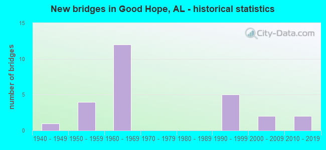
- New bridges - historical statistics
- 11940-1949
- 41950-1959
- 121960-1969
- 51990-1999
- 22000-2009
- 22010-2019

- Reconstructed bridges - Historical Statistics
- 11960-1969
- 01970-1979
- 01980-1989
- 01990-1999
- 12000-2009


- Bridge Condition - Deck
- 18.2%Very good
- 18.2%Good
- 54.5%Satisfactory
- 9.1%Fair

- Bridge Condition - Superstructure
- 9.1%Excellent
- 18.2%Very good
- 36.4%Good
- 27.3%Satisfactory
- 9.1%Fair

- Bridge Condition - Substructure
- 9.1%Excellent
- 18.2%Very good
- 27.3%Good
- 36.4%Satisfactory
- 9.1%Fair

- Bridge Condition - Channel
- 26.7%Very good
- 33.3%Good
- 26.7%Satisfactory
- 13.3%Fair

- Bridge Condition - Culverts
- 10.0%Excellent
- 20.0%Very good
- 20.0%Good
- 30.0%Satisfactory
- 20.0%Fair
Find on map >> Show street view
Structure Number: 5401, Location: CR 436 (Lat: 34.135250, Lng: -86.915586), Route carried "on" structure: County highway , Year Built: 1956, Status: Posted for load, Structure Length: 0.67m (2.20ft), Average Daily Traffic: 40 (year 1991), Average Future Daily Traffic: 100 (year 2036), Features Intersected: BRANCH, Facility Carried by Structure: CR 436
Minimum Vertical Clearance: 30+ m (98+ ft), Kilometerpoint: 0.010, Lanes on structure: 2, Owner: County Highway Agency, Approaching Roadway Width: 6.1m (20.0ft), Material/Design: Steel, Design/Construction: Stringer/Multi-beam, Number Of Spans In Main Unit: 1, Length of Maximum Span: 6.7m (22.0ft), Curb-To-Curb Width: 6.3m (20.7ft), Out-to-Out Width: 6.4m (21.0ft)
Condition: Deck: Fair, Superstructure: Fair, Substructure: Fair, Channel: Satisfactory, Operating Rating: 32.0 metric tons, Method Used To Determine Operating Rating: Load Factor (LF), Inventory Rating: 19.1 metric tons, Method Used To Determine Inventory Rating: Load Factor (LF), Structural Evaluation: Somewhat better than minimum adequacy, Deck Geometry: Somewhat better than minimum adequacy, Waterway Adequacy: Somewhat better than minimum adequacy, Approach Roadway Alignment: Somewhat better than minimum adequacy, Bridge Posting: Required (Relationship of Operating Rating to Maximum Legal Load: 30.0 - 39.9% below), Length Of Structure Improvement: 1.30m (4.27ft), Designated Inspection Frequency: Every 24 months, Other Special Inspection Frequency: Every 12 months, Inspection Date: November 2020, Other Special Inspection Date: November 2021, Bridge Improvement Cost: $187,000, Roadway Improvement Cost: $19,000, Total Project Cost: $206,000 ( Estimate for 2022), Deck Structure Type: Concrete Cast-file-Place
Find on map >> Show street view
Structure Number: 5551, Location: 1 MI S JCT I-65 (Lat: 34.102200, Lng: -86.874800), Route carried "on" structure: City street 37, Year Built: 1956, Status: Open, Structure Length: 1.06m (3.48ft), Average Daily Traffic: 2,000 (year 2021), Truck Traffic: 7%, Average Future Daily Traffic: 2,800 (year 2041), Design Load: H 15, Features Intersected: STREAM
Minimum Vertical Clearance: 30+ m (98+ ft), Kilometerpoint: 0.010, Lanes on structure: 2, Owner: City or Municipal Highway Agency, Approaching Roadway Width: 11.0m (36.1ft), Skew: 3 degrees, Material/Design: Concrete, Design/Construction: Culvert, Number Of Spans In Main Unit: 3, Length of Maximum Span: 3.2m (10.5ft)
Condition: Channel: Fair, Culverts: Fair, Operating Rating: 43.5 metric tons, Method Used To Determine Operating Rating: Field evaluation and documented engineering judgment, Inventory Rating: 32.7 metric tons, Method Used To Determine Inventory Rating: Field evaluation and documented engineering judgment, Structural Evaluation: Somewhat better than minimum adequacy, Waterway Adequacy: Equal to present minimum criteria, Approach Roadway Alignment: Equal to present minimum criteria, Length Of Structure Improvement: 1.73m (5.68ft), Designated Inspection Frequency: Every 24 months, Inspection Date: January 2021, Bridge Improvement Cost: $729,000, Roadway Improvement Cost: $73,000, Total Project Cost: $802,000 ( Estimate for 2022)
Find on map >> Show street view
Structure Number: 6478, Location: 3 MI S JCT US 278 (Lat: 34.133522, Lng: -86.867817), Route carried "on" structure: Interstate 65, Year Built: 1959, Status: Open, Structure Length: 0.98m (3.22ft), Average Daily Traffic: 39,960 (year 2020), Truck Traffic: 26%, Average Future Daily Traffic: 55,944 (year 2040), Design Load: HS 20, Features Intersected: BRANCH
Minimum Vertical Clearance: 30+ m (98+ ft), Kilometerpoint: 490.662, Lanes on structure: 4, Base Highway Network: Yes, Owner: State Highway Agency, Approaching Roadway Width: 14.6m (47.9ft), Skew: 10 degrees, Material/Design: Concrete, Design/Construction: Culvert, Number Of Spans In Main Unit: 3, Length of Maximum Span: 3.0m (9.8ft)
Condition: Channel: Very good, Culverts: Satisfactory, Operating Rating: 88.9 metric tons, Method Used To Determine Operating Rating: Load Factor (LF), Inventory Rating: 88.9 metric tons, Method Used To Determine Inventory Rating: Load Factor (LF), Structural Evaluation: Equal to present minimum criteria, Waterway Adequacy: Equal to present desirable criteria, Approach Roadway Alignment: Equal to present desirable criteria, Length Of Structure Improvement: 1.65m (5.41ft), Designated Inspection Frequency: Every 24 months, Inspection Date: January 2022, Bridge Improvement Cost: $1,986,000, Roadway Improvement Cost: $199,000, Total Project Cost: $2,185,000 ( Estimate for 2022)
Find on map >> Show street view
Structure Number: 6764, Location: Cr 222 (Lat: 34.094114, Lng: -86.945700), Route carried "on" structure: County highway 22, Year Built: 1949, Year Reconstructed: 1960, Status: Open, Structure Length: 3.08m (10.10ft), Average Daily Traffic: 2,200 (year 1991), Truck Traffic: 10%, Average Future Daily Traffic: 3,000 (year 2035), Design Load: H 15, Features Intersected: BRANCH
Minimum Vertical Clearance: 30+ m (98+ ft), Kilometerpoint: 0.010, Lanes on structure: 2, Owner: County Highway Agency, Approaching Roadway Width: 7.3m (24.0ft), Skew: 3 degrees, Material/Design: Concrete, Design/Construction: Culvert, Number Of Spans In Main Unit: 2, Length of Maximum Span: 3.7m (12.1ft)
Condition: Channel: Satisfactory, Culverts: Fair, Operating Rating: 67.0 metric tons, Method Used To Determine Operating Rating: Load Factor (LF), Inventory Rating: 40.2 metric tons, Method Used To Determine Inventory Rating: Load Factor (LF), Structural Evaluation: Somewhat better than minimum adequacy, Waterway Adequacy: Somewhat better than minimum adequacy, Approach Roadway Alignment: Better than present minimum criteria, Length Of Structure Improvement: 3.93m (12.89ft), Designated Inspection Frequency: Every 24 months, Inspection Date: October 2020, Bridge Improvement Cost: $1,270,000, Roadway Improvement Cost: $127,000, Total Project Cost: $1,397,000 ( Estimate for 2022), Wearing Surface/Protective System: Wearing Surface: Bituminous
Find on map >> Show street view
Structure Number: 6815, Location: 6 MI S JCT US 278 (Lat: 34.088333, Lng: -86.866667), Route carried "on" structure: Interstate 65, Year Built: 1960, Status: Open, Structure Length: 1.13m (3.71ft), Average Daily Traffic: 41,584 (year 2020), Truck Traffic: 26%, Average Future Daily Traffic: 58,218 (year 2040), Design Load: HS 20, Features Intersected: BAVERS CREEK
Minimum Vertical Clearance: 30+ m (98+ ft), Kilometerpoint: 485.723, Lanes on structure: 4, Base Highway Network: Yes, Owner: State Highway Agency, Approaching Roadway Width: 14.6m (47.9ft), Skew: 13 degrees, Material/Design: Concrete, Design/Construction: Culvert, Number Of Spans In Main Unit: 3, Length of Maximum Span: 3.0m (9.8ft)
Condition: Channel: Satisfactory, Culverts: Satisfactory, Operating Rating: 88.9 metric tons, Method Used To Determine Operating Rating: Load Factor (LF), Inventory Rating: 88.9 metric tons, Method Used To Determine Inventory Rating: Load Factor (LF), Structural Evaluation: Equal to present minimum criteria, Waterway Adequacy: Better than present minimum criteria, Approach Roadway Alignment: Equal to present desirable criteria, Length Of Structure Improvement: 1.81m (5.94ft), Designated Inspection Frequency: Every 24 months, Inspection Date: January 2022, Bridge Improvement Cost: $2,690,000, Roadway Improvement Cost: $269,000, Total Project Cost: $2,959,000 ( Estimate for 2022)
Find on map >> Show street view
Structure Number: 6816, Location: 5 MI S JCT US 278 * I65 (Lat: 34.095000, Lng: -86.866667), Route carried "on" structure: County highway 616, Year Built: 1960, Status: Open, Structure Length: 6.98m (22.90ft), Average Daily Traffic: 1,022 (year 2020), Truck Traffic: 3%, Average Future Daily Traffic: 1,431 (year 2040), Design Load: HS 20, Features Intersected: I65
Minimum Vertical Clearance: 30+ m (98+ ft), Kilometerpoint: 0.000, Lanes on structure: 2, Lanes under structure: 4, Owner: State Highway Agency, Approaching Roadway Width: 11.0m (36.1ft), Material/Design: Concrete continuous, Design/Construction: Tee Beam, Number Of Spans In Main Unit: 4, Length of Maximum Span: 19.2m (63.0ft), Curb or Sidewalk Widths: Left: 0.5m (1.6ft), Right: 0.5m (1.6ft), Curb-To-Curb Width: 8.5m (27.9ft), Out-to-Out Width: 10.0m (32.8ft)
Condition: Deck: Satisfactory, Superstructure: Good, Substructure: Good, Operating Rating: 50.6 metric tons, Method Used To Determine Operating Rating: Load Factor (LF), Inventory Rating: 30.6 metric tons, Method Used To Determine Inventory Rating: Load Factor (LF), Structural Evaluation: Better than present minimum criteria, Deck Geometry: Somewhat better than minimum adequacy, Underclear: Equal to present minimum criteria, Approach Roadway Alignment: Somewhat better than minimum adequacy, Length Of Structure Improvement: 8.01m (26.28ft), Designated Inspection Frequency: Every 24 months, Inspection Date: Febuary 2022, Bridge Improvement Cost: $1,758,000, Roadway Improvement Cost: $176,000, Total Project Cost: $1,934,000 ( Estimate for 2022), Deck Structure Type: Concrete Cast-file-Place
Find on map >> Show street view
Structure Number: 6817, Location: 3.7 MI S JCT US 278 (Lat: 34.115000, Lng: -86.866667), Route carried "on" structure: Interstate 65, Year Built: 1960, Status: Open, Structure Length: 0.73m (2.40ft), Average Daily Traffic: 39,960 (year 2020), Truck Traffic: 26%, Average Future Daily Traffic: 55,944 (year 2040), Design Load: HS 20, Features Intersected: BRANCH
Minimum Vertical Clearance: 30+ m (98+ ft), Kilometerpoint: 488.782, Lanes on structure: 4, Base Highway Network: Yes, Owner: State Highway Agency, Approaching Roadway Width: 14.6m (47.9ft), Skew: 14 degrees, Material/Design: Concrete, Design/Construction: Culvert, Number Of Spans In Main Unit: 2, Length of Maximum Span: 2.4m (7.9ft)
Condition: Channel: Fair, Culverts: Satisfactory, Operating Rating: 68.9 metric tons, Method Used To Determine Operating Rating: Load Factor (LF), Inventory Rating: 41.3 metric tons, Method Used To Determine Inventory Rating: Load Factor (LF), Structural Evaluation: Equal to present minimum criteria, Waterway Adequacy: Equal to present minimum criteria, Approach Roadway Alignment: Equal to present desirable criteria, Length Of Structure Improvement: 1.38m (4.53ft), Designated Inspection Frequency: Every 24 months, Inspection Date: January 2022, Bridge Improvement Cost: $1,343,000, Roadway Improvement Cost: $134,000, Total Project Cost: $1,477,000 ( Estimate for 2022)
Find on map >> Show street view
Structure Number: 6818, Location: 3 MI S JCT US 278 * I65 (Lat: 34.130206, Lng: -86.867161), Route carried "on" structure: County highway 222, Year Built: 1960, Year Reconstructed: 2008, Status: Open, Structure Length: 7.53m (24.70ft), Average Daily Traffic: 6,183 (year 2020), Truck Traffic: 6%, Average Future Daily Traffic: 8,544 (year 2040), Design Load: H 20, Features Intersected: I65
Minimum Vertical Clearance: 30+ m (98+ ft), Kilometerpoint: 0.000, Lanes on structure: 3, Lanes under structure: 4, Owner: State Highway Agency, Approaching Roadway Width: 9.8m (32.2ft), Material/Design: Concrete continuous, Design/Construction: Tee Beam, Number Of Spans In Main Unit: 4, Length of Maximum Span: 27.4m (89.9ft), Curb-To-Curb Width: 17.1m (56.1ft), Out-to-Out Width: 18.2m (59.7ft)
Condition: Deck: Satisfactory, Superstructure: Satisfactory, Substructure: Satisfactory, Operating Rating: 44.5 metric tons, Method Used To Determine Operating Rating: Load Factor (LF), Inventory Rating: 27.5 metric tons, Method Used To Determine Inventory Rating: Load Factor (LF), Structural Evaluation: Equal to present minimum criteria, Deck Geometry: Superior to present desirable criteria, Underclear: Equal to present minimum criteria, Approach Roadway Alignment: Better than present minimum criteria, Length Of Structure Improvement: 8.55m (28.05ft), Designated Inspection Frequency: Every 24 months, Inspection Date: December 2021, Bridge Improvement Cost: $3,459,000, Roadway Improvement Cost: $346,000, Total Project Cost: $3,805,000 ( Estimate for 2022), Deck Structure Type: Concrete Cast-file-Place
Find on map >> Show street view
Structure Number: 6819, Location: 2 MI S JCT US 278 * I65 (Lat: 34.148292, Lng: -86.869361), Route carried "on" structure: County highway 436, Year Built: 1960, Status: Open, Structure Length: 8.08m (26.51ft), Average Daily Traffic: 840 (year 2020), Truck Traffic: 1%, Average Future Daily Traffic: 1,176 (year 2040), Design Load: H 20, Features Intersected: I65
Minimum Vertical Clearance: 30+ m (98+ ft), Kilometerpoint: 0.000, Lanes on structure: 2, Lanes under structure: 4, Owner: State Highway Agency, Approaching Roadway Width: 9.8m (32.2ft), Skew: 1 degrees, Material/Design: Concrete continuous, Design/Construction: Tee Beam, Number Of Spans In Main Unit: 4, Length of Maximum Span: 22.3m (73.2ft), Curb or Sidewalk Widths: Left: 0.5m (1.6ft), Right: 0.5m (1.6ft), Curb-To-Curb Width: 7.3m (24.0ft), Out-to-Out Width: 8.8m (28.9ft)
Condition: Deck: Satisfactory, Superstructure: Good, Substructure: Good, Operating Rating: 41.6 metric tons, Method Used To Determine Operating Rating: Load Factor (LF), Inventory Rating: 25.1 metric tons, Method Used To Determine Inventory Rating: Load Factor (LF), Structural Evaluation: Equal to present minimum criteria, Deck Geometry: Meets minimum limits, Underclear: Equal to present minimum criteria, Approach Roadway Alignment: Equal to present minimum criteria, Length Of Structure Improvement: 9.08m (29.79ft), Designated Inspection Frequency: Every 24 months, Inspection Date: Febuary 2022, Bridge Improvement Cost: $1,744,000, Roadway Improvement Cost: $174,000, Total Project Cost: $1,918,000 ( Estimate for 2022), Deck Structure Type: Concrete Cast-file-Place, Wearing Surface/Protective System: Wearing Surface: Bituminous
Find on map >> Show street view
Structure Number: 6953, Location: CR 813 (Lat: 34.092311, Lng: -86.947864), Route carried "on" structure: County highway 13, Year Built: 1960, Status: Open, Structure Length: 11.25m (36.91ft), Average Daily Traffic: 500 (year 1991), Truck Traffic: 5%, Average Future Daily Traffic: 700 (year 2033), Design Load: H 15, Features Intersected: RYAN CREEK
Minimum Vertical Clearance: 30+ m (98+ ft), Kilometerpoint: 0.010, Lanes on structure: 2, Owner: County Highway Agency, Approaching Roadway Width: 9.1m (29.9ft), Material/Design: Steel continuous, Design/Construction: Stringer/Multi-beam, Number Of Spans In Main Unit: 4, Length of Maximum Span: 30.5m (100.1ft), Curb-To-Curb Width: 6.7m (22.0ft), Out-to-Out Width: 7.1m (23.3ft)
Condition: Deck: Satisfactory, Superstructure: Satisfactory, Substructure: Satisfactory, Channel: Good, Operating Rating: 38.6 metric tons, Method Used To Determine Operating Rating: Load Factor (LF), Inventory Rating: 23.0 metric tons, Method Used To Determine Inventory Rating: Load Factor (LF), Structural Evaluation: Equal to present minimum criteria, Deck Geometry: Meets minimum limits, Waterway Adequacy: Better than present minimum criteria, Approach Roadway Alignment: Better than present minimum criteria, Length Of Structure Improvement: 12.13m (39.80ft), Designated Inspection Frequency: Every 24 months, Inspection Date: March 2021, Bridge Improvement Cost: $1,913,000, Roadway Improvement Cost: $191,000, Total Project Cost: $2,104,000 ( Estimate for 2022), Deck Structure Type: Concrete Cast-file-Place
Find on map >> Show street view
Structure Number: 7085, Location: N JCT I-65 AND SR 69 (Lat: 34.113075, Lng: -86.866522), Route carried "on" structure: State highway 69, Year Built: 1960, Status: Open, Structure Length: 9.88m (32.41ft), Average Daily Traffic: 7,216 (year 2020), Truck Traffic: 3%, Average Future Daily Traffic: 10,102 (year 2040), Design Load: HS 20, Features Intersected: I-65
Minimum Vertical Clearance: 30+ m (98+ ft), Kilometerpoint: 385.111, Lanes on structure: 2, Lanes under structure: 4, Owner: State Highway Agency, Approaching Roadway Width: 10.4m (34.1ft), Skew: 4 degrees, Material/Design: Concrete continuous, Design/Construction: Tee Beam, Number Of Spans In Main Unit: 4, Length of Maximum Span: 27.1m (88.9ft), Curb or Sidewalk Widths: Left: 0.5m (1.6ft), Right: 0.5m (1.6ft), Curb-To-Curb Width: 8.5m (27.9ft), Out-to-Out Width: 10.1m (33.1ft)
Condition: Deck: Satisfactory, Superstructure: Satisfactory, Substructure: Satisfactory, Operating Rating: 52.4 metric tons, Method Used To Determine Operating Rating: Load Factor (LF), Inventory Rating: 32.0 metric tons, Method Used To Determine Inventory Rating: Load Factor (LF), Structural Evaluation: Equal to present minimum criteria, Deck Geometry: Meets minimum limits, Underclear: Somewhat better than minimum adequacy, Approach Roadway Alignment: Better than present minimum criteria, Length Of Structure Improvement: 10.81m (35.47ft), Designated Inspection Frequency: Every 24 months, Inspection Date: November 2021, Bridge Improvement Cost: $2,446,000, Roadway Improvement Cost: $245,000, Total Project Cost: $2,691,000 ( Estimate for 2022), Deck Structure Type: Concrete Cast-file-Place
Find on map >> Show street view
Structure Number: 7676, Location: CR 438 (Lat: 34.091292, Lng: -86.923622), Route carried "on" structure: County highway 18, Year Built: 1962, Status: Posted for load, Structure Length: 9.20m (30.18ft), Average Daily Traffic: 500 (year 1991), Truck Traffic: 10%, Average Future Daily Traffic: 750 (year 2035), Design Load: H 15, Features Intersected: RYAN CREEK, Facility Carried by Structure: CO. RT. 438
Minimum Vertical Clearance: 30+ m (98+ ft), Kilometerpoint: 0.010, Lanes on structure: 2, Owner: County Highway Agency, Approaching Roadway Width: 7.3m (24.0ft), Material/Design: Steel continuous, Design/Construction: Stringer/Multi-beam, Number Of Spans In Main Unit: 4, Number Of Approach Spans: 1, Length of Maximum Span: 30.5m (100.1ft), Curb-To-Curb Width: 6.7m (22.0ft), Out-to-Out Width: 7.1m (23.3ft)
Condition: Deck: Satisfactory, Superstructure: Good, Substructure: Satisfactory, Channel: Satisfactory, Operating Rating: 36.0 metric tons, Method Used To Determine Operating Rating: Load Factor (LF), Inventory Rating: 21.7 metric tons, Method Used To Determine Inventory Rating: Load Factor (LF), Structural Evaluation: Equal to present minimum criteria, Deck Geometry: Meets minimum limits, Waterway Adequacy: Better than present minimum criteria, Approach Roadway Alignment: Better than present minimum criteria, Bridge Posting: Required (Relationship of Operating Rating to Maximum Legal Load: 0.1 - 9.9% below), Length Of Structure Improvement: 10.16m (33.33ft), Designated Inspection Frequency: Every 24 months, Other Special Inspection Frequency: Every 12 months, Inspection Date: March 2021, Other Special Inspection Date: March 2021, Bridge Improvement Cost: $1,603,000, Roadway Improvement Cost: $160,000, Total Project Cost: $1,763,000 ( Estimate for 2022), Deck Structure Type: Concrete Cast-file-Place
Find on map >> Show street view
Structure Number: 15061, Location: 1.4MI N JCT SR69 S * I65 (Lat: 34.075014, Lng: -86.866767), Route carried "on" structure: Ramp Interstate 65, Year Built: 1990, Status: Open, Structure Length: 8.08m (26.51ft), Average Daily Traffic: 45,630 (year 2018), Truck Traffic: 26%, Average Future Daily Traffic: 63,882 (year 2038), Design Load: HS 20, Features Intersected: I-65, Facility Carried by Structure: REST AREA RAMPS
Minimum Vertical Clearance: 30+ m (98+ ft), Kilometerpoint: 484.112, Lanes on structure: 2, Lanes under structure: 4, Owner: State Highway Agency, Approaching Roadway Width: 7.9m (25.9ft), Skew: 30 degrees, Material/Design: Prestressed concrete, Design/Construction: Stringer/Multi-beam, Number Of Spans In Main Unit: 4, Length of Maximum Span: 23.5m (77.1ft), Curb-To-Curb Width: 16.1m (52.8ft), Out-to-Out Width: 17.5m (57.4ft)
Condition: Deck: Good, Superstructure: Good, Substructure: Good, Operating Rating: 72.9 metric tons, Method Used To Determine Operating Rating: Load Factor (LF), Inventory Rating: 39.2 metric tons, Method Used To Determine Inventory Rating: Load Factor (LF), Structural Evaluation: Better than present minimum criteria, Deck Geometry: Superior to present desirable criteria, Underclear: Equal to present minimum criteria, Approach Roadway Alignment: Better than present minimum criteria, Length Of Structure Improvement: 9.08m (29.79ft), Designated Inspection Frequency: Every 24 months, Inspection Date: June 2020, Bridge Improvement Cost: $3,551,000, Roadway Improvement Cost: $355,000, Total Project Cost: $3,906,000 ( Estimate for 2022), Deck Structure Type: Concrete Cast-file-Place
Find on map >> Show street view
Structure Number: 15926, Location: CR 222 grand view (Lat: 34.121864, Lng: -86.900867), Route carried "on" structure: County highway 22, Year Built: 1994, Status: Open, Structure Length: 7.32m (24.02ft), Average Daily Traffic: 2,600 (year 1993), Truck Traffic: 15%, Average Future Daily Traffic: 2,650 (year 2028), Design Load: HS 20, Features Intersected: RYAN CREEK
Minimum Vertical Clearance: 30+ m (98+ ft), Kilometerpoint: 0.010, Lanes on structure: 2, Owner: County Highway Agency, Approaching Roadway Width: 12.2m (40.0ft), Material/Design: Prestressed concrete, Design/Construction: Stringer/Multi-beam, Number Of Spans In Main Unit: 3, Length of Maximum Span: 24.4m (80.1ft), Curb-To-Curb Width: 12.2m (40.0ft), Out-to-Out Width: 13.1m (43.0ft)
Condition: Deck: Very good, Superstructure: Very good, Substructure: Very good, Channel: Very good, Operating Rating: 58.7 metric tons, Method Used To Determine Operating Rating: Load Factor (LF), Inventory Rating: 41.4 metric tons, Method Used To Determine Inventory Rating: Load Factor (LF), Structural Evaluation: Equal to present desirable criteria, Deck Geometry: Equal to present minimum criteria, Waterway Adequacy: Equal to present desirable criteria, Approach Roadway Alignment: Equal to present desirable criteria, Length Of Structure Improvement: 8.35m (27.40ft), Designated Inspection Frequency: Every 24 months, Inspection Date: March 2021, Bridge Improvement Cost: $2,461,000, Roadway Improvement Cost: $246,000, Total Project Cost: $2,707,000 ( Estimate for 2022), Deck Structure Type: Concrete Cast-file-Place
Find on map >> Show street view
Structure Number: 17447, Location: Cr 438 (Lat: 34.095689, Lng: -86.932603), Route carried "on" structure: County highway 18, Year Built: 1953, Status: Open, Structure Length: 0.81m (2.66ft), Average Daily Traffic: 100 (year 1999), Average Future Daily Traffic: 150 (year 2035), Design Load: HS 20, Features Intersected: BAFE CR., Facility Carried by Structure: Bypass County highway 8
Minimum Vertical Clearance: 0.00m, Kilometerpoint: 0.000, Lanes on structure: 2, Owner: County Highway Agency, Approaching Roadway Width: 8.5m (27.9ft), Skew: 1 degrees, Material/Design: Concrete, Design/Construction: Culvert, Length of Maximum Span: 3.7m (12.1ft)
Condition: Channel: Good, Culverts: Very good, Operating Rating: 58.2 metric tons, Method Used To Determine Operating Rating: Load Factor (LF), Inventory Rating: 34.9 metric tons, Method Used To Determine Inventory Rating: Load Factor (LF), Structural Evaluation: Equal to present desirable criteria, Waterway Adequacy: Better than present minimum criteria, Approach Roadway Alignment: Equal to present minimum criteria, Length Of Structure Improvement: 1.46m (4.79ft), Designated Inspection Frequency: Every 24 months, Inspection Date: November 2020, Bridge Improvement Cost: $803,000, Roadway Improvement Cost: $80,000, Total Project Cost: $883,000 ( Estimate for 2022)
Find on map >> Show street view
Structure Number: 18893, Location: Leonard Road (Lat: 34.138619, Lng: -86.865922), Route carried "on" structure: County highway 87, Year Built: 2004, Status: Open, Structure Length: 1.18m (3.87ft), Average Daily Traffic: 200 (year 2018), Truck Traffic: 4%, Average Future Daily Traffic: 280 (year 2033), Design Load: HS 20, Features Intersected: UNNAMED BRANCH, Facility Carried by Structure: LEONARD ROAD
Minimum Vertical Clearance: 0.00m, Kilometerpoint: 0.000, Lanes on structure: 2, Owner: County Highway Agency, Approaching Roadway Width: 7.9m (25.9ft), Material/Design: Concrete, Design/Construction: Culvert, Number Of Spans In Main Unit: 3, Length of Maximum Span: 0.0m
Condition: Channel: Very good, Culverts: Very good, Operating Rating: 46.0 metric tons, Method Used To Determine Operating Rating: Load Factor (LF), Inventory Rating: 27.6 metric tons, Method Used To Determine Inventory Rating: Load Factor (LF), Structural Evaluation: Equal to present minimum criteria, Waterway Adequacy: Equal to present desirable criteria, Approach Roadway Alignment: Equal to present desirable criteria, Length Of Structure Improvement: 1.85m (6.07ft), Designated Inspection Frequency: Every 24 months, Inspection Date: January 2021, Bridge Improvement Cost: $631,000, Roadway Improvement Cost: $63,000, Total Project Cost: $694,000 ( Estimate for 2022), Wearing Surface/Protective System: Wearing Surface: Bituminous
Find on map >> Show street view
Structure Number: 19149, Location: Cr 469 (Lat: 34.135358, Lng: -86.874644), Route carried "on" structure: County highway 469, Year Built: 2004, Status: Open, Structure Length: 0.76m (2.49ft), Average Daily Traffic: 240 (year 2018), Truck Traffic: 3%, Average Future Daily Traffic: 280 (year 2035), Design Load: HS 20, Features Intersected: BRANCH
Minimum Vertical Clearance: 0.00m, Kilometerpoint: 0.000, Lanes on structure: 2, Owner: County Highway Agency, Approaching Roadway Width: 7.6m (24.9ft), Material/Design: Steel, Design/Construction: Stringer/Multi-beam, Number Of Spans In Main Unit: 1, Length of Maximum Span: 0.0m, Curb-To-Curb Width: 7.6m (24.9ft), Out-to-Out Width: 7.6m (24.9ft)
Condition: Deck: Very good, Superstructure: Very good, Substructure: Very good, Channel: Very good, Operating Rating: 78.5 metric tons, Method Used To Determine Operating Rating: Load Factor (LF), Inventory Rating: 47.0 metric tons, Method Used To Determine Inventory Rating: Load Factor (LF), Structural Evaluation: Equal to present desirable criteria, Deck Geometry: High priority of corrective action, Waterway Adequacy: Equal to present desirable criteria, Approach Roadway Alignment: Equal to present desirable criteria, Length Of Structure Improvement: 1.41m (4.63ft), Designated Inspection Frequency: Every 24 months, Inspection Date: November 2020, Bridge Improvement Cost: $241,000, Roadway Improvement Cost: $24,000, Total Project Cost: $265,000 ( Estimate for 2022), Deck Structure Type: Concrete Cast-file-Place
Find on map >> Show street view
Structure Number: 20736, Location: 0.9 MI SW OF I65 (Lat: 34.100000, Lng: -86.866667), Route carried "on" structure: City street 37, Year Built: 1990, Status: Open, Structure Length: 0.63m (2.07ft), Average Daily Traffic: 1,000 (year 2020), Average Future Daily Traffic: 2,033 (year 2040), Design Load: HS 20, Features Intersected: STREAM, Facility Carried by Structure: WHITE OAK RD.
Minimum Vertical Clearance: 30+ m (98+ ft), Kilometerpoint: 1.448, Lanes on structure: 2, Owner: City or Municipal Highway Agency, Approaching Roadway Width: 11.6m (38.1ft), Material/Design: Concrete, Design/Construction: Culvert, Number Of Spans In Main Unit: 2, Length of Maximum Span: 3.0m (9.8ft), Curb or Sidewalk Widths: Left: 1.2m (3.9ft), Right: 1.2m (3.9ft), Curb-To-Curb Width: 8.5m (27.9ft), Out-to-Out Width: 11.6m (38.1ft)
Condition: Channel: Good, Culverts: Good, Operating Rating: 55.0 metric tons, Method Used To Determine Operating Rating: Load Factor (LF), Inventory Rating: 32.9 metric tons, Method Used To Determine Inventory Rating: Load Factor (LF), Structural Evaluation: Better than present minimum criteria, Deck Geometry: Somewhat better than minimum adequacy, Waterway Adequacy: Better than present minimum criteria, Approach Roadway Alignment: Better than present minimum criteria, Length Of Structure Improvement: 1.24m (4.07ft), Designated Inspection Frequency: Every 24 months, Inspection Date: December 2020, Bridge Improvement Cost: $273,000, Roadway Improvement Cost: $27,000, Total Project Cost: $300,000 ( Estimate for 2022)
Find on map >> Show street view
Structure Number: 20737, Location: 1.5 MI SW OF I65 (Lat: 34.100000, Lng: -86.866667), Route carried "on" structure: City street 37, Year Built: 1990, Status: Open, Structure Length: 0.64m (2.10ft), Average Daily Traffic: 500 (year 2020), Truck Traffic: 1%, Average Future Daily Traffic: 1,000 (year 2040), Features Intersected: STREAM, Facility Carried by Structure: DAY GAP RD.
Minimum Vertical Clearance: 30+ m (98+ ft), Kilometerpoint: 2.414, Lanes on structure: 2, Owner: City or Municipal Highway Agency, Approaching Roadway Width: 6.4m (21.0ft), Material/Design: Concrete, Design/Construction: Culvert, Number Of Spans In Main Unit: 2, Length of Maximum Span: 3.0m (9.8ft), Curb-To-Curb Width: 6.1m (20.0ft), Out-to-Out Width: 6.4m (21.0ft)
Condition: Channel: Good, Culverts: Good, Operating Rating: 57.6 metric tons, Method Used To Determine Operating Rating: Load Factor (LF), Inventory Rating: 34.6 metric tons, Method Used To Determine Inventory Rating: Load Factor (LF), Structural Evaluation: Better than present minimum criteria, Deck Geometry: High priority of corrective action, Waterway Adequacy: Better than present minimum criteria, Approach Roadway Alignment: Equal to present desirable criteria, Length Of Structure Improvement: 1.26m (4.13ft), Designated Inspection Frequency: Every 24 months, Inspection Date: December 2020, Bridge Improvement Cost: $153,000, Roadway Improvement Cost: $15,000, Total Project Cost: $168,000 ( Estimate for 2022)
Find on map >> Show street view
Structure Number: 2088, Location: 0.9 MI S JCT CO RT 37 (Lat: 34.089000, Lng: -86.875900), Route carried "on" structure: City street 18, Year Built: 2016, Status: Open, Structure Length: 1.52m (4.99ft), Average Daily Traffic: 600 (year 2021), Average Future Daily Traffic: 1,500 (year 2041), Design Load: HS 20, Features Intersected: Bavar Creek, Facility Carried by Structure: Beech Grove Rd
Minimum Vertical Clearance: 0.00m, Kilometerpoint: 0.010, Lanes on structure: 2, Owner: City or Municipal Highway Agency, Approaching Roadway Width: 7.9m (25.9ft), Material/Design: Concrete, Design/Construction: Culvert, Number Of Spans In Main Unit: 3, Length of Maximum Span: 5.1m (16.7ft), Curb-To-Curb Width: 7.9m (25.9ft)
Condition: Culverts: Excellent, Operating Rating: 44.5 metric tons, Method Used To Determine Operating Rating: Load Factor (LF), Inventory Rating: 26.8 metric tons, Method Used To Determine Inventory Rating: Load Factor (LF), Structural Evaluation: Equal to present minimum criteria, Deck Geometry: Somewhat better than minimum adequacy, Approach Roadway Alignment: Equal to present desirable criteria, Length Of Structure Improvement: 2.20m (7.22ft), Designated Inspection Frequency: Every 24 months, Inspection Date: December 2021, Bridge Improvement Cost: $634,000, Roadway Improvement Cost: $63,000, Total Project Cost: $697,000 ( Estimate for 2022), Deck Structure Type: Concrete Cast-file-Place, Wearing Surface/Protective System: Wearing Surface: Bituminous
Find on map >> Show street view
Structure Number: 2128, Location: CR 410 (Lat: 34.103150, Lng: -86.945456), Route carried "on" structure: County highway 410, Year Built: 2016, Status: Open, Structure Length: 0.73m (2.40ft), Average Daily Traffic: 300 (year 2016), Truck Traffic: 4%, Average Future Daily Traffic: 400 (year 2036), Design Load: HS 20, Features Intersected: Clear Creek
Minimum Vertical Clearance: 30+ m (98+ ft), Kilometerpoint: 1.609, Lanes on structure: 2, Owner: County Highway Agency, Approaching Roadway Width: 6.1m (20.0ft), Material/Design: Steel, Design/Construction: Stringer/Multi-beam, Number Of Spans In Main Unit: 1, Length of Maximum Span: 6.7m (22.0ft), Curb-To-Curb Width: 6.1m (20.0ft), Out-to-Out Width: 7.3m (24.0ft)
Condition: Deck: Good, Superstructure: Excellent, Substructure: Excellent, Channel: Good, Operating Rating: 33.5 metric tons, Method Used To Determine Operating Rating: Load Factor (LF), Inventory Rating: 20.0 metric tons, Method Used To Determine Inventory Rating: Load Factor (LF), Structural Evaluation: Somewhat better than minimum adequacy, Deck Geometry: Meets minimum limits, Waterway Adequacy: Equal to present desirable criteria, Approach Roadway Alignment: Meets minimum limits, Length Of Structure Improvement: 1.38m (4.53ft), Designated Inspection Frequency: Every 24 months, Inspection Date: July 2020, Bridge Improvement Cost: $227,000, Roadway Improvement Cost: $23,000, Total Project Cost: $250,000 ( Estimate for 2022), Deck Structure Type: Open Grating, Wearing Surface/Protective System: Wearing Surface: Bituminous
Find on map >> Show street view
Structure Number: 6816, Location: 5 MI S JCT US 278 * I65 (Lat: 34.095000, Lng: -86.866667), Route carried "under" structure: Interstate 65, Year Built: 1960, Structure Length: 0. m, Average Daily Traffic: 41,584 (year 2020), Truck Traffic: 26%, Features Intersected: I65, Facility Carried by Structure: CO RD 616
Minimum Vertical Clearance: 5.27m (17.29ft), Kilometerpoint: 486.349, Lanes on structure: 2, Lanes under structure: 4, Material/Design: Concrete continuous, Design/Construction: Tee Beam, Length of Maximum Span: 19.2m (63.0ft)
Find on map >> Show street view
Structure Number: 6818, Location: 3 MI S JCT US 278 * I65 (Lat: 34.130206, Lng: -86.867161), Route carried "under" structure: Interstate 65, Year Built: 1960, Structure Length: 0. m, Average Daily Traffic: 39,960 (year 2020), Truck Traffic: 26%, Features Intersected: I65, Facility Carried by Structure: CO RD 222 MP304.7
Minimum Vertical Clearance: 5.21m (17.09ft), Kilometerpoint: 490.308, Lanes on structure: 3, Lanes under structure: 4, Material/Design: Concrete continuous, Design/Construction: Tee Beam, Length of Maximum Span: 27.4m (89.9ft)
Find on map >> Show street view
Structure Number: 6819, Location: 2 MI S JCT US 278 * I65 (Lat: 34.148292, Lng: -86.869361), Route carried "under" structure: Interstate 65, Year Built: 1960, Structure Length: 0. m, Average Daily Traffic: 41,379 (year 2020), Truck Traffic: 26%, Features Intersected: I65, Facility Carried by Structure: CO RD 436
Minimum Vertical Clearance: 5.73m (18.80ft), Kilometerpoint: 492.300, Lanes on structure: 2, Lanes under structure: 4, Material/Design: Concrete continuous, Design/Construction: Tee Beam, Length of Maximum Span: 22.3m (73.2ft)
Find on map >> Show street view
Structure Number: 7085, Location: N JCT I-65 AND SR 69 (Lat: 34.113075, Lng: -86.866522), Route carried "under" structure: Interstate 65, Year Built: 1960, Structure Length: 0. m, Average Daily Traffic: 39,960 (year 2020), Truck Traffic: 9%, Features Intersected: I-65, Facility Carried by Structure: AL 69
Minimum Vertical Clearance: 5.44m (17.85ft), Kilometerpoint: 488.363, Lanes on structure: 2, Lanes under structure: 4, Material/Design: Concrete continuous, Design/Construction: Tee Beam, Length of Maximum Span: 27.1m (88.9ft)
Find on map >> Show street view
Structure Number: 15061, Location: 1.4MI N JCT SR69 S * I65 (Lat: 34.075014, Lng: -86.866767), Route carried "under" structure: Interstate 65, Year Built: 1990, Structure Length: 0. m, Average Daily Traffic: 50,157 (year 2018), Truck Traffic: 26%, Features Intersected: I-65, Facility Carried by Structure: REST AREA RAMPS
Minimum Vertical Clearance: 5.66m (18.57ft), Kilometerpoint: 484.112, Lanes on structure: 2, Lanes under structure: 4, Material/Design: Prestressed concrete, Design/Construction: Stringer/Multi-beam, Length of Maximum Span: 23.5m (77.1ft)