Bridge Statistics for Goshen, Alabama (AL)
Condition, Traffic, Stress, Structural Evaluation, Project Costs
- National Bridge Inventory (NBI) Statistics
- 11Number of bridges
- 138ft / 41.7mTotal length
- $10,920,000Total costs
- 6,025Total average daily traffic
- 462Total average daily truck traffic
- 6,655Total future (year 2027) average daily traffic
- National Bridge Inventory (NBI) Registered Bridges for Goshen
- No street view available for this location
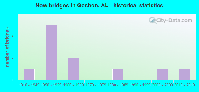
- New bridges - historical statistics
- 11940-1949
- 51950-1959
- 21960-1969
- 11980-1989
- 12000-2009
- 12010-2019

- Bridge Condition - Deck
- 25.0%Excellent
- 25.0%Very good
- 25.0%Good
- 25.0%Failed

- Bridge Condition - Superstructure
- 25.0%Excellent
- 25.0%Very good
- 25.0%Good
- 25.0%Serious

- Bridge Condition - Substructure
- 25.0%Excellent
- 50.0%Satisfactory
- 25.0%Serious

- Bridge Condition - Channel
- 9.1%Very good
- 9.1%Good
- 63.6%Satisfactory
- 18.2%Fair

- Bridge Condition - Culverts
- 57.1%Good
- 42.9%Satisfactory
Find on map >> Show street view
Structure Number: 2187, Location: SEC 13, T9N, R19E (Lat: 31.748333, Lng: -86.115000), Route carried "on" structure: County highway , Year Built: 1940, Status: Closed, Structure Length: 3.69m (12.11ft), Average Daily Traffic: 20 (year 2001), Average Future Daily Traffic: 25 (year 2027), Design Load: H 10, Features Intersected: LYNN MILL CREEK, Facility Carried by Structure: COUNTY ROAD 2219
Minimum Vertical Clearance: 30+ m (98+ ft), Kilometerpoint: 0.010, Lanes on structure: 1, Owner: County Highway Agency, Approaching Roadway Width: 5.5m (18.0ft), Material/Design: Wood or Timber, Design/Construction: Stringer/Multi-beam, Number Of Spans In Main Unit: 8, Length of Maximum Span: 4.6m (15.1ft), Curb-To-Curb Width: 4.3m (14.1ft), Out-to-Out Width: 4.6m (15.1ft)
Condition: Deck: Failed, Superstructure: Serious, Substructure: Serious, Channel: Satisfactory, Deck Geometry: Equal to present minimum criteria, Waterway Adequacy: Equal to present minimum criteria, Approach Roadway Alignment: High priority of corrective action, Bridge Posting: Required (Relationship of Operating Rating to Maximum Legal Load: > 39.9% below), Length Of Structure Improvement: 4.62m (15.16ft), Designated Inspection Frequency: Every 24 months, Other Special Inspection Frequency: Every 12 months, Inspection Date: October 2006, Other Special Inspection Date: March 2007, Bridge Improvement Cost: $475,000, Roadway Improvement Cost: $48,000, Total Project Cost: $523,000 ( Estimate for 2022), Deck Structure Type: Wood or Timber, Wearing Surface/Protective System: Wearing Surface: Wood or Timber
Find on map >> Show street view
Structure Number: 4285, Location: SEC 11,T9N,R19E (Lat: 31.763333, Lng: -86.126667), Route carried "on" structure: County highway 5, Year Built: 1952, Status: Open, Structure Length: 1.52m (4.99ft), Average Daily Traffic: 250 (year 2000), Truck Traffic: 6%, Average Future Daily Traffic: 300 (year 2035), Design Load: H 10, Features Intersected: MILL CREEK, Facility Carried by Structure: COUNTY ROAD 2201
Minimum Vertical Clearance: 30+ m (98+ ft), Kilometerpoint: 0.010, Lanes on structure: 2, Owner: County Highway Agency, Approaching Roadway Width: 7.3m (24.0ft), Material/Design: Concrete, Design/Construction: Culvert, Number Of Spans In Main Unit: 4, Length of Maximum Span: 3.7m (12.1ft), Curb-To-Curb Width: 14.1m (46.3ft), Out-to-Out Width: 14.6m (47.9ft)
Condition: Channel: Satisfactory, Culverts: Good, Operating Rating: 55.2 metric tons, Method Used To Determine Operating Rating: Load Factor (LF), Inventory Rating: 33.2 metric tons, Method Used To Determine Inventory Rating: Load Factor (LF), Structural Evaluation: Better than present minimum criteria, Deck Geometry: Superior to present desirable criteria, Waterway Adequacy: Better than present minimum criteria, Approach Roadway Alignment: Equal to present minimum criteria, Length Of Structure Improvement: 2.20m (7.22ft), Designated Inspection Frequency: Every 24 months, Inspection Date: September 2020, Bridge Improvement Cost: $610,000, Roadway Improvement Cost: $61,000, Total Project Cost: $671,000 ( Estimate for 2022)
Find on map >> Show street view
Structure Number: 4341, Location: SEC 26,T9N,R19E (Lat: 31.721667, Lng: -86.115000), Route carried "on" structure: County highway 28, Year Built: 1952, Status: Open, Structure Length: 1.22m (4.00ft), Average Daily Traffic: 1,500 (year 2000), Truck Traffic: 12%, Average Future Daily Traffic: 1,500 (year 2035), Design Load: H 10, Features Intersected: ELAM BRANCH, Facility Carried by Structure: COUNTY ROAD 2243
Minimum Vertical Clearance: 30+ m (98+ ft), Kilometerpoint: 0.010, Lanes on structure: 2, Owner: County Highway Agency, Approaching Roadway Width: 7.3m (24.0ft), Material/Design: Concrete, Design/Construction: Culvert, Number Of Spans In Main Unit: 4, Length of Maximum Span: 3.0m (9.8ft), Curb-To-Curb Width: 12.3m (40.4ft), Out-to-Out Width: 12.8m (42.0ft)
Condition: Channel: Satisfactory, Culverts: Good, Operating Rating: 50.8 metric tons, Method Used To Determine Operating Rating: Load Factor (LF), Inventory Rating: 30.5 metric tons, Method Used To Determine Inventory Rating: Load Factor (LF), Structural Evaluation: Better than present minimum criteria, Deck Geometry: Better than present minimum criteria, Waterway Adequacy: Better than present minimum criteria, Approach Roadway Alignment: Better than present minimum criteria, Length Of Structure Improvement: 1.89m (6.20ft), Designated Inspection Frequency: Every 24 months, Inspection Date: September 2020, Bridge Improvement Cost: $459,000, Roadway Improvement Cost: $46,000, Total Project Cost: $505,000 ( Estimate for 2022)
Find on map >> Show street view
Structure Number: 4402, Location: SEC 7,T8N,R20E (Lat: 31.683333, Lng: -86.088333), Route carried "on" structure: County highway 61, Year Built: 1952, Status: Open, Structure Length: 0.94m (3.08ft), Average Daily Traffic: 235 (year 2000), Truck Traffic: 7%, Average Future Daily Traffic: 300 (year 2036), Design Load: H 10, Features Intersected: WARRICK CREEK, Facility Carried by Structure: COUNTY ROAD 2246
Minimum Vertical Clearance: 30+ m (98+ ft), Kilometerpoint: 0.010, Lanes on structure: 2, Owner: County Highway Agency, Approaching Roadway Width: 7.3m (24.0ft), Material/Design: Concrete, Design/Construction: Culvert, Number Of Spans In Main Unit: 3, Length of Maximum Span: 3.0m (9.8ft)
Condition: Channel: Satisfactory, Culverts: Satisfactory, Operating Rating: 42.8 metric tons, Method Used To Determine Operating Rating: Load Factor (LF), Inventory Rating: 25.7 metric tons, Method Used To Determine Inventory Rating: Load Factor (LF), Structural Evaluation: Equal to present minimum criteria, Waterway Adequacy: Meets minimum limits, Approach Roadway Alignment: Equal to present minimum criteria, Length Of Structure Improvement: 1.61m (5.28ft), Designated Inspection Frequency: Every 24 months, Inspection Date: January 2021, Bridge Improvement Cost: $316,000, Roadway Improvement Cost: $32,000, Total Project Cost: $348,000 ( Estimate for 2022)
Find on map >> Show street view
Structure Number: 4403, Location: SEC 36,T9N,R19E (Lat: 31.705000, Lng: -86.100000), Route carried "on" structure: County highway 61, Year Built: 1952, Status: Open, Structure Length: 1.52m (4.99ft), Average Daily Traffic: 230 (year 2000), Truck Traffic: 10%, Average Future Daily Traffic: 300 (year 2035), Design Load: H 10, Features Intersected: SMILIES MILL CREEK, Facility Carried by Structure: COUNTY ROAD 2243
Minimum Vertical Clearance: 30+ m (98+ ft), Kilometerpoint: 0.010, Lanes on structure: 2, Owner: County Highway Agency, Approaching Roadway Width: 7.3m (24.0ft), Material/Design: Concrete, Design/Construction: Culvert, Number Of Spans In Main Unit: 4, Length of Maximum Span: 3.7m (12.1ft), Curb-To-Curb Width: 12.9m (42.3ft), Out-to-Out Width: 13.4m (44.0ft)
Condition: Channel: Satisfactory, Culverts: Satisfactory, Operating Rating: 65.8 metric tons, Method Used To Determine Operating Rating: Load Factor (LF), Inventory Rating: 39.5 metric tons, Method Used To Determine Inventory Rating: Load Factor (LF), Structural Evaluation: Equal to present minimum criteria, Deck Geometry: Superior to present desirable criteria, Waterway Adequacy: Better than present minimum criteria, Approach Roadway Alignment: Better than present minimum criteria, Length Of Structure Improvement: 2.20m (7.22ft), Designated Inspection Frequency: Every 24 months, Inspection Date: January 2021, Bridge Improvement Cost: $559,000, Roadway Improvement Cost: $56,000, Total Project Cost: $615,000 ( Estimate for 2022)
Find on map >> Show street view
Structure Number: 5462, Location: SEC 10,T8N,R19E (Lat: 31.686667, Lng: -86.133333), Route carried "on" structure: County highway 5, Year Built: 1956, Status: Open, Structure Length: 1.28m (4.20ft), Average Daily Traffic: 280 (year 2000), Truck Traffic: 5%, Average Future Daily Traffic: 300 (year 2035), Design Load: H 10, Features Intersected: BROAD HEAD CREEK, Facility Carried by Structure: COUNTY ROAD 2241
Minimum Vertical Clearance: 30+ m (98+ ft), Kilometerpoint: 0.010, Lanes on structure: 2, Owner: County Highway Agency, Approaching Roadway Width: 7.3m (24.0ft), Skew: 4 degrees, Material/Design: Concrete, Design/Construction: Culvert, Number Of Spans In Main Unit: 3, Length of Maximum Span: 4.3m (14.1ft), Curb-To-Curb Width: 9.8m (32.2ft), Out-to-Out Width: 10.4m (34.1ft)
Condition: Channel: Fair, Culverts: Good, Operating Rating: 63.3 metric tons, Method Used To Determine Operating Rating: Load Factor (LF), Inventory Rating: 37.9 metric tons, Method Used To Determine Inventory Rating: Load Factor (LF), Structural Evaluation: Better than present minimum criteria, Deck Geometry: Better than present minimum criteria, Waterway Adequacy: Equal to present minimum criteria, Approach Roadway Alignment: Equal to present minimum criteria, Length Of Structure Improvement: 1.95m (6.40ft), Designated Inspection Frequency: Every 24 months, Inspection Date: December 2020, Bridge Improvement Cost: $384,000, Roadway Improvement Cost: $38,000, Total Project Cost: $422,000 ( Estimate for 2022)
Find on map >> Show street view
Structure Number: 9101, Location: SEC 22,T9N,R19E (Lat: 31.741667, Lng: -86.138333), Route carried "on" structure: County highway 42, Year Built: 1966, Status: Open, Structure Length: 0.99m (3.25ft), Average Daily Traffic: 100 (year 2000), Average Future Daily Traffic: 100 (year 2035), Design Load: H 10, Features Intersected: ROBERTSON BRANCH, Facility Carried by Structure: COUNTY ROAD 2219
Minimum Vertical Clearance: 30+ m (98+ ft), Kilometerpoint: 0.010, Lanes on structure: 2, Owner: County Highway Agency, Approaching Roadway Width: 7.9m (25.9ft), Skew: 4 degrees, Material/Design: Concrete, Design/Construction: Culvert, Number Of Spans In Main Unit: 3, Length of Maximum Span: 3.0m (9.8ft)
Condition: Channel: Fair, Culverts: Satisfactory, Operating Rating: 54.9 metric tons, Method Used To Determine Operating Rating: Load Factor (LF), Inventory Rating: 32.9 metric tons, Method Used To Determine Inventory Rating: Load Factor (LF), Structural Evaluation: Equal to present minimum criteria, Waterway Adequacy: Equal to present minimum criteria, Approach Roadway Alignment: Better than present minimum criteria, Length Of Structure Improvement: 1.66m (5.45ft), Designated Inspection Frequency: Every 24 months, Inspection Date: Febuary 2021, Bridge Improvement Cost: $403,000, Roadway Improvement Cost: $40,000, Total Project Cost: $443,000 ( Estimate for 2022), Deck Structure Type: Concrete Cast-file-Place
Find on map >> Show street view
Structure Number: 9776, Location: SEC 12, T8N, R19N (Lat: 31.681667, Lng: -86.104264), Route carried "on" structure: County highway 101, Year Built: 1968, Status: Posted for load, Structure Length: 2.90m (9.51ft), Average Daily Traffic: 200 (year 2000), Truck Traffic: 8%, Average Future Daily Traffic: 200 (year 2034), Design Load: H 15, Features Intersected: WARRICK CREEK, Facility Carried by Structure: COUNTY ROAD 2243
Minimum Vertical Clearance: 30+ m (98+ ft), Kilometerpoint: 0.010, Lanes on structure: 2, Owner: County Highway Agency, Approaching Roadway Width: 8.5m (27.9ft), Material/Design: Concrete, Design/Construction: Channel Beam, Number Of Spans In Main Unit: 5, Length of Maximum Span: 5.8m (19.0ft), Curb-To-Curb Width: 7.4m (24.3ft), Out-to-Out Width: 7.8m (25.6ft)
Condition: Deck: Good, Superstructure: Good, Substructure: Satisfactory, Channel: Satisfactory, Operating Rating: 39.7 metric tons, Method Used To Determine Operating Rating: Load Factor (LF), Inventory Rating: 23.9 metric tons, Method Used To Determine Inventory Rating: Load Factor (LF), Structural Evaluation: Equal to present minimum criteria, Deck Geometry: Somewhat better than minimum adequacy, Waterway Adequacy: Better than present minimum criteria, Approach Roadway Alignment: Equal to present minimum criteria, Bridge Posting: Required (Relationship of Operating Rating to Maximum Legal Load: 0.1 - 9.9% below), Length Of Structure Improvement: 3.81m (12.50ft), Designated Inspection Frequency: Every 24 months, Other Special Inspection Frequency: Every 12 months, Inspection Date: January 2022, Other Special Inspection Date: January 2022, Bridge Improvement Cost: $653,000, Roadway Improvement Cost: $65,000, Total Project Cost: $718,000 ( Estimate for 2022), Deck Structure Type: Concrete Precast Panels
Find on map >> Show street view
Structure Number: 1331, Location: SEC 25,T9N,R19E (Lat: 31.719536, Lng: -86.107317), Route carried "on" structure: County highway 28, Year Built: 1984, Status: Open, Structure Length: 22.46m (73.69ft), Average Daily Traffic: 1,500 (year 2000), Truck Traffic: 6%, Average Future Daily Traffic: 1,500 (year 2035), Design Load: HS 20, Features Intersected: CONECUH RIVER, Facility Carried by Structure: COUNTY ROAD 2243
Minimum Vertical Clearance: 30+ m (98+ ft), Kilometerpoint: 0.010, Lanes on structure: 2, Owner: County Highway Agency, Approaching Roadway Width: 11.6m (38.1ft), Material/Design: Steel continuous, Design/Construction: Stringer/Multi-beam, Number Of Spans In Main Unit: 3, Number Of Approach Spans: 14, Length of Maximum Span: 30.5m (100.1ft), Curb or Sidewalk Widths: Left: 0.2m (0.7ft), Right: 0.2m (0.7ft), Curb-To-Curb Width: 8.5m (27.9ft), Out-to-Out Width: 9.4m (30.8ft)
Condition: Deck: Very good, Superstructure: Very good, Substructure: Satisfactory, Channel: Good, Operating Rating: 57.5 metric tons, Method Used To Determine Operating Rating: Load Factor (LF), Inventory Rating: 34.8 metric tons, Method Used To Determine Inventory Rating: Load Factor (LF), Structural Evaluation: Equal to present minimum criteria, Deck Geometry: Somewhat better than minimum adequacy, Waterway Adequacy: Equal to present desirable criteria, Approach Roadway Alignment: Equal to present minimum criteria, Length Of Structure Improvement: 22.46m (73.69ft), Designated Inspection Frequency: Every 24 months, Inspection Date: Febuary 2021, Bridge Improvement Cost: $4,620,000, Roadway Improvement Cost: $462,000, Total Project Cost: $5,082,000 ( Estimate for 2022), Deck Structure Type: Concrete Cast-file-Place
Find on map >> Show street view
Structure Number: 17999, Location: SEC 14, T9N, R19E (Lat: 31.753575, Lng: -86.115667), Route carried "on" structure: County highway 25, Year Built: 2001, Status: Open, Structure Length: 1.55m (5.09ft), Average Daily Traffic: 630 (year 2001), Average Future Daily Traffic: 940 (year 2035), Design Load: HS 20, Features Intersected: MILL CREEK, Facility Carried by Structure: COUNTY ROAD 2214
Minimum Vertical Clearance: 30.18m (99.02ft), Kilometerpoint: 0.000, Lanes on structure: 2, Owner: County Highway Agency, Approaching Roadway Width: 7.3m (24.0ft), Material/Design: Concrete, Design/Construction: Culvert, Number Of Spans In Main Unit: 4, Length of Maximum Span: 3.7m (12.1ft), Curb-To-Curb Width: 12.9m (42.3ft), Out-to-Out Width: 13.4m (44.0ft)
Condition: Channel: Satisfactory, Culverts: Good, Operating Rating: 50.4 metric tons, Method Used To Determine Operating Rating: Load Factor (LF), Inventory Rating: 30.2 metric tons, Method Used To Determine Inventory Rating: Load Factor (LF), Structural Evaluation: Better than present minimum criteria, Deck Geometry: Superior to present desirable criteria, Waterway Adequacy: Equal to present desirable criteria, Approach Roadway Alignment: Equal to present desirable criteria, Length Of Structure Improvement: 2.24m (7.35ft), Designated Inspection Frequency: Every 24 months, Inspection Date: October 2020, Bridge Improvement Cost: $569,000, Roadway Improvement Cost: $57,000, Total Project Cost: $626,000 ( Estimate for 2022), Deck Structure Type: Concrete Cast-file-Place
Find on map >> Show street view
Structure Number: 21381, Location: SEC 28, T9N, R29E (Lat: 31.731667, Lng: -86.121667), Route carried "on" structure: County highway 5, Year Built: 2017, Status: Open, Structure Length: 3.66m (12.01ft), Average Daily Traffic: 1,080 (year 2017), Truck Traffic: 10%, Average Future Daily Traffic: 1,190 (year 2037), Design Load: HS 20, Features Intersected: ROBERTSON BRANCH, Facility Carried by Structure: COUNTY ROAD 2201
Minimum Vertical Clearance: 30+ m (98+ ft), Kilometerpoint: 0.010, Lanes on structure: 2, Owner: County Highway Agency, Approaching Roadway Width: 9.1m (29.9ft), Material/Design: Concrete, Design/Construction: Channel Beam, Number Of Spans In Main Unit: 3, Length of Maximum Span: 12.2m (40.0ft), Curb-To-Curb Width: 6.1m (20.0ft), Out-to-Out Width: 8.5m (27.9ft)
Condition: Deck: Excellent, Superstructure: Excellent, Substructure: Excellent, Channel: Very good, Operating Rating: 88.9 metric tons, Method Used To Determine Operating Rating: Load Factor (LF), Inventory Rating: 54.5 metric tons, Method Used To Determine Inventory Rating: Load Factor (LF), Structural Evaluation: Superior to present desirable criteria, Deck Geometry: High priority of replacement, Waterway Adequacy: Superior to present desirable criteria, Approach Roadway Alignment: Equal to present desirable criteria, Length Of Structure Improvement: 4.58m (15.03ft), Designated Inspection Frequency: Every 24 months, Inspection Date: October 2021, Bridge Improvement Cost: $879,000, Roadway Improvement Cost: $88,000, Total Project Cost: $967,000 ( Estimate for 2022), Deck Structure Type: Concrete Precast Panels