Bridge Statistics for Grand Detour, Illinois (IL)
Condition, Traffic, Stress, Structural Evaluation, Project Costs
- National Bridge Inventory (NBI) Statistics
- 12Number of bridges
- 187ft / 57.5mTotal length
- $1,524,000Total costs
- 17,275Total average daily traffic
- 874Total average daily truck traffic
- 23,500Total future (year 2040) average daily traffic
- National Bridge Inventory (NBI) Registered Bridges for Grand Detour
- No street view available for this location
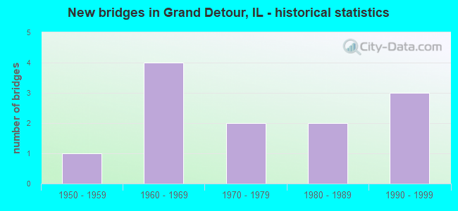
- New bridges - historical statistics
- 11950-1959
- 41960-1969
- 21970-1979
- 21980-1989
- 31990-1999


- Bridge Condition - Deck
- 9.1%Very good
- 27.3%Good
- 27.3%Satisfactory
- 9.1%Fair
- 27.3%Poor

- Bridge Condition - Superstructure
- 18.2%Very good
- 36.4%Good
- 18.2%Satisfactory
- 27.3%Poor

- Bridge Condition - Substructure
- 27.3%Very good
- 36.4%Good
- 9.1%Satisfactory
- 18.2%Fair
- 9.1%Poor

- Bridge Condition - Channel
- 16.7%Very good
- 25.0%Good
- 33.3%Satisfactory
- 25.0%Fair
Find on map >> Show street view
Structure Number: 520063, Location: AT GRAND DETOUR (Lat: 41.890861, Lng: -89.418661), Route carried "on" structure: State highway 2, Year Built: 1994, Status: Open, Structure Length: 31.47m (103.25ft), Average Daily Traffic: 5,050 (year 2021), Truck Traffic: 9%, Average Future Daily Traffic: 8,400 (year 2040), Design Load: HS 20+Mod, Features Intersected: ROCK RIVER
Minimum Vertical Clearance: 30+ m (98+ ft), Kilometerpoint: 28.935, Lanes on structure: 2, Base Highway Network: Yes, Owner: State Highway Agency, Approaching Roadway Width: 12.2m (40.0ft), Skew: 1 degrees, Navigation Control: Yes ( Vertical Clearance: 4.6m (15.1ft), Horizontal Clearance: 87.2m (286.1ft)), Material/Design: Steel continuous, Design/Construction: Stringer/Multi-beam, Number Of Spans In Main Unit: 4, Length of Maximum Span: 88.4m (290.0ft), Curb-To-Curb Width: 12.2m (40.0ft), Out-to-Out Width: 12.9m (42.3ft)
Condition: Deck: Satisfactory, Superstructure: Good, Substructure: Good, Channel: Good, Operating Rating: 64.8 metric tons, Method Used To Determine Operating Rating: Load Factor (LF) rating reported by rating factor (RF) method using MS18 loading, Inventory Rating: 43.1 metric tons, Method Used To Determine Inventory Rating: Load Factor (LF) rating reported by rating factor (RF) method using MS18 loading, Structural Evaluation: Better than present minimum criteria, Deck Geometry: Somewhat better than minimum adequacy, Waterway Adequacy: Equal to present desirable criteria, Approach Roadway Alignment: Equal to present desirable criteria, Designated Inspection Frequency: Every 24 months, Underwater Inspection Frequency: Every 48 months, Inspection Date: June 2020, Underwater Inspection Date: June 2018, Deck Structure Type: Concrete Cast-file-Place, Wearing Surface/Protective System: Deck Protection: Epoxy Coated Reinforcing
Find on map >> Show street view
Structure Number: 52369, Location: 0.7 MI E ILL RT 2 (Lat: 41.866386, Lng: -89.415314), Route carried "on" structure: County highway , Year Built: 1963, Status: Open, Structure Length: 2.37m (7.78ft), Average Daily Traffic: 2,500 (year 2017), Average Future Daily Traffic: 3,000 (year 2040), Design Load: HS 15, Features Intersected: ROCK RIVER TRIBUTARY, Facility Carried by Structure: CH 1 LOST NATION R
Minimum Vertical Clearance: 30+ m (98+ ft), Kilometerpoint: 1.175, Lanes on structure: 2, Owner: County Highway Agency, Approaching Roadway Width: 10.4m (34.1ft), Skew: 3 degrees, Material/Design: Concrete continuous, Design/Construction: Slab, Number Of Spans In Main Unit: 3, Length of Maximum Span: 8.6m (28.2ft), Curb-To-Curb Width: 7.9m (25.9ft), Out-to-Out Width: 9.2m (30.2ft)
Condition: Deck: Satisfactory, Superstructure: Satisfactory, Substructure: Fair, Channel: Good, Operating Rating: 47.3 metric tons, Method Used To Determine Operating Rating: Load Factor (LF) rating reported by rating factor (RF) method using MS18 loading, Inventory Rating: 28.2 metric tons, Method Used To Determine Inventory Rating: Load Factor (LF) rating reported by rating factor (RF) method using MS18 loading, Structural Evaluation: Somewhat better than minimum adequacy, Deck Geometry: High priority of corrective action, Waterway Adequacy: Equal to present desirable criteria, Approach Roadway Alignment: Equal to present desirable criteria, Length Of Structure Improvement: 3.08m (10.10ft), Designated Inspection Frequency: Every 24 months, Inspection Date: Febuary 2021, Bridge Improvement Cost: $250,000, Roadway Improvement Cost: $25,000, Total Project Cost: $375,000, Deck Structure Type: Concrete Cast-file-Place, Wearing Surface/Protective System: Wearing Surface: Bituminous, Membrane: Built-up
Find on map >> Show street view
Structure Number: 523691, Location: 1.7 MI S OF OGLE CO (Lat: 41.876467, Lng: -89.400386), Route carried "on" structure: County highway , Year Built: 1963, Status: Open, Structure Length: 2.68m (8.79ft), Average Daily Traffic: 2,500 (year 2017), Average Future Daily Traffic: 3,700 (year 2040), Design Load: HS 15, Features Intersected: CHAMBERLAIN CREEK, Facility Carried by Structure: CH 1 LOST NATION R
Minimum Vertical Clearance: 30+ m (98+ ft), Kilometerpoint: 2.993, Lanes on structure: 2, Owner: County Highway Agency, Approaching Roadway Width: 10.4m (34.1ft), Skew: 3 degrees, Material/Design: Concrete, Design/Construction: Slab, Number Of Spans In Main Unit: 3, Length of Maximum Span: 9.8m (32.2ft), Curb-To-Curb Width: 8.1m (26.6ft), Out-to-Out Width: 9.4m (30.8ft)
Condition: Deck: Satisfactory, Superstructure: Satisfactory, Substructure: Fair, Channel: Fair, Operating Rating: 44.7 metric tons, Method Used To Determine Operating Rating: Load Factor (LF) rating reported by rating factor (RF) method using MS18 loading, Inventory Rating: 26.9 metric tons, Method Used To Determine Inventory Rating: Load Factor (LF) rating reported by rating factor (RF) method using MS18 loading, Structural Evaluation: Somewhat better than minimum adequacy, Deck Geometry: High priority of corrective action, Waterway Adequacy: Equal to present desirable criteria, Approach Roadway Alignment: Better than present minimum criteria, Length Of Structure Improvement: 3.47m (11.38ft), Designated Inspection Frequency: Every 24 months, Inspection Date: Febuary 2020, Bridge Improvement Cost: $288,000, Roadway Improvement Cost: $29,000, Total Project Cost: $432,000, Deck Structure Type: Concrete Cast-file-Place, Wearing Surface/Protective System: Wearing Surface: Bituminous, Membrane: Built-up
Find on map >> Show street view
Structure Number: 523692, Location: 0.8 MI S OF OGLE CO (Lat: 41.891206, Lng: -89.395664), Route carried "on" structure: County highway , Year Built: 1957, Year Reconstructed: 2002, Status: Open, Structure Length: 4.57m (14.99ft), Average Daily Traffic: 2,500 (year 2017), Average Future Daily Traffic: 3,100 (year 2040), Design Load: HS 20, Features Intersected: FRANKLIN CREEK, Facility Carried by Structure: CH 1 LOST NATION R
Minimum Vertical Clearance: 30+ m (98+ ft), Kilometerpoint: 4.715, Lanes on structure: 2, Owner: County Highway Agency, Approaching Roadway Width: 10.4m (34.1ft), Material/Design: Prestressed concrete, Design/Construction: Box Beam or Girders - Multiple, Number Of Spans In Main Unit: 3, Length of Maximum Span: 15.2m (49.9ft), Curb-To-Curb Width: 9.1m (29.9ft), Out-to-Out Width: 9.1m (29.9ft)
Condition: Deck: Good, Superstructure: Good, Substructure: Poor, Channel: Very good, Operating Rating: 76.8 metric tons, Method Used To Determine Operating Rating: Load Factor (LF) rating reported by rating factor (RF) method using MS18 loading, Inventory Rating: 46.0 metric tons, Method Used To Determine Inventory Rating: Load Factor (LF) rating reported by rating factor (RF) method using MS18 loading, Structural Evaluation: Meets minimum limits, Deck Geometry: Meets minimum limits, Waterway Adequacy: Equal to present desirable criteria, Approach Roadway Alignment: Equal to present desirable criteria, Length Of Structure Improvement: 5.49m (18.01ft), Designated Inspection Frequency: Every 24 months, Inspection Date: Febuary 2020, Bridge Improvement Cost: $478,000, Roadway Improvement Cost: $48,000, Total Project Cost: $717,000, Deck Structure Type: Concrete Precast Panels, Wearing Surface/Protective System: Wearing Surface: Bituminous, Membrane: Built-up
Find on map >> Show street view
Structure Number: 524441, Location: 1.2 MI N OF ILL 38 (Lat: 41.854656, Lng: -89.390103), Route carried "on" structure: County highway , Year Built: 1971, Status: Open, Structure Length: 1.13m (3.71ft), Average Daily Traffic: 75 (year 2017), Truck Traffic: 1%, Average Future Daily Traffic: 75 (year 2040), Design Load: HS 15, Features Intersected: CHAMBERLAN CREEK, Facility Carried by Structure: NACHUSA RD
Minimum Vertical Clearance: 30+ m (98+ ft), Kilometerpoint: 2.913, Lanes on structure: 2, Owner: Town or Township Highway Agency, Approaching Roadway Width: 6.7m (22.0ft), Material/Design: Concrete, Design/Construction: Slab, Number Of Spans In Main Unit: 1, Length of Maximum Span: 9.8m (32.2ft), Curb-To-Curb Width: 7.2m (23.6ft), Out-to-Out Width: 7.8m (25.6ft)
Condition: Deck: Good, Superstructure: Good, Substructure: Satisfactory, Channel: Fair, Operating Rating: 40.5 metric tons, Method Used To Determine Operating Rating: Field evaluation and documented engineering judgment, Inventory Rating: 24.3 metric tons, Method Used To Determine Inventory Rating: Field evaluation and documented engineering judgment, Structural Evaluation: Equal to present minimum criteria, Deck Geometry: Somewhat better than minimum adequacy, Waterway Adequacy: Better than present minimum criteria, Approach Roadway Alignment: Better than present minimum criteria, Designated Inspection Frequency: Every 24 months, Inspection Date: Febuary 2021, Deck Structure Type: Concrete Cast-file-Place, Wearing Surface/Protective System: Wearing Surface: Bituminous
Find on map >> Show street view
Structure Number: 524447, Location: 1.8 MI. E. OF IL 2 (Lat: 41.866436, Lng: -89.394903), Route carried "on" structure: County highway , Year Built: 1992, Status: Open, Structure Length: 1.57m (5.15ft), Average Daily Traffic: 400 (year 2017), Truck Traffic: 1%, Average Future Daily Traffic: 650 (year 2040), Design Load: HS 20, Features Intersected: CHAMBERLAIN CREEK, Facility Carried by Structure: NAYLOR ROAD (TR61)
Minimum Vertical Clearance: 30+ m (98+ ft), Kilometerpoint: 1.207, Lanes on structure: 2, Owner: Town or Township Highway Agency, Approaching Roadway Width: 7.3m (24.0ft), Material/Design: Prestressed concrete, Design/Construction: Box Beam or Girders - Multiple, Number Of Spans In Main Unit: 1, Length of Maximum Span: 14.9m (48.9ft), Curb-To-Curb Width: 8.5m (27.9ft), Out-to-Out Width: 8.5m (27.9ft)
Condition: Deck: Poor, Superstructure: Poor, Substructure: Very good, Channel: Good, Operating Rating: 61.2 metric tons, Method Used To Determine Operating Rating: Load Factor (LF) rating reported by rating factor (RF) method using MS18 loading, Inventory Rating: 36.6 metric tons, Method Used To Determine Inventory Rating: Load Factor (LF) rating reported by rating factor (RF) method using MS18 loading, Structural Evaluation: Meets minimum limits, Deck Geometry: Equal to present minimum criteria, Waterway Adequacy: Equal to present desirable criteria, Approach Roadway Alignment: Equal to present desirable criteria, Designated Inspection Frequency: Every 24 months, Inspection Date: Febuary 2021, Deck Structure Type: Concrete Precast Panels
Find on map >> Show street view
Structure Number: 52543, Location: 1.0 MI SE OF ILL 2 (Lat: 41.878803, Lng: -89.413811), Route carried "on" structure: County highway , Year Built: 1969, Status: Open, Structure Length: 0.91m (2.99ft), Average Daily Traffic: 200 (year 2017), Truck Traffic: 16%, Average Future Daily Traffic: 200 (year 2040), Design Load: HS 15, Features Intersected: MOORE CREEK, Facility Carried by Structure: GRAND DETOUR RD
Minimum Vertical Clearance: 30+ m (98+ ft), Kilometerpoint: 3.058, Lanes on structure: 2, Owner: Town or Township Highway Agency, Approaching Roadway Width: 9.1m (29.9ft), Material/Design: Steel, Design/Construction: Culvert, Number Of Spans In Main Unit: 2, Length of Maximum Span: 4.1m (13.5ft)
Condition: Channel: Fair, Culverts: Good, Operating Rating: 40.5 metric tons, Method Used To Determine Operating Rating: Field evaluation and documented engineering judgment, Inventory Rating: 24.3 metric tons, Method Used To Determine Inventory Rating: Field evaluation and documented engineering judgment, Structural Evaluation: Equal to present minimum criteria, Waterway Adequacy: Equal to present desirable criteria, Approach Roadway Alignment: Equal to present desirable criteria, Designated Inspection Frequency: Every 24 months, Inspection Date: Febuary 2020
Find on map >> Show street view
Structure Number: 710072, Location: 2 MI N GRAND DETOUR (Lat: 41.918306, Lng: -89.398158), Route carried "on" structure: State highway 2, Year Built: 1984, Status: Open, Structure Length: 2.65m (8.69ft), Average Daily Traffic: 3,600 (year 2021), Truck Traffic: 10%, Average Future Daily Traffic: 3,800 (year 2040), Design Load: HS 20+Mod, Features Intersected: DRAINAGE DITCH
Minimum Vertical Clearance: 30+ m (98+ ft), Kilometerpoint: 32.540, Lanes on structure: 2, Base Highway Network: Yes, Owner: State Highway Agency, Approaching Roadway Width: 11.0m (36.1ft), Skew: 2 degrees, Material/Design: Prestressed concrete, Design/Construction: Stringer/Multi-beam, Number Of Spans In Main Unit: 1, Length of Maximum Span: 24.8m (81.4ft), Curb-To-Curb Width: 11.0m (36.1ft), Out-to-Out Width: 11.9m (39.0ft)
Condition: Deck: Fair, Superstructure: Very good, Substructure: Very good, Channel: Very good, Operating Rating: 82.3 metric tons, Method Used To Determine Operating Rating: Load Factor (LF) rating reported by rating factor (RF) method using MS18 loading, Inventory Rating: 43.4 metric tons, Method Used To Determine Inventory Rating: Load Factor (LF) rating reported by rating factor (RF) method using MS18 loading, Structural Evaluation: Equal to present desirable criteria, Deck Geometry: Somewhat better than minimum adequacy, Waterway Adequacy: Equal to present desirable criteria, Approach Roadway Alignment: Equal to present desirable criteria, Designated Inspection Frequency: Every 24 months, Inspection Date: August 2020, Deck Structure Type: Concrete Cast-file-Place, Wearing Surface/Protective System: Deck Protection: Epoxy Coated Reinforcing
Find on map >> Show street view
Structure Number: 713035, Location: 4.5 MI NW GRAND DET (Lat: 41.943808, Lng: -89.451031), Route carried "on" structure: County highway , Year Built: 1961, Status: Open, Structure Length: 2.50m (8.20ft), Average Daily Traffic: 225 (year 2017), Truck Traffic: 10%, Average Future Daily Traffic: 300 (year 2040), Design Load: HS 15, Features Intersected: PINE CREEK, Facility Carried by Structure: PENN CORNER RD
Minimum Vertical Clearance: 30+ m (98+ ft), Kilometerpoint: 3.573, Lanes on structure: 2, Owner: County Highway Agency, Approaching Roadway Width: 10.4m (34.1ft), Material/Design: Concrete continuous, Design/Construction: Slab, Number Of Spans In Main Unit: 2, Length of Maximum Span: 12.2m (40.0ft), Curb-To-Curb Width: 7.3m (24.0ft), Out-to-Out Width: 8.6m (28.2ft)
Condition: Deck: Poor, Superstructure: Poor, Substructure: Good, Channel: Satisfactory, Operating Rating: 52.8 metric tons, Method Used To Determine Operating Rating: Load Factor (LF) rating reported by rating factor (RF) method using MS18 loading, Inventory Rating: 31.8 metric tons, Method Used To Determine Inventory Rating: Load Factor (LF) rating reported by rating factor (RF) method using MS18 loading, Structural Evaluation: Meets minimum limits, Deck Geometry: Somewhat better than minimum adequacy, Waterway Adequacy: Superior to present desirable criteria, Approach Roadway Alignment: Equal to present desirable criteria, Designated Inspection Frequency: Every 24 months, Inspection Date: August 2021, Deck Structure Type: Concrete Cast-file-Place, Wearing Surface/Protective System: Wearing Surface: Other
Find on map >> Show street view
Structure Number: 713228, Location: 3.0 NW GRAND DETOUR (Lat: 41.927597, Lng: -89.449867), Route carried "on" structure: County highway , Year Built: 1977, Status: Open, Structure Length: 2.44m (8.01ft), Average Daily Traffic: 125 (year 2017), Truck Traffic: 2%, Average Future Daily Traffic: 150 (year 2040), Design Load: HS 20, Features Intersected: PINE CREEK, Facility Carried by Structure: EDGEWOOD ROAD
Minimum Vertical Clearance: 30+ m (98+ ft), Kilometerpoint: 4.216, Lanes on structure: 2, Owner: Town or Township Highway Agency, Approaching Roadway Width: 6.1m (20.0ft), Material/Design: Concrete continuous, Design/Construction: Slab, Number Of Spans In Main Unit: 3, Length of Maximum Span: 9.1m (29.9ft), Curb-To-Curb Width: 7.9m (25.9ft), Out-to-Out Width: 8.5m (27.9ft)
Condition: Deck: Very good, Superstructure: Very good, Substructure: Good, Channel: Satisfactory, Operating Rating: 44.4 metric tons, Method Used To Determine Operating Rating: Assigned rating based on Load Factor Design (LFD) reported by rating factor (RF) using MS18 loading, Inventory Rating: 32.4 metric tons, Method Used To Determine Inventory Rating: Assigned rating based on Load Factor Design (LFD) reported by rating factor (RF) using MS18 loading, Structural Evaluation: Better than present minimum criteria, Deck Geometry: Somewhat better than minimum adequacy, Waterway Adequacy: Equal to present desirable criteria, Approach Roadway Alignment: Better than present minimum criteria, Designated Inspection Frequency: Every 48 months, Inspection Date: August 2021, Deck Structure Type: Concrete Cast-file-Place
Find on map >> Show street view
Structure Number: 713252, Location: 8.0 M SW OF OREGON (Lat: 41.959811, Lng: -89.448675), Route carried "on" structure: County highway , Year Built: 1982, Status: Open, Structure Length: 4.27m (14.01ft), Average Daily Traffic: 50 (year 2017), Average Future Daily Traffic: 75 (year 2040), Design Load: HS 20, Features Intersected: PINE CREEK, Facility Carried by Structure: HENRY RD - TR 311
Minimum Vertical Clearance: 30+ m (98+ ft), Kilometerpoint: 14.934, Lanes on structure: 2, Owner: Town or Township Highway Agency, Approaching Roadway Width: 8.5m (27.9ft), Skew: 3 degrees, Material/Design: Prestressed concrete, Design/Construction: Box Beam or Girders - Multiple, Number Of Spans In Main Unit: 3, Length of Maximum Span: 14.0m (45.9ft), Curb-To-Curb Width: 7.3m (24.0ft), Out-to-Out Width: 7.3m (24.0ft)
Condition: Deck: Poor, Superstructure: Poor, Substructure: Very good, Channel: Satisfactory, Operating Rating: 44.4 metric tons, Method Used To Determine Operating Rating: Assigned rating based on Load Factor Design (LFD) reported by rating factor (RF) using MS18 loading, Inventory Rating: 32.4 metric tons, Method Used To Determine Inventory Rating: Assigned rating based on Load Factor Design (LFD) reported by rating factor (RF) using MS18 loading, Structural Evaluation: Meets minimum limits, Deck Geometry: Equal to present minimum criteria, Waterway Adequacy: Equal to present desirable criteria, Approach Roadway Alignment: Equal to present desirable criteria, Designated Inspection Frequency: Every 24 months, Inspection Date: August 2021, Deck Structure Type: Concrete Precast Panels
Find on map >> Show street view
Structure Number: 713321, Location: 4 MI N GRAND DETOUR (Lat: 41.957631, Lng: -89.420686), Route carried "on" structure: County highway , Year Built: 1999, Status: Open, Structure Length: 0.90m (2.95ft), Average Daily Traffic: 50 (year 2017), Average Future Daily Traffic: 50 (year 2040), Design Load: HS 20, Features Intersected: BR. OF PINE CREEK, Facility Carried by Structure: BUTTERNUT RD
Minimum Vertical Clearance: 30+ m (98+ ft), Kilometerpoint: 2.124, Lanes on structure: 2, Owner: Town or Township Highway Agency, Approaching Roadway Width: 8.5m (27.9ft), Material/Design: Prestressed concrete, Design/Construction: Box Beam or Girders - Multiple, Number Of Spans In Main Unit: 1, Length of Maximum Span: 8.6m (28.2ft), Curb-To-Curb Width: 7.3m (24.0ft), Out-to-Out Width: 7.3m (24.0ft)
Condition: Deck: Good, Superstructure: Good, Substructure: Good, Channel: Satisfactory, Operating Rating: 44.1 metric tons, Method Used To Determine Operating Rating: Assigned rating based on Load Factor Design (LFD) reported by rating factor (RF) using MS18 loading, Inventory Rating: 32.4 metric tons, Method Used To Determine Inventory Rating: Assigned rating based on Load Factor Design (LFD) reported by rating factor (RF) using MS18 loading, Structural Evaluation: Better than present minimum criteria, Deck Geometry: Equal to present minimum criteria, Waterway Adequacy: Better than present minimum criteria, Approach Roadway Alignment: Equal to present desirable criteria, Designated Inspection Frequency: Every 48 months, Inspection Date: August 2021, Deck Structure Type: Concrete Precast Panels