Bridge Statistics for Grand View, Idaho (ID)
Condition, Traffic, Stress, Structural Evaluation, Project Costs
- National Bridge Inventory (NBI) Statistics
- 10Number of bridges
- 95ft / 29.3mTotal length
- $1,518,000Total costs
- 5,525Total average daily traffic
- 559Total average daily truck traffic
- 8,288Total future (year 2039) average daily traffic
- National Bridge Inventory (NBI) Registered Bridges for Grand View
- No street view available for this location
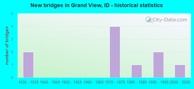
- New bridges - historical statistics
- 21930-1939
- 41970-1979
- 11980-1989
- 21990-1999
- 12000-2009

- Reconstructed bridges - Historical Statistics
- 11970-1979
- 11980-1989


- Bridge Condition - Deck
- 40.0%Good
- 40.0%Satisfactory
- 10.0%Fair
- 10.0%Poor

- Bridge Condition - Superstructure
- 30.0%Good
- 40.0%Satisfactory
- 10.0%Fair
- 10.0%Poor
- 10.0%Serious

- Bridge Condition - Substructure
- 10.0%Very good
- 40.0%Good
- 40.0%Satisfactory
- 10.0%Fair

- Bridge Condition - Channel
- 40.0%Very good
- 40.0%Good
- 20.0%Satisfactory
Find on map >> Show street view
Structure Number: 19845, Location: IN GRANDVIEW (Lat: 42.983989, Lng: -116.097203), Route carried "on" structure: State highway 167, Year Built: 1970, Status: Open, Structure Length: 0.76m (2.49ft), Average Daily Traffic: 1,700 (year 2019), Truck Traffic: 9%, Average Future Daily Traffic: 2,550 (year 2039), Design Load: HS 20, Features Intersected: GRANDVIEW IRRIG.DIST.CNL
Minimum Vertical Clearance: 30+ m (98+ ft), Kilometerpoint: 0.072, Lanes on structure: 2, Owner: State Highway Agency, Approaching Roadway Width: 10.4m (34.1ft), Skew: 1 degrees, Material/Design: Concrete, Design/Construction: Frame, Number Of Spans In Main Unit: 1, Length of Maximum Span: 7.6m (24.9ft), Curb or Sidewalk Widths: Left: 0.3m (1.0ft), Right: 0.3m (1.0ft), Curb-To-Curb Width: 13.4m (44.0ft), Out-to-Out Width: 14.0m (45.9ft)
Condition: Deck: Satisfactory, Superstructure: Satisfactory, Substructure: Satisfactory, Channel: Good, Operating Rating: 59.0 metric tons, Method Used To Determine Operating Rating: Load Factor (LF), Inventory Rating: 35.4 metric tons, Method Used To Determine Inventory Rating: Load Factor (LF), Structural Evaluation: Equal to present minimum criteria, Deck Geometry: Equal to present desirable criteria, Waterway Adequacy: Equal to present desirable criteria, Approach Roadway Alignment: Equal to present desirable criteria, Designated Inspection Frequency: Every 48 months, Inspection Date: Febuary 2021, Deck Structure Type: Concrete Cast-file-Place, Wearing Surface/Protective System: Wearing Surface: Bituminous
Find on map >> Show street view
Structure Number: 1985, Location: 0.8 N. GRANDVIEW (Lat: 42.994778, Lng: -116.097306), Route carried "on" structure: State highway 167, Year Built: 1970, Status: Open, Structure Length: 18.71m (61.38ft), Average Daily Traffic: 1,400 (year 2019), Truck Traffic: 9%, Average Future Daily Traffic: 2,100 (year 2039), Design Load: HS 20, Features Intersected: SNAKE RIVER;GRANDVIEW BR
Minimum Vertical Clearance: 30+ m (98+ ft), Kilometerpoint: 1.276, Lanes on structure: 2, Owner: State Highway Agency, Approaching Roadway Width: 10.4m (34.1ft), Skew: 3 degrees, Material/Design: Prestressed concrete, Design/Construction: Stringer/Multi-beam, Number Of Spans In Main Unit: 6, Length of Maximum Span: 30.5m (100.1ft), Curb-To-Curb Width: 10.6m (34.8ft), Out-to-Out Width: 11.5m (37.7ft)
Condition: Deck: Good, Superstructure: Satisfactory, Substructure: Satisfactory, Channel: Satisfactory, Operating Rating: 49.9 metric tons, Method Used To Determine Operating Rating: Load Factor (LF), Inventory Rating: 29.9 metric tons, Method Used To Determine Inventory Rating: Load Factor (LF), Structural Evaluation: Equal to present minimum criteria, Deck Geometry: Equal to present minimum criteria, Waterway Adequacy: Equal to present desirable criteria, Approach Roadway Alignment: Equal to present desirable criteria, Designated Inspection Frequency: Every 24 months, Underwater Inspection Frequency: Every 60 months, Inspection Date: Febuary 2021, Underwater Inspection Date: September 2018, Deck Structure Type: Concrete Cast-file-Place, Wearing Surface/Protective System: Wearing Surface: Latex Concrete
Find on map >> Show street view
Structure Number: 19853, Location: 2.5 N. 0.3 E. GRANDVIEW (Lat: 43.026564, Lng: -116.091375), Route carried "on" structure: State highway 167, Year Built: 1994, Status: Open, Structure Length: 0.76m (2.49ft), Average Daily Traffic: 1,400 (year 2019), Truck Traffic: 9%, Average Future Daily Traffic: 2,100 (year 2039), Design Load: HS 25 or greater, Features Intersected: MIDDLE LINE CANAL
Minimum Vertical Clearance: 30+ m (98+ ft), Kilometerpoint: 5.294, Lanes on structure: 2, Owner: State Highway Agency, Approaching Roadway Width: 9.1m (29.9ft), Skew: 4 degrees, Material/Design: Concrete, Design/Construction: Frame, Number Of Spans In Main Unit: 1, Length of Maximum Span: 7.6m (24.9ft), Curb or Sidewalk Widths: Left: 0.3m (1.0ft), Right: 0.3m (1.0ft), Curb-To-Curb Width: 13.7m (44.9ft), Out-to-Out Width: 14.6m (47.9ft)
Condition: Deck: Good, Superstructure: Good, Substructure: Good, Channel: Satisfactory, Operating Rating: 87.1 metric tons, Method Used To Determine Operating Rating: Load Factor (LF), Inventory Rating: 52.6 metric tons, Method Used To Determine Inventory Rating: Load Factor (LF), Structural Evaluation: Better than present minimum criteria, Deck Geometry: Superior to present desirable criteria, Waterway Adequacy: Equal to present desirable criteria, Approach Roadway Alignment: Equal to present desirable criteria, Designated Inspection Frequency: Every 48 months, Inspection Date: Febuary 2021, Deck Structure Type: Concrete Cast-file-Place, Wearing Surface/Protective System: Wearing Surface: Bituminous, Deck Protection: Epoxy Coated Reinforcing
Find on map >> Show street view
Structure Number: 27786, Location: 2.1 N 1.0 E GRANDVIEW (Lat: 43.013611, Lng: -116.077500), Route carried "on" structure: County highway , Year Built: 2004, Status: Open, Structure Length: 1.10m (3.61ft), Average Daily Traffic: 200 (year 2019), Truck Traffic: 50%, Average Future Daily Traffic: 300 (year 2039), Design Load: HS 20, Features Intersected: MIDDLE LINE CANAL, Facility Carried by Structure: HAYLAND ROAD
Minimum Vertical Clearance: 30+ m (98+ ft), Kilometerpoint: 162.697, Lanes on structure: 2, Owner: Local Agency, Approaching Roadway Width: 7.2m (23.6ft), Skew: 5 degrees, Material/Design: Concrete, Design/Construction: Frame, Number Of Spans In Main Unit: 1, Length of Maximum Span: 11.0m (36.1ft), Curb-To-Curb Width: 9.6m (31.5ft), Out-to-Out Width: 12.2m (40.0ft)
Condition: Deck: Good, Superstructure: Good, Substructure: Very good, Channel: Very good, Inventory Rating: 65.3 metric tons, Method Used To Determine Inventory Rating: Load Factor (LF), Structural Evaluation: Better than present minimum criteria, Deck Geometry: Equal to present minimum criteria, Waterway Adequacy: Better than present minimum criteria, Approach Roadway Alignment: Equal to present desirable criteria, Designated Inspection Frequency: Every 48 months, Inspection Date: Febuary 2018, Deck Structure Type: Concrete Cast-file-Place, Wearing Surface/Protective System: Wearing Surface: Bituminous, Membrane: Built-up
Find on map >> Show street view
Structure Number: 282, Location: 1.8 N. 3.0 W. GRAND VIEW (Lat: 43.008661, Lng: -116.156361), Route carried "on" structure: County highway , Year Built: 1930, Year Reconstructed: 1981, Status: Open, Structure Length: 0.70m (2.30ft), Average Daily Traffic: 65 (year 2019), Truck Traffic: 10%, Average Future Daily Traffic: 98 (year 2039), Design Load: HS 20, Features Intersected: GRAND VIEW IRRG.DIST.CNL, Facility Carried by Structure: BEET DUMP ROAD
Minimum Vertical Clearance: 30+ m (98+ ft), Kilometerpoint: 161.272, Lanes on structure: 1, Owner: County Highway Agency, Approaching Roadway Width: 3.7m (12.1ft), Skew: 1 degrees, Material/Design: Steel, Design/Construction: Stringer/Multi-beam, Number Of Spans In Main Unit: 1, Length of Maximum Span: 6.4m (21.0ft), Curb or Sidewalk Widths: Left: 0.3m (1.0ft), Right: 0.3m (1.0ft), Curb-To-Curb Width: 5.3m (17.4ft), Out-to-Out Width: 5.8m (19.0ft)
Condition: Deck: Satisfactory, Superstructure: Satisfactory, Substructure: Good, Channel: Very good, Operating Rating: 43.2 metric tons, Method Used To Determine Operating Rating: Allowable Stress (AS), Inventory Rating: 29.7 metric tons, Method Used To Determine Inventory Rating: Allowable Stress (AS), Structural Evaluation: Equal to present minimum criteria, Deck Geometry: High priority of corrective action, Waterway Adequacy: Better than present minimum criteria, Approach Roadway Alignment: Better than present minimum criteria, Designated Inspection Frequency: Every 24 months, Inspection Date: Febuary 2020, Deck Structure Type: Concrete Cast-file-Place, Wearing Surface/Protective System: Wearing Surface: Bituminous
Find on map >> Show street view
Structure Number: 28235, Location: 2.0 N. 2.6 W. GRAND VIEW (Lat: 43.011856, Lng: -116.148794), Route carried "on" structure: County highway , Year Built: 1930, Year Reconstructed: 1980, Status: Posted for load, Structure Length: 1.10m (3.61ft), Average Daily Traffic: 60 (year 2019), Truck Traffic: 5%, Average Future Daily Traffic: 90 (year 2039), Design Load: H 10, Features Intersected: VINSON WASH, Facility Carried by Structure: RIVER ROAD
Minimum Vertical Clearance: 30+ m (98+ ft), Kilometerpoint: 161.544, Lanes on structure: 1, Owner: County Highway Agency, Approaching Roadway Width: 5.5m (18.0ft), Skew: 1 degrees, Material/Design: Steel, Design/Construction: Stringer/Multi-beam, Number Of Spans In Main Unit: 1, Length of Maximum Span: 10.4m (34.1ft), Curb or Sidewalk Widths: Left: 0.2m (0.7ft), Right: 0.2m (0.7ft), Curb-To-Curb Width: 5.5m (18.0ft), Out-to-Out Width: 5.9m (19.4ft)
Condition: Deck: Fair, Superstructure: Serious, Substructure: Fair, Channel: Good, Operating Rating: 10.8 metric tons, Method Used To Determine Operating Rating: Allowable Stress (AS), Inventory Rating: 0.9 metric tons, Method Used To Determine Inventory Rating: Allowable Stress (AS), Structural Evaluation: High priority of replacement, Deck Geometry: Meets minimum limits, Waterway Adequacy: Superior to present desirable criteria, Approach Roadway Alignment: Better than present minimum criteria, Bridge Posting: Required (Relationship of Operating Rating to Maximum Legal Load: > 39.9% below), Length Of Structure Improvement: 1.77m (5.81ft), Designated Inspection Frequency: Every 12 months, Inspection Date: Febuary 2021, Bridge Improvement Cost: $268,000, Roadway Improvement Cost: $27,000, Total Project Cost: $402,000 ( Estimate for 2019), Deck Structure Type: Concrete Cast-file-Place, Wearing Surface/Protective System: Wearing Surface: Bituminous
Find on map >> Show street view
Structure Number: 2824, Location: 1.0 N. 2.1 W. GRAND VIEW (Lat: 42.997306, Lng: -116.138806), Route carried "on" structure: County highway , Year Built: 1986, Status: Posted for load, Structure Length: 0.73m (2.40ft), Average Daily Traffic: 90 (year 2019), Truck Traffic: 5%, Average Future Daily Traffic: 135 (year 2039), Design Load: HS 20, Features Intersected: GRAND VIEW IRRG.DIST.CNL, Facility Carried by Structure: RIVER ROAD
Minimum Vertical Clearance: 30+ m (98+ ft), Kilometerpoint: 161.121, Lanes on structure: 2, Owner: County Highway Agency, Approaching Roadway Width: 5.5m (18.0ft), Material/Design: Steel, Design/Construction: Stringer/Multi-beam, Number Of Spans In Main Unit: 1, Length of Maximum Span: 6.7m (22.0ft), Curb or Sidewalk Widths: Left: 0.2m (0.7ft), Right: 0.2m (0.7ft), Curb-To-Curb Width: 6.9m (22.6ft), Out-to-Out Width: 7.2m (23.6ft)
Condition: Deck: Satisfactory, Superstructure: Fair, Substructure: Satisfactory, Channel: Very good, Operating Rating: 22.5 metric tons, Method Used To Determine Operating Rating: Allowable Stress (AS), Inventory Rating: 12.6 metric tons, Method Used To Determine Inventory Rating: Allowable Stress (AS), Structural Evaluation: Meets minimum limits, Deck Geometry: Somewhat better than minimum adequacy, Waterway Adequacy: Superior to present desirable criteria, Approach Roadway Alignment: Better than present minimum criteria, Bridge Posting: Required (Relationship of Operating Rating to Maximum Legal Load: 20.0 - 29.9% below), Length Of Structure Improvement: 1.37m (4.49ft), Designated Inspection Frequency: Every 24 months, Inspection Date: Febuary 2021, Bridge Improvement Cost: $208,000, Roadway Improvement Cost: $21,000, Total Project Cost: $312,000 ( Estimate for 2021), Deck Structure Type: Concrete Cast-file-Place, Wearing Surface/Protective System: Wearing Surface: Bituminous
Find on map >> Show street view
Structure Number: 28317, Location: 1.3 E. GRANDVIEW (Lat: 42.968650, Lng: -116.057133), Route carried "on" structure: County highway , Year Built: 1991, Status: Posted for load, Structure Length: 0.79m (2.59ft), Average Daily Traffic: 60 (year 2019), Truck Traffic: 10%, Average Future Daily Traffic: 90 (year 2039), Design Load: HS 20, Features Intersected: GRANDVIEW IRRIGATION CNL, Facility Carried by Structure: SHEEP CAMP RD
Minimum Vertical Clearance: 30+ m (98+ ft), Kilometerpoint: 163.043, Lanes on structure: 1, Owner: County Highway Agency, Approaching Roadway Width: 5.5m (18.0ft), Material/Design: Wood or Timber, Design/Construction: Stringer/Multi-beam, Number Of Spans In Main Unit: 1, Length of Maximum Span: 7.6m (24.9ft), Curb or Sidewalk Widths: Left: 0.2m (0.7ft), Right: 0.2m (0.7ft), Curb-To-Curb Width: 4.6m (15.1ft), Out-to-Out Width: 4.9m (16.1ft)
Condition: Deck: Poor, Superstructure: Poor, Substructure: Good, Channel: Good, Operating Rating: 25.4 metric tons, Method Used To Determine Operating Rating: Allowable Stress (AS), Inventory Rating: 18.1 metric tons, Method Used To Determine Inventory Rating: Allowable Stress (AS), Structural Evaluation: Meets minimum limits, Deck Geometry: Better than present minimum criteria, Waterway Adequacy: Superior to present desirable criteria, Approach Roadway Alignment: Better than present minimum criteria, Bridge Posting: Required (Relationship of Operating Rating to Maximum Legal Load: 20.0 - 29.9% below), Length Of Structure Improvement: 1.43m (4.69ft), Designated Inspection Frequency: Every 12 months, Inspection Date: Febuary 2021, Bridge Improvement Cost: $217,000, Roadway Improvement Cost: $22,000, Total Project Cost: $326,000 ( Estimate for 2021), Deck Structure Type: Wood or Timber, Wearing Surface/Protective System: Wearing Surface: Bituminous
Find on map >> Show street view
Structure Number: 2899, Location: IN OROFINO;JOHNSON AVE. (Lat: 46.477214, Lng: -116.252447), Route carried "on" structure: City street 4786, Year Built: 1978, Status: Posted for load, Structure Length: 3.11m (10.20ft), Average Daily Traffic: 500 (year 2019), Truck Traffic: 6%, Average Future Daily Traffic: 750 (year 2039), Design Load: HS 20, Features Intersected: OROFINO CREEK
Minimum Vertical Clearance: 30+ m (98+ ft), Kilometerpoint: 161.219, Lanes on structure: 2, Owner: City or Municipal Highway Agency, Approaching Roadway Width: 8.5m (27.9ft), Material/Design: Prestressed concrete, Design/Construction: Tee Beam, Number Of Spans In Main Unit: 1, Length of Maximum Span: 30.5m (100.1ft), Curb or Sidewalk Widths: Left: 1.8m (5.9ft), Right: 1.8m (5.9ft), Curb-To-Curb Width: 8.6m (28.2ft), Out-to-Out Width: 12.3m (40.4ft)
Condition: Deck: Good, Superstructure: Good, Substructure: Good, Channel: Good, Operating Rating: 70.8 metric tons, Method Used To Determine Operating Rating: Load Factor (LF), Inventory Rating: 26.3 metric tons, Method Used To Determine Inventory Rating: Load Factor (LF), Structural Evaluation: Equal to present minimum criteria, Deck Geometry: Somewhat better than minimum adequacy, Waterway Adequacy: Equal to present desirable criteria, Approach Roadway Alignment: Equal to present desirable criteria, Designated Inspection Frequency: Every 24 months, Inspection Date: June 2020, Deck Structure Type: Concrete Precast Panels, Wearing Surface/Protective System: Wearing Surface: Monolithic Concrete
Find on map >> Show street view
Structure Number: 2949, Location: 0.4 S. 2.5 W. DEARY (Lat: 46.792472, Lng: -116.608750), Route carried "on" structure: County highway , Year Built: 1975, Status: Open, Structure Length: 1.49m (4.89ft), Average Daily Traffic: 50 (year 2019), Truck Traffic: 10%, Average Future Daily Traffic: 75 (year 2039), Design Load: H 15, Features Intersected: BIG BEAR CREEK;SW DEARY, Facility Carried by Structure: AILOR ROAD
Minimum Vertical Clearance: 30+ m (98+ ft), Kilometerpoint: 161.560, Lanes on structure: 2, Owner: Local Agency, Approaching Roadway Width: 7.9m (25.9ft), Material/Design: Steel, Design/Construction: Stringer/Multi-beam, Number Of Spans In Main Unit: 1, Length of Maximum Span: 14.3m (46.9ft), Curb-To-Curb Width: 7.0m (23.0ft), Out-to-Out Width: 7.4m (24.3ft)
Condition: Deck: Satisfactory, Superstructure: Satisfactory, Substructure: Satisfactory, Channel: Very good, Operating Rating: 32.7 metric tons, Method Used To Determine Operating Rating: Load Factor (LF), Inventory Rating: 19.1 metric tons, Method Used To Determine Inventory Rating: Load Factor (LF), Structural Evaluation: Somewhat better than minimum adequacy, Deck Geometry: Somewhat better than minimum adequacy, Waterway Adequacy: Equal to present minimum criteria, Approach Roadway Alignment: Better than present minimum criteria, Length Of Structure Improvement: 2.10m (6.89ft), Designated Inspection Frequency: Every 24 months, Inspection Date: May 2021, Bridge Improvement Cost: $319,000, Roadway Improvement Cost: $32,000, Total Project Cost: $478,000 ( Estimate for 2019), Deck Structure Type: Corrugated Steel, Wearing Surface/Protective System: Wearing Surface: Bituminous