Bridge Statistics for Granville, Vermont (VT)
Condition, Traffic, Stress, Structural Evaluation, Project Costs
- National Bridge Inventory (NBI) Statistics
- 14Number of bridges
- 56ft / 17.5mTotal length
- $1,672,000Total costs
- 10,381Total average daily traffic
- 911Total average daily truck traffic
- 10,946Total future (year 2028) average daily traffic
- National Bridge Inventory (NBI) Registered Bridges for Granville
- No street view available for this location
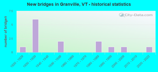
- New bridges - historical statistics
- 11920-1929
- 61930-1939
- 21950-1959
- 21980-1989
- 11990-1999
- 12000-2009
- 12020-2022

- Reconstructed bridges - Historical Statistics
- 41950-1959
- 21960-1969


- Bridge Condition - Deck
- 25.0%Very good
- 25.0%Good
- 33.3%Satisfactory
- 16.7%Fair

- Bridge Condition - Superstructure
- 41.7%Very good
- 8.3%Good
- 33.3%Satisfactory
- 16.7%Fair

- Bridge Condition - Substructure
- 25.0%Very good
- 25.0%Good
- 33.3%Satisfactory
- 16.7%Fair

- Bridge Condition - Channel
- 50.0%Very good
- 7.1%Good
- 35.7%Satisfactory
- 7.1%Fair

- Bridge Condition - Culverts
- 50.0%Very good
- 50.0%Good
Find on map >> Show street view
Structure Number: 100107000601071, Location: 1.5 MI JCT TH13 + VT100 (Lat: 43.995617, Lng: -72.832547), Route carried "on" structure: Other road C3002, Year Built: 2020, Status: Open, Structure Length: 0.73m (2.40ft), Average Daily Traffic: 100 (year 2020), Truck Traffic: 5%, Average Future Daily Traffic: 150 (year 2036), Design Load: HL 93, Features Intersected: KENDALL BROOK
Minimum Vertical Clearance: 30+ m (98+ ft), Kilometerpoint: 0.000, Lanes on structure: 2, Owner: Town or Township Highway Agency, Approaching Roadway Width: 6.4m (21.0ft), Skew: 3 degrees, Material/Design: Concrete, Design/Construction: Culvert, Number Of Spans In Main Unit: 1, Length of Maximum Span: 6.7m (22.0ft)
Condition: Channel: Very good, Culverts: Very good, Operating Rating: 42.6 metric tons, Method Used To Determine Operating Rating: Load and Resistance Factor (LRFR), Inventory Rating: 32.7 metric tons, Method Used To Determine Inventory Rating: Load and Resistance Factor (LRFR), Structural Evaluation: Equal to present desirable criteria, Waterway Adequacy: Better than present minimum criteria, Approach Roadway Alignment: Equal to present minimum criteria, Designated Inspection Frequency: Every 24 months, Inspection Date: October 2021
Find on map >> Show street view
Structure Number: 100107001401071, Location: 0.05 MI JCT 2 + VT100 (Lat: 43.985322, Lng: -72.846653), Route carried "on" structure: Other road C3002, Year Built: 1995, Status: Open, Structure Length: 0.85m (2.79ft), Average Daily Traffic: 296 (year 2019), Truck Traffic: 2%, Average Future Daily Traffic: 311 (year 2029), Design Load: HS 25 or greater, Features Intersected: ALDER MEADOW BROOK
Minimum Vertical Clearance: 30+ m (98+ ft), Kilometerpoint: 0.000, Lanes on structure: 2, Owner: Town or Township Highway Agency, Approaching Roadway Width: 7.3m (24.0ft), Material/Design: Concrete, Design/Construction: Slab, Number Of Spans In Main Unit: 1, Length of Maximum Span: 7.9m (25.9ft), Curb or Sidewalk Widths: Left: 0.2m (0.7ft), Right: 0.2m (0.7ft), Curb-To-Curb Width: 7.1m (23.3ft), Out-to-Out Width: 7.8m (25.6ft)
Condition: Deck: Very good, Superstructure: Very good, Substructure: Very good, Channel: Very good, Operating Rating: 75.3 metric tons, Method Used To Determine Operating Rating: Allowable Stress (AS), Inventory Rating: 44.5 metric tons, Method Used To Determine Inventory Rating: Allowable Stress (AS), Structural Evaluation: Equal to present desirable criteria, Deck Geometry: Meets minimum limits, Waterway Adequacy: Better than present minimum criteria, Approach Roadway Alignment: Equal to present desirable criteria, Designated Inspection Frequency: Every 24 months, Inspection Date: October 2021, Deck Structure Type: Concrete Cast-file-Place, Wearing Surface/Protective System: Wearing Surface: Bituminous, Membrane: Preformed Fabric, Deck Protection: Epoxy Coated Reinforcing
Find on map >> Show street view
Structure Number: 100107001501071, Location: AT JCT TH 23 + VT 12A (Lat: 44.013622, Lng: -72.755450), Route carried "on" structure: Other road C3023, Year Built: 2007, Status: Open, Structure Length: 1.13m (3.71ft), Average Daily Traffic: 40 (year 2019), Truck Traffic: 1%, Average Future Daily Traffic: 42 (year 2029), Design Load: HS 25 or greater, Features Intersected: THIRD BRANCH WHITE R
Minimum Vertical Clearance: 30+ m (98+ ft), Kilometerpoint: 0.000, Lanes on structure: 2, Owner: Town or Township Highway Agency, Approaching Roadway Width: 5.2m (17.1ft), Skew: 1 degrees, Material/Design: Concrete, Design/Construction: Slab, Number Of Spans In Main Unit: 1, Length of Maximum Span: 10.7m (35.1ft), Curb-To-Curb Width: 5.4m (17.7ft), Out-to-Out Width: 5.8m (19.0ft)
Condition: Deck: Very good, Superstructure: Very good, Substructure: Very good, Channel: Good, Operating Rating: 70.8 metric tons, Method Used To Determine Operating Rating: Load Factor (LF), Inventory Rating: 41.7 metric tons, Method Used To Determine Inventory Rating: Load Factor (LF), Structural Evaluation: Equal to present desirable criteria, Deck Geometry: High priority of corrective action, Waterway Adequacy: Equal to present minimum criteria, Approach Roadway Alignment: Equal to present desirable criteria, Designated Inspection Frequency: Every 24 months, Inspection Date: October 2021, Deck Structure Type: Concrete Cast-file-Place
Find on map >> Show street view
Structure Number: 100107001701071, Location: 0.1 MI JCT TH 4 & TH 14 (Lat: 43.995456, Lng: -72.877406), Route carried "on" structure: Other road C3004, Year Built: 1950, Status: Open, Structure Length: 1.13m (3.71ft), Average Daily Traffic: 20 (year 2019), Truck Traffic: 2%, Average Future Daily Traffic: 21 (year 2029), Features Intersected: CLARK BROOK
Minimum Vertical Clearance: 30+ m (98+ ft), Kilometerpoint: 0.000, Lanes on structure: 2, Owner: Town or Township Highway Agency, Approaching Roadway Width: 4.6m (15.1ft), Material/Design: Steel, Design/Construction: Culvert, Number Of Spans In Main Unit: 2, Length of Maximum Span: 5.5m (18.0ft)
Condition: Channel: Very good, Culverts: Good, Operating Rating: 28.1 metric tons, Method Used To Determine Operating Rating: Field evaluation and documented engineering judgment, Inventory Rating: 16.3 metric tons, Method Used To Determine Inventory Rating: Field evaluation and documented engineering judgment, Structural Evaluation: Somewhat better than minimum adequacy, Waterway Adequacy: Better than present minimum criteria, Approach Roadway Alignment: Meets minimum limits, Length Of Structure Improvement: 1.13m (3.71ft), Designated Inspection Frequency: Every 24 months, Inspection Date: October 2021, Bridge Improvement Cost: $194,000, Roadway Improvement Cost: $50,000, Total Project Cost: $244,000 ( Estimate for 2020)
Find on map >> Show street view
Structure Number: 100107002501071, Location: @ JCT W VT 100 & CL3 TH4 (Lat: 43.985058, Lng: -72.848236), Route carried "on" structure: Other road C3026, Year Built: 1985, Status: Open, Structure Length: 1.83m (6.00ft), Average Daily Traffic: 125 (year 2019), Truck Traffic: 25%, Average Future Daily Traffic: 132 (year 2029), Design Load: HS 20, Features Intersected: WHITE RIVER
Minimum Vertical Clearance: 30+ m (98+ ft), Kilometerpoint: 0.000, Lanes on structure: 2, Owner: Town or Township Highway Agency, Approaching Roadway Width: 7.3m (24.0ft), Material/Design: Steel, Design/Construction: Stringer/Multi-beam, Number Of Spans In Main Unit: 1, Length of Maximum Span: 17.7m (58.1ft), Curb or Sidewalk Widths: Left: 0.2m (0.7ft), Right: 0.2m (0.7ft), Curb-To-Curb Width: 6.9m (22.6ft), Out-to-Out Width: 7.7m (25.3ft)
Condition: Deck: Good, Superstructure: Very good, Substructure: Very good, Channel: Very good, Operating Rating: 53.5 metric tons, Method Used To Determine Operating Rating: Allowable Stress (AS), Inventory Rating: 38.1 metric tons, Method Used To Determine Inventory Rating: Allowable Stress (AS), Structural Evaluation: Equal to present desirable criteria, Deck Geometry: Meets minimum limits, Waterway Adequacy: Better than present minimum criteria, Approach Roadway Alignment: Equal to present desirable criteria, Designated Inspection Frequency: Every 24 months, Inspection Date: October 2021, Deck Structure Type: Concrete Cast-file-Place, Wearing Surface/Protective System: Deck Protection: Epoxy Coated Reinforcing
Find on map >> Show street view
Structure Number: 200013014701072, Location: 1.7 MI N JCT. VT.125 (Lat: 43.950747, Lng: -72.839856), Route carried "on" structure: State highway 100, Year Built: 1984, Status: Open, Structure Length: 2.38m (7.81ft), Average Daily Traffic: 1,200 (year 2018), Truck Traffic: 9%, Average Future Daily Traffic: 1,260 (year 2028), Design Load: HS 20+Mod, Features Intersected: WHITE RIVER
Minimum Vertical Clearance: 30+ m (98+ ft), Kilometerpoint: 179.556, Lanes on structure: 2, Base Highway Network: Yes, Owner: State Highway Agency, Approaching Roadway Width: 12.2m (40.0ft), Skew: 2 degrees, Material/Design: Steel, Design/Construction: Stringer/Multi-beam, Number Of Spans In Main Unit: 1, Length of Maximum Span: 23.2m (76.1ft), Curb or Sidewalk Widths: Left: 0.2m (0.7ft), Right: 0.2m (0.7ft), Curb-To-Curb Width: 11.8m (38.7ft), Out-to-Out Width: 12.5m (41.0ft)
Condition: Deck: Very good, Superstructure: Very good, Substructure: Good, Channel: Very good, Operating Rating: 79.8 metric tons, Method Used To Determine Operating Rating: Allowable Stress (AS), Inventory Rating: 45.4 metric tons, Method Used To Determine Inventory Rating: Allowable Stress (AS), Structural Evaluation: Better than present minimum criteria, Deck Geometry: Equal to present minimum criteria, Waterway Adequacy: Equal to present desirable criteria, Approach Roadway Alignment: Equal to present desirable criteria, Designated Inspection Frequency: Every 24 months, Inspection Date: July 2021, Deck Structure Type: Concrete Cast-file-Place, Wearing Surface/Protective System: Wearing Surface: Bituminous, Membrane: Preformed Fabric, Deck Protection: Epoxy Coated Reinforcing
Find on map >> Show street view
Structure Number: 200013014801072, Location: 2.3 MI N JCT. VT.125 (Lat: 43.958350, Lng: -72.840392), Route carried "on" structure: State highway 100, Year Built: 1953, Status: Open, Structure Length: 1.65m (5.41ft), Average Daily Traffic: 1,200 (year 2018), Truck Traffic: 9%, Average Future Daily Traffic: 1,260 (year 2028), Design Load: H 20, Features Intersected: WHITE RIVER
Minimum Vertical Clearance: 30+ m (98+ ft), Kilometerpoint: 180.409, Lanes on structure: 2, Base Highway Network: Yes, Owner: State Highway Agency, Approaching Roadway Width: 7.6m (24.9ft), Skew: 1 degrees, Material/Design: Concrete, Design/Construction: Tee Beam, Number Of Spans In Main Unit: 1, Length of Maximum Span: 15.2m (49.9ft), Curb or Sidewalk Widths: Left: 0.4m (1.3ft), Right: 0.4m (1.3ft), Curb-To-Curb Width: 9.4m (30.8ft), Out-to-Out Width: 10.4m (34.1ft)
Condition: Deck: Good, Superstructure: Good, Substructure: Good, Channel: Satisfactory, Operating Rating: 50.8 metric tons, Method Used To Determine Operating Rating: Allowable Stress (AS), Inventory Rating: 25.4 metric tons, Method Used To Determine Inventory Rating: Allowable Stress (AS), Structural Evaluation: Equal to present minimum criteria, Deck Geometry: Somewhat better than minimum adequacy, Waterway Adequacy: Somewhat better than minimum adequacy, Approach Roadway Alignment: Equal to present desirable criteria, Designated Inspection Frequency: Every 24 months, Inspection Date: July 2021, Deck Structure Type: Concrete Cast-file-Place, Wearing Surface/Protective System: Wearing Surface: Bituminous
Find on map >> Show street view
Structure Number: 200013015201072, Location: 3.4 MI N JCT. VT.125 (Lat: 43.974067, Lng: -72.842661), Route carried "on" structure: State highway 100, Year Built: 1936, Year Reconstructed: 1972, Status: Open, Structure Length: 1.95m (6.40ft), Average Daily Traffic: 1,100 (year 2018), Truck Traffic: 9%, Average Future Daily Traffic: 1,155 (year 2028), Design Load: H 15, Features Intersected: WHITE RIVER
Minimum Vertical Clearance: 30+ m (98+ ft), Kilometerpoint: 182.195, Lanes on structure: 2, Base Highway Network: Yes, Owner: State Highway Agency, Approaching Roadway Width: 7.3m (24.0ft), Skew: 4 degrees, Material/Design: Steel, Design/Construction: Stringer/Multi-beam, Number Of Spans In Main Unit: 1, Length of Maximum Span: 18.6m (61.0ft), Curb-To-Curb Width: 9.2m (30.2ft), Out-to-Out Width: 9.6m (31.5ft)
Condition: Deck: Satisfactory, Superstructure: Satisfactory, Substructure: Satisfactory, Channel: Satisfactory, Operating Rating: 37.2 metric tons, Method Used To Determine Operating Rating: Load Factor (LF), Inventory Rating: 22.7 metric tons, Method Used To Determine Inventory Rating: Load Factor (LF), Structural Evaluation: Equal to present minimum criteria, Deck Geometry: Somewhat better than minimum adequacy, Waterway Adequacy: High priority of corrective action, Approach Roadway Alignment: Equal to present desirable criteria, Length Of Structure Improvement: 1.95m (6.40ft), Designated Inspection Frequency: Every 24 months, Inspection Date: July 2021, Bridge Improvement Cost: $703,000, Roadway Improvement Cost: $50,000, Total Project Cost: $753,000 ( Estimate for 2020), Deck Structure Type: Concrete Cast-file-Place, Wearing Surface/Protective System: Wearing Surface: Bituminous
Find on map >> Show street view
Structure Number: 200013015301072, Location: 4.0 MI N JCT. VT.125 (Lat: 43.983356, Lng: -72.843747), Route carried "on" structure: State highway 100, Year Built: 1936, Year Reconstructed: 1972, Status: Open, Structure Length: 1.95m (6.40ft), Average Daily Traffic: 1,100 (year 2018), Truck Traffic: 9%, Average Future Daily Traffic: 1,155 (year 2028), Design Load: H 15, Features Intersected: ALDER MEADOW BROOK
Minimum Vertical Clearance: 30+ m (98+ ft), Kilometerpoint: 183.273, Lanes on structure: 2, Base Highway Network: Yes, Owner: State Highway Agency, Approaching Roadway Width: 7.9m (25.9ft), Skew: 3 degrees, Material/Design: Steel, Design/Construction: Stringer/Multi-beam, Number Of Spans In Main Unit: 1, Length of Maximum Span: 18.9m (62.0ft), Curb-To-Curb Width: 9.2m (30.2ft), Out-to-Out Width: 9.6m (31.5ft)
Condition: Deck: Good, Superstructure: Very good, Substructure: Good, Channel: Very good, Operating Rating: 47.2 metric tons, Method Used To Determine Operating Rating: Load Factor (LF), Inventory Rating: 28.1 metric tons, Method Used To Determine Inventory Rating: Load Factor (LF), Structural Evaluation: Better than present minimum criteria, Deck Geometry: Somewhat better than minimum adequacy, Waterway Adequacy: Equal to present minimum criteria, Approach Roadway Alignment: Equal to present minimum criteria, Designated Inspection Frequency: Every 24 months, Inspection Date: July 2021, Deck Structure Type: Concrete Cast-file-Place, Wearing Surface/Protective System: Wearing Surface: Bituminous, Membrane: Preformed Fabric
Find on map >> Show street view
Structure Number: 200013015401072, Location: 5.3 MI N JCT. VT.125 (Lat: 43.998547, Lng: -72.852431), Route carried "on" structure: State highway 100, Year Built: 1932, Year Reconstructed: 1959, Status: Open, Structure Length: 0.73m (2.40ft), Average Daily Traffic: 1,200 (year 2018), Truck Traffic: 9%, Average Future Daily Traffic: 1,260 (year 2028), Design Load: H 15, Features Intersected: ALDER MEADOW BROOK
Minimum Vertical Clearance: 30+ m (98+ ft), Kilometerpoint: 185.252, Lanes on structure: 2, Base Highway Network: Yes, Owner: State Highway Agency, Approaching Roadway Width: 9.1m (29.9ft), Skew: 3 degrees, Material/Design: Concrete, Design/Construction: Slab, Number Of Spans In Main Unit: 1, Length of Maximum Span: 6.1m (20.0ft), Curb or Sidewalk Widths: Left: 0.4m (1.3ft), Right: 0.4m (1.3ft), Curb-To-Curb Width: 9.4m (30.8ft), Out-to-Out Width: 11.0m (36.1ft)
Condition: Deck: Fair, Superstructure: Fair, Substructure: Fair, Channel: Fair, Operating Rating: 41.7 metric tons, Method Used To Determine Operating Rating: Load Factor (LF), Inventory Rating: 24.5 metric tons, Method Used To Determine Inventory Rating: Load Factor (LF), Structural Evaluation: Somewhat better than minimum adequacy, Deck Geometry: Somewhat better than minimum adequacy, Waterway Adequacy: Meets minimum limits, Approach Roadway Alignment: Equal to present desirable criteria, Length Of Structure Improvement: 0.73m (2.40ft), Designated Inspection Frequency: Every 24 months, Inspection Date: July 2021, Bridge Improvement Cost: $302,000, Roadway Improvement Cost: $50,000, Total Project Cost: $352,000 ( Estimate for 2020), Deck Structure Type: Concrete Cast-file-Place, Wearing Surface/Protective System: Wearing Surface: Bituminous
Find on map >> Show street view
Structure Number: 200013015501072, Location: 5.7 MI N JCT. VT.125 (Lat: 44.003478, Lng: -72.850547), Route carried "on" structure: State highway 100, Year Built: 1933, Year Reconstructed: 1959, Status: Open, Structure Length: 1.01m (3.31ft), Average Daily Traffic: 1,200 (year 2018), Truck Traffic: 9%, Average Future Daily Traffic: 1,260 (year 2028), Design Load: H 15, Features Intersected: ALDER MEADOW BROOK
Minimum Vertical Clearance: 30+ m (98+ ft), Kilometerpoint: 185.992, Lanes on structure: 2, Base Highway Network: Yes, Owner: State Highway Agency, Approaching Roadway Width: 9.1m (29.9ft), Skew: 4 degrees, Material/Design: Concrete, Design/Construction: Tee Beam, Number Of Spans In Main Unit: 1, Length of Maximum Span: 8.5m (27.9ft), Curb or Sidewalk Widths: Left: 0.4m (1.3ft), Right: 0.4m (1.3ft), Curb-To-Curb Width: 9.4m (30.8ft), Out-to-Out Width: 10.8m (35.4ft)
Condition: Deck: Satisfactory, Superstructure: Satisfactory, Substructure: Satisfactory, Channel: Satisfactory, Operating Rating: 60.8 metric tons, Method Used To Determine Operating Rating: Load Factor (LF), Inventory Rating: 36.3 metric tons, Method Used To Determine Inventory Rating: Load Factor (LF), Structural Evaluation: Equal to present minimum criteria, Deck Geometry: Somewhat better than minimum adequacy, Waterway Adequacy: Meets minimum limits, Approach Roadway Alignment: Somewhat better than minimum adequacy, Designated Inspection Frequency: Every 24 months, Inspection Date: July 2021, Deck Structure Type: Concrete Cast-file-Place, Wearing Surface/Protective System: Wearing Surface: Bituminous
Find on map >> Show street view
Structure Number: 200013015901072, Location: 6.7 MI N JCT. VT.125 (Lat: 44.017022, Lng: -72.850439), Route carried "on" structure: State highway 100, Year Built: 1933, Year Reconstructed: 1959, Status: Open, Structure Length: 0.70m (2.30ft), Average Daily Traffic: 1,200 (year 2018), Truck Traffic: 9%, Average Future Daily Traffic: 1,260 (year 2028), Design Load: H 15, Features Intersected: ALDER MEADOW BROOK
Minimum Vertical Clearance: 30+ m (98+ ft), Kilometerpoint: 187.714, Lanes on structure: 2, Base Highway Network: Yes, Owner: State Highway Agency, Approaching Roadway Width: 9.1m (29.9ft), Skew: 3 degrees, Material/Design: Concrete, Design/Construction: Slab, Number Of Spans In Main Unit: 1, Length of Maximum Span: 6.1m (20.0ft), Curb or Sidewalk Widths: Left: 0.4m (1.3ft), Right: 0.4m (1.3ft), Curb-To-Curb Width: 9.2m (30.2ft), Out-to-Out Width: 10.7m (35.1ft)
Condition: Deck: Satisfactory, Superstructure: Satisfactory, Substructure: Satisfactory, Channel: Satisfactory, Operating Rating: 52.6 metric tons, Method Used To Determine Operating Rating: Load Factor (LF), Inventory Rating: 30.8 metric tons, Method Used To Determine Inventory Rating: Load Factor (LF), Structural Evaluation: Equal to present minimum criteria, Deck Geometry: Somewhat better than minimum adequacy, Waterway Adequacy: Meets minimum limits, Approach Roadway Alignment: Equal to present desirable criteria, Designated Inspection Frequency: Every 24 months, Inspection Date: July 2021, Deck Structure Type: Concrete Cast-file-Place, Wearing Surface/Protective System: Wearing Surface: Bituminous
Find on map >> Show street view
Structure Number: 200013016001072, Location: 6.9 MI N JCT. VT.125 (Lat: 44.019292, Lng: -72.848025), Route carried "on" structure: State highway 100, Year Built: 1933, Year Reconstructed: 1959, Status: Open, Structure Length: 0.70m (2.30ft), Average Daily Traffic: 1,200 (year 2018), Truck Traffic: 9%, Average Future Daily Traffic: 1,260 (year 2028), Design Load: H 15, Features Intersected: ALDER MEADOW BROOK
Minimum Vertical Clearance: 30+ m (98+ ft), Kilometerpoint: 188.052, Lanes on structure: 2, Base Highway Network: Yes, Owner: State Highway Agency, Approaching Roadway Width: 9.8m (32.2ft), Skew: 3 degrees, Material/Design: Concrete, Design/Construction: Slab, Number Of Spans In Main Unit: 1, Length of Maximum Span: 6.1m (20.0ft), Curb or Sidewalk Widths: Left: 0.4m (1.3ft), Right: 0.4m (1.3ft), Curb-To-Curb Width: 9.5m (31.2ft), Out-to-Out Width: 10.9m (35.8ft)
Condition: Deck: Satisfactory, Superstructure: Satisfactory, Substructure: Satisfactory, Channel: Very good, Operating Rating: 39.0 metric tons, Method Used To Determine Operating Rating: Load Factor (LF), Inventory Rating: 23.6 metric tons, Method Used To Determine Inventory Rating: Load Factor (LF), Structural Evaluation: Equal to present minimum criteria, Deck Geometry: Somewhat better than minimum adequacy, Waterway Adequacy: Meets minimum limits, Approach Roadway Alignment: Equal to present desirable criteria, Designated Inspection Frequency: Every 24 months, Inspection Date: July 2021, Deck Structure Type: Concrete Cast-file-Place, Wearing Surface/Protective System: Wearing Surface: Bituminous
Find on map >> Show street view
Structure Number: 200187001201072, Location: 8.9 MI N JCT. VT.12 S (Lat: 44.016514, Lng: -72.758689), Route carried "on" structure: Alternate State highway 12A, Year Built: 1929, Status: Open, Structure Length: 0.73m (2.40ft), Average Daily Traffic: 400 (year 2018), Truck Traffic: 6%, Average Future Daily Traffic: 420 (year 2028), Design Load: H 15, Features Intersected: E. GRANVILLE BROOK
Minimum Vertical Clearance: 30+ m (98+ ft), Kilometerpoint: 0.000, Lanes on structure: 2, Owner: State Highway Agency, Approaching Roadway Width: 8.5m (27.9ft), Skew: 1 degrees, Material/Design: Concrete, Design/Construction: Slab, Number Of Spans In Main Unit: 1, Length of Maximum Span: 6.1m (20.0ft), Curb or Sidewalk Widths: Left: 0.2m (0.7ft), Right: 0.2m (0.7ft), Curb-To-Curb Width: 8.9m (29.2ft), Out-to-Out Width: 9.9m (32.5ft)
Condition: Deck: Fair, Superstructure: Fair, Substructure: Fair, Channel: Satisfactory, Operating Rating: 40.8 metric tons, Method Used To Determine Operating Rating: Load Factor (LF), Inventory Rating: 24.5 metric tons, Method Used To Determine Inventory Rating: Load Factor (LF), Structural Evaluation: Somewhat better than minimum adequacy, Deck Geometry: Equal to present minimum criteria, Waterway Adequacy: Equal to present minimum criteria, Approach Roadway Alignment: Equal to present desirable criteria, Length Of Structure Improvement: 0.73m (2.40ft), Designated Inspection Frequency: Every 24 months, Inspection Date: June 2021, Bridge Improvement Cost: $273,000, Roadway Improvement Cost: $50,000, Total Project Cost: $323,000 ( Estimate for 2020), Deck Structure Type: Concrete Cast-file-Place, Wearing Surface/Protective System: Wearing Surface: Bituminous