Bridge Statistics for Gratiot, Ohio (OH)
Condition, Traffic, Stress, Structural Evaluation, Project Costs
- National Bridge Inventory (NBI) Statistics
- 18Number of bridges
- 125ft / 37.8mTotal length
- 114,663Total average daily traffic
- 23,114Total average daily truck traffic
- National Bridge Inventory (NBI) Registered Bridges for Gratiot
- No street view available for this location
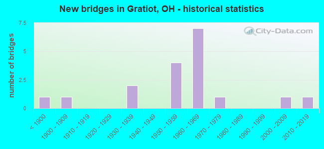
- New bridges - historical statistics
- 1Before 1900
- 11900-1909
- 21930-1939
- 41950-1959
- 71960-1969
- 11970-1979
- 12000-2009
- 12010-2019

- Reconstructed bridges - Historical Statistics
- 21990-1999
- 02000-2009
- 32010-2019


- Bridge Condition - Deck
- 16.7%Excellent
- 41.7%Very good
- 25.0%Good
- 8.3%Satisfactory
- 8.3%Fair

- Bridge Condition - Superstructure
- 21.4%Excellent
- 35.7%Very good
- 21.4%Good
- 14.3%Satisfactory
- 7.1%Serious

- Bridge Condition - Substructure
- 14.3%Excellent
- 21.4%Very good
- 42.9%Good
- 21.4%Fair

- Bridge Condition - Channel
- 41.7%Very good
- 50.0%Good
- 8.3%Fair
Find on map >> Show street view
Structure Number: 4530144, Location: 0.28 Mi W of CR 339 (Lat: 39.965961, Lng: -82.231600), Route carried "on" structure: County highway T0338, Year Built: 1969, Year Reconstructed: 2010, Status: Open, Structure Length: 0.98m (3.22ft), Average Daily Traffic: 96 (year 2015), Truck Traffic: 7%, Average Future Daily Traffic: 133 (year 2035), Design Load: HS 20, Features Intersected: Valley Run, Facility Carried by Structure: Cramer Rd
Minimum Vertical Clearance: 30+ m (98+ ft), Kilometerpoint: 1.931, Lanes on structure: 2, Owner: County Highway Agency, Approaching Roadway Width: 4.9m (16.1ft), Skew: 2 degrees, Material/Design: Steel, Design/Construction: Stringer/Multi-beam, Number Of Spans In Main Unit: 1, Length of Maximum Span: 9.4m (30.8ft), Curb-To-Curb Width: 5.9m (19.4ft), Out-to-Out Width: 5.9m (19.4ft)
Condition: Deck: Satisfactory, Superstructure: Satisfactory, Substructure: Fair, Channel: Fair, Operating Rating: 87.5 metric tons, Method Used To Determine Operating Rating: Load Factor (LF) rating reported by rating factor (RF) method using MS18 loading, Inventory Rating: 61.6 metric tons, Method Used To Determine Inventory Rating: Load Factor (LF) rating reported by rating factor (RF) method using MS18 loading, Structural Evaluation: Somewhat better than minimum adequacy, Deck Geometry: Meets minimum limits, Waterway Adequacy: Meets minimum limits, Approach Roadway Alignment: Meets minimum limits, Designated Inspection Frequency: Every 12 months, Inspection Date: March 2021, Deck Structure Type: Wood or Timber, Wearing Surface/Protective System: Wearing Surface: Wood or Timber
Find on map >> Show street view
Structure Number: 4530161, Location: 0.8 Mi S of Cramer Rd (Lat: 39.954569, Lng: -82.224389), Route carried "on" structure: County highway C0339, Year Built: 2015, Status: Open, Structure Length: 0.73m (2.40ft), Average Daily Traffic: 385 (year 2018), Truck Traffic: 8%, Average Future Daily Traffic: 534 (year 2038), Design Load: HL 93, Features Intersected: Trib of Valley Run, Facility Carried by Structure: Poplar Forks Rd
Minimum Vertical Clearance: 30+ m (98+ ft), Kilometerpoint: 0.563, Lanes on structure: 2, Owner: County Highway Agency, Approaching Roadway Width: 5.8m (19.0ft), Skew: 2 degrees, Material/Design: Concrete, Design/Construction: Culvert, Number Of Spans In Main Unit: 1, Length of Maximum Span: 6.7m (22.0ft)
Condition: Channel: Good, Culverts: Excellent, Operating Rating: 45.4 metric tons, Method Used To Determine Operating Rating: Load and Resistance Factor Rating (LRFR) rating reported by rating factor(RF) method using HL-93 loadings, Inventory Rating: 35.6 metric tons, Method Used To Determine Inventory Rating: Load and Resistance Factor Rating (LRFR) rating reported by rating factor(RF) method using HL-93 loadings, Structural Evaluation: Superior to present desirable criteria, Waterway Adequacy: Somewhat better than minimum adequacy, Approach Roadway Alignment: Equal to present desirable criteria, Designated Inspection Frequency: Every 24 months, Inspection Date: June 2021
Find on map >> Show street view
Structure Number: 6000991, Location: .26 M E OF LIC CO LINE (Lat: 39.948111, Lng: -82.226961), Route carried "on" structure: US 40, Year Built: 1939, Year Reconstructed: 2001, Status: Open, Structure Length: 1.18m (3.87ft), Average Daily Traffic: 4,149 (year 2015), Truck Traffic: 4%, Average Future Daily Traffic: 5,759 (year 2035), Design Load: HS 20+Mod, Features Intersected: OVER VALLEY RUN
Minimum Vertical Clearance: 30+ m (98+ ft), Kilometerpoint: 0.418, Lanes on structure: 4, Owner: State Highway Agency, Approaching Roadway Width: 19.5m (64.0ft), Material/Design: Prestressed concrete, Design/Construction: Box Beam or Girders - Multiple, Number Of Spans In Main Unit: 1, Length of Maximum Span: 11.4m (37.4ft), Curb-To-Curb Width: 19.5m (64.0ft), Out-to-Out Width: 19.5m (64.0ft)
Condition: Deck: Very good, Superstructure: Very good, Substructure: Good, Channel: Good, Operating Rating: 84.2 metric tons, Method Used To Determine Operating Rating: Load Factor (LF) rating reported by rating factor (RF) method using MS18 loading, Inventory Rating: 48.6 metric tons, Method Used To Determine Inventory Rating: Load Factor (LF) rating reported by rating factor (RF) method using MS18 loading, Structural Evaluation: Better than present minimum criteria, Deck Geometry: Better than present minimum criteria, Waterway Adequacy: Better than present minimum criteria, Approach Roadway Alignment: Equal to present minimum criteria, Designated Inspection Frequency: Every 24 months, Inspection Date: October 2021, Deck Structure Type: Concrete Cast-file-Place, Wearing Surface/Protective System: Wearing Surface: Monolithic Concrete
Find on map >> Show street view
Structure Number: 6001025, Location: 1.2 M E OF LIC CO LINE (Lat: 39.955639, Lng: -82.196639), Route carried "on" structure: US 40, Year Built: 1939, Year Reconstructed: 2010, Status: Open, Structure Length: 1.46m (4.79ft), Average Daily Traffic: 4,426 (year 2015), Truck Traffic: 4%, Average Future Daily Traffic: 6,143 (year 2035), Design Load: HS 20, Features Intersected: OVER KENT RUN
Minimum Vertical Clearance: 30+ m (98+ ft), Kilometerpoint: 1.915, Lanes on structure: 4, Owner: State Highway Agency, Approaching Roadway Width: 20.1m (65.9ft), Skew: 1 degrees, Material/Design: Prestressed concrete, Design/Construction: Box Beam or Girders - Multiple, Number Of Spans In Main Unit: 1, Length of Maximum Span: 14.3m (46.9ft), Curb-To-Curb Width: 20.1m (65.9ft), Out-to-Out Width: 20.1m (65.9ft)
Condition: Deck: Excellent, Superstructure: Excellent, Substructure: Very good, Channel: Good, Operating Rating: 42.1 metric tons, Method Used To Determine Operating Rating: Load Factor (LF) rating reported by rating factor (RF) method using MS18 loading, Inventory Rating: 32.4 metric tons, Method Used To Determine Inventory Rating: Load Factor (LF) rating reported by rating factor (RF) method using MS18 loading, Structural Evaluation: Equal to present desirable criteria, Deck Geometry: Better than present minimum criteria, Waterway Adequacy: Better than present minimum criteria, Approach Roadway Alignment: Better than present minimum criteria, Designated Inspection Frequency: Every 24 months, Inspection Date: October 2021, Deck Structure Type: Concrete Cast-file-Place, Wearing Surface/Protective System: Wearing Surface: Monolithic Concrete, Deck Protection: Epoxy Coated Reinforcing
Find on map >> Show street view
Structure Number: 6002285, Location: .6 MI E OF LIC CO LINE (Lat: 39.946181, Lng: -82.222350), Route carried "on" structure: County highway C0030, Year Built: 1959, Year Reconstructed: 2018, Status: Open, Structure Length: 7.23m (23.72ft), Average Daily Traffic: 2,783 (year 2015), Truck Traffic: 7%, Average Future Daily Traffic: 46,259 (year 2035), Design Load: HS 20+Mod, Features Intersected: CR30 MT PERRY OVER I70, Facility Carried by Structure: CR 30
Minimum Vertical Clearance: 30+ m (98+ ft), Kilometerpoint: 0.950, Lanes on structure: 2, Lanes under structure: 4, Owner: State Highway Agency, Approaching Roadway Width: 9.1m (29.9ft), Skew: 2 degrees, Material/Design: Steel continuous, Design/Construction: Stringer/Multi-beam, Number Of Spans In Main Unit: 4, Length of Maximum Span: 22.7m (74.5ft), Curb-To-Curb Width: 8.6m (28.2ft), Out-to-Out Width: 9.6m (31.5ft)
Condition: Deck: Excellent, Superstructure: Excellent, Substructure: Excellent, Operating Rating: 84.2 metric tons, Method Used To Determine Operating Rating: Load Factor (LF) rating reported by rating factor (RF) method using MS18 loading, Inventory Rating: 48.6 metric tons, Method Used To Determine Inventory Rating: Load Factor (LF) rating reported by rating factor (RF) method using MS18 loading, Structural Evaluation: Superior to present desirable criteria, Deck Geometry: Meets minimum limits, Underclear: Equal to present minimum criteria, Approach Roadway Alignment: Equal to present desirable criteria, Designated Inspection Frequency: Every 24 months, Inspection Date: April 2021, Deck Structure Type: Concrete Cast-file-Place, Wearing Surface/Protective System: Wearing Surface: Monolithic Concrete, Deck Protection: Epoxy Coated Reinforcing
Find on map >> Show street view
Structure Number: 6002315, Location: 1.95 MI E OF LIC CO LINE (Lat: 39.953389, Lng: -82.189139), Route carried "on" structure: Interstate 70, Year Built: 1968, Status: Open, Structure Length: 6.04m (19.82ft), Average Daily Traffic: 16,664 (year 2015), Truck Traffic: 25%, Average Future Daily Traffic: 23,130 (year 2035), Design Load: HS 20+Mod, Features Intersected: IR 70 OVER KENT RUN
Minimum Vertical Clearance: 30+ m (98+ ft), Kilometerpoint: 3.187, Lanes on structure: 2, Base Highway Network: Yes (, Subroute: 1), Owner: State Highway Agency, Approaching Roadway Width: 14.9m (48.9ft), Skew: 2 degrees, Material/Design: Steel continuous, Design/Construction: Stringer/Multi-beam, Number Of Spans In Main Unit: 3, Length of Maximum Span: 22.9m (75.1ft), Curb-To-Curb Width: 12.2m (40.0ft), Out-to-Out Width: 13.2m (43.3ft)
Condition: Deck: Good, Superstructure: Good, Substructure: Good, Channel: Good, Operating Rating: 42.1 metric tons, Method Used To Determine Operating Rating: Allowable Stress (AS) rating reported by rating factor (RF) method using MS18 loading, Inventory Rating: 32.4 metric tons, Method Used To Determine Inventory Rating: Allowable Stress (AS) rating reported by rating factor (RF) method using MS18 loading, Structural Evaluation: Better than present minimum criteria, Deck Geometry: Better than present minimum criteria, Waterway Adequacy: Equal to present desirable criteria, Approach Roadway Alignment: Equal to present desirable criteria, Designated Inspection Frequency: Every 24 months, Inspection Date: April 2021, Deck Structure Type: Concrete Cast-file-Place, Wearing Surface/Protective System: Wearing Surface: Integral Concrete
Find on map >> Show street view
Structure Number: 6002374, Location: 1.95 MI E OF LIC CO LINE (Lat: 39.953089, Lng: -82.189081), Route carried "on" structure: Interstate 70, Year Built: 1968, Status: Open, Structure Length: 6.04m (19.82ft), Average Daily Traffic: 16,664 (year 2015), Truck Traffic: 25%, Average Future Daily Traffic: 23,130 (year 2035), Design Load: HS 20, Features Intersected: IR 70 OVER KENT RUN
Minimum Vertical Clearance: 30+ m (98+ ft), Kilometerpoint: 3.187, Lanes on structure: 2, Base Highway Network: Yes (, Subroute: 1), Owner: State Highway Agency, Approaching Roadway Width: 14.9m (48.9ft), Skew: 2 degrees, Material/Design: Steel continuous, Design/Construction: Stringer/Multi-beam, Number Of Spans In Main Unit: 3, Length of Maximum Span: 22.9m (75.1ft), Curb-To-Curb Width: 12.2m (40.0ft), Out-to-Out Width: 13.2m (43.3ft)
Condition: Deck: Good, Superstructure: Very good, Substructure: Good, Channel: Very good, Operating Rating: 38.9 metric tons, Method Used To Determine Operating Rating: Load and Resistance Factor Rating (LRFR) rating reported by rating factor(RF) method using HL-93 loadings, Inventory Rating: 32.4 metric tons, Method Used To Determine Inventory Rating: Load and Resistance Factor Rating (LRFR) rating reported by rating factor(RF) method using HL-93 loadings, Structural Evaluation: Better than present minimum criteria, Deck Geometry: Better than present minimum criteria, Waterway Adequacy: Equal to present desirable criteria, Approach Roadway Alignment: Equal to present desirable criteria, Designated Inspection Frequency: Every 24 months, Inspection Date: April 2021, Deck Structure Type: Concrete Cast-file-Place, Wearing Surface/Protective System: Wearing Surface: Integral Concrete
Find on map >> Show street view
Structure Number: 6002404, Location: 3 MI EAST OF LIC CO LINE (Lat: 39.950500, Lng: -82.170469), Route carried "on" structure: Interstate 70, Year Built: 1968, Status: Open, Structure Length: 4.24m (13.91ft), Average Daily Traffic: 16,664 (year 2015), Truck Traffic: 25%, Average Future Daily Traffic: 23,130 (year 2035), Design Load: HS 20+Mod, Features Intersected: IR 70 OVR CR28 HOPEWEL R
Minimum Vertical Clearance: 30+ m (98+ ft), Kilometerpoint: 4.812, Lanes on structure: 2, Lanes under structure: 2, Base Highway Network: Yes (, Subroute: 1), Owner: State Highway Agency, Approaching Roadway Width: 14.9m (48.9ft), Skew: 1 degrees, Material/Design: Steel continuous, Design/Construction: Stringer/Multi-beam, Number Of Spans In Main Unit: 3, Length of Maximum Span: 16.2m (53.1ft), Curb-To-Curb Width: 12.2m (40.0ft), Out-to-Out Width: 13.2m (43.3ft)
Condition: Deck: Very good, Superstructure: Very good, Substructure: Very good, Operating Rating: 42.1 metric tons, Method Used To Determine Operating Rating: Allowable Stress (AS) rating reported by rating factor (RF) method using MS18 loading, Inventory Rating: 32.4 metric tons, Method Used To Determine Inventory Rating: Allowable Stress (AS) rating reported by rating factor (RF) method using MS18 loading, Structural Evaluation: Equal to present desirable criteria, Deck Geometry: Better than present minimum criteria, Underclear: Superior to present desirable criteria, Approach Roadway Alignment: Equal to present desirable criteria, Designated Inspection Frequency: Every 24 months, Inspection Date: April 2021, Deck Structure Type: Concrete Cast-file-Place, Wearing Surface/Protective System: Wearing Surface: Integral Concrete
Find on map >> Show street view
Structure Number: 6002439, Location: 3 MI EAST OF LIC CO LINE (Lat: 39.950189, Lng: -82.170419), Route carried "on" structure: Interstate 70, Year Built: 1968, Status: Open, Structure Length: 3.66m (12.01ft), Average Daily Traffic: 16,664 (year 2015), Truck Traffic: 25%, Average Future Daily Traffic: 23,130 (year 2035), Design Load: HS 20+Mod, Features Intersected: IR 70 OVR CR28 HOPEWEL R
Minimum Vertical Clearance: 30+ m (98+ ft), Kilometerpoint: 4.812, Lanes on structure: 2, Lanes under structure: 2, Base Highway Network: Yes (, Subroute: 1), Owner: State Highway Agency, Approaching Roadway Width: 14.9m (48.9ft), Skew: 1 degrees, Material/Design: Steel continuous, Design/Construction: Stringer/Multi-beam, Number Of Spans In Main Unit: 3, Length of Maximum Span: 13.7m (44.9ft), Curb-To-Curb Width: 12.2m (40.0ft), Out-to-Out Width: 13.2m (43.3ft)
Condition: Deck: Very good, Superstructure: Very good, Substructure: Very good, Operating Rating: 42.1 metric tons, Method Used To Determine Operating Rating: Allowable Stress (AS) rating reported by rating factor (RF) method using MS18 loading, Inventory Rating: 32.4 metric tons, Method Used To Determine Inventory Rating: Allowable Stress (AS) rating reported by rating factor (RF) method using MS18 loading, Structural Evaluation: Equal to present desirable criteria, Deck Geometry: Better than present minimum criteria, Underclear: Somewhat better than minimum adequacy, Approach Roadway Alignment: Equal to present desirable criteria, Designated Inspection Frequency: Every 24 months, Inspection Date: April 2021, Deck Structure Type: Concrete Cast-file-Place, Wearing Surface/Protective System: Wearing Surface: Integral Concrete
Find on map >> Show street view
Structure Number: 6039154, Location: .19 MI W OF POPLAR FORKS (Lat: 39.949011, Lng: -82.227161), Route carried "on" structure: County highway T0026, Year Built: 1830, Status: Posted for load, Structure Length: 1.07m (3.51ft), Average Daily Traffic: 209 (year 2015), Truck Traffic: 7%, Average Future Daily Traffic: 290 (year 2035), Features Intersected: VALLEY RUN, Facility Carried by Structure: NORTH PIKE
Minimum Vertical Clearance: 30+ m (98+ ft), Kilometerpoint: 0.402, Lanes on structure: 2, Owner: County Highway Agency, Approaching Roadway Width: 6.7m (22.0ft), Material/Design: Masonry, Design/Construction: Arch - Deck, Number Of Spans In Main Unit: 1, Length of Maximum Span: 7.6m (24.9ft), Curb-To-Curb Width: 7.9m (25.9ft), Out-to-Out Width: 8.9m (29.2ft)
Condition: Superstructure: Serious, Substructure: Fair, Channel: Good, Operating Rating: 5.4 metric tons, Method Used To Determine Operating Rating: Field evaluation and documented engineering judgment, Inventory Rating: 3.6 metric tons, Method Used To Determine Inventory Rating: Field evaluation and documented engineering judgment, Structural Evaluation: High priority of corrective action, Deck Geometry: Somewhat better than minimum adequacy, Waterway Adequacy: Better than present minimum criteria, Approach Roadway Alignment: Superior to present desirable criteria, Bridge Posting: Required (Relationship of Operating Rating to Maximum Legal Load: > 39.9% below), Designated Inspection Frequency: Every 12 months, Inspection Date: October 2020, Wearing Surface/Protective System: Wearing Surface: Bituminous
Find on map >> Show street view
Structure Number: 6039324, Location: .97 MI N OF COUNTY LINE (Lat: 39.919789, Lng: -82.186919), Route carried "on" structure: County highway C0071, Year Built: 1952, Status: Open, Structure Length: 0.85m (2.79ft), Average Daily Traffic: 300 (year 2015), Truck Traffic: 7%, Average Future Daily Traffic: 416 (year 2035), Design Load: HS 20+Mod, Features Intersected: KENT RUN, Facility Carried by Structure: COOPERMILL ROAD
Minimum Vertical Clearance: 30+ m (98+ ft), Kilometerpoint: 1.561, Lanes on structure: 2, Owner: County Highway Agency, Approaching Roadway Width: 5.5m (18.0ft), Material/Design: Steel, Design/Construction: Stringer/Multi-beam, Number Of Spans In Main Unit: 1, Length of Maximum Span: 6.7m (22.0ft), Curb-To-Curb Width: 6.3m (20.7ft), Out-to-Out Width: 6.3m (20.7ft)
Condition: Deck: Fair, Superstructure: Satisfactory, Substructure: Fair, Channel: Very good, Operating Rating: 42.1 metric tons, Method Used To Determine Operating Rating: Load Factor (LF) rating reported by rating factor (RF) method using MS18 loading, Inventory Rating: 32.4 metric tons, Method Used To Determine Inventory Rating: Load Factor (LF) rating reported by rating factor (RF) method using MS18 loading, Structural Evaluation: Somewhat better than minimum adequacy, Deck Geometry: Meets minimum limits, Waterway Adequacy: Equal to present minimum criteria, Approach Roadway Alignment: Meets minimum limits, Designated Inspection Frequency: Every 12 months, Inspection Date: October 2020, Deck Structure Type: Concrete Cast-file-Place, Wearing Surface/Protective System: Wearing Surface: Bituminous
Find on map >> Show street view
Structure Number: 6039545, Location: 0.26 MI W OF S HOPEWELL R (Lat: 39.940331, Lng: -82.181411), Route carried "on" structure: County highway T0285, Year Built: 1976, Year Reconstructed: 2021, Status: Open, Structure Length: 1.26m (4.13ft), Average Daily Traffic: 324 (year 2015), Truck Traffic: 7%, Average Future Daily Traffic: 450 (year 2035), Design Load: HS 20, Features Intersected: KENT RUN, Facility Carried by Structure: PALMER ROAD
Minimum Vertical Clearance: 30+ m (98+ ft), Kilometerpoint: 5.810, Lanes on structure: 2, Owner: County Highway Agency, Approaching Roadway Width: 6.4m (21.0ft), Skew: 1 degrees, Material/Design: Steel, Design/Construction: Stringer/Multi-beam, Number Of Spans In Main Unit: 1, Length of Maximum Span: 11.7m (38.4ft), Curb-To-Curb Width: 6.2m (20.3ft), Out-to-Out Width: 6.2m (20.3ft)
Condition: Superstructure: Excellent, Substructure: Excellent, Channel: Very good, Operating Rating: 51.8 metric tons, Method Used To Determine Operating Rating: Load Factor (LF) rating reported by rating factor (RF) method using MS18 loading, Inventory Rating: 29.2 metric tons, Method Used To Determine Inventory Rating: Load Factor (LF) rating reported by rating factor (RF) method using MS18 loading, Structural Evaluation: Better than present minimum criteria, Deck Geometry: Meets minimum limits, Waterway Adequacy: Equal to present minimum criteria, Approach Roadway Alignment: Somewhat better than minimum adequacy, Designated Inspection Frequency: Every 12 months, Inspection Date: November 2021, Deck Structure Type: Concrete Cast-file-Place, Wearing Surface/Protective System: Wearing Surface: Monolithic Concrete, Deck Protection: Other
Find on map >> Show street view
Structure Number: 6039707, Location: 0.6 MI W OF S HOPEWELL RD (Lat: 39.930981, Lng: -82.187350), Route carried "on" structure: County highway T0412, Year Built: 1900, Status: Open, Structure Length: 0.85m (2.79ft), Average Daily Traffic: 209 (year 2015), Truck Traffic: 7%, Average Future Daily Traffic: 290 (year 2035), Features Intersected: KENT RUN, Facility Carried by Structure: ASBURY CHAPEL ROAD
Minimum Vertical Clearance: 30+ m (98+ ft), Kilometerpoint: 1.513, Lanes on structure: 1, Owner: County Highway Agency, Approaching Roadway Width: 4.3m (14.1ft), Material/Design: Concrete, Design/Construction: Slab, Number Of Spans In Main Unit: 1, Length of Maximum Span: 8.2m (26.9ft), Curb-To-Curb Width: 4.1m (13.5ft), Out-to-Out Width: 4.8m (15.7ft)
Condition: Deck: Good, Superstructure: Good, Substructure: Good, Channel: Good, Operating Rating: 40.8 metric tons, Method Used To Determine Operating Rating: Field evaluation and documented engineering judgment, Inventory Rating: 32.7 metric tons, Method Used To Determine Inventory Rating: Field evaluation and documented engineering judgment, Structural Evaluation: Better than present minimum criteria, Deck Geometry: High priority of replacement, Waterway Adequacy: Better than present minimum criteria, Approach Roadway Alignment: High priority of corrective action, Designated Inspection Frequency: Every 24 months, Inspection Date: October 2020, Deck Structure Type: Concrete Cast-file-Place, Wearing Surface/Protective System: Wearing Surface: Gravel
Find on map >> Show street view
Structure Number: 6432018, Location: 110 FT EAST OF CR 34 (Lat: 39.900650, Lng: -82.203400), Route carried "on" structure: County highway C0067, Year Built: 1958, Year Reconstructed: 2002, Status: Open, Structure Length: 1.59m (5.22ft), Average Daily Traffic: 385 (year 2015), Truck Traffic: 8%, Average Future Daily Traffic: 534 (year 2035), Design Load: HS 20+Mod, Features Intersected: STREAM, Facility Carried by Structure: KROFT RD
Minimum Vertical Clearance: 30+ m (98+ ft), Kilometerpoint: 0.080, Lanes on structure: 2, Owner: County Highway Agency, Approaching Roadway Width: 5.5m (18.0ft), Skew: 3 degrees, Material/Design: Prestressed concrete, Design/Construction: Box Beam or Girders - Multiple, Number Of Spans In Main Unit: 1, Length of Maximum Span: 15.2m (49.9ft), Curb-To-Curb Width: 7.9m (25.9ft), Out-to-Out Width: 8.5m (27.9ft)
Condition: Deck: Very good, Superstructure: Very good, Substructure: Good, Channel: Very good, Operating Rating: 61.6 metric tons, Method Used To Determine Operating Rating: Load Factor (LF) rating reported by rating factor (RF) method using MS18 loading, Inventory Rating: 35.6 metric tons, Method Used To Determine Inventory Rating: Load Factor (LF) rating reported by rating factor (RF) method using MS18 loading, Structural Evaluation: Better than present minimum criteria, Deck Geometry: Somewhat better than minimum adequacy, Waterway Adequacy: Somewhat better than minimum adequacy, Approach Roadway Alignment: Somewhat better than minimum adequacy, Designated Inspection Frequency: Every 24 months, Inspection Date: March 2021, Deck Structure Type: Concrete Cast-file-Place, Wearing Surface/Protective System: Wearing Surface: Bituminous
Find on map >> Show street view
Structure Number: 6432026, Location: STREAM (Lat: 39.900089, Lng: -82.194711), Route carried "on" structure: County highway C0067, Year Built: 2000, Status: Open, Structure Length: 0.64m (2.10ft), Average Daily Traffic: 385 (year 2015), Truck Traffic: 8%, Average Future Daily Traffic: 534 (year 2035), Design Load: HS 20, Features Intersected: STREAM, Facility Carried by Structure: KROFT ROAD
Minimum Vertical Clearance: 30+ m (98+ ft), Kilometerpoint: 0.724, Lanes on structure: 2, Owner: County Highway Agency, Approaching Roadway Width: 7.9m (25.9ft), Material/Design: Steel, Design/Construction: Stringer/Multi-beam, Number Of Spans In Main Unit: 1, Length of Maximum Span: 6.1m (20.0ft), Curb-To-Curb Width: 7.3m (24.0ft), Out-to-Out Width: 7.3m (24.0ft)
Condition: Deck: Very good, Superstructure: Good, Substructure: Good, Channel: Very good, Operating Rating: 42.1 metric tons, Method Used To Determine Operating Rating: Allowable Stress (AS) rating reported by rating factor (RF) method using MS18 loading, Inventory Rating: 32.4 metric tons, Method Used To Determine Inventory Rating: Allowable Stress (AS) rating reported by rating factor (RF) method using MS18 loading, Structural Evaluation: Better than present minimum criteria, Deck Geometry: Somewhat better than minimum adequacy, Waterway Adequacy: Equal to present desirable criteria, Approach Roadway Alignment: Equal to present minimum criteria, Designated Inspection Frequency: Every 24 months, Inspection Date: March 2021, Deck Structure Type: Corrugated Steel, Wearing Surface/Protective System: Wearing Surface: Bituminous
Find on map >> Show street view
Structure Number: 6002285, Location: .6 MI E OF LIC CO LINE (Lat: 39.946181, Lng: -82.222350), Route carried "under" structure: Interstate 70, Year Built: 1959, Structure Length: 0. m, Average Daily Traffic: 33,328 (year 2015), Truck Traffic: 17%, Features Intersected: IR 70 UNDR CR30 MT PERRY, Facility Carried by Structure: CR 30
Minimum Vertical Clearance: 5.08m (16.67ft), Kilometerpoint: 0.950, Lanes on structure: 2, Lanes under structure: 4, Material/Design: Steel continuous, Design/Construction: Stringer/Multi-beam, Length of Maximum Span: 22.7m (74.5ft)
Find on map >> Show street view
Structure Number: 6002404, Location: 3 MI EAST OF LIC CO LINE (Lat: 39.950500, Lng: -82.170469), Route carried "under" structure: County highway 28, Year Built: 1968, Structure Length: 0. m, Average Daily Traffic: 514 (year 2015), Truck Traffic: 8%, Features Intersected: CR28 HOPEWELL UNDER I70, Facility Carried by Structure: WEST BOUND I70
Minimum Vertical Clearance: 6.15m (20.18ft), Kilometerpoint: 160.918, Lanes on structure: 2, Lanes under structure: 2, Material/Design: Steel continuous, Design/Construction: Stringer/Multi-beam, Length of Maximum Span: 16.2m (53.1ft)
Find on map >> Show street view
Structure Number: 6002439, Location: 3 MI EAST OF LIC CO LINE (Lat: 39.950189, Lng: -82.170419), Route carried "under" structure: County highway 28, Year Built: 1968, Structure Length: 0. m, Average Daily Traffic: 514 (year 2015), Truck Traffic: 8%, Features Intersected: CR28 HOPEWELL UNDER I70, Facility Carried by Structure: EAST BOUND I70
Minimum Vertical Clearance: 4.40m (14.44ft), Kilometerpoint: 160.918, Lanes on structure: 2, Lanes under structure: 2, Material/Design: Steel continuous, Design/Construction: Stringer/Multi-beam, Length of Maximum Span: 13.7m (44.9ft)