Bridge Statistics for Great Barrington, Massachusetts (MA)
Condition, Traffic, Stress, Structural Evaluation, Project Costs
- National Bridge Inventory (NBI) Statistics
- 13Number of bridges
- 121ft / 37.5mTotal length
- $23,804,000Total costs
- 73,784Total average daily traffic
- 7,176Total average daily truck traffic
- 119,318Total future (year 2031) average daily traffic
- National Bridge Inventory (NBI) Registered Bridges for Great Barrington
- No street view available for this location
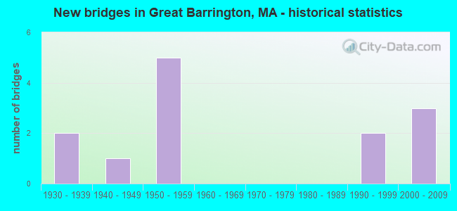
- New bridges - historical statistics
- 21930-1939
- 11940-1949
- 51950-1959
- 21990-1999
- 32000-2009


- Bridge Condition - Deck
- 54.5%Good
- 45.5%Satisfactory

- Bridge Condition - Superstructure
- 45.5%Good
- 9.1%Satisfactory
- 36.4%Fair
- 9.1%Poor

- Bridge Condition - Substructure
- 63.6%Good
- 36.4%Satisfactory

- Bridge Condition - Channel
- 7.7%Very good
- 30.8%Good
- 38.5%Satisfactory
- 23.1%Fair

- Bridge Condition - Culverts
- 50.0%Good
- 50.0%Satisfactory
Find on map >> Show street view
Structure Number: G1100304GMUNNBI, Location: AT ALFORD RD INTERSECTION (Lat: 42.216556, Lng: -73.397914), Route carried "on" structure: City street , Year Built: 1996, Status: Open, Structure Length: 1.57m (5.15ft), Average Daily Traffic: 2,845 (year 2018), Truck Traffic: 3%, Average Future Daily Traffic: 2,258 (year 2031), Design Load: HS 20, Features Intersected: WATER SEEKONK BROOK, Facility Carried by Structure: HWY DIVISION ST
Minimum Vertical Clearance: 30+ m (98+ ft), Kilometerpoint: 0.000, Lanes on structure: 2, Owner: Town or Township Highway Agency, Approaching Roadway Width: 6.6m (21.7ft), Material/Design: Prestressed concrete, Design/Construction: Box Beam or Girders - Multiple, Number Of Spans In Main Unit: 1, Length of Maximum Span: 15.2m (49.9ft), Curb-To-Curb Width: 6.6m (21.7ft), Out-to-Out Width: 7.3m (24.0ft)
Condition: Deck: Good, Superstructure: Good, Substructure: Good, Channel: Satisfactory, Operating Rating: 79.3 metric tons, Method Used To Determine Operating Rating: Allowable Stress (AS), Inventory Rating: 48.8 metric tons, Method Used To Determine Inventory Rating: Allowable Stress (AS), Structural Evaluation: Better than present minimum criteria, Deck Geometry: High priority of replacement, Waterway Adequacy: Better than present minimum criteria, Approach Roadway Alignment: Equal to present desirable criteria, Length Of Structure Improvement: 1.60m (5.25ft), Designated Inspection Frequency: Every 24 months, Inspection Date: November 2020, Bridge Improvement Cost: $1,026,000, Roadway Improvement Cost: $103,000, Total Project Cost: $1,540,000 ( Estimate for 2022), Deck Structure Type: Concrete Precast Panels, Wearing Surface/Protective System: Wearing Surface: Bituminous, Membrane: Preformed Fabric, Deck Protection: Epoxy Coated Reinforcing
Find on map >> Show street view
Structure Number: G1100604HMUNNBI, Location: 0.5M S JCT RTS41&7 (Lat: 42.198192, Lng: -73.360567), Route carried "on" structure: City street , Year Built: 1934, Year Reconstructed: 1961, Status: Closed, Structure Length: 4.08m (13.39ft), Average Daily Traffic: 240 (year 2018), Truck Traffic: 4%, Average Future Daily Traffic: 158 (year 2031), Design Load: H 20, Features Intersected: WATER HOUSATONIC RIVER, Facility Carried by Structure: HWY COTTAGE ST
Minimum Vertical Clearance: 30+ m (98+ ft), Kilometerpoint: 0.000, Lanes on structure: 2, Owner: Town or Township Highway Agency, Approaching Roadway Width: 9.1m (29.9ft), Material/Design: Steel, Design/Construction: Truss - Thru, Number Of Spans In Main Unit: 1, Length of Maximum Span: 37.5m (123.0ft), Curb or Sidewalk Widths: Left: 1.8m (5.9ft), Right: 1.0m (3.3ft), Curb-To-Curb Width: 9.1m (29.9ft), Out-to-Out Width: 12.8m (42.0ft)
Condition: Deck: Satisfactory, Superstructure: Poor, Substructure: Satisfactory, Channel: Good, Deck Geometry: Equal to present minimum criteria, Waterway Adequacy: Equal to present desirable criteria, Approach Roadway Alignment: Equal to present minimum criteria, Bridge Posting: Required (Relationship of Operating Rating to Maximum Legal Load: > 39.9% below), Length Of Structure Improvement: 5.10m (16.73ft), Designated Inspection Frequency: Every 12 months, Inspection Date: December 2021, Bridge Improvement Cost: $3,927,000, Roadway Improvement Cost: $393,000, Total Project Cost: $5,891,000 ( Estimate for 2022), Deck Structure Type: Concrete Cast-file-Place, Wearing Surface/Protective System: Wearing Surface: Bituminous, Membrane: Built-up
Find on map >> Show street view
Structure Number: G1100704JMUNNBI, Location: E OF MAIN ST N OF JCT23&7 (Lat: 42.192531, Lng: -73.359006), Route carried "on" structure: City street , Year Built: 1951, Status: Posted for load, Structure Length: 4.02m (13.19ft), Average Daily Traffic: 8,200 (year 2008), Truck Traffic: 5%, Average Future Daily Traffic: 12,950 (year 2031), Design Load: H 20, Features Intersected: WATER HOUSATONIC RIVER, Facility Carried by Structure: HWY BRIDGE ST
Minimum Vertical Clearance: 30+ m (98+ ft), Kilometerpoint: 0.370, Lanes on structure: 2, Owner: Town or Township Highway Agency, Approaching Roadway Width: 7.9m (25.9ft), Material/Design: Steel, Design/Construction: Truss - Thru, Number Of Spans In Main Unit: 1, Length of Maximum Span: 39.3m (128.9ft), Curb or Sidewalk Widths: Left: 1.5m (4.9ft), Right: 0.4m (1.3ft), Curb-To-Curb Width: 7.9m (25.9ft), Out-to-Out Width: 8.9m (29.2ft)
Condition: Deck: Satisfactory, Superstructure: Fair, Substructure: Satisfactory, Channel: Good, Operating Rating: 50.6 metric tons, Method Used To Determine Operating Rating: Load Factor (LF), Inventory Rating: 22.3 metric tons, Method Used To Determine Inventory Rating: Load Factor (LF), Structural Evaluation: Somewhat better than minimum adequacy, Deck Geometry: High priority of replacement, Waterway Adequacy: Better than present minimum criteria, Approach Roadway Alignment: Equal to present minimum criteria, Length Of Structure Improvement: 4.10m (13.45ft), Designated Inspection Frequency: Every 24 months, Critical Feature Inspection Frequency: Every 24 months, Inspection Date: June 2020, Critical Feature Inspection Date: June 2020, Bridge Improvement Cost: $1,434,000, Roadway Improvement Cost: $144,000, Total Project Cost: $2,152,000 ( Estimate for 2022), Deck Structure Type: Concrete Cast-file-Place, Wearing Surface/Protective System: Wearing Surface: Bituminous, Membrane: Built-up
Find on map >> Show street view
Structure Number: G1100804KMUNNBI, Location: E OF RT7 1.3M N OF SHFFLD (Lat: 42.176114, Lng: -73.359097), Route carried "on" structure: City street , Year Built: 1949, Status: Posted for load, Structure Length: 4.52m (14.83ft), Average Daily Traffic: 1,449 (year 2017), Truck Traffic: 6%, Average Future Daily Traffic: 158 (year 2032), Design Load: H 15, Features Intersected: WATER HOUSATONIC RIVER, Facility Carried by Structure: HWY BROOKSIDE RD
Minimum Vertical Clearance: 4.31m (14.14ft), Kilometerpoint: 0.241, Lanes on structure: 2, Owner: Town or Township Highway Agency, Approaching Roadway Width: 5.5m (18.0ft), Material/Design: Steel, Design/Construction: Truss - Thru, Number Of Spans In Main Unit: 1, Length of Maximum Span: 43.5m (142.7ft), Curb or Sidewalk Widths: Left: 0.2m (0.7ft), Right: 0.2m (0.7ft), Curb-To-Curb Width: 6.1m (20.0ft), Out-to-Out Width: 6.9m (22.6ft)
Condition: Deck: Satisfactory, Superstructure: Fair, Substructure: Satisfactory, Channel: Good, Operating Rating: 36.9 metric tons, Method Used To Determine Operating Rating: Load Factor (LF), Inventory Rating: 22.4 metric tons, Method Used To Determine Inventory Rating: Load Factor (LF), Structural Evaluation: Somewhat better than minimum adequacy, Deck Geometry: High priority of replacement, Waterway Adequacy: Better than present minimum criteria, Approach Roadway Alignment: Equal to present minimum criteria, Length Of Structure Improvement: 4.60m (15.09ft), Designated Inspection Frequency: Every 24 months, Critical Feature Inspection Frequency: Every 24 months, Inspection Date: June 2021, Critical Feature Inspection Date: June 2021, Bridge Improvement Cost: $1,247,000, Roadway Improvement Cost: $125,000, Total Project Cost: $1,871,000 ( Estimate for 2022), Deck Structure Type: Concrete Cast-file-Place, Wearing Surface/Protective System: Wearing Surface: Bituminous, Membrane: Built-up
Find on map >> Show street view
Structure Number: G11009A13DOTNBI, Location: 1MI W OF US7 (Lat: 42.179383, Lng: -73.379211), Route carried "on" structure: State highway 23, Year Built: 2004, Status: Open, Structure Length: 2.85m (9.35ft), Average Daily Traffic: 10,345 (year 2016), Truck Traffic: 8%, Average Future Daily Traffic: 18,378 (year 2031), Design Load: HS 20, Features Intersected: WATER GREEN RIVER
Minimum Vertical Clearance: 30+ m (98+ ft), Kilometerpoint: 9.814, Lanes on structure: 2, Owner: State Highway Agency, Approaching Roadway Width: 9.5m (31.2ft), Material/Design: Steel, Design/Construction: Stringer/Multi-beam, Number Of Spans In Main Unit: 1, Length of Maximum Span: 27.5m (90.2ft), Curb or Sidewalk Widths: Left: 0.0m, Right: 1.6m (5.2ft), Curb-To-Curb Width: 9.5m (31.2ft), Out-to-Out Width: 12.0m (39.4ft)
Condition: Deck: Good, Superstructure: Good, Substructure: Good, Channel: Satisfactory, Operating Rating: 74.5 metric tons, Method Used To Determine Operating Rating: Load Factor (LF), Inventory Rating: 44.7 metric tons, Method Used To Determine Inventory Rating: Load Factor (LF), Structural Evaluation: Better than present minimum criteria, Deck Geometry: High priority of corrective action, Waterway Adequacy: Better than present minimum criteria, Approach Roadway Alignment: Equal to present desirable criteria, Length Of Structure Improvement: 2.90m (9.51ft), Designated Inspection Frequency: Every 24 months, Inspection Date: Febuary 2022, Bridge Improvement Cost: $1,067,000, Roadway Improvement Cost: $107,000, Total Project Cost: $1,601,000 ( Estimate for 2022), Deck Structure Type: Concrete Cast-file-Place, Wearing Surface/Protective System: Wearing Surface: Bituminous, Membrane: Preformed Fabric, Deck Protection: Epoxy Coated Reinforcing
Find on map >> Show street view
Structure Number: G11011AVQMUNNBI, Location: 0.2M N OF RT71@EGRMNT BDR (Lat: 42.187867, Lng: -73.413261), Route carried "on" structure: City street , Year Built: 1999, Status: Open, Structure Length: 1.85m (6.07ft), Average Daily Traffic: 647 (year 2019), Truck Traffic: 6%, Average Future Daily Traffic: 316 (year 2032), Design Load: HS 20, Features Intersected: WATER GREEN RIVER, Facility Carried by Structure: HWY PUMPKIN HOLL
Minimum Vertical Clearance: 30+ m (98+ ft), Kilometerpoint: 0.241, Lanes on structure: 2, Owner: Town or Township Highway Agency, Approaching Roadway Width: 5.5m (18.0ft), Material/Design: Wood or Timber, Design/Construction: Arch - Thru, Number Of Spans In Main Unit: 1, Length of Maximum Span: 18.0m (59.1ft), Curb-To-Curb Width: 5.5m (18.0ft), Out-to-Out Width: 6.1m (20.0ft)
Condition: Deck: Good, Superstructure: Fair, Substructure: Good, Channel: Satisfactory, Operating Rating: 56.7 metric tons, Method Used To Determine Operating Rating: Allowable Stress (AS), Inventory Rating: 41.4 metric tons, Method Used To Determine Inventory Rating: Allowable Stress (AS), Structural Evaluation: Somewhat better than minimum adequacy, Deck Geometry: High priority of replacement, Waterway Adequacy: Better than present minimum criteria, Approach Roadway Alignment: Equal to present desirable criteria, Length Of Structure Improvement: 1.90m (6.23ft), Designated Inspection Frequency: Every 24 months, Critical Feature Inspection Frequency: Every 24 months, Inspection Date: May 2021, Critical Feature Inspection Date: May 2021, Bridge Improvement Cost: $456,000, Roadway Improvement Cost: $46,000, Total Project Cost: $685,000 ( Estimate for 2022), Deck Structure Type: Wood or Timber, Wearing Surface/Protective System: Wearing Surface: Bituminous, Membrane: Preformed Fabric, Deck Protection: Other
Find on map >> Show street view
Structure Number: G1101204MMUNNBI, Location: .7 MI NORTH OF ROUTE 71 (Lat: 42.190728, Lng: -73.399539), Route carried "on" structure: City street , Year Built: 1956, Status: Posted for load, Structure Length: 2.35m (7.71ft), Average Daily Traffic: 776 (year 2018), Truck Traffic: 6%, Average Future Daily Traffic: 158 (year 2032), Design Load: H 20, Features Intersected: WATER GREEN RIVER, Facility Carried by Structure: HWY SEEKONK CRSS
Minimum Vertical Clearance: 30+ m (98+ ft), Kilometerpoint: 0.000, Lanes on structure: 2, Owner: Town or Township Highway Agency, Approaching Roadway Width: 7.6m (24.9ft), Skew: 1 degrees, Material/Design: Steel continuous, Design/Construction: Stringer/Multi-beam, Number Of Spans In Main Unit: 3, Length of Maximum Span: 12.2m (40.0ft), Curb or Sidewalk Widths: Left: 0.2m (0.7ft), Right: 0.2m (0.7ft), Curb-To-Curb Width: 8.5m (27.9ft), Out-to-Out Width: 10.0m (32.8ft)
Condition: Deck: Satisfactory, Superstructure: Satisfactory, Substructure: Good, Channel: Fair, Operating Rating: 95.1 metric tons, Method Used To Determine Operating Rating: Load Factor (LF), Inventory Rating: 56.9 metric tons, Method Used To Determine Inventory Rating: Load Factor (LF), Structural Evaluation: Equal to present minimum criteria, Deck Geometry: Somewhat better than minimum adequacy, Waterway Adequacy: Equal to present minimum criteria, Approach Roadway Alignment: Equal to present desirable criteria, Length Of Structure Improvement: 2.40m (7.87ft), Designated Inspection Frequency: Every 24 months, Inspection Date: November 2020, Bridge Improvement Cost: $838,000, Roadway Improvement Cost: $84,000, Total Project Cost: $1,258,000 ( Estimate for 2022), Deck Structure Type: Concrete Cast-file-Place, Wearing Surface/Protective System: Wearing Surface: Bituminous
Find on map >> Show street view
Structure Number: G1101304NMUNNBI, Location: 1.5M N JCT RTS23&71 (Lat: 42.192628, Lng: -73.391325), Route carried "on" structure: City street , Year Built: 1958, Status: Open, Structure Length: 4.72m (15.49ft), Average Daily Traffic: 1,164 (year 2018), Truck Traffic: 6%, Average Future Daily Traffic: 474 (year 2033), Design Load: H 20, Features Intersected: WATER GREEN RIVER, Facility Carried by Structure: HWY HURLBURT RD
Minimum Vertical Clearance: 30+ m (98+ ft), Kilometerpoint: 0.000, Lanes on structure: 2, Owner: Town or Township Highway Agency, Approaching Roadway Width: 7.3m (24.0ft), Skew: 4 degrees, Material/Design: Steel continuous, Design/Construction: Stringer/Multi-beam, Number Of Spans In Main Unit: 3, Length of Maximum Span: 21.9m (71.9ft), Curb or Sidewalk Widths: Left: 0.3m (1.0ft), Right: 0.3m (1.0ft), Curb-To-Curb Width: 7.3m (24.0ft), Out-to-Out Width: 8.7m (28.5ft)
Condition: Deck: Good, Superstructure: Good, Substructure: Good, Channel: Fair, Operating Rating: 51.6 metric tons, Method Used To Determine Operating Rating: Load Factor (LF), Inventory Rating: 30.9 metric tons, Method Used To Determine Inventory Rating: Load Factor (LF), Structural Evaluation: Better than present minimum criteria, Deck Geometry: Meets minimum limits, Waterway Adequacy: Equal to present desirable criteria, Approach Roadway Alignment: Somewhat better than minimum adequacy, Length Of Structure Improvement: 4.80m (15.75ft), Designated Inspection Frequency: Every 24 months, Inspection Date: Febuary 2022, Bridge Improvement Cost: $1,641,000, Roadway Improvement Cost: $165,000, Total Project Cost: $2,462,000 ( Estimate for 2022), Deck Structure Type: Concrete Cast-file-Place, Wearing Surface/Protective System: Wearing Surface: Bituminous, Membrane: Preformed Fabric
Find on map >> Show street view
Structure Number: G1101409MDOTNBI, Location: 3.0 MI N OF SHEFFLD TL (Lat: 42.201417, Lng: -73.357858), Route carried "on" structure: US 7, Year Built: 1931, Status: Posted for load, Structure Length: 3.63m (11.91ft), Average Daily Traffic: 13,813 (year 2018), Truck Traffic: 9%, Average Future Daily Traffic: 28,427 (year 2032), Design Load: H 20, Features Intersected: WATER HOUSATONIC RIVER
Minimum Vertical Clearance: 30+ m (98+ ft), Kilometerpoint: 18.426, Lanes on structure: 2, Base Highway Network: Yes, Owner: State Highway Agency, Approaching Roadway Width: 12.2m (40.0ft), Material/Design: Steel, Design/Construction: Truss - Thru, Number Of Spans In Main Unit: 1, Length of Maximum Span: 33.1m (108.6ft), Curb or Sidewalk Widths: Left: 0.3m (1.0ft), Right: 1.8m (5.9ft), Curb-To-Curb Width: 12.2m (40.0ft), Out-to-Out Width: 13.3m (43.6ft)
Condition: Deck: Satisfactory, Superstructure: Fair, Substructure: Satisfactory, Channel: Good, Operating Rating: 44.4 metric tons, Method Used To Determine Operating Rating: Load Factor (LF), Inventory Rating: 28.2 metric tons, Method Used To Determine Inventory Rating: Load Factor (LF), Structural Evaluation: Somewhat better than minimum adequacy, Deck Geometry: Somewhat better than minimum adequacy, Waterway Adequacy: Equal to present desirable criteria, Approach Roadway Alignment: Equal to present minimum criteria, Length Of Structure Improvement: 3.70m (12.14ft), Designated Inspection Frequency: Every 24 months, Critical Feature Inspection Frequency: Every 24 months, Inspection Date: July 2021, Critical Feature Inspection Date: July 2021, Bridge Improvement Cost: $1,933,000, Roadway Improvement Cost: $194,000, Total Project Cost: $2,900,000 ( Estimate for 2022), Deck Structure Type: Concrete Cast-file-Place, Wearing Surface/Protective System: Wearing Surface: Bituminous, Membrane: Preformed Fabric
Find on map >> Show street view
Structure Number: G11019ANNDOTNBI, Location: 0.2 MI N OF SHEFFIELD TL (Lat: 42.163514, Lng: -73.364967), Route carried "on" structure: US 7, Year Built: 2002, Status: Open, Structure Length: 4.35m (14.27ft), Average Daily Traffic: 15,400 (year 2012), Truck Traffic: 18%, Average Future Daily Traffic: 15,951 (year 2031), Design Load: HS 20, Features Intersected: WATER GREEN RIVER
Minimum Vertical Clearance: 30+ m (98+ ft), Kilometerpoint: 13.991, Lanes on structure: 2, Owner: State Highway Agency, Approaching Roadway Width: 12.2m (40.0ft), Skew: 1 degrees, Material/Design: Steel, Design/Construction: Box Beam or Girders - Multiple, Number Of Spans In Main Unit: 1, Length of Maximum Span: 42.5m (139.4ft), Curb or Sidewalk Widths: Left: 0.1m (0.3ft), Right: 1.8m (5.9ft), Curb-To-Curb Width: 12.2m (40.0ft), Out-to-Out Width: 14.8m (48.6ft)
Condition: Deck: Good, Superstructure: Good, Substructure: Good, Channel: Satisfactory, Operating Rating: 85.6 metric tons, Method Used To Determine Operating Rating: Load Factor (LF), Inventory Rating: 51.3 metric tons, Method Used To Determine Inventory Rating: Load Factor (LF), Structural Evaluation: Better than present minimum criteria, Deck Geometry: Somewhat better than minimum adequacy, Waterway Adequacy: Better than present minimum criteria, Approach Roadway Alignment: Equal to present desirable criteria, Length Of Structure Improvement: 4.40m (14.44ft), Designated Inspection Frequency: Every 24 months, Inspection Date: October 2020, Bridge Improvement Cost: $498,000, Roadway Improvement Cost: $50,000, Total Project Cost: $748,000 ( Estimate for 2022), Deck Structure Type: Concrete Cast-file-Place, Wearing Surface/Protective System: Wearing Surface: Bituminous, Membrane: Preformed Fabric, Deck Protection: Epoxy Coated Reinforcing
Find on map >> Show street view
Structure Number: G1102109NDOTNBI, Location: AT ST.PETERS/ELMWOOD CEM. (Lat: 42.203519, Lng: -73.346897), Route carried "on" structure: US 7, Year Built: 1953, Status: Open, Structure Length: 0.82m (2.69ft), Average Daily Traffic: 11,448 (year 2017), Truck Traffic: 10%, Average Future Daily Traffic: 28,585 (year 2032), Design Load: H 20, Features Intersected: WATER TOM PALMER BROOK
Minimum Vertical Clearance: 30+ m (98+ ft), Kilometerpoint: 19.553, Lanes on structure: 3, Base Highway Network: Yes, Owner: State Highway Agency, Approaching Roadway Width: 12.2m (40.0ft), Material/Design: Concrete, Design/Construction: Culvert, Number Of Spans In Main Unit: 2, Length of Maximum Span: 3.7m (12.1ft), Curb or Sidewalk Widths: Left: 1.5m (4.9ft), Right: 1.5m (4.9ft), Curb-To-Curb Width: 12.2m (40.0ft), Out-to-Out Width: 16.5m (54.1ft)
Condition: Channel: Fair, Culverts: Good, Operating Rating: 41.7 metric tons, Method Used To Determine Operating Rating: Load Factor (LF), Inventory Rating: 25.0 metric tons, Method Used To Determine Inventory Rating: Load Factor (LF), Structural Evaluation: Equal to present minimum criteria, Deck Geometry: Meets minimum limits, Waterway Adequacy: Equal to present desirable criteria, Approach Roadway Alignment: Equal to present desirable criteria, Length Of Structure Improvement: 1.30m (4.27ft), Designated Inspection Frequency: Every 24 months, Inspection Date: November 2021, Bridge Improvement Cost: $419,000, Roadway Improvement Cost: $42,000, Total Project Cost: $629,000 ( Estimate for 2022)
Find on map >> Show street view
Structure Number: G11029AFTMUNNBI, Location: 100' WEST OF ALFORD RD (Lat: 42.213100, Lng: -73.391483), Route carried "on" structure: City street , Year Built: 2003, Status: Open, Structure Length: 1.65m (5.41ft), Average Daily Traffic: 457 (year 2017), Truck Traffic: 6%, Average Future Daily Traffic: 450 (year 2032), Design Load: HS 20, Features Intersected: WATER SEEKONK BROOK, Facility Carried by Structure: HWY SEEKONK RD
Minimum Vertical Clearance: 30+ m (98+ ft), Kilometerpoint: 0.000, Lanes on structure: 2, Owner: Town or Township Highway Agency, Approaching Roadway Width: 7.2m (23.6ft), Material/Design: Prestressed concrete, Design/Construction: Box Beam or Girders - Multiple, Number Of Spans In Main Unit: 1, Length of Maximum Span: 15.4m (50.5ft), Curb or Sidewalk Widths: Left: 0.0m, Right: 1.6m (5.2ft), Curb-To-Curb Width: 7.2m (23.6ft), Out-to-Out Width: 9.7m (31.8ft)
Condition: Deck: Good, Superstructure: Good, Substructure: Good, Channel: Very good, Inventory Rating: 86.1 metric tons, Method Used To Determine Inventory Rating: Load Factor (LF), Structural Evaluation: Better than present minimum criteria, Deck Geometry: Meets minimum limits, Waterway Adequacy: Better than present minimum criteria, Approach Roadway Alignment: Equal to present minimum criteria, Length Of Structure Improvement: 1.70m (5.58ft), Designated Inspection Frequency: Every 24 months, Inspection Date: November 2020, Bridge Improvement Cost: $802,000, Roadway Improvement Cost: $81,000, Total Project Cost: $1,204,000 ( Estimate for 2022), Deck Structure Type: Concrete Cast-file-Place, Wearing Surface/Protective System: Wearing Surface: Monolithic Concrete, Deck Protection: Epoxy Coated Reinforcing
Find on map >> Show street view
Structure Number: G110300C9DOTNBI, Location: 150' E. OF E. MOUNTAIN RD (Lat: 42.191567, Lng: -73.330986), Route carried "on" structure: State highway 23, Year Built: 1950, Status: Open, Structure Length: 1.07m (3.51ft), Average Daily Traffic: 7,000 (year 2011), Truck Traffic: 6%, Average Future Daily Traffic: 11,055 (year 2032), Features Intersected: WATER TOM PALMER BROOK
Minimum Vertical Clearance: 30+ m (98+ ft), Kilometerpoint: 15.686, Lanes on structure: 2, Owner: State Highway Agency, Approaching Roadway Width: 13.4m (44.0ft), Skew: 7 degrees, Material/Design: Concrete, Design/Construction: Culvert, Number Of Spans In Main Unit: 1, Length of Maximum Span: 10.1m (33.1ft), Curb-To-Curb Width: 13.4m (44.0ft), Out-to-Out Width: 15.2m (49.9ft)
Condition: Channel: Satisfactory, Culverts: Satisfactory, Operating Rating: 47.3 metric tons, Method Used To Determine Operating Rating: Load Factor (LF), Inventory Rating: 28.2 metric tons, Method Used To Determine Inventory Rating: Load Factor (LF), Structural Evaluation: Equal to present minimum criteria, Deck Geometry: Equal to present minimum criteria, Waterway Adequacy: Equal to present desirable criteria, Approach Roadway Alignment: Equal to present desirable criteria, Length Of Structure Improvement: 4.00m (13.12ft), Designated Inspection Frequency: Every 24 months, Inspection Date: November 2021, Bridge Improvement Cost: $575,000, Roadway Improvement Cost: $58,000, Total Project Cost: $863,000 ( Estimate for 2022), Deck Structure Type: Concrete Cast-file-Place, Wearing Surface/Protective System: Wearing Surface: Bituminous