Bridge Statistics for Greenfield, Tennessee (TN)
Condition, Traffic, Stress, Structural Evaluation, Project Costs
- National Bridge Inventory (NBI) Statistics
- 22Number of bridges
- 308ft / 94.4mTotal length
- $17,729,000Total costs
- 40,156Total average daily traffic
- 3,863Total average daily truck traffic
- 68,272Total future (year 2039) average daily traffic
- National Bridge Inventory (NBI) Registered Bridges for Greenfield
- No street view available for this location
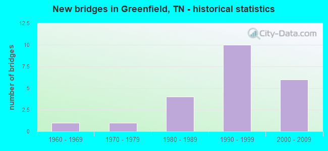
- New bridges - historical statistics
- 11960-1969
- 11970-1979
- 41980-1989
- 101990-1999
- 62000-2009


- Bridge Condition - Deck
- 64.3%Good
- 28.6%Satisfactory
- 7.1%Fair

- Bridge Condition - Superstructure
- 28.6%Good
- 57.1%Satisfactory
- 14.3%Fair

- Bridge Condition - Substructure
- 78.6%Good
- 21.4%Satisfactory

- Bridge Condition - Channel
- 27.3%Good
- 68.2%Satisfactory
- 4.5%Fair
Find on map >> Show street view
Structure Number: 27015930013, Location: 3.3 MI NW JCT SR43&SRU05 (Lat: 36.128194, Lng: -88.849722), Route carried "on" structure: County highway 1593, Year Built: 1988, Status: Open, Structure Length: 4.66m (15.29ft), Average Daily Traffic: 231 (year 2020), Truck Traffic: 3%, Average Future Daily Traffic: 352 (year 2039), Design Load: HS 20, Features Intersected: SOUTH FORK OBION RIVER
Minimum Vertical Clearance: 30+ m (98+ ft), Kilometerpoint: 12.939, Lanes on structure: 2, Owner: County Highway Agency, Approaching Roadway Width: 6.4m (21.0ft), Material/Design: Steel continuous, Design/Construction: Stringer/Multi-beam, Number Of Spans In Main Unit: 3, Length of Maximum Span: 17.1m (56.1ft), Curb-To-Curb Width: 6.7m (22.0ft), Out-to-Out Width: 7.6m (24.9ft)
Condition: Deck: Good, Superstructure: Good, Substructure: Good, Channel: Satisfactory, Operating Rating: 44.1 metric tons, Method Used To Determine Operating Rating: Assigned rating based on Load Factor Design (LFD) reported in metric tons, Inventory Rating: 32.4 metric tons, Method Used To Determine Inventory Rating: Assigned rating based on Load Factor Design (LFD) reported in metric tons, Structural Evaluation: Better than present minimum criteria, Deck Geometry: Meets minimum limits, Waterway Adequacy: Equal to present desirable criteria, Approach Roadway Alignment: Equal to present desirable criteria, Length Of Structure Improvement: 4.66m (15.29ft), Designated Inspection Frequency: Every 24 months, Inspection Date: July 2021, Bridge Improvement Cost: $221,000, Roadway Improvement Cost: $23,000, Total Project Cost: $332,000 ( Estimate for 2019), Deck Structure Type: Concrete Cast-file-Place, Wearing Surface/Protective System: Wearing Surface: Integral Concrete
Find on map >> Show street view
Structure Number: 27015930019, Location: 3.6 MI NW JCT SR43&SR105 (Lat: 36.132361, Lng: -88.848667), Route carried "on" structure: County highway 1593, Year Built: 2005, Status: Open, Structure Length: 3.05m (10.01ft), Average Daily Traffic: 231 (year 2020), Truck Traffic: 3%, Average Future Daily Traffic: 352 (year 2039), Design Load: HS 20+Mod, Features Intersected: OVERFLOW S FORK OBION
Minimum Vertical Clearance: 30+ m (98+ ft), Kilometerpoint: 13.422, Lanes on structure: 2, Owner: County Highway Agency, Approaching Roadway Width: 8.5m (27.9ft), Material/Design: Prestressed concrete, Design/Construction: Box Beam or Girders - Single/Spread, Number Of Spans In Main Unit: 1, Length of Maximum Span: 30.2m (99.1ft), Curb-To-Curb Width: 8.5m (27.9ft), Out-to-Out Width: 9.2m (30.2ft)
Condition: Deck: Good, Superstructure: Good, Substructure: Good, Channel: Good, Operating Rating: 89.1 metric tons, Method Used To Determine Operating Rating: Load Factor (LF), Inventory Rating: 32.4 metric tons, Method Used To Determine Inventory Rating: Load Factor (LF), Structural Evaluation: Better than present minimum criteria, Deck Geometry: Equal to present minimum criteria, Waterway Adequacy: Equal to present desirable criteria, Approach Roadway Alignment: Equal to present desirable criteria, Designated Inspection Frequency: Every 24 months, Inspection Date: July 2021, Deck Structure Type: Concrete Cast-file-Place, Wearing Surface/Protective System: Wearing Surface: Monolithic Concrete, Deck Protection: Epoxy Coated Reinforcing
Find on map >> Show street view
Structure Number: 27SR0430021, Location: .3 MI.S.OF WEAKLEY CO. (Lat: 36.113028, Lng: -88.811083), Route carried "on" structure: US 45, Year Built: 1996, Status: Open, Structure Length: 8.69m (28.51ft), Average Daily Traffic: 6,830 (year 2020), Truck Traffic: 11%, Average Future Daily Traffic: 10,928 (year 2042), Design Load: HS 20, Features Intersected: OVERFLOW, Facility Carried by Structure: FAP 43
Minimum Vertical Clearance: 30+ m (98+ ft), Kilometerpoint: 38.657, Lanes on structure: 5, Base Highway Network: Yes, Owner: State Highway Agency, Approaching Roadway Width: 29.2m (95.8ft), Skew: 1 degrees, Material/Design: Prestressed concrete continuous, Design/Construction: Stringer/Multi-beam, Number Of Spans In Main Unit: 5, Length of Maximum Span: 17.4m (57.1ft), Curb-To-Curb Width: 26.8m (87.9ft), Out-to-Out Width: 27.4m (89.9ft)
Condition: Deck: Good, Superstructure: Satisfactory, Substructure: Good, Channel: Satisfactory, Operating Rating: 59.4 metric tons, Method Used To Determine Operating Rating: Load Factor (LF), Inventory Rating: 32.4 metric tons, Method Used To Determine Inventory Rating: Load Factor (LF), Structural Evaluation: Equal to present minimum criteria, Deck Geometry: Superior to present desirable criteria, Waterway Adequacy: Equal to present desirable criteria, Approach Roadway Alignment: Equal to present desirable criteria, Designated Inspection Frequency: Every 24 months, Inspection Date: June 2021, Deck Structure Type: Concrete Precast Panels, Wearing Surface/Protective System: Wearing Surface: Monolithic Concrete, Deck Protection: Epoxy Coated Reinforcing
Find on map >> Show street view
Structure Number: 27SR0430023, Location: AT WEAKLEY CO. LINE (Lat: 36.115444, Lng: -88.810833), Route carried "on" structure: US 45, Year Built: 1996, Status: Open, Structure Length: 8.69m (28.51ft), Average Daily Traffic: 6,830 (year 2020), Truck Traffic: 11%, Average Future Daily Traffic: 10,928 (year 2042), Design Load: HS 20, Features Intersected: OVERFLOW, Facility Carried by Structure: FAP 43
Minimum Vertical Clearance: 30+ m (98+ ft), Kilometerpoint: 38.930, Lanes on structure: 5, Base Highway Network: Yes, Owner: State Highway Agency, Approaching Roadway Width: 21.9m (71.9ft), Skew: 1 degrees, Material/Design: Prestressed concrete continuous, Design/Construction: Stringer/Multi-beam, Number Of Spans In Main Unit: 5, Length of Maximum Span: 17.4m (57.1ft), Curb-To-Curb Width: 26.8m (87.9ft), Out-to-Out Width: 27.4m (89.9ft)
Condition: Deck: Good, Superstructure: Satisfactory, Substructure: Good, Channel: Good, Operating Rating: 59.4 metric tons, Method Used To Determine Operating Rating: Load Factor (LF), Inventory Rating: 32.4 metric tons, Method Used To Determine Inventory Rating: Load Factor (LF), Structural Evaluation: Equal to present minimum criteria, Deck Geometry: Superior to present desirable criteria, Waterway Adequacy: Equal to present desirable criteria, Approach Roadway Alignment: Equal to present desirable criteria, Designated Inspection Frequency: Every 24 months, Inspection Date: June 2021, Deck Structure Type: Concrete Precast Panels, Wearing Surface/Protective System: Wearing Surface: Monolithic Concrete, Deck Protection: Epoxy Coated Reinforcing
Find on map >> Show street view
Structure Number: 920A3850001, Location: 1 MI S OF GREENFIELD (Lat: 36.141444, Lng: -88.786889), Route carried "on" structure: County highway 385, Year Built: 2003, Status: Open, Structure Length: 1.08m (3.54ft), Average Daily Traffic: 200 (year 2022), Truck Traffic: 2%, Average Future Daily Traffic: 320 (year 2040), Design Load: HS 20, Features Intersected: MOSLEY BRANCH
Minimum Vertical Clearance: 30+ m (98+ ft), Kilometerpoint: 8.774, Lanes on structure: 2, Owner: County Highway Agency, Approaching Roadway Width: 7.9m (25.9ft), Skew: 1 degrees, Material/Design: Concrete continuous, Design/Construction: Culvert, Number Of Spans In Main Unit: 2, Length of Maximum Span: 4.9m (16.1ft), Curb-To-Curb Width: 7.9m (25.9ft), Out-to-Out Width: 10.4m (34.1ft)
Condition: Channel: Satisfactory, Culverts: Satisfactory, Operating Rating: 44.1 metric tons, Method Used To Determine Operating Rating: Assigned rating based on Load Factor Design (LFD) reported in metric tons, Inventory Rating: 32.4 metric tons, Method Used To Determine Inventory Rating: Assigned rating based on Load Factor Design (LFD) reported in metric tons, Structural Evaluation: Equal to present minimum criteria, Deck Geometry: Somewhat better than minimum adequacy, Waterway Adequacy: Equal to present minimum criteria, Approach Roadway Alignment: Equal to present minimum criteria, Designated Inspection Frequency: Every 24 months, Inspection Date: September 2020, Deck Structure Type: Concrete Cast-file-Place, Wearing Surface/Protective System: Wearing Surface: Bituminous
Find on map >> Show street view
Structure Number: 920A3900001, Location: 0.5 MI N OF SR124 (Lat: 36.163806, Lng: -88.764028), Route carried "on" structure: County highway 390, Year Built: 1998, Status: Open, Structure Length: 1.49m (4.89ft), Average Daily Traffic: 80 (year 2022), Truck Traffic: 2%, Average Future Daily Traffic: 128 (year 2040), Design Load: HS 20, Features Intersected: BRANCH
Minimum Vertical Clearance: 30+ m (98+ ft), Kilometerpoint: 1.012, Lanes on structure: 2, Owner: County Highway Agency, Approaching Roadway Width: 7.0m (23.0ft), Material/Design: Concrete continuous, Design/Construction: Culvert, Number Of Spans In Main Unit: 3, Length of Maximum Span: 4.6m (15.1ft), Curb-To-Curb Width: 7.1m (23.3ft), Out-to-Out Width: 8.9m (29.2ft)
Condition: Channel: Satisfactory, Culverts: Satisfactory, Operating Rating: 89.9 metric tons, Method Used To Determine Operating Rating: Load Factor (LF), Inventory Rating: 32.4 metric tons, Method Used To Determine Inventory Rating: Load Factor (LF), Structural Evaluation: Equal to present minimum criteria, Deck Geometry: Somewhat better than minimum adequacy, Waterway Adequacy: Equal to present minimum criteria, Approach Roadway Alignment: Equal to present desirable criteria, Designated Inspection Frequency: Every 24 months, Inspection Date: September 2020, Deck Structure Type: Concrete Cast-file-Place
Find on map >> Show street view
Structure Number: 920A3960001, Location: 2.5 MI S OF GREENFIELD (Lat: 36.129972, Lng: -88.781972), Route carried "on" structure: County highway 396, Year Built: 2003, Status: Open, Structure Length: 1.98m (6.50ft), Average Daily Traffic: 40 (year 2022), Truck Traffic: 2%, Average Future Daily Traffic: 64 (year 2040), Design Load: HS 20+Mod, Features Intersected: COTTNELL BRANCH
Minimum Vertical Clearance: 30+ m (98+ ft), Kilometerpoint: 2.456, Lanes on structure: 2, Owner: County Highway Agency, Approaching Roadway Width: 7.3m (24.0ft), Skew: 4 degrees, Material/Design: Prestressed concrete, Design/Construction: Box Beam or Girders - Single/Spread, Number Of Spans In Main Unit: 1, Length of Maximum Span: 19.8m (65.0ft), Curb-To-Curb Width: 7.3m (24.0ft), Out-to-Out Width: 7.4m (24.3ft)
Condition: Deck: Good, Superstructure: Satisfactory, Substructure: Good, Channel: Satisfactory, Operating Rating: 51.3 metric tons, Method Used To Determine Operating Rating: Load Factor (LF), Inventory Rating: 31.5 metric tons, Method Used To Determine Inventory Rating: Load Factor (LF), Structural Evaluation: Equal to present minimum criteria, Deck Geometry: High priority of replacement, Waterway Adequacy: Somewhat better than minimum adequacy, Approach Roadway Alignment: Equal to present desirable criteria, Designated Inspection Frequency: Every 24 months, Inspection Date: September 2020, Deck Structure Type: Concrete Precast Panels, Wearing Surface/Protective System: Wearing Surface: Monolithic Concrete, Deck Protection: Epoxy Coated Reinforcing
Find on map >> Show street view
Structure Number: 920A4200001, Location: 1 MI N OF GREENFILD (Lat: 36.167444, Lng: -88.818722), Route carried "on" structure: County highway 420, Year Built: 1984, Status: Open, Structure Length: 1.16m (3.81ft), Average Daily Traffic: 230 (year 2022), Truck Traffic: 2%, Average Future Daily Traffic: 368 (year 2040), Design Load: HS 20, Features Intersected: BUCKOR DITCH
Minimum Vertical Clearance: 30+ m (98+ ft), Kilometerpoint: 2.005, Lanes on structure: 2, Owner: County Highway Agency, Approaching Roadway Width: 7.3m (24.0ft), Skew: 3 degrees, Material/Design: Concrete continuous, Design/Construction: Culvert, Number Of Spans In Main Unit: 2, Length of Maximum Span: 4.6m (15.1ft), Curb-To-Curb Width: 6.8m (22.3ft), Out-to-Out Width: 7.9m (25.9ft)
Condition: Channel: Satisfactory, Culverts: Satisfactory, Operating Rating: 89.9 metric tons, Method Used To Determine Operating Rating: Load Factor (LF), Inventory Rating: 32.4 metric tons, Method Used To Determine Inventory Rating: Load Factor (LF), Structural Evaluation: Equal to present minimum criteria, Deck Geometry: Meets minimum limits, Waterway Adequacy: Equal to present desirable criteria, Approach Roadway Alignment: Equal to present desirable criteria, Designated Inspection Frequency: Every 24 months, Inspection Date: September 2020, Deck Structure Type: Concrete Cast-file-Place
Find on map >> Show street view
Structure Number: 920A4200003, Location: 2 MI NW OF GREENFIELD (Lat: 36.168528, Lng: -88.833722), Route carried "on" structure: County highway 420, Year Built: 1984, Status: Open, Structure Length: 1.04m (3.41ft), Average Daily Traffic: 230 (year 2022), Truck Traffic: 2%, Average Future Daily Traffic: 368 (year 2040), Design Load: HS 20, Features Intersected: LIPSCOMB DITCH
Minimum Vertical Clearance: 30+ m (98+ ft), Kilometerpoint: 3.370, Lanes on structure: 2, Owner: County Highway Agency, Approaching Roadway Width: 7.9m (25.9ft), Material/Design: Concrete continuous, Design/Construction: Culvert, Number Of Spans In Main Unit: 2, Length of Maximum Span: 4.6m (15.1ft), Curb-To-Curb Width: 6.9m (22.6ft), Out-to-Out Width: 8.0m (26.2ft)
Condition: Channel: Satisfactory, Culverts: Satisfactory, Operating Rating: 89.9 metric tons, Method Used To Determine Operating Rating: Load Factor (LF), Inventory Rating: 32.4 metric tons, Method Used To Determine Inventory Rating: Load Factor (LF), Structural Evaluation: Equal to present minimum criteria, Deck Geometry: Meets minimum limits, Waterway Adequacy: Equal to present desirable criteria, Approach Roadway Alignment: Equal to present desirable criteria, Designated Inspection Frequency: Every 24 months, Inspection Date: September 2020, Deck Structure Type: Concrete Cast-file-Place, Wearing Surface/Protective System: Wearing Surface: Bituminous
Find on map >> Show street view
Structure Number: 920A4560001, Location: 2 MI W OF SR43 (Lat: 36.190028, Lng: -88.835139), Route carried "on" structure: County highway 456, Year Built: 1997, Status: Open, Structure Length: 0.79m (2.59ft), Average Daily Traffic: 10 (year 2022), Truck Traffic: 2%, Average Future Daily Traffic: 16 (year 2040), Design Load: HS 20, Features Intersected: LIPSCOMB DITCH
Minimum Vertical Clearance: 30+ m (98+ ft), Kilometerpoint: 1.703, Lanes on structure: 2, Owner: County Highway Agency, Approaching Roadway Width: 8.2m (26.9ft), Skew: 1 degrees, Material/Design: Concrete continuous, Design/Construction: Culvert, Number Of Spans In Main Unit: 2, Length of Maximum Span: 3.4m (11.2ft), Curb-To-Curb Width: 7.9m (25.9ft), Out-to-Out Width: 8.4m (27.6ft)
Condition: Channel: Satisfactory, Culverts: Satisfactory, Operating Rating: 89.1 metric tons, Method Used To Determine Operating Rating: Load Factor (LF), Inventory Rating: 32.4 metric tons, Method Used To Determine Inventory Rating: Load Factor (LF), Structural Evaluation: Equal to present minimum criteria, Deck Geometry: Equal to present minimum criteria, Waterway Adequacy: Better than present minimum criteria, Approach Roadway Alignment: Equal to present minimum criteria, Designated Inspection Frequency: Every 24 months, Inspection Date: September 2020, Deck Structure Type: Concrete Cast-file-Place
Find on map >> Show street view
Structure Number: 920A4640001, Location: 2 MI S OF KY (Lat: 36.176667, Lng: -88.856611), Route carried "on" structure: County highway 461, Year Built: 2002, Status: Open, Structure Length: 1.29m (4.23ft), Average Daily Traffic: 10 (year 2022), Truck Traffic: 2%, Average Future Daily Traffic: 16 (year 2040), Design Load: HS 20, Features Intersected: CAPP BRANCH
Minimum Vertical Clearance: 30+ m (98+ ft), Kilometerpoint: 0.496, Lanes on structure: 2, Owner: County Highway Agency, Approaching Roadway Width: 4.9m (16.1ft), Material/Design: Concrete continuous, Design/Construction: Slab, Number Of Spans In Main Unit: 3, Length of Maximum Span: 5.5m (18.0ft), Curb-To-Curb Width: 7.4m (24.3ft), Out-to-Out Width: 7.9m (25.9ft)
Condition: Deck: Satisfactory, Superstructure: Satisfactory, Substructure: Good, Channel: Good, Operating Rating: 44.1 metric tons, Method Used To Determine Operating Rating: Assigned rating based on Load Factor Design (LFD) reported in metric tons, Inventory Rating: 32.4 metric tons, Method Used To Determine Inventory Rating: Assigned rating based on Load Factor Design (LFD) reported in metric tons, Structural Evaluation: Equal to present minimum criteria, Deck Geometry: Equal to present minimum criteria, Waterway Adequacy: Equal to present desirable criteria, Approach Roadway Alignment: Equal to present desirable criteria, Designated Inspection Frequency: Every 24 months, Inspection Date: September 2020, Deck Structure Type: Concrete Cast-file-Place
Find on map >> Show street view
Structure Number: 920A4710001, Location: 0.5 MI W OF SR43 (Lat: 36.185306, Lng: -88.819583), Route carried "on" structure: County highway 471, Year Built: 2002, Status: Open, Structure Length: 1.72m (5.64ft), Average Daily Traffic: 130 (year 2022), Truck Traffic: 2%, Average Future Daily Traffic: 208 (year 2040), Design Load: HS 20, Features Intersected: BUCKOR DITCH
Minimum Vertical Clearance: 30+ m (98+ ft), Kilometerpoint: 0.660, Lanes on structure: 2, Owner: County Highway Agency, Approaching Roadway Width: 7.3m (24.0ft), Skew: 3 degrees, Material/Design: Concrete continuous, Design/Construction: Culvert, Number Of Spans In Main Unit: 3, Length of Maximum Span: 4.6m (15.1ft), Curb-To-Curb Width: 7.4m (24.3ft), Out-to-Out Width: 9.2m (30.2ft)
Condition: Channel: Satisfactory, Culverts: Satisfactory, Operating Rating: 89.9 metric tons, Method Used To Determine Operating Rating: Load Factor (LF), Inventory Rating: 32.4 metric tons, Method Used To Determine Inventory Rating: Load Factor (LF), Structural Evaluation: Equal to present minimum criteria, Deck Geometry: Somewhat better than minimum adequacy, Waterway Adequacy: Equal to present desirable criteria, Approach Roadway Alignment: Equal to present desirable criteria, Designated Inspection Frequency: Every 24 months, Inspection Date: September 2020, Deck Structure Type: Concrete Cast-file-Place
Find on map >> Show street view
Structure Number: 920A4710003, Location: 0.4 MI W OF SR43 (Lat: 36.185472, Lng: -88.818972), Route carried "on" structure: County highway 471, Year Built: 2001, Status: Open, Structure Length: 1.33m (4.36ft), Average Daily Traffic: 130 (year 2022), Truck Traffic: 2%, Average Future Daily Traffic: 208 (year 2040), Design Load: HS 15, Features Intersected: BRANCH
Minimum Vertical Clearance: 30+ m (98+ ft), Kilometerpoint: 0.718, Lanes on structure: 2, Owner: County Highway Agency, Approaching Roadway Width: 7.6m (24.9ft), Skew: 1 degrees, Material/Design: Concrete continuous, Design/Construction: Slab, Number Of Spans In Main Unit: 3, Length of Maximum Span: 4.4m (14.4ft), Curb-To-Curb Width: 7.3m (24.0ft), Out-to-Out Width: 7.8m (25.6ft)
Condition: Deck: Good, Superstructure: Good, Substructure: Good, Channel: Satisfactory, Operating Rating: 36.0 metric tons, Method Used To Determine Operating Rating: Field evaluation and documented engineering judgment, Inventory Rating: 24.3 metric tons, Method Used To Determine Inventory Rating: Field evaluation and documented engineering judgment, Structural Evaluation: Equal to present minimum criteria, Deck Geometry: Somewhat better than minimum adequacy, Waterway Adequacy: Equal to present minimum criteria, Approach Roadway Alignment: Equal to present desirable criteria, Designated Inspection Frequency: Every 24 months, Inspection Date: September 2020, Deck Structure Type: Concrete Cast-file-Place
Find on map >> Show street view
Structure Number: 920A4720001, Location: 1.8 MI E OF SR54 (Lat: 36.174944, Lng: -88.756444), Route carried "on" structure: County highway 472, Year Built: 1975, Status: Open, Structure Length: 1.46m (4.79ft), Average Daily Traffic: 40 (year 2022), Truck Traffic: 2%, Average Future Daily Traffic: 64 (year 2040), Design Load: H 10, Features Intersected: DOLAND BRANCH
Minimum Vertical Clearance: 30+ m (98+ ft), Kilometerpoint: 3.945, Lanes on structure: 2, Owner: County Highway Agency, Approaching Roadway Width: 7.3m (24.0ft), Skew: 1 degrees, Material/Design: Concrete, Design/Construction: Channel Beam, Number Of Spans In Main Unit: 2, Length of Maximum Span: 8.8m (28.9ft), Curb-To-Curb Width: 7.3m (24.0ft), Out-to-Out Width: 7.7m (25.3ft)
Condition: Deck: Fair, Superstructure: Fair, Substructure: Satisfactory, Channel: Satisfactory, Operating Rating: 36.0 metric tons, Method Used To Determine Operating Rating: Field evaluation and documented engineering judgment, Inventory Rating: 24.3 metric tons, Method Used To Determine Inventory Rating: Field evaluation and documented engineering judgment, Structural Evaluation: Somewhat better than minimum adequacy, Deck Geometry: Equal to present minimum criteria, Waterway Adequacy: Equal to present minimum criteria, Approach Roadway Alignment: Equal to present desirable criteria, Length Of Structure Improvement: 1.46m (4.79ft), Designated Inspection Frequency: Every 24 months, Inspection Date: September 2020, Bridge Improvement Cost: $203,000, Roadway Improvement Cost: $21,000, Total Project Cost: $305,000 ( Estimate for 2020), Deck Structure Type: Concrete Precast Panels, Wearing Surface/Protective System: Wearing Surface: Bituminous
Find on map >> Show street view
Structure Number: 920A4770001, Location: 1.5 MI N OF SR124 (Lat: 36.182333, Lng: -88.746917), Route carried "on" structure: County highway 477, Year Built: 1997, Status: Open, Structure Length: 2.44m (8.01ft), Average Daily Traffic: 50 (year 2022), Truck Traffic: 2%, Average Future Daily Traffic: 80 (year 2040), Design Load: HS 20, Features Intersected: SPRING CREEK
Minimum Vertical Clearance: 30+ m (98+ ft), Kilometerpoint: 2.470, Lanes on structure: 2, Owner: County Highway Agency, Approaching Roadway Width: 7.3m (24.0ft), Skew: 1 degrees, Material/Design: Prestressed concrete, Design/Construction: Box Beam or Girders - Single/Spread, Number Of Spans In Main Unit: 1, Length of Maximum Span: 24.4m (80.1ft), Curb or Sidewalk Widths: Left: 3.3m (10.8ft), Right: 3.3m (10.8ft), Curb-To-Curb Width: 7.3m (24.0ft), Out-to-Out Width: 7.3m (24.0ft)
Condition: Deck: Satisfactory, Superstructure: Satisfactory, Substructure: Satisfactory, Channel: Satisfactory, Operating Rating: 64.8 metric tons, Method Used To Determine Operating Rating: Load Factor (LF), Inventory Rating: 32.4 metric tons, Method Used To Determine Inventory Rating: Load Factor (LF), Structural Evaluation: Equal to present minimum criteria, Deck Geometry: Equal to present minimum criteria, Waterway Adequacy: Equal to present minimum criteria, Approach Roadway Alignment: Equal to present desirable criteria, Designated Inspection Frequency: Every 24 months, Inspection Date: September 2020, Deck Structure Type: Concrete Precast Panels, Wearing Surface/Protective System: Wearing Surface: Monolithic Concrete
Find on map >> Show street view
Structure Number: 92S80080005, Location: 0.6 MI W OF SR43 (Lat: 36.176992, Lng: -88.820258), Route carried "on" structure: State highway 445, Year Built: 1960, Status: Open, Structure Length: 0.79m (2.59ft), Average Daily Traffic: 515 (year 2020), Truck Traffic: 6%, Average Future Daily Traffic: 1,056 (year 2040), Design Load: H 15, Features Intersected: BUCKOR DITCH
Minimum Vertical Clearance: 30+ m (98+ ft), Kilometerpoint: 9.093, Lanes on structure: 2, Owner: State Highway Agency, Approaching Roadway Width: 8.8m (28.9ft), Skew: 3 degrees, Material/Design: Concrete continuous, Design/Construction: Culvert, Number Of Spans In Main Unit: 2, Length of Maximum Span: 3.7m (12.1ft)
Condition: Channel: Fair, Culverts: Satisfactory, Operating Rating: 36.0 metric tons, Method Used To Determine Operating Rating: Field evaluation and documented engineering judgment, Inventory Rating: 24.3 metric tons, Method Used To Determine Inventory Rating: Field evaluation and documented engineering judgment, Structural Evaluation: Equal to present minimum criteria, Waterway Adequacy: Equal to present minimum criteria, Approach Roadway Alignment: Equal to present desirable criteria, Designated Inspection Frequency: Every 24 months, Inspection Date: August 2020
Find on map >> Show street view
Structure Number: 92SR0430003, Location: 2.1 MI.N.OF GREENFIELD (Lat: 36.196472, Lng: -88.819083), Route carried "on" structure: US 45, Year Built: 1997, Status: Open, Structure Length: 2.94m (9.65ft), Average Daily Traffic: 6,321 (year 2020), Truck Traffic: 11%, Average Future Daily Traffic: 11,168 (year 2040), Design Load: HS 20, Features Intersected: BUCKOR DITCH, Facility Carried by Structure: FAP 43
Minimum Vertical Clearance: 30+ m (98+ ft), Kilometerpoint: 9.383, Lanes on structure: 4, Base Highway Network: Yes, Owner: State Highway Agency, Approaching Roadway Width: 20.7m (67.9ft), Skew: 6 degrees, Material/Design: Concrete, Design/Construction: Culvert, Number Of Spans In Main Unit: 3, Length of Maximum Span: 4.7m (15.4ft)
Condition: Channel: Satisfactory, Culverts: Satisfactory, Operating Rating: 89.9 metric tons, Method Used To Determine Operating Rating: Load Factor (LF), Inventory Rating: 32.4 metric tons, Method Used To Determine Inventory Rating: Load Factor (LF), Structural Evaluation: Equal to present minimum criteria, Waterway Adequacy: Equal to present minimum criteria, Approach Roadway Alignment: Equal to present desirable criteria, Length Of Structure Improvement: 2.94m (9.65ft), Designated Inspection Frequency: Every 24 months, Inspection Date: August 2020, Bridge Improvement Cost: $837,000, Roadway Improvement Cost: $84,000, Total Project Cost: $1,256,000 ( Estimate for 2020), Deck Structure Type: Concrete Cast-file-Place, Wearing Surface/Protective System: Wearing Surface: Bituminous
Find on map >> Show street view
Structure Number: 92SR0430005, Location: 1 MI.SOUTH OF SHARON (Lat: 36.203139, Lng: -88.821389), Route carried "on" structure: US 45, Year Built: 1995, Status: Open, Structure Length: 27.13m (89.01ft), Average Daily Traffic: 6,321 (year 2020), Truck Traffic: 11%, Average Future Daily Traffic: 11,168 (year 2040), Design Load: H 20, Features Intersected: MIDDLE FORK OBION RIVER, Facility Carried by Structure: FAP 43
Minimum Vertical Clearance: 30+ m (98+ ft), Kilometerpoint: 10.155, Lanes on structure: 4, Base Highway Network: Yes, Owner: State Highway Agency, Approaching Roadway Width: 26.8m (87.9ft), Skew: 3 degrees, Material/Design: Prestressed concrete, Design/Construction: Box Beam or Girders - Multiple, Number Of Spans In Main Unit: 1, Number Of Approach Spans: 27, Length of Maximum Span: 22.9m (75.1ft), Curb-To-Curb Width: 26.8m (87.9ft), Out-to-Out Width: 27.4m (89.9ft)
Condition: Deck: Good, Superstructure: Fair, Substructure: Satisfactory, Channel: Satisfactory, Operating Rating: 66.6 metric tons, Method Used To Determine Operating Rating: Load Factor (LF), Inventory Rating: 32.4 metric tons, Method Used To Determine Inventory Rating: Load Factor (LF), Structural Evaluation: Somewhat better than minimum adequacy, Deck Geometry: Superior to present desirable criteria, Waterway Adequacy: Equal to present minimum criteria, Approach Roadway Alignment: Equal to present desirable criteria, Length Of Structure Improvement: 27.13m (89.01ft), Designated Inspection Frequency: Every 24 months, Inspection Date: August 2020, Bridge Improvement Cost: $10,557,000, Roadway Improvement Cost: $1,056,000, Total Project Cost: $15,836,000 ( Estimate for 2020), Deck Structure Type: Other, Wearing Surface/Protective System: Wearing Surface: Bituminous
Find on map >> Show street view
Structure Number: 92SR0430007, Location: 3 MI JCT NW SR 124 (Lat: 36.207000, Lng: -88.822500), Route carried "on" structure: US 45, Year Built: 1993, Status: Open, Structure Length: 5.52m (18.11ft), Average Daily Traffic: 6,321 (year 2020), Truck Traffic: 11%, Average Future Daily Traffic: 11,168 (year 2040), Design Load: HS 20, Features Intersected: OVERFLOW, Facility Carried by Structure: FAP 43
Minimum Vertical Clearance: 30+ m (98+ ft), Kilometerpoint: 10.606, Lanes on structure: 4, Base Highway Network: Yes, Owner: State Highway Agency, Approaching Roadway Width: 20.7m (67.9ft), Material/Design: Prestressed concrete continuous, Design/Construction: Box Beam or Girders - Multiple, Number Of Spans In Main Unit: 5, Length of Maximum Span: 11.2m (36.7ft), Curb-To-Curb Width: 26.8m (87.9ft), Out-to-Out Width: 27.4m (89.9ft)
Condition: Deck: Satisfactory, Superstructure: Good, Substructure: Good, Channel: Good, Operating Rating: 45.0 metric tons, Method Used To Determine Operating Rating: Load Factor (LF), Inventory Rating: 27.0 metric tons, Method Used To Determine Inventory Rating: Load Factor (LF), Structural Evaluation: Equal to present minimum criteria, Deck Geometry: Superior to present desirable criteria, Waterway Adequacy: Equal to present minimum criteria, Approach Roadway Alignment: Equal to present desirable criteria, Designated Inspection Frequency: Every 24 months, Inspection Date: August 2020, Deck Structure Type: Concrete Cast-file-Place
Find on map >> Show street view
Structure Number: 92SR0540003, Location: NEAR MT. HERMAN (Lat: 36.188222, Lng: -88.766528), Route carried "on" structure: State highway 54, Year Built: 1999, Status: Open, Structure Length: 5.32m (17.45ft), Average Daily Traffic: 1,802 (year 2020), Truck Traffic: 4%, Average Future Daily Traffic: 3,104 (year 2040), Design Load: HS 20, Features Intersected: OVERFLOW
Minimum Vertical Clearance: 30+ m (98+ ft), Kilometerpoint: 5.150, Lanes on structure: 2, Owner: State Highway Agency, Approaching Roadway Width: 12.2m (40.0ft), Material/Design: Prestressed concrete continuous, Design/Construction: Box Beam or Girders - Single/Spread, Number Of Spans In Main Unit: 4, Length of Maximum Span: 13.3m (43.6ft), Curb-To-Curb Width: 12.2m (40.0ft), Out-to-Out Width: 12.8m (42.0ft)
Condition: Deck: Good, Superstructure: Satisfactory, Substructure: Good, Channel: Good, Operating Rating: 80.1 metric tons, Method Used To Determine Operating Rating: Load Factor (LF), Inventory Rating: 32.4 metric tons, Method Used To Determine Inventory Rating: Load Factor (LF), Structural Evaluation: Equal to present minimum criteria, Deck Geometry: Better than present minimum criteria, Waterway Adequacy: Better than present minimum criteria, Approach Roadway Alignment: Equal to present desirable criteria, Designated Inspection Frequency: Every 24 months, Inspection Date: August 2020, Deck Structure Type: Concrete Cast-file-Place, Wearing Surface/Protective System: Wearing Surface: Monolithic Concrete
Find on map >> Show street view
Structure Number: 92SR0540005, Location: 2.3 MI.NE.OF GREENFIELD (Lat: 36.189917, Lng: -88.764722), Route carried "on" structure: State highway 54, Year Built: 1999, Status: Open, Structure Length: 7.68m (25.20ft), Average Daily Traffic: 1,802 (year 2020), Truck Traffic: 4%, Average Future Daily Traffic: 3,104 (year 2040), Design Load: HS 20, Features Intersected: SPRING CREEK
Minimum Vertical Clearance: 30+ m (98+ ft), Kilometerpoint: 5.391, Lanes on structure: 2, Owner: State Highway Agency, Approaching Roadway Width: 12.2m (40.0ft), Skew: 1 degrees, Material/Design: Prestressed concrete continuous, Design/Construction: Stringer/Multi-beam, Number Of Spans In Main Unit: 3, Length of Maximum Span: 25.4m (83.3ft), Curb-To-Curb Width: 12.2m (40.0ft), Out-to-Out Width: 12.8m (42.0ft)
Condition: Deck: Good, Superstructure: Satisfactory, Substructure: Good, Channel: Satisfactory, Operating Rating: 66.6 metric tons, Method Used To Determine Operating Rating: Load Factor (LF), Inventory Rating: 32.4 metric tons, Method Used To Determine Inventory Rating: Load Factor (LF), Structural Evaluation: Equal to present minimum criteria, Deck Geometry: Better than present minimum criteria, Waterway Adequacy: Equal to present desirable criteria, Approach Roadway Alignment: Equal to present desirable criteria, Designated Inspection Frequency: Every 24 months, Inspection Date: August 2020, Deck Structure Type: Concrete Cast-file-Place, Wearing Surface/Protective System: Wearing Surface: Bituminous
Find on map >> Show street view
Structure Number: 92SR0540007, Location: .4 MI.SOUTH OF MT.HERMAN (Lat: 36.191583, Lng: -88.763444), Route carried "on" structure: State highway 54, Year Built: 1985, Status: Open, Structure Length: 4.11m (13.48ft), Average Daily Traffic: 1,802 (year 2020), Truck Traffic: 4%, Average Future Daily Traffic: 3,104 (year 2040), Design Load: HS 20, Features Intersected: OVERFLOW
Minimum Vertical Clearance: 30+ m (98+ ft), Kilometerpoint: 5.617, Lanes on structure: 2, Owner: State Highway Agency, Approaching Roadway Width: 10.4m (34.1ft), Material/Design: Prestressed concrete, Design/Construction: Box Beam or Girders - Single/Spread, Number Of Spans In Main Unit: 3, Length of Maximum Span: 14.6m (47.9ft), Curb-To-Curb Width: 12.3m (40.4ft), Out-to-Out Width: 12.9m (42.3ft)
Condition: Deck: Satisfactory, Superstructure: Satisfactory, Substructure: Good, Channel: Good, Operating Rating: 43.1 metric tons, Method Used To Determine Operating Rating: Load and Resistance Factor Rating (LRFR) rating reported by rating factor(RF) method using HL-93 loadings, Inventory Rating: 33.4 metric tons, Method Used To Determine Inventory Rating: Load and Resistance Factor Rating (LRFR) rating reported by rating factor(RF) method using HL-93 loadings, Structural Evaluation: Equal to present minimum criteria, Deck Geometry: Better than present minimum criteria, Waterway Adequacy: Equal to present minimum criteria, Approach Roadway Alignment: Equal to present desirable criteria, Designated Inspection Frequency: Every 24 months, Inspection Date: August 2020, Deck Structure Type: Concrete Precast Panels, Wearing Surface/Protective System: Wearing Surface: Monolithic Concrete