Bridge Statistics for Gretna, Virginia (VA)
Condition, Traffic, Stress, Structural Evaluation, Project Costs
- National Bridge Inventory (NBI) Statistics
- 22Number of bridges
- 210ft / 64.2mTotal length
- $2,570,000Total costs
- 105,844Total average daily traffic
- 13,889Total average daily truck traffic
- National Bridge Inventory (NBI) Registered Bridges for Gretna
- No street view available for this location
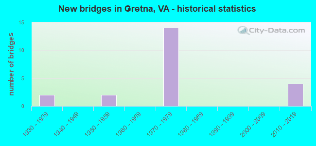
- New bridges - historical statistics
- 21930-1939
- 21950-1959
- 141970-1979
- 42010-2019

- Reconstructed bridges - Historical Statistics
- 11980-1989
- 01990-1999
- 02000-2009
- 12010-2019


- Bridge Condition - Deck
- 27.3%Very good
- 36.4%Good
- 36.4%Satisfactory

- Bridge Condition - Superstructure
- 27.3%Very good
- 18.2%Good
- 45.5%Satisfactory
- 9.1%Fair

- Bridge Condition - Substructure
- 9.1%Very good
- 27.3%Good
- 54.5%Satisfactory
- 9.1%Fair

- Bridge Condition - Channel
- 63.6%Good
- 36.4%Satisfactory

- Bridge Condition - Culverts
- 28.6%Very good
- 14.3%Good
- 42.9%Satisfactory
- 14.3%Poor
Find on map >> Show street view
Structure Number: 1343, Location: 0.00 TO 922- 0.01 TO 1080 (Lat: 36.911467, Lng: -79.387561), Route carried "on" structure: Bypass US 29, Year Built: 1956, Status: Open, Structure Length: 0.84m (2.76ft), Average Daily Traffic: 17,298 (year 2020), Truck Traffic: 15%, Average Future Daily Traffic: 22,657 (year 2040), Features Intersected: Br Whitethorn Creek
Minimum Vertical Clearance: 30+ m (98+ ft), Kilometerpoint: 51.343, Lanes on structure: 4, Base Highway Network: Yes, Owner: State Highway Agency, Approaching Roadway Width: 33.5m (109.9ft), Skew: 3 degrees, Material/Design: Concrete, Design/Construction: Culvert, Number Of Spans In Main Unit: 3, Length of Maximum Span: 2.6m (8.5ft)
Condition: Channel: Satisfactory, Culverts: Satisfactory, Operating Rating: 89.8 metric tons, Method Used To Determine Operating Rating: Load Factor (LF), Inventory Rating: 89.8 metric tons, Method Used To Determine Inventory Rating: Load Factor (LF), Structural Evaluation: Equal to present minimum criteria, Waterway Adequacy: Equal to present desirable criteria, Approach Roadway Alignment: Equal to present desirable criteria, Designated Inspection Frequency: Every 24 months, Inspection Date: October 2021
Find on map >> Show street view
Structure Number: 13433, Location: 0.50 TO 672 - 2.05 TO 40 (Lat: 36.924539, Lng: -79.376664), Route carried "on" structure: Bypass US 29, Year Built: 1974, Status: Open, Structure Length: 0.64m (2.10ft), Average Daily Traffic: 8,649 (year 2020), Truck Traffic: 15%, Average Future Daily Traffic: 12,109 (year 2040), Features Intersected: Whitethorn Creek
Minimum Vertical Clearance: 30+ m (98+ ft), Kilometerpoint: 53.136, Lanes on structure: 2, Base Highway Network: Yes, Owner: State Highway Agency, Approaching Roadway Width: 9.1m (29.9ft), Material/Design: Concrete, Design/Construction: Culvert, Number Of Spans In Main Unit: 2, Length of Maximum Span: 3.1m (10.2ft)
Condition: Channel: Satisfactory, Culverts: Satisfactory, Operating Rating: 89.8 metric tons, Method Used To Determine Operating Rating: Load Factor (LF), Inventory Rating: 89.8 metric tons, Method Used To Determine Inventory Rating: Load Factor (LF), Structural Evaluation: Equal to present minimum criteria, Waterway Adequacy: Equal to present desirable criteria, Approach Roadway Alignment: Equal to present desirable criteria, Designated Inspection Frequency: Every 24 months, Inspection Date: September 2021
Find on map >> Show street view
Structure Number: 13436, Location: 0.60 TO 29 - 0.60 TO 676 (Lat: 36.933553, Lng: -79.368719), Route carried "on" structure: Business US 29, Year Built: 1957, Status: Open, Structure Length: 0.72m (2.36ft), Average Daily Traffic: 2,074 (year 2020), Truck Traffic: 2%, Average Future Daily Traffic: 2,904 (year 2040), Design Load: HS 20, Features Intersected: Br. of Whitethorn Creek, Facility Carried by Structure: Main Street
Minimum Vertical Clearance: 30+ m (98+ ft), Kilometerpoint: 51.182, Lanes on structure: 2, Base Highway Network: Yes, Owner: State Highway Agency, Approaching Roadway Width: 7.3m (24.0ft), Skew: 4 degrees, Material/Design: Concrete, Design/Construction: Culvert, Number Of Spans In Main Unit: 2, Length of Maximum Span: 3.4m (11.2ft)
Condition: Channel: Good, Culverts: Good, Operating Rating: 89.8 metric tons, Method Used To Determine Operating Rating: Load Factor (LF), Inventory Rating: 57.2 metric tons, Method Used To Determine Inventory Rating: Load Factor (LF), Structural Evaluation: Better than present minimum criteria, Waterway Adequacy: Equal to present minimum criteria, Approach Roadway Alignment: Equal to present desirable criteria, Designated Inspection Frequency: Every 24 months, Inspection Date: September 2021
Find on map >> Show street view
Structure Number: 13453, Location: 1.48 to 29 - 0.35 to 40 (Lat: 36.948911, Lng: -79.378203), Route carried "on" structure: Bypass US 29, Year Built: 1974, Status: Open, Structure Length: 0.66m (2.17ft), Average Daily Traffic: 17,298 (year 2020), Truck Traffic: 15%, Average Future Daily Traffic: 22,657 (year 2040), Features Intersected: Br. Whitethorn Creek
Minimum Vertical Clearance: 30+ m (98+ ft), Kilometerpoint: 55.881, Lanes on structure: 4, Base Highway Network: Yes, Owner: State Highway Agency, Approaching Roadway Width: 9.8m (32.2ft), Skew: 4 degrees, Material/Design: Concrete, Design/Construction: Culvert, Number Of Spans In Main Unit: 2, Length of Maximum Span: 3.2m (10.5ft)
Condition: Channel: Good, Culverts: Satisfactory, Operating Rating: 89.8 metric tons, Method Used To Determine Operating Rating: Load Factor (LF), Inventory Rating: 89.8 metric tons, Method Used To Determine Inventory Rating: Load Factor (LF), Structural Evaluation: Equal to present minimum criteria, Waterway Adequacy: Equal to present desirable criteria, Approach Roadway Alignment: Equal to present desirable criteria, Designated Inspection Frequency: Every 24 months, Inspection Date: September 2021
Find on map >> Show street view
Structure Number: 1346, Location: 0.14-Rt 29 /1.23-NCL Gret (Lat: 36.976264, Lng: -79.354522), Route carried "on" structure: Ramp US 29, Year Built: 1974, Status: Open, Structure Length: 8.87m (29.10ft), Average Daily Traffic: 2,042 (year 2020), Truck Traffic: 2%, Average Future Daily Traffic: 2,859 (year 2040), Design Load: HS 20+Mod, Features Intersected: NBL Rt 29 BP-Gretna BP
Minimum Vertical Clearance: 30+ m (98+ ft), Kilometerpoint: 56.299, Lanes on structure: 1, Lanes under structure: 2, Base Highway Network: Yes, Owner: State Highway Agency, Approaching Roadway Width: 12.8m (42.0ft), Skew: 5 degrees, Material/Design: Steel, Design/Construction: Stringer/Multi-beam, Number Of Spans In Main Unit: 3, Length of Maximum Span: 45.2m (148.3ft), Curb-To-Curb Width: 8.5m (27.9ft), Out-to-Out Width: 9.8m (32.2ft)
Condition: Deck: Good, Superstructure: Good, Substructure: Satisfactory, Operating Rating: 69.9 metric tons, Method Used To Determine Operating Rating: Load and Resistance Factor (LRFR), Inventory Rating: 53.5 metric tons, Method Used To Determine Inventory Rating: Load and Resistance Factor (LRFR), Structural Evaluation: Equal to present minimum criteria, Deck Geometry: Superior to present desirable criteria, Underclear: Better than present minimum criteria, Approach Roadway Alignment: Equal to present desirable criteria, Designated Inspection Frequency: Every 24 months, Inspection Date: June 2020, Deck Structure Type: Concrete Cast-file-Place, Wearing Surface/Protective System: Wearing Surface: Latex Concrete
Find on map >> Show street view
Structure Number: 13462, Location: 1.80-Rt 40 / 0.75-Rt 672 (Lat: 36.927289, Lng: -79.375347), Route carried "on" structure: Bypass US 29, Year Built: 1974, Status: Open, Structure Length: 5.73m (18.80ft), Average Daily Traffic: 8,649 (year 2020), Truck Traffic: 13%, Average Future Daily Traffic: 12,109 (year 2040), Design Load: HS 20+Mod, Features Intersected: Rt 29 SBL Business
Minimum Vertical Clearance: 30+ m (98+ ft), Kilometerpoint: 53.499, Lanes on structure: 2, Lanes under structure: 2, Base Highway Network: Yes, Owner: State Highway Agency, Approaching Roadway Width: 19.5m (64.0ft), Skew: 5 degrees, Material/Design: Steel, Design/Construction: Stringer/Multi-beam, Number Of Spans In Main Unit: 3, Length of Maximum Span: 36.9m (121.1ft), Curb-To-Curb Width: 11.5m (37.7ft), Out-to-Out Width: 13.4m (44.0ft)
Condition: Deck: Good, Superstructure: Satisfactory, Substructure: Good, Operating Rating: 74.4 metric tons, Method Used To Determine Operating Rating: Load and Resistance Factor (LRFR), Inventory Rating: 57.2 metric tons, Method Used To Determine Inventory Rating: Load and Resistance Factor (LRFR), Structural Evaluation: Equal to present minimum criteria, Deck Geometry: Equal to present minimum criteria, Underclear: Equal to present minimum criteria, Approach Roadway Alignment: Equal to present desirable criteria, Designated Inspection Frequency: Every 24 months, Inspection Date: June 2020, Deck Structure Type: Concrete Cast-file-Place, Wearing Surface/Protective System: Wearing Surface: Latex Concrete
Find on map >> Show street view
Structure Number: 1347, Location: 1.00 TO 674 - 0.01 TO 917 (Lat: 36.936389, Lng: -79.311461), Route carried "on" structure: State highway 40, Year Built: 1932, Status: Open, Structure Length: 0.99m (3.25ft), Average Daily Traffic: 1,393 (year 2020), Truck Traffic: 11%, Average Future Daily Traffic: 1,532 (year 2040), Design Load: HS 20, Features Intersected: George's Creek, Facility Carried by Structure: Gretna Road
Minimum Vertical Clearance: 30+ m (98+ ft), Kilometerpoint: 109.628, Lanes on structure: 2, Base Highway Network: Yes, Owner: State Highway Agency, Approaching Roadway Width: 6.4m (21.0ft), Skew: 3 degrees, Material/Design: Concrete, Design/Construction: Tee Beam, Number Of Spans In Main Unit: 1, Length of Maximum Span: 8.4m (27.6ft), Curb or Sidewalk Widths: Left: 0.2m (0.7ft), Right: 0.2m (0.7ft), Curb-To-Curb Width: 6.9m (22.6ft), Out-to-Out Width: 7.7m (25.3ft)
Condition: Deck: Satisfactory, Superstructure: Satisfactory, Substructure: Satisfactory, Channel: Satisfactory, Operating Rating: 44.5 metric tons, Method Used To Determine Operating Rating: Load Factor (LF), Inventory Rating: 26.3 metric tons, Method Used To Determine Inventory Rating: Load Factor (LF), Structural Evaluation: Equal to present minimum criteria, Deck Geometry: High priority of corrective action, Waterway Adequacy: Equal to present minimum criteria, Approach Roadway Alignment: Equal to present desirable criteria, Length Of Structure Improvement: 1.68m (5.51ft), Designated Inspection Frequency: Every 24 months, Inspection Date: April 2021, Bridge Improvement Cost: $481,000, Roadway Improvement Cost: $48,000, Total Project Cost: $721,000, Deck Structure Type: Concrete Cast-file-Place, Wearing Surface/Protective System: Wearing Surface: Bituminous
Find on map >> Show street view
Structure Number: 13471, Location: 0.16-Rt29Bus/0.27-Gretna (Lat: 36.946625, Lng: -79.360328), Route carried "on" structure: State highway 40, Year Built: 1938, Year Reconstructed: 1991, Status: Open, Structure Length: 3.58m (11.75ft), Average Daily Traffic: 2,821 (year 2020), Truck Traffic: 15%, Average Future Daily Traffic: 3,103 (year 2040), Features Intersected: NS Railroad, Facility Carried by Structure: Gretna Road
Minimum Vertical Clearance: 30+ m (98+ ft), Kilometerpoint: 104.582, Lanes on structure: 2, Owner: State Highway Agency, Approaching Roadway Width: 7.0m (23.0ft), Material/Design: Concrete, Design/Construction: Tee Beam, Number Of Spans In Main Unit: 3, Length of Maximum Span: 12.2m (40.0ft), Curb or Sidewalk Widths: Left: 0.2m (0.7ft), Right: 0.2m (0.7ft), Curb-To-Curb Width: 7.3m (24.0ft), Out-to-Out Width: 8.0m (26.2ft)
Condition: Deck: Satisfactory, Superstructure: Fair, Substructure: Satisfactory, Operating Rating: 55.3 metric tons, Method Used To Determine Operating Rating: Load Factor (LF), Inventory Rating: 32.7 metric tons, Method Used To Determine Inventory Rating: Load Factor (LF), Structural Evaluation: Somewhat better than minimum adequacy, Deck Geometry: High priority of replacement, Underclear: Somewhat better than minimum adequacy, Approach Roadway Alignment: Equal to present desirable criteria, Length Of Structure Improvement: 3.60m (11.81ft), Designated Inspection Frequency: Every 24 months, Inspection Date: September 2021, Bridge Improvement Cost: $571,000, Roadway Improvement Cost: $57,000, Total Project Cost: $857,000 ( Estimate for 2015), Deck Structure Type: Concrete Cast-file-Place, Wearing Surface/Protective System: Wearing Surface: Bituminous
Find on map >> Show street view
Structure Number: 13484, Location: 0.73-Gretn/13.63-Frank Co (Lat: 36.953950, Lng: -79.379533), Route carried "on" structure: State highway 40, Year Built: 1974, Status: Open, Structure Length: 9.85m (32.32ft), Average Daily Traffic: 5,540 (year 2020), Truck Traffic: 13%, Average Future Daily Traffic: 7,756 (year 2040), Design Load: HS 20+Mod, Features Intersected: Rt 29 Bypass, Facility Carried by Structure: Gretna Road
Minimum Vertical Clearance: 30+ m (98+ ft), Kilometerpoint: 102.620, Lanes on structure: 2, Lanes under structure: 4, Base Highway Network: Yes, Owner: State Highway Agency, Approaching Roadway Width: 15.8m (51.8ft), Material/Design: Steel, Design/Construction: Stringer/Multi-beam, Number Of Spans In Main Unit: 5, Length of Maximum Span: 27.7m (90.9ft), Curb-To-Curb Width: 11.5m (37.7ft), Out-to-Out Width: 12.8m (42.0ft)
Condition: Deck: Good, Superstructure: Good, Substructure: Fair, Operating Rating: 72.6 metric tons, Method Used To Determine Operating Rating: Load and Resistance Factor (LRFR), Inventory Rating: 56.2 metric tons, Method Used To Determine Inventory Rating: Load and Resistance Factor (LRFR), Structural Evaluation: Somewhat better than minimum adequacy, Deck Geometry: Meets minimum limits, Underclear: Superior to present desirable criteria, Approach Roadway Alignment: Equal to present desirable criteria, Designated Inspection Frequency: Every 24 months, Inspection Date: June 2020, Deck Structure Type: Concrete Cast-file-Place, Wearing Surface/Protective System: Wearing Surface: Latex Concrete
Find on map >> Show street view
Structure Number: 13595, Location: 0.02-Rt. 29 / 0.51-Rt.634 (Lat: 36.984444, Lng: -79.354264), Route carried "on" structure: County highway 665, Year Built: 1978, Status: Open, Structure Length: 5.09m (16.70ft), Average Daily Traffic: 1,043 (year 2020), Truck Traffic: 3%, Average Future Daily Traffic: 1,147 (year 2040), Features Intersected: NS Railroad, Facility Carried by Structure: Rockford School Rd
Minimum Vertical Clearance: 30+ m (98+ ft), Kilometerpoint: 16.732, Lanes on structure: 2, Owner: State Highway Agency, Approaching Roadway Width: 6.4m (21.0ft), Material/Design: Steel, Design/Construction: Stringer/Multi-beam, Number Of Spans In Main Unit: 3, Length of Maximum Span: 15.7m (51.5ft), Curb-To-Curb Width: 7.9m (25.9ft), Out-to-Out Width: 9.1m (29.9ft)
Condition: Deck: Satisfactory, Superstructure: Satisfactory, Substructure: Good, Operating Rating: 78.0 metric tons, Method Used To Determine Operating Rating: Load and Resistance Factor (LRFR), Inventory Rating: 59.9 metric tons, Method Used To Determine Inventory Rating: Load and Resistance Factor (LRFR), Structural Evaluation: Equal to present minimum criteria, Deck Geometry: Meets minimum limits, Underclear: Better than present minimum criteria, Approach Roadway Alignment: Equal to present desirable criteria, Designated Inspection Frequency: Every 24 months, Inspection Date: September 2021, Deck Structure Type: Concrete Cast-file-Place
Find on map >> Show street view
Structure Number: 13697, Location: 1.40-Rt.790/0.55-Gretna (Lat: 36.965472, Lng: -79.367136), Route carried "on" structure: County highway 760, Year Built: 1974, Status: Open, Structure Length: 11.50m (37.73ft), Average Daily Traffic: 593 (year 2015), Average Future Daily Traffic: 890 (year 2040), Design Load: HS 20+Mod, Features Intersected: Route 29 Bypass, Facility Carried by Structure: Music Street
Minimum Vertical Clearance: 30+ m (98+ ft), Kilometerpoint: 1.593, Lanes on structure: 2, Lanes under structure: 4, Owner: State Highway Agency, Approaching Roadway Width: 7.3m (24.0ft), Skew: 2 degrees, Material/Design: Steel, Design/Construction: Stringer/Multi-beam, Number Of Spans In Main Unit: 5, Length of Maximum Span: 28.6m (93.8ft), Curb-To-Curb Width: 8.1m (26.6ft), Out-to-Out Width: 9.3m (30.5ft)
Condition: Deck: Good, Superstructure: Satisfactory, Substructure: Satisfactory, Operating Rating: 66.2 metric tons, Method Used To Determine Operating Rating: Load and Resistance Factor (LRFR), Inventory Rating: 50.8 metric tons, Method Used To Determine Inventory Rating: Load and Resistance Factor (LRFR), Structural Evaluation: Equal to present minimum criteria, Deck Geometry: Somewhat better than minimum adequacy, Underclear: Better than present minimum criteria, Approach Roadway Alignment: Equal to present desirable criteria, Designated Inspection Frequency: Every 24 months, Inspection Date: January 2022, Deck Structure Type: Concrete Cast-file-Place, Wearing Surface/Protective System: Wearing Surface: Latex Concrete
Find on map >> Show street view
Structure Number: 13793, Location: 0.45-Rt.1080/0.16-Rt.687 (Lat: 36.904794, Lng: -79.382464), Route carried "on" structure: County highway 903, Year Built: 1970, Status: Open, Structure Length: 4.79m (15.72ft), Average Daily Traffic: 231 (year 2015), Average Future Daily Traffic: 260 (year 2040), Design Load: HS 20+Mod, Features Intersected: NS Railroad, Facility Carried by Structure: Galveston Road
Minimum Vertical Clearance: 30+ m (98+ ft), Kilometerpoint: 0.758, Lanes on structure: 2, Owner: State Highway Agency, Approaching Roadway Width: 6.1m (20.0ft), Skew: 3 degrees, Material/Design: Steel, Design/Construction: Stringer/Multi-beam, Number Of Spans In Main Unit: 3, Length of Maximum Span: 19.5m (64.0ft), Curb-To-Curb Width: 8.5m (27.9ft), Out-to-Out Width: 9.3m (30.5ft)
Condition: Deck: Satisfactory, Superstructure: Satisfactory, Substructure: Satisfactory, Operating Rating: 68.9 metric tons, Method Used To Determine Operating Rating: Load and Resistance Factor (LRFR), Inventory Rating: 53.5 metric tons, Method Used To Determine Inventory Rating: Load and Resistance Factor (LRFR), Structural Evaluation: Equal to present minimum criteria, Deck Geometry: Equal to present minimum criteria, Underclear: Equal to present minimum criteria, Approach Roadway Alignment: Equal to present desirable criteria, Designated Inspection Frequency: Every 24 months, Inspection Date: September 2021, Deck Structure Type: Concrete Cast-file-Place
Find on map >> Show street view
Structure Number: 13794, Location: 0.80 TO 687 - 1.50 TO 676 (Lat: 36.913894, Lng: -79.373125), Route carried "on" structure: County highway 903, Year Built: 1972, Year Reconstructed: 2017, Status: Open, Structure Length: 1.66m (5.45ft), Average Daily Traffic: 176 (year 2015), Average Future Daily Traffic: 198 (year 2040), Design Load: HL 93, Features Intersected: Whitethorn Creek, Facility Carried by Structure: Galveston Road
Minimum Vertical Clearance: 30+ m (98+ ft), Kilometerpoint: 2.333, Lanes on structure: 2, Owner: State Highway Agency, Approaching Roadway Width: 7.0m (23.0ft), Material/Design: Prestressed concrete, Design/Construction: Slab, Number Of Spans In Main Unit: 1, Length of Maximum Span: 14.6m (47.9ft), Curb-To-Curb Width: 7.2m (23.6ft), Out-to-Out Width: 7.3m (24.0ft)
Condition: Deck: Very good, Superstructure: Very good, Substructure: Satisfactory, Channel: Good, Operating Rating: 66.2 metric tons, Method Used To Determine Operating Rating: Load and Resistance Factor (LRFR), Inventory Rating: 49.0 metric tons, Method Used To Determine Inventory Rating: Load and Resistance Factor (LRFR), Structural Evaluation: Equal to present minimum criteria, Deck Geometry: Meets minimum limits, Waterway Adequacy: Better than present minimum criteria, Approach Roadway Alignment: Equal to present desirable criteria, Length Of Structure Improvement: 2.35m (7.71ft), Designated Inspection Frequency: Every 24 months, Inspection Date: April 2021, Bridge Improvement Cost: $410,000, Roadway Improvement Cost: $41,000, Total Project Cost: $614,000 ( Estimate for 2015), Deck Structure Type: Concrete Precast Panels, Wearing Surface/Protective System: Wearing Surface: Bituminous
Find on map >> Show street view
Structure Number: 2382, Location: 0.01 29BUS 0.30 WILLOW DR (Lat: 36.963131, Lng: -79.354839), Route carried "on" structure: County highway 1300, Year Built: 1975, Status: Open, Structure Length: 0.64m (2.10ft), Average Daily Traffic: 138 (year 2015), Average Future Daily Traffic: 207 (year 2040), Design Load: HS 20+Mod, Features Intersected: Georges Creek, Facility Carried by Structure: Knollwood Drive
Minimum Vertical Clearance: 30+ m (98+ ft), Kilometerpoint: 0.708, Lanes on structure: 2, Owner: State Highway Agency, Approaching Roadway Width: 6.1m (20.0ft), Material/Design: Steel, Design/Construction: Culvert, Number Of Spans In Main Unit: 2, Length of Maximum Span: 2.7m (8.9ft)
Condition: Channel: Satisfactory, Culverts: Poor, Operating Rating: 44.5 metric tons, Method Used To Determine Operating Rating: Field evaluation and documented engineering judgment, Inventory Rating: 32.7 metric tons, Method Used To Determine Inventory Rating: Field evaluation and documented engineering judgment, Structural Evaluation: Meets minimum limits, Waterway Adequacy: Better than present minimum criteria, Approach Roadway Alignment: Equal to present desirable criteria, Length Of Structure Improvement: 0.64m (2.10ft), Designated Inspection Frequency: Every 12 months, Inspection Date: September 2021, Bridge Improvement Cost: $252,000, Roadway Improvement Cost: $25,000, Total Project Cost: $378,000
Find on map >> Show street view
Structure Number: 2959, Location: 1.05 to 1069- 0.60 to 689 (Lat: 36.895447, Lng: -79.343519), Route carried "on" structure: County highway 676, Year Built: 2015, Status: Open, Structure Length: 5.70m (18.70ft), Average Daily Traffic: 358 (year 2015), Average Future Daily Traffic: 403 (year 2040), Design Load: HL 93, Features Intersected: Whitethorn Creek, Facility Carried by Structure: Taylors Mill Road
Minimum Vertical Clearance: 30+ m (98+ ft), Kilometerpoint: 0.000, Lanes on structure: 2, Owner: State Highway Agency, Approaching Roadway Width: 6.1m (20.0ft), Skew: 3 degrees, Material/Design: Steel continuous, Design/Construction: Stringer/Multi-beam, Number Of Spans In Main Unit: 2, Length of Maximum Span: 25.9m (85.0ft), Curb-To-Curb Width: 7.3m (24.0ft), Out-to-Out Width: 7.8m (25.6ft)
Condition: Deck: Very good, Superstructure: Very good, Substructure: Very good, Channel: Good, Operating Rating: 87.1 metric tons, Method Used To Determine Operating Rating: Load and Resistance Factor (LRFR), Inventory Rating: 67.1 metric tons, Method Used To Determine Inventory Rating: Load and Resistance Factor (LRFR), Structural Evaluation: Equal to present desirable criteria, Deck Geometry: Somewhat better than minimum adequacy, Waterway Adequacy: Equal to present minimum criteria, Approach Roadway Alignment: Equal to present desirable criteria, Designated Inspection Frequency: Every 24 months, Inspection Date: September 2021, Deck Structure Type: Concrete Cast-file-Place, Wearing Surface/Protective System: Wearing Surface: Monolithic Concrete, Deck Protection: Other Coated Reinforcing
Find on map >> Show street view
Structure Number: 30088, Location: 1.00 to 665 - 0.70 to 40 (Lat: 36.944319, Lng: -79.334700), Route carried "on" structure: County highway 673, Year Built: 2013, Status: Open, Structure Length: 1.14m (3.74ft), Average Daily Traffic: 164 (year 2015), Average Future Daily Traffic: 229 (year 2040), Design Load: HL 93, Features Intersected: Georges Creek, Facility Carried by Structure: Ben Annie Road
Minimum Vertical Clearance: 30+ m (98+ ft), Kilometerpoint: 0.000, Lanes on structure: 2, Owner: State Highway Agency, Approaching Roadway Width: 6.7m (22.0ft), Skew: 3 degrees, Material/Design: Concrete, Design/Construction: Frame, Number Of Spans In Main Unit: 1, Length of Maximum Span: 10.7m (35.1ft), Curb-To-Curb Width: 6.8m (22.3ft), Out-to-Out Width: 6.9m (22.6ft)
Condition: Deck: Very good, Superstructure: Very good, Substructure: Good, Channel: Good, Operating Rating: 64.4 metric tons, Method Used To Determine Operating Rating: Load and Resistance Factor (LRFR), Inventory Rating: 49.9 metric tons, Method Used To Determine Inventory Rating: Load and Resistance Factor (LRFR), Structural Evaluation: Better than present minimum criteria, Deck Geometry: Meets minimum limits, Waterway Adequacy: Equal to present minimum criteria, Approach Roadway Alignment: Equal to present desirable criteria, Designated Inspection Frequency: Every 24 months, Inspection Date: December 2020, Deck Structure Type: Concrete Precast Panels, Wearing Surface/Protective System: Wearing Surface: Bituminous
Find on map >> Show street view
Structure Number: 3078, Location: 0.60 TO 671-1.50 TO 665 (Lat: 36.962219, Lng: -79.307219), Route carried "on" structure: County highway 792, Year Built: 2016, Status: Open, Structure Length: 0.89m (2.92ft), Average Daily Traffic: 186 (year 2018), Average Future Daily Traffic: 206 (year 2040), Features Intersected: Stinking River
Minimum Vertical Clearance: 30+ m (98+ ft), Kilometerpoint: 6.460, Lanes on structure: 2, Base Highway Network: Yes, Owner: State Highway Agency, Approaching Roadway Width: 5.8m (19.0ft), Material/Design: Aluminum, Iron, Design/Construction: Culvert, Number Of Spans In Main Unit: 2, Length of Maximum Span: 4.0m (13.1ft)
Condition: Channel: Good, Culverts: Very good, Operating Rating: 45.4 metric tons, Method Used To Determine Operating Rating: Load Factor (LF), Inventory Rating: 26.3 metric tons, Method Used To Determine Inventory Rating: Load Factor (LF), Structural Evaluation: Equal to present minimum criteria, Waterway Adequacy: Better than present minimum criteria, Approach Roadway Alignment: Equal to present desirable criteria, Designated Inspection Frequency: Every 24 months, Inspection Date: September 2020
Find on map >> Show street view
Structure Number: 30781, Location: 1.13 TO 671 - 0.97 TO665 (Lat: 36.959964, Lng: -79.314461), Route carried "on" structure: County highway 792, Year Built: 2016, Status: Open, Structure Length: 0.90m (2.95ft), Average Daily Traffic: 186 (year 2018), Average Future Daily Traffic: 206 (year 2040), Features Intersected: W. Fork Stinking River, Facility Carried by Structure: Tucker Road
Minimum Vertical Clearance: 30+ m (98+ ft), Kilometerpoint: 5.607, Lanes on structure: 2, Base Highway Network: Yes, Owner: State Highway Agency, Approaching Roadway Width: 6.1m (20.0ft), Material/Design: Aluminum, Iron, Design/Construction: Culvert, Number Of Spans In Main Unit: 2, Length of Maximum Span: 4.0m (13.1ft)
Condition: Channel: Good, Culverts: Very good, Operating Rating: 49.9 metric tons, Method Used To Determine Operating Rating: Field evaluation and documented engineering judgment, Inventory Rating: 29.9 metric tons, Method Used To Determine Inventory Rating: Field evaluation and documented engineering judgment, Structural Evaluation: Better than present minimum criteria, Waterway Adequacy: Better than present minimum criteria, Approach Roadway Alignment: Equal to present desirable criteria, Designated Inspection Frequency: Every 24 months, Inspection Date: November 2020
Find on map >> Show street view
Structure Number: 1346, Location: 0.14-Rt 29 /1.23-NCL Gret (Lat: 36.976264, Lng: -79.354522), Route carried "under" structure: Bypass US 29, Year Built: 1974, Structure Length: 0. m, Average Daily Traffic: 9,750 (year 2019), Truck Traffic: 16%, Features Intersected: NBL Rt 29 BP-Gretna BP
Minimum Vertical Clearance: 5.54m (18.18ft), Kilometerpoint: 59.807, Lanes on structure: 1, Lanes under structure: 2, Material/Design: Steel, Design/Construction: Stringer/Multi-beam, Length of Maximum Span: 45.2m (148.3ft)
Find on map >> Show street view
Structure Number: 13462, Location: 1.80-Rt 40 / 0.75-Rt 672 (Lat: 36.927289, Lng: -79.375347), Route carried "under" structure: Business US 29, Year Built: 1974, Structure Length: 0. m, Average Daily Traffic: 4,700 (year 2019), Truck Traffic: 2%, Features Intersected: Rt 29 SBL Business
Minimum Vertical Clearance: 5.18m (16.99ft), Kilometerpoint: 0.000, Lanes on structure: 2, Lanes under structure: 2, Material/Design: Steel, Design/Construction: Stringer/Multi-beam, Length of Maximum Span: 36.9m (121.1ft)
Find on map >> Show street view
Structure Number: 13484, Location: 0.73-Gretn/13.63-Frank Co (Lat: 36.953950, Lng: -79.379533), Route carried "under" structure: Bypass US 29, Year Built: 1974, Structure Length: 0. m, Average Daily Traffic: 13,000 (year 2019), Truck Traffic: 13%, Features Intersected: Rt 29 Bypass, Facility Carried by Structure: Gretna Road
Minimum Vertical Clearance: 5.23m (17.16ft), Kilometerpoint: 56.444, Lanes on structure: 2, Lanes under structure: 4, Material/Design: Steel, Design/Construction: Stringer/Multi-beam, Length of Maximum Span: 27.7m (90.9ft)
Find on map >> Show street view
Structure Number: 13697, Location: 1.40-Rt.790/0.55-Gretna (Lat: 36.965472, Lng: -79.367136), Route carried "under" structure: Bypass US 29, Year Built: 1974, Structure Length: 0. m, Average Daily Traffic: 9,555 (year 2008), Truck Traffic: 16%, Features Intersected: Route 29 Bypass, Facility Carried by Structure: Music Street
Minimum Vertical Clearance: 5.16m (16.93ft), Kilometerpoint: 58.149, Lanes on structure: 2, Lanes under structure: 4, Material/Design: Steel, Design/Construction: Stringer/Multi-beam, Length of Maximum Span: 28.6m (93.8ft)