Bridge Statistics for Hardtner, Kansas (KS)
Condition, Traffic, Stress, Structural Evaluation, Project Costs
- National Bridge Inventory (NBI) Statistics
- 16Number of bridges
- 85ft / 26.4mTotal length
- $1,510,000Total costs
- 9,453Total average daily traffic
- 1,106Total average daily truck traffic
- 12,484Total future (year 2036) average daily traffic
- National Bridge Inventory (NBI) Registered Bridges for Hardtner
- No street view available for this location
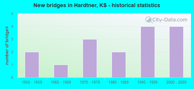
- New bridges - historical statistics
- 21950-1959
- 11960-1969
- 31970-1979
- 21980-1989
- 41990-1999
- 42000-2009


- Bridge Condition - Deck
- 14.3%Very good
- 57.1%Good
- 28.6%Satisfactory

- Bridge Condition - Superstructure
- 42.9%Good
- 57.1%Satisfactory

- Bridge Condition - Substructure
- 28.6%Good
- 42.9%Satisfactory
- 14.3%Fair
- 14.3%Poor

- Bridge Condition - Channel
- 6.3%Very good
- 31.3%Good
- 56.3%Satisfactory
- 6.3%Fair

- Bridge Condition - Culverts
- 66.7%Good
- 22.2%Fair
- 11.1%Poor
Find on map >> Show street view
Structure Number: 4005, Location: 3.0W OF HARDTNER (Lat: 37.013986, Lng: -98.707389), Route carried "on" structure: County highway 30, Year Built: 1972, Status: Open, Structure Length: 0.95m (3.12ft), Average Daily Traffic: 98 (year 2018), Truck Traffic: 10%, Average Future Daily Traffic: 595 (year 2041), Design Load: H 15, Features Intersected: TRIB. TO DRIFTWOOD CREEK, Facility Carried by Structure: Hackberry Road
Minimum Vertical Clearance: 30.47m (99.97ft), Kilometerpoint: 0.000, Lanes on structure: 2, Owner: County Highway Agency, Approaching Roadway Width: 6.6m (21.7ft), Material/Design: Concrete, Design/Construction: Culvert, Number Of Spans In Main Unit: 3, Length of Maximum Span: 3.0m (9.8ft), Curb or Sidewalk Widths: Left: 0.3m (1.0ft), Right: 0.3m (1.0ft), Curb-To-Curb Width: 8.5m (27.9ft), Out-to-Out Width: 9.1m (29.9ft)
Condition: Channel: Good, Culverts: Good, Operating Rating: 24.1 metric tons, Method Used To Determine Operating Rating: Load Factor (LF), Inventory Rating: 14.4 metric tons, Method Used To Determine Inventory Rating: Load Factor (LF), Structural Evaluation: Meets minimum limits, Deck Geometry: Better than present minimum criteria, Waterway Adequacy: Equal to present minimum criteria, Approach Roadway Alignment: Better than present minimum criteria, Designated Inspection Frequency: Every 24 months, Inspection Date: October 2021, Wearing Surface/Protective System: Wearing Surface: Bituminous
Find on map >> Show street view
Structure Number: 4006, Location: 0.5W OF HARDTNER (Lat: 37.013861, Lng: -98.658972), Route carried "on" structure: County highway 30, Year Built: 1951, Status: Posted for load, Structure Length: 4.97m (16.31ft), Average Daily Traffic: 128 (year 2018), Truck Traffic: 10%, Average Future Daily Traffic: 295 (year 2041), Features Intersected: DRIFTWOOD CREEK
Minimum Vertical Clearance: 30.47m (99.97ft), Kilometerpoint: 0.000, Lanes on structure: 2, Owner: County Highway Agency, Approaching Roadway Width: 6.4m (21.0ft), Material/Design: Steel continuous, Design/Construction: Stringer/Multi-beam, Number Of Spans In Main Unit: 4, Length of Maximum Span: 13.7m (44.9ft), Curb-To-Curb Width: 7.3m (24.0ft), Out-to-Out Width: 8.0m (26.2ft)
Condition: Deck: Good, Superstructure: Good, Substructure: Satisfactory, Channel: Satisfactory, Operating Rating: 9.0 metric tons, Method Used To Determine Operating Rating: Load Factor (LF), Inventory Rating: 5.4 metric tons, Method Used To Determine Inventory Rating: Load Factor (LF), Structural Evaluation: High priority of replacement, Deck Geometry: Somewhat better than minimum adequacy, Waterway Adequacy: Equal to present desirable criteria, Approach Roadway Alignment: Better than present minimum criteria, Bridge Posting: Required (Relationship of Operating Rating to Maximum Legal Load: > 39.9% below), Length Of Structure Improvement: 5.49m (18.01ft), Designated Inspection Frequency: Every 24 months, Inspection Date: October 2021, Bridge Improvement Cost: $660,000, Roadway Improvement Cost: $240,000, Total Project Cost: $900,000 ( Estimate for 2021), Deck Structure Type: Concrete Cast-file-Place, Wearing Surface/Protective System: Wearing Surface: Bituminous
Find on map >> Show street view
Structure Number: 4007, Location: 1.8N 2.5W OF HARDTNER (Lat: 37.038861, Lng: -98.694250), Route carried "on" structure: County highway 31, Year Built: 1983, Status: Posted for load, Structure Length: 4.05m (13.29ft), Average Daily Traffic: 170 (year 2018), Truck Traffic: 10%, Average Future Daily Traffic: 140 (year 2041), Design Load: HS 20, Features Intersected: DRIFTWOOD CREEK, Facility Carried by Structure: Gyp Hills Road
Minimum Vertical Clearance: 30.47m (99.97ft), Kilometerpoint: 0.000, Lanes on structure: 2, Owner: County Highway Agency, Approaching Roadway Width: 6.7m (22.0ft), Skew: 3 degrees, Material/Design: Concrete continuous, Design/Construction: Slab, Number Of Spans In Main Unit: 3, Length of Maximum Span: 15.8m (51.8ft), Curb-To-Curb Width: 8.5m (27.9ft), Out-to-Out Width: 9.1m (29.9ft)
Condition: Deck: Good, Superstructure: Good, Substructure: Good, Channel: Satisfactory, Operating Rating: 35.7 metric tons, Method Used To Determine Operating Rating: Load Factor (LF), Inventory Rating: 21.3 metric tons, Method Used To Determine Inventory Rating: Load Factor (LF), Structural Evaluation: Equal to present minimum criteria, Deck Geometry: Equal to present minimum criteria, Waterway Adequacy: Equal to present desirable criteria, Approach Roadway Alignment: Better than present minimum criteria, Bridge Posting: Required (Relationship of Operating Rating to Maximum Legal Load: 10.0 - 19.9% below), Designated Inspection Frequency: Every 24 months, Inspection Date: October 2021, Deck Structure Type: Concrete Cast-file-Place
Find on map >> Show street view
Structure Number: 4008, Location: 2.5W 2.5 N OF HARDTNER (Lat: 37.049000, Lng: -98.694361), Route carried "on" structure: County highway 31, Year Built: 1990, Status: Posted for load, Structure Length: 2.09m (6.86ft), Average Daily Traffic: 170 (year 2018), Truck Traffic: 10%, Average Future Daily Traffic: 140 (year 2041), Design Load: HS 20, Features Intersected: TRIB. TO DRIFTWOOD CREEK, Facility Carried by Structure: Gyp Hill Road
Minimum Vertical Clearance: 30.47m (99.97ft), Kilometerpoint: 0.000, Lanes on structure: 2, Owner: County Highway Agency, Approaching Roadway Width: 6.7m (22.0ft), Material/Design: Concrete, Design/Construction: Culvert, Number Of Spans In Main Unit: 8, Length of Maximum Span: 2.4m (7.9ft), Curb-To-Curb Width: 9.8m (32.2ft), Out-to-Out Width: 10.2m (33.5ft)
Condition: Channel: Good, Culverts: Good, Operating Rating: 33.7 metric tons, Method Used To Determine Operating Rating: Load Factor (LF), Inventory Rating: 20.2 metric tons, Method Used To Determine Inventory Rating: Load Factor (LF), Structural Evaluation: Somewhat better than minimum adequacy, Deck Geometry: Better than present minimum criteria, Waterway Adequacy: Equal to present desirable criteria, Approach Roadway Alignment: Better than present minimum criteria, Bridge Posting: Required (Relationship of Operating Rating to Maximum Legal Load: 0.1 - 9.9% below), Designated Inspection Frequency: Every 24 months, Inspection Date: October 2021, Wearing Surface/Protective System: Wearing Surface: Gravel
Find on map >> Show street view
Structure Number: 87057, Location: 4.0E 3.2S OF KECHI (Lat: 37.749650, Lng: -97.208172), Route carried "on" structure: County highway 309, Year Built: 1960, Status: Open, Structure Length: 0.85m (2.79ft), Average Daily Traffic: 3,744 (year 2018), Truck Traffic: 5%, Average Future Daily Traffic: 4,568 (year 2038), Features Intersected: DRY CREEK
Minimum Vertical Clearance: 30.47m (99.97ft), Kilometerpoint: 0.000, Lanes on structure: 2, Owner: County Highway Agency, Approaching Roadway Width: 13.1m (43.0ft), Material/Design: Concrete, Design/Construction: Culvert, Number Of Spans In Main Unit: 3, Length of Maximum Span: 2.7m (8.9ft), Curb-To-Curb Width: 13.5m (44.3ft), Out-to-Out Width: 14.1m (46.3ft)
Condition: Channel: Good, Culverts: Fair, Operating Rating: 22.5 metric tons, Method Used To Determine Operating Rating: Load Factor (LF), Inventory Rating: 17.1 metric tons, Method Used To Determine Inventory Rating: Load Factor (LF), Structural Evaluation: Meets minimum limits, Deck Geometry: Superior to present desirable criteria, Waterway Adequacy: Better than present minimum criteria, Approach Roadway Alignment: Equal to present desirable criteria, Designated Inspection Frequency: Every 24 months, Inspection Date: November 2021, Deck Structure Type: Other, Wearing Surface/Protective System: Wearing Surface: Bituminous
Find on map >> Show street view
Structure Number: 87058, Location: 1.5E OF MULVANE (Lat: 37.483281, Lng: -97.208153), Route carried "on" structure: County highway 309, Year Built: 1976, Status: Posted for load, Structure Length: 1.34m (4.40ft), Average Daily Traffic: 734 (year 2018), Truck Traffic: 5%, Average Future Daily Traffic: 895 (year 2038), Design Load: H 20, Features Intersected: DOG CREEK
Minimum Vertical Clearance: 30.47m (99.97ft), Kilometerpoint: 0.000, Lanes on structure: 2, Owner: County Highway Agency, Approaching Roadway Width: 8.8m (28.9ft), Material/Design: Concrete, Design/Construction: Culvert, Number Of Spans In Main Unit: 4, Length of Maximum Span: 3.4m (11.2ft), Curb-To-Curb Width: 11.0m (36.1ft), Out-to-Out Width: 11.6m (38.1ft)
Condition: Channel: Satisfactory, Culverts: Fair, Operating Rating: 35.4 metric tons, Method Used To Determine Operating Rating: Load Factor (LF), Inventory Rating: 21.2 metric tons, Method Used To Determine Inventory Rating: Load Factor (LF), Structural Evaluation: Somewhat better than minimum adequacy, Deck Geometry: Better than present minimum criteria, Waterway Adequacy: Equal to present minimum criteria, Approach Roadway Alignment: Equal to present desirable criteria, Length Of Structure Improvement: 1.52m (4.99ft), Designated Inspection Frequency: Every 24 months, Inspection Date: September 2020, Bridge Improvement Cost: $50,000, Roadway Improvement Cost: $10,000, Total Project Cost: $60,000 ( Estimate for 2020), Deck Structure Type: Concrete Cast-file-Place, Wearing Surface/Protective System: Wearing Surface: Bituminous
Find on map >> Show street view
Structure Number: 8706, Location: 125thN, 0.9 E of Meridian (Lat: 37.912194, Lng: -97.356500), Route carried "on" structure: County highway 307, Year Built: 2006, Status: Open, Structure Length: 0.77m (2.53ft), Average Daily Traffic: 1,865 (year 2018), Truck Traffic: 5%, Average Future Daily Traffic: 2,276 (year 2038), Design Load: HS 20, Features Intersected: TRIB. TO JESTER CREEK
Minimum Vertical Clearance: 30.47m (99.97ft), Kilometerpoint: 0.000, Lanes on structure: 2, Owner: County Highway Agency, Approaching Roadway Width: 7.3m (24.0ft), Material/Design: Concrete, Design/Construction: Culvert, Number Of Spans In Main Unit: 3, Length of Maximum Span: 2.4m (7.9ft), Curb-To-Curb Width: 14.0m (45.9ft), Out-to-Out Width: 14.4m (47.2ft)
Condition: Channel: Very good, Culverts: Good, Operating Rating: 61.7 metric tons, Method Used To Determine Operating Rating: Load Factor (LF), Inventory Rating: 36.9 metric tons, Method Used To Determine Inventory Rating: Load Factor (LF), Structural Evaluation: Better than present minimum criteria, Deck Geometry: Superior to present desirable criteria, Waterway Adequacy: Equal to present desirable criteria, Approach Roadway Alignment: Equal to present desirable criteria, Designated Inspection Frequency: Every 24 months, Inspection Date: August 2021, Deck Structure Type: Concrete Cast-file-Place, Wearing Surface/Protective System: Wearing Surface: Bituminous
Find on map >> Show street view
Structure Number: 87065, Location: 117thN, 0.4 E of 199thW (Lat: 37.897814, Lng: -97.582728), Route carried "on" structure: County highway 610, Year Built: 1975, Status: Posted for load, Structure Length: 1.98m (6.50ft), Average Daily Traffic: 249 (year 2018), Truck Traffic: 5%, Average Future Daily Traffic: 304 (year 2038), Design Load: H 20, Features Intersected: MAIN EAGLE DRAIN DITCH
Minimum Vertical Clearance: 30.47m (99.97ft), Kilometerpoint: 0.000, Lanes on structure: 2, Owner: County Highway Agency, Approaching Roadway Width: 9.1m (29.9ft), Material/Design: Concrete, Design/Construction: Culvert, Number Of Spans In Main Unit: 6, Length of Maximum Span: 3.4m (11.2ft), Curb-To-Curb Width: 10.9m (35.8ft), Out-to-Out Width: 11.6m (38.1ft)
Condition: Channel: Satisfactory, Culverts: Poor, Operating Rating: 23.0 metric tons, Method Used To Determine Operating Rating: Load Factor (LF), Inventory Rating: 13.8 metric tons, Method Used To Determine Inventory Rating: Load Factor (LF), Structural Evaluation: Meets minimum limits, Deck Geometry: Better than present minimum criteria, Waterway Adequacy: Equal to present minimum criteria, Approach Roadway Alignment: Equal to present desirable criteria, Bridge Posting: Required (Relationship of Operating Rating to Maximum Legal Load: 0.1 - 9.9% below), Length Of Structure Improvement: 9.14m (29.99ft), Designated Inspection Frequency: Every 24 months, Inspection Date: June 2021, Bridge Improvement Cost: $450,000, Roadway Improvement Cost: $100,000, Total Project Cost: $550,000 ( Estimate for 2018), Deck Structure Type: Concrete Cast-file-Place, Wearing Surface/Protective System: Wearing Surface: Bituminous
Find on map >> Show street view
Structure Number: 4066970714, Location: 13.5N 1.9W OF ALVA (Lat: 37.000000, Lng: -98.699450), Route carried "on" structure: Other road , Year Built: 1991, Status: Posted for load, Structure Length: 0.63m (2.07ft), Average Daily Traffic: 24 (year 2016), Truck Traffic: 5%, Average Future Daily Traffic: 38 (year 2036), Design Load: H 20, Features Intersected: CREEK, Facility Carried by Structure: Local Road
Minimum Vertical Clearance: 30.47m (99.97ft), Kilometerpoint: 0.000, Lanes on structure: 2, Owner: County Highway Agency, Approaching Roadway Width: 6.0m (19.7ft), Material/Design: Wood or Timber, Design/Construction: Stringer/Multi-beam, Number Of Spans In Main Unit: 1, Length of Maximum Span: 5.8m (19.0ft), Curb-To-Curb Width: 12.2m (40.0ft), Out-to-Out Width: 13.3m (43.6ft)
Condition: Deck: Satisfactory, Superstructure: Satisfactory, Substructure: Poor, Channel: Satisfactory, Operating Rating: 8.3 metric tons, Method Used To Determine Operating Rating: Allowable Stress (AS), Inventory Rating: 4.9 metric tons, Method Used To Determine Inventory Rating: Allowable Stress (AS), Structural Evaluation: High priority of corrective action, Deck Geometry: Superior to present desirable criteria, Waterway Adequacy: Equal to present minimum criteria, Approach Roadway Alignment: Equal to present desirable criteria, Bridge Posting: Required (Relationship of Operating Rating to Maximum Legal Load: > 39.9% below), Designated Inspection Frequency: Every 24 months, Inspection Date: January 2020, Deck Structure Type: Wood or Timber, Wearing Surface/Protective System: Wearing Surface: Gravel
Find on map >> Show street view
Structure Number: 4067150708, Location: 1.5N 2.0W OF HARDTNER (Lat: 37.035778, Lng: -98.685278), Route carried "on" structure: County highway , Year Built: 2006, Status: Open, Structure Length: 1.84m (6.04ft), Average Daily Traffic: 25 (year 2018), Truck Traffic: 5%, Average Future Daily Traffic: 25 (year 2041), Design Load: HS 20, Features Intersected: DRIFTWOOD CREEK, Facility Carried by Structure: Driftwood Road
Minimum Vertical Clearance: 30.47m (99.97ft), Kilometerpoint: 0.000, Lanes on structure: 2, Owner: County Highway Agency, Approaching Roadway Width: 6.7m (22.0ft), Skew: 3 degrees, Material/Design: Concrete, Design/Construction: Culvert, Number Of Spans In Main Unit: 5, Length of Maximum Span: 3.5m (11.5ft), Curb or Sidewalk Widths: Left: 0.2m (0.7ft), Right: 0.2m (0.7ft), Curb-To-Curb Width: 8.5m (27.9ft), Out-to-Out Width: 9.0m (29.5ft)
Condition: Channel: Satisfactory, Culverts: Good, Operating Rating: 69.5 metric tons, Method Used To Determine Operating Rating: Load Factor (LF), Inventory Rating: 41.5 metric tons, Method Used To Determine Inventory Rating: Load Factor (LF), Structural Evaluation: Better than present minimum criteria, Deck Geometry: Better than present minimum criteria, Waterway Adequacy: Somewhat better than minimum adequacy, Approach Roadway Alignment: Somewhat better than minimum adequacy, Designated Inspection Frequency: Every 24 months, Inspection Date: October 2021, Wearing Surface/Protective System: Wearing Surface: Gravel
Find on map >> Show street view
Structure Number: 40673707081, Location: 0.7W 1.4N OF HARDTNER (Lat: 37.033861, Lng: -98.662861), Route carried "on" structure: County highway , Year Built: 1956, Status: Posted for load, Structure Length: 1.46m (4.79ft), Average Daily Traffic: 30 (year 2018), Truck Traffic: 5%, Average Future Daily Traffic: 30 (year 2041), Features Intersected: TRIB. TO DRIFTWOOD CREEK, Facility Carried by Structure: Driftwood Road
Minimum Vertical Clearance: 30.47m (99.97ft), Kilometerpoint: 0.000, Lanes on structure: 2, Owner: County Highway Agency, Approaching Roadway Width: 6.7m (22.0ft), Skew: 2 degrees, Material/Design: Wood or Timber, Design/Construction: Stringer/Multi-beam, Number Of Spans In Main Unit: 3, Length of Maximum Span: 4.9m (16.1ft), Curb-To-Curb Width: 6.1m (20.0ft), Out-to-Out Width: 6.1m (20.0ft)
Condition: Deck: Good, Superstructure: Satisfactory, Substructure: Fair, Channel: Fair, Operating Rating: 20.0 metric tons, Method Used To Determine Operating Rating: Allowable Stress (AS), Inventory Rating: 13.7 metric tons, Method Used To Determine Inventory Rating: Allowable Stress (AS), Structural Evaluation: Meets minimum limits, Deck Geometry: Somewhat better than minimum adequacy, Waterway Adequacy: Equal to present minimum criteria, Approach Roadway Alignment: Equal to present minimum criteria, Bridge Posting: Required (Relationship of Operating Rating to Maximum Legal Load: 20.0 - 29.9% below), Designated Inspection Frequency: Every 24 months, Inspection Date: October 2021, Deck Structure Type: Corrugated Steel, Wearing Surface/Protective System: Wearing Surface: Gravel
Find on map >> Show street view
Structure Number: 4067390714, Location: 0.6W 1.0S OF HARDTNER (Lat: 36.998933, Lng: -98.659250), Route carried "on" structure: County highway , Year Built: 2009, Status: Open, Structure Length: 1.81m (5.94ft), Average Daily Traffic: 30 (year 2013), Truck Traffic: 5%, Average Future Daily Traffic: 30 (year 2037), Design Load: HS 20, Features Intersected: DRIFTWOOD CREEK, Facility Carried by Structure: State Line Road
Minimum Vertical Clearance: 30.47m (99.97ft), Kilometerpoint: 0.000, Lanes on structure: 2, Owner: County Highway Agency, Approaching Roadway Width: 6.7m (22.0ft), Skew: 3 degrees, Material/Design: Steel continuous, Design/Construction: Stringer/Multi-beam, Number Of Spans In Main Unit: 2, Length of Maximum Span: 8.9m (29.2ft), Curb-To-Curb Width: 7.7m (25.3ft), Out-to-Out Width: 7.9m (25.9ft)
Condition: Deck: Very good, Superstructure: Good, Substructure: Good, Channel: Good, Operating Rating: 88.6 metric tons, Method Used To Determine Operating Rating: Load Factor (LF), Inventory Rating: 52.6 metric tons, Method Used To Determine Inventory Rating: Load Factor (LF), Structural Evaluation: Better than present minimum criteria, Deck Geometry: Equal to present minimum criteria, Waterway Adequacy: Better than present minimum criteria, Approach Roadway Alignment: Better than present minimum criteria, Designated Inspection Frequency: Every 24 months, Inspection Date: November 2021, Deck Structure Type: Concrete Cast-file-Place, Wearing Surface/Protective System: Wearing Surface: Monolithic Concrete
Find on map >> Show street view
Structure Number: 40677007026, Location: 0.5E 4.0N OF HARDTNER (Lat: 37.070861, Lng: -98.640492), Route carried "on" structure: County highway , Year Built: 2000, Status: Open, Structure Length: 0.98m (3.22ft), Average Daily Traffic: 50 (year 2018), Truck Traffic: 5%, Average Future Daily Traffic: 50 (year 2041), Features Intersected: LITTLE DRIFTWOOD CREEK, Facility Carried by Structure: Hartner Shortcut
Minimum Vertical Clearance: 30.47m (99.97ft), Kilometerpoint: 0.000, Lanes on structure: 2, Owner: County Highway Agency, Approaching Roadway Width: 6.2m (20.3ft), Material/Design: Steel, Design/Construction: Stringer/Multi-beam, Number Of Spans In Main Unit: 1, Length of Maximum Span: 9.4m (30.8ft), Curb-To-Curb Width: 8.5m (27.9ft), Out-to-Out Width: 8.7m (28.5ft)
Condition: Deck: Good, Superstructure: Satisfactory, Substructure: Satisfactory, Channel: Satisfactory, Operating Rating: 54.5 metric tons, Method Used To Determine Operating Rating: Load Factor (LF), Inventory Rating: 32.7 metric tons, Method Used To Determine Inventory Rating: Load Factor (LF), Structural Evaluation: Equal to present minimum criteria, Deck Geometry: Better than present minimum criteria, Waterway Adequacy: Equal to present minimum criteria, Approach Roadway Alignment: Better than present minimum criteria, Designated Inspection Frequency: Every 24 months, Inspection Date: October 2021, Deck Structure Type: Concrete Cast-file-Place
Find on map >> Show street view
Structure Number: 4067950714, Location: 1.9E 1.0S OF HARDTNER (Lat: 36.998889, Lng: -98.614111), Route carried "on" structure: County highway , Year Built: 1984, Status: Posted for load, Structure Length: 0.73m (2.40ft), Average Daily Traffic: 30 (year 2013), Truck Traffic: 5%, Average Future Daily Traffic: 30 (year 2037), Features Intersected: TRIB. LITTLE DRIFTWOOD, Facility Carried by Structure: State Line Road
Minimum Vertical Clearance: 30.47m (99.97ft), Kilometerpoint: 0.000, Lanes on structure: 2, Owner: County Highway Agency, Approaching Roadway Width: 7.0m (23.0ft), Material/Design: Steel, Design/Construction: Stringer/Multi-beam, Number Of Spans In Main Unit: 1, Length of Maximum Span: 6.7m (22.0ft), Curb-To-Curb Width: 7.2m (23.6ft), Out-to-Out Width: 7.3m (24.0ft)
Condition: Deck: Satisfactory, Superstructure: Satisfactory, Substructure: Satisfactory, Channel: Satisfactory, Operating Rating: 78.1 metric tons, Method Used To Determine Operating Rating: Load Factor (LF), Inventory Rating: 46.7 metric tons, Method Used To Determine Inventory Rating: Load Factor (LF), Structural Evaluation: Equal to present minimum criteria, Deck Geometry: Somewhat better than minimum adequacy, Waterway Adequacy: Equal to present minimum criteria, Approach Roadway Alignment: Equal to present desirable criteria, Designated Inspection Frequency: Every 24 months, Inspection Date: Febuary 2020, Deck Structure Type: Concrete Cast-file-Place, Wearing Surface/Protective System: Wearing Surface: Gravel
Find on map >> Show street view
Structure Number: 999928100040431, Location: 2.72 MI NE OKLA STATE LN (Lat: 37.014167, Lng: -98.619167), Route carried "on" structure: US 281, Year Built: 1995, Status: Open, Structure Length: 1.28m (4.20ft), Average Daily Traffic: 1,053 (year 2020), Truck Traffic: 34%, Average Future Daily Traffic: 1,534 (year 2041), Design Load: HS 20, Features Intersected: EAGLE CHIEF CREEK
Minimum Vertical Clearance: 30.47m (99.97ft), Kilometerpoint: 4.389, Lanes on structure: 2, Base Highway Network: Yes, Owner: State Highway Agency, Approaching Roadway Width: 9.1m (29.9ft), Material/Design: Concrete, Design/Construction: Culvert, Number Of Spans In Main Unit: 4, Length of Maximum Span: 3.0m (9.8ft), Curb-To-Curb Width: 23.2m (76.1ft), Out-to-Out Width: 23.6m (77.4ft)
Condition: Channel: Good, Culverts: Good, Inventory Rating: 62.6 metric tons, Method Used To Determine Inventory Rating: Load Factor (LF), Structural Evaluation: Better than present minimum criteria, Deck Geometry: Superior to present desirable criteria, Waterway Adequacy: Equal to present desirable criteria, Approach Roadway Alignment: Better than present minimum criteria, Length Of Structure Improvement: 4.20m (13.78ft), Designated Inspection Frequency: Every 24 months, Inspection Date: September 2021, Deck Structure Type: Concrete Cast-file-Place, Wearing Surface/Protective System: Wearing Surface: Bituminous
Find on map >> Show street view
Structure Number: 999928100040441, Location: 3.38 MI NE OKLA STATE LN (Lat: 37.014167, Lng: -98.607222), Route carried "on" structure: US 281, Year Built: 1995, Status: Open, Structure Length: 0.63m (2.07ft), Average Daily Traffic: 1,053 (year 2020), Truck Traffic: 34%, Average Future Daily Traffic: 1,534 (year 2041), Design Load: HS 20, Features Intersected: EAGLE CHIEF CREEK
Minimum Vertical Clearance: 30.47m (99.97ft), Kilometerpoint: 5.446, Lanes on structure: 2, Base Highway Network: Yes, Owner: State Highway Agency, Approaching Roadway Width: 9.1m (29.9ft), Material/Design: Concrete, Design/Construction: Culvert, Number Of Spans In Main Unit: 2, Length of Maximum Span: 3.0m (9.8ft), Curb-To-Curb Width: 12.2m (40.0ft), Out-to-Out Width: 25.4m (83.3ft)
Condition: Channel: Satisfactory, Culverts: Good, Inventory Rating: 94.3 metric tons, Method Used To Determine Inventory Rating: Load Factor (LF), Structural Evaluation: Better than present minimum criteria, Deck Geometry: Better than present minimum criteria, Waterway Adequacy: Equal to present minimum criteria, Approach Roadway Alignment: Better than present minimum criteria, Length Of Structure Improvement: 2.07m (6.79ft), Designated Inspection Frequency: Every 24 months, Inspection Date: September 2021, Deck Structure Type: Concrete Cast-file-Place, Wearing Surface/Protective System: Wearing Surface: Bituminous