Bridge Statistics for Hardwick, Vermont (VT)
Condition, Traffic, Stress, Structural Evaluation, Project Costs
- National Bridge Inventory (NBI) Statistics
- 15Number of bridges
- 98ft / 29.8mTotal length
- $3,647,000Total costs
- 28,870Total average daily traffic
- 2,081Total average daily truck traffic
- 30,318Total future (year 2027) average daily traffic
- National Bridge Inventory (NBI) Registered Bridges for Hardwick
- No street view available for this location
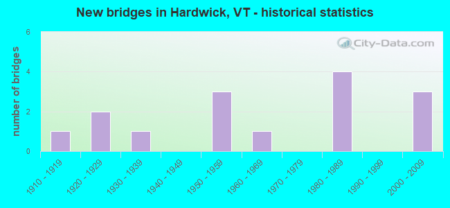
- New bridges - historical statistics
- 11910-1919
- 21920-1929
- 11930-1939
- 31950-1959
- 11960-1969
- 41980-1989
- 32000-2009

- Reconstructed bridges - Historical Statistics
- 11970-1979
- 11980-1989
- 01990-1999
- 12000-2009


- Bridge Condition - Deck
- 53.3%Very good
- 13.3%Good
- 26.7%Satisfactory
- 6.7%Fair

- Bridge Condition - Superstructure
- 53.3%Very good
- 20.0%Good
- 20.0%Satisfactory
- 6.7%Fair

- Bridge Condition - Substructure
- 26.7%Very good
- 33.3%Good
- 33.3%Satisfactory
- 6.7%Fair

- Bridge Condition - Channel
- 53.3%Very good
- 13.3%Good
- 33.3%Satisfactory
Find on map >> Show street view
Structure Number: 100305000403051, Location: 0.1 MI JCT TH 2 + TH 6 (Lat: 44.521139, Lng: -72.307956), Route carried "on" structure: Other road C2002, Year Built: 1925, Status: Open, Structure Length: 1.40m (4.59ft), Average Daily Traffic: 410 (year 2019), Truck Traffic: 2%, Average Future Daily Traffic: 431 (year 2029), Features Intersected: LAMOILLE RIVER
Minimum Vertical Clearance: 30+ m (98+ ft), Kilometerpoint: 0.000, Lanes on structure: 2, Owner: Town or Township Highway Agency, Approaching Roadway Width: 7.3m (24.0ft), Material/Design: Concrete, Design/Construction: Tee Beam, Number Of Spans In Main Unit: 1, Length of Maximum Span: 13.1m (43.0ft), Curb or Sidewalk Widths: Left: 1.6m (5.2ft), Right: 0.0m, Curb-To-Curb Width: 8.2m (26.9ft), Out-to-Out Width: 9.0m (29.5ft)
Condition: Deck: Fair, Superstructure: Fair, Substructure: Fair, Channel: Very good, Operating Rating: 28.1 metric tons, Method Used To Determine Operating Rating: Field evaluation and documented engineering judgment, Inventory Rating: 16.3 metric tons, Method Used To Determine Inventory Rating: Field evaluation and documented engineering judgment, Structural Evaluation: Somewhat better than minimum adequacy, Deck Geometry: Somewhat better than minimum adequacy, Waterway Adequacy: Equal to present desirable criteria, Approach Roadway Alignment: Equal to present minimum criteria, Length Of Structure Improvement: 1.40m (4.59ft), Designated Inspection Frequency: Every 24 months, Inspection Date: September 2021, Bridge Improvement Cost: $473,000, Roadway Improvement Cost: $50,000, Total Project Cost: $523,000 ( Estimate for 2020), Deck Structure Type: Concrete Cast-file-Place, Wearing Surface/Protective System: Wearing Surface: Bituminous
Find on map >> Show street view
Structure Number: 100305002303051, Location: AT JCT TH 53 + VT 15 (Lat: 44.495308, Lng: -72.318136), Route carried "on" structure: Other road C3053, Year Built: 1954, Year Reconstructed: 1993, Status: Posted for load, Structure Length: 1.04m (3.41ft), Average Daily Traffic: 10 (year 2019), Truck Traffic: 2%, Average Future Daily Traffic: 11 (year 2029), Features Intersected: HAYNESVILLE BROOK
Minimum Vertical Clearance: 30+ m (98+ ft), Kilometerpoint: 0.000, Lanes on structure: 1, Owner: Town or Township Highway Agency, Approaching Roadway Width: 5.5m (18.0ft), Material/Design: Steel, Design/Construction: Stringer/Multi-beam, Number Of Spans In Main Unit: 1, Length of Maximum Span: 7.9m (25.9ft), Curb-To-Curb Width: 4.6m (15.1ft), Out-to-Out Width: 4.9m (16.1ft)
Condition: Deck: Good, Superstructure: Satisfactory, Substructure: Satisfactory, Channel: Satisfactory, Operating Rating: 11.8 metric tons, Method Used To Determine Operating Rating: Allowable Stress (AS), Inventory Rating: 8.2 metric tons, Method Used To Determine Inventory Rating: Allowable Stress (AS), Structural Evaluation: High priority of replacement, Deck Geometry: Better than present minimum criteria, Waterway Adequacy: Somewhat better than minimum adequacy, Approach Roadway Alignment: Equal to present desirable criteria, Bridge Posting: Required (Relationship of Operating Rating to Maximum Legal Load: 0.1 - 9.9% below), Length Of Structure Improvement: 1.65m (5.41ft), Designated Inspection Frequency: Every 24 months, Inspection Date: September 2021, Bridge Improvement Cost: $295,000, Roadway Improvement Cost: $150,000, Total Project Cost: $445,000 ( Estimate for 2020), Deck Structure Type: Wood or Timber, Wearing Surface/Protective System: Wearing Surface: Wood or Timber
Find on map >> Show street view
Structure Number: 100305002403051, Location: AT JCT TH 49 + TH 46 (Lat: 44.490111, Lng: -72.366969), Route carried "on" structure: Other road C3049, Year Built: 2001, Status: Open, Structure Length: 1.40m (4.59ft), Average Daily Traffic: 100 (year 2019), Truck Traffic: 2%, Average Future Daily Traffic: 105 (year 2029), Design Load: HS 25 or greater, Features Intersected: NICHOLS BROOK
Minimum Vertical Clearance: 30+ m (98+ ft), Kilometerpoint: 0.000, Lanes on structure: 2, Owner: Town or Township Highway Agency, Approaching Roadway Width: 6.1m (20.0ft), Material/Design: Prestressed concrete, Design/Construction: Slab, Number Of Spans In Main Unit: 1, Length of Maximum Span: 13.4m (44.0ft), Curb or Sidewalk Widths: Left: 0.2m (0.7ft), Right: 0.2m (0.7ft), Curb-To-Curb Width: 5.3m (17.4ft), Out-to-Out Width: 6.0m (19.7ft)
Condition: Deck: Very good, Superstructure: Very good, Substructure: Good, Channel: Very good, Operating Rating: 68.0 metric tons, Method Used To Determine Operating Rating: Field evaluation and documented engineering judgment, Inventory Rating: 40.8 metric tons, Method Used To Determine Inventory Rating: Field evaluation and documented engineering judgment, Structural Evaluation: Better than present minimum criteria, Deck Geometry: High priority of corrective action, Waterway Adequacy: Equal to present desirable criteria, Approach Roadway Alignment: Equal to present desirable criteria, Length Of Structure Improvement: 1.40m (4.59ft), Designated Inspection Frequency: Every 24 months, Inspection Date: September 2021, Bridge Improvement Cost: $319,000, Roadway Improvement Cost: $50,000, Total Project Cost: $369,000 ( Estimate for 2020), Deck Structure Type: Concrete Precast Panels, Wearing Surface/Protective System: Wearing Surface: Integral Concrete
Find on map >> Show street view
Structure Number: 100305002503051, Location: 0.01 MI TO JCT W VT15 (Lat: 44.515225, Lng: -72.394672), Route carried "on" structure: Other road C3042, Year Built: 1989, Status: Open, Structure Length: 1.89m (6.20ft), Average Daily Traffic: 25 (year 2019), Truck Traffic: 20%, Average Future Daily Traffic: 27 (year 2029), Design Load: HS 20, Features Intersected: LAMOILLE RIVER
Minimum Vertical Clearance: 30+ m (98+ ft), Kilometerpoint: 0.000, Lanes on structure: 2, Owner: Town or Township Highway Agency, Approaching Roadway Width: 7.6m (24.9ft), Material/Design: Steel, Design/Construction: Stringer/Multi-beam, Number Of Spans In Main Unit: 1, Length of Maximum Span: 18.3m (60.0ft), Curb or Sidewalk Widths: Left: 0.2m (0.7ft), Right: 0.2m (0.7ft), Curb-To-Curb Width: 7.0m (23.0ft), Out-to-Out Width: 7.7m (25.3ft)
Condition: Deck: Very good, Superstructure: Very good, Substructure: Good, Channel: Good, Operating Rating: 89.8 metric tons, Method Used To Determine Operating Rating: Load Factor (LF), Inventory Rating: 62.6 metric tons, Method Used To Determine Inventory Rating: Load Factor (LF), Structural Evaluation: Better than present minimum criteria, Deck Geometry: Somewhat better than minimum adequacy, Waterway Adequacy: Equal to present desirable criteria, Approach Roadway Alignment: Equal to present desirable criteria, Designated Inspection Frequency: Every 24 months, Inspection Date: September 2021, Deck Structure Type: Concrete Cast-file-Place, Wearing Surface/Protective System: Wearing Surface: Bituminous, Membrane: Preformed Fabric, Deck Protection: Epoxy Coated Reinforcing
Find on map >> Show street view
Structure Number: 100305002803051, Location: 0.05 MI JCT TH 30 + VT16 (Lat: 44.509533, Lng: -72.317536), Route carried "on" structure: Other road C3030, Year Built: 1950, Status: Open, Structure Length: 1.65m (5.41ft), Average Daily Traffic: 10 (year 2019), Truck Traffic: 2%, Average Future Daily Traffic: 11 (year 2029), Features Intersected: LAMOILLE RIVER
Minimum Vertical Clearance: 30+ m (98+ ft), Kilometerpoint: 0.000, Lanes on structure: 1, Owner: Town or Township Highway Agency, Approaching Roadway Width: 4.9m (16.1ft), Material/Design: Steel, Design/Construction: Stringer/Multi-beam, Number Of Spans In Main Unit: 1, Length of Maximum Span: 15.8m (51.8ft), Curb-To-Curb Width: 4.0m (13.1ft), Out-to-Out Width: 4.9m (16.1ft)
Condition: Deck: Satisfactory, Superstructure: Satisfactory, Substructure: Satisfactory, Channel: Satisfactory, Operating Rating: 13.6 metric tons, Method Used To Determine Operating Rating: Allowable Stress (AS), Inventory Rating: 10.0 metric tons, Method Used To Determine Inventory Rating: Allowable Stress (AS), Structural Evaluation: High priority of replacement, Deck Geometry: Somewhat better than minimum adequacy, Waterway Adequacy: Equal to present minimum criteria, Approach Roadway Alignment: Meets minimum limits, Length Of Structure Improvement: 2.32m (7.61ft), Designated Inspection Frequency: Every 24 months, Inspection Date: September 2021, Bridge Improvement Cost: $405,000, Roadway Improvement Cost: $150,000, Total Project Cost: $555,000 ( Estimate for 2020), Deck Structure Type: Wood or Timber, Wearing Surface/Protective System: Wearing Surface: Wood or Timber
Find on map >> Show street view
Structure Number: 100305002903051, Location: 0.05 MI JCT TH 31 + VT16 (Lat: 44.505469, Lng: -72.318500), Route carried "on" structure: Other road C3031, Year Built: 2002, Status: Open, Structure Length: 2.47m (8.10ft), Average Daily Traffic: 90 (year 2019), Truck Traffic: 2%, Average Future Daily Traffic: 95 (year 2029), Design Load: HS 25 or greater, Features Intersected: LAMOILLE RIVER
Minimum Vertical Clearance: 30+ m (98+ ft), Kilometerpoint: 0.000, Lanes on structure: 1, Owner: Town or Township Highway Agency, Approaching Roadway Width: 6.1m (20.0ft), Skew: 1 degrees, Material/Design: Prestressed concrete, Design/Construction: Box Beam or Girders - Multiple, Number Of Spans In Main Unit: 1, Length of Maximum Span: 24.1m (79.1ft), Curb or Sidewalk Widths: Left: 0.2m (0.7ft), Right: 0.2m (0.7ft), Curb-To-Curb Width: 4.7m (15.4ft), Out-to-Out Width: 5.5m (18.0ft)
Condition: Deck: Very good, Superstructure: Very good, Substructure: Very good, Channel: Very good, Operating Rating: 89.8 metric tons, Method Used To Determine Operating Rating: Allowable Stress (AS), Inventory Rating: 44.5 metric tons, Method Used To Determine Inventory Rating: Allowable Stress (AS), Structural Evaluation: Equal to present desirable criteria, Deck Geometry: Better than present minimum criteria, Waterway Adequacy: Equal to present desirable criteria, Approach Roadway Alignment: Equal to present desirable criteria, Designated Inspection Frequency: Every 24 months, Inspection Date: September 2021, Deck Structure Type: Concrete Cast-file-Place, Wearing Surface/Protective System: Wearing Surface: Monolithic Concrete, Deck Protection: Epoxy Coated Reinforcing
Find on map >> Show street view
Structure Number: 100305003003051, Location: 0.01 MI S JCT VT 15 (Lat: 44.522283, Lng: -72.415669), Route carried "on" structure: Other road C3039, Year Built: 1981, Status: Open, Structure Length: 3.05m (10.01ft), Average Daily Traffic: 100 (year 2019), Truck Traffic: 2%, Average Future Daily Traffic: 105 (year 2029), Design Load: HS 20, Features Intersected: LAMOILLE RIVER
Minimum Vertical Clearance: 30+ m (98+ ft), Kilometerpoint: 0.000, Lanes on structure: 2, Owner: Town or Township Highway Agency, Approaching Roadway Width: 7.0m (23.0ft), Skew: 2 degrees, Material/Design: Steel continuous, Design/Construction: Stringer/Multi-beam, Number Of Spans In Main Unit: 3, Length of Maximum Span: 21.3m (69.9ft), Curb or Sidewalk Widths: Left: 0.2m (0.7ft), Right: 0.2m (0.7ft), Curb-To-Curb Width: 6.9m (22.6ft), Out-to-Out Width: 7.8m (25.6ft)
Condition: Deck: Very good, Superstructure: Very good, Substructure: Very good, Channel: Very good, Operating Rating: 52.6 metric tons, Method Used To Determine Operating Rating: Allowable Stress (AS), Inventory Rating: 33.6 metric tons, Method Used To Determine Inventory Rating: Allowable Stress (AS), Structural Evaluation: Equal to present desirable criteria, Deck Geometry: Somewhat better than minimum adequacy, Waterway Adequacy: Equal to present desirable criteria, Approach Roadway Alignment: Equal to present desirable criteria, Designated Inspection Frequency: Every 24 months, Inspection Date: September 2021, Deck Structure Type: Concrete Cast-file-Place, Wearing Surface/Protective System: Deck Protection: Epoxy Coated Reinforcing
Find on map >> Show street view
Structure Number: 100305003103051, Location: 0.1 MI JCT TH 5 + VT 16 (Lat: 44.541814, Lng: -72.267564), Route carried "on" structure: Other road C2005, Year Built: 1924, Status: Open, Structure Length: 1.31m (4.30ft), Average Daily Traffic: 750 (year 2019), Truck Traffic: 3%, Average Future Daily Traffic: 788 (year 2029), Features Intersected: LAMOILLE RIVER
Minimum Vertical Clearance: 30+ m (98+ ft), Kilometerpoint: 0.000, Lanes on structure: 2, Owner: Town or Township Highway Agency, Approaching Roadway Width: 6.7m (22.0ft), Skew: 3 degrees, Material/Design: Concrete, Design/Construction: Tee Beam, Number Of Spans In Main Unit: 1, Length of Maximum Span: 12.2m (40.0ft), Curb or Sidewalk Widths: Left: 0.1m (0.3ft), Right: 0.1m (0.3ft), Curb-To-Curb Width: 6.4m (21.0ft), Out-to-Out Width: 7.1m (23.3ft)
Condition: Deck: Satisfactory, Superstructure: Satisfactory, Substructure: Satisfactory, Channel: Satisfactory, Operating Rating: 28.1 metric tons, Method Used To Determine Operating Rating: Field evaluation and documented engineering judgment, Inventory Rating: 16.3 metric tons, Method Used To Determine Inventory Rating: Field evaluation and documented engineering judgment, Structural Evaluation: Meets minimum limits, Deck Geometry: High priority of corrective action, Waterway Adequacy: Better than present minimum criteria, Approach Roadway Alignment: Equal to present desirable criteria, Length Of Structure Improvement: 1.31m (4.30ft), Designated Inspection Frequency: Every 24 months, Inspection Date: September 2021, Bridge Improvement Cost: $351,000, Roadway Improvement Cost: $50,000, Total Project Cost: $401,000 ( Estimate for 2020), Deck Structure Type: Concrete Cast-file-Place, Wearing Surface/Protective System: Wearing Surface: Bituminous
Find on map >> Show street view
Structure Number: 100305004203051, Location: ON ELM ST 0.2 MI W VT 15 (Lat: 44.502825, Lng: -72.373853), Route carried "on" structure: Other road C3ELM, Year Built: 1985, Status: Open, Structure Length: 1.19m (3.90ft), Average Daily Traffic: 75 (year 2019), Truck Traffic: 6%, Average Future Daily Traffic: 79 (year 2029), Design Load: HS 20, Features Intersected: COOPER BROOK
Minimum Vertical Clearance: 30+ m (98+ ft), Kilometerpoint: 0.000, Lanes on structure: 2, Owner: Town or Township Highway Agency, Approaching Roadway Width: 6.7m (22.0ft), Skew: 4 degrees, Material/Design: Concrete, Design/Construction: Slab, Number Of Spans In Main Unit: 1, Length of Maximum Span: 11.3m (37.1ft), Curb-To-Curb Width: 7.3m (24.0ft), Out-to-Out Width: 7.7m (25.3ft)
Condition: Deck: Very good, Superstructure: Very good, Substructure: Very good, Channel: Satisfactory, Operating Rating: 89.8 metric tons, Method Used To Determine Operating Rating: Load Factor (LF), Inventory Rating: 62.6 metric tons, Method Used To Determine Inventory Rating: Load Factor (LF), Structural Evaluation: Equal to present desirable criteria, Deck Geometry: Equal to present minimum criteria, Waterway Adequacy: Better than present minimum criteria, Approach Roadway Alignment: Equal to present desirable criteria, Designated Inspection Frequency: Every 24 months, Inspection Date: September 2021, Deck Structure Type: Concrete Cast-file-Place
Find on map >> Show street view
Structure Number: 100305004303051, Location: @ JCT W CL1 TH1 (Lat: 44.506564, Lng: -72.369919), Route carried "on" structure: Other road C3WCS, Year Built: 1965, Status: Open, Structure Length: 3.02m (9.91ft), Average Daily Traffic: 750 (year 2019), Truck Traffic: 2%, Average Future Daily Traffic: 788 (year 2029), Design Load: H 20, Features Intersected: LAMOILLE RIVER, Facility Carried by Structure: C30WC
Minimum Vertical Clearance: 30+ m (98+ ft), Kilometerpoint: 0.000, Lanes on structure: 2, Owner: Town or Township Highway Agency, Approaching Roadway Width: 7.3m (24.0ft), Material/Design: Steel, Design/Construction: Stringer/Multi-beam, Number Of Spans In Main Unit: 1, Length of Maximum Span: 29.6m (97.1ft), Curb or Sidewalk Widths: Left: 0.5m (1.6ft), Right: 0.5m (1.6ft), Curb-To-Curb Width: 7.3m (24.0ft), Out-to-Out Width: 8.8m (28.9ft)
Condition: Deck: Satisfactory, Superstructure: Good, Substructure: Satisfactory, Channel: Good, Operating Rating: 71.7 metric tons, Method Used To Determine Operating Rating: Allowable Stress (AS), Inventory Rating: 39.9 metric tons, Method Used To Determine Inventory Rating: Allowable Stress (AS), Structural Evaluation: Equal to present minimum criteria, Deck Geometry: Meets minimum limits, Waterway Adequacy: Better than present minimum criteria, Approach Roadway Alignment: Equal to present desirable criteria, Designated Inspection Frequency: Every 24 months, Inspection Date: September 2021, Deck Structure Type: Concrete Cast-file-Place, Wearing Surface/Protective System: Wearing Surface: Bituminous
Find on map >> Show street view
Structure Number: 200030006603052, Location: 0.1 MI E JCT. VT.14 N (Lat: 44.516869, Lng: -72.378564), Route carried "on" structure: State highway 15, Year Built: 1984, Status: Open, Structure Length: 2.80m (9.19ft), Average Daily Traffic: 6,300 (year 2018), Truck Traffic: 9%, Average Future Daily Traffic: 6,615 (year 2028), Design Load: HS 25 or greater, Features Intersected: LAMOILLE RIVER
Minimum Vertical Clearance: 30+ m (98+ ft), Kilometerpoint: 88.559, Lanes on structure: 2, Base Highway Network: Yes, Owner: State Highway Agency, Approaching Roadway Width: 12.2m (40.0ft), Material/Design: Steel, Design/Construction: Stringer/Multi-beam, Number Of Spans In Main Unit: 1, Length of Maximum Span: 27.4m (89.9ft), Curb or Sidewalk Widths: Left: 0.2m (0.7ft), Right: 0.2m (0.7ft), Curb-To-Curb Width: 12.0m (39.4ft), Out-to-Out Width: 13.0m (42.7ft)
Condition: Deck: Good, Superstructure: Very good, Substructure: Good, Channel: Very good, Operating Rating: 89.8 metric tons, Method Used To Determine Operating Rating: Allowable Stress (AS), Inventory Rating: 49.9 metric tons, Method Used To Determine Inventory Rating: Allowable Stress (AS), Structural Evaluation: Better than present minimum criteria, Deck Geometry: Somewhat better than minimum adequacy, Waterway Adequacy: Equal to present desirable criteria, Approach Roadway Alignment: Equal to present desirable criteria, Designated Inspection Frequency: Every 24 months, Inspection Date: July 2021, Deck Structure Type: Concrete Cast-file-Place, Wearing Surface/Protective System: Wearing Surface: Bituminous, Membrane: Preformed Fabric
Find on map >> Show street view
Structure Number: 200030006703052, Location: 0.4 MI W JCT. VT.14 S (Lat: 44.508450, Lng: -72.371714), Route carried "on" structure: State highway 15, Year Built: 1935, Year Reconstructed: 2009, Status: Open, Structure Length: 1.95m (6.40ft), Average Daily Traffic: 9,000 (year 2018), Truck Traffic: 7%, Average Future Daily Traffic: 9,450 (year 2028), Design Load: HS 25 or greater, Features Intersected: COOPER BROOK
Minimum Vertical Clearance: 30+ m (98+ ft), Kilometerpoint: 89.766, Lanes on structure: 2, Base Highway Network: Yes, Owner: Town or Township Highway Agency, Approaching Roadway Width: 9.1m (29.9ft), Material/Design: Steel, Design/Construction: Stringer/Multi-beam, Number Of Spans In Main Unit: 1, Length of Maximum Span: 18.9m (62.0ft), Curb or Sidewalk Widths: Left: 0.1m (0.3ft), Right: 1.6m (5.2ft), Curb-To-Curb Width: 9.0m (29.5ft), Out-to-Out Width: 11.6m (38.1ft)
Condition: Deck: Very good, Superstructure: Very good, Substructure: Very good, Channel: Very good, Operating Rating: 88.9 metric tons, Method Used To Determine Operating Rating: Load Factor (LF), Inventory Rating: 52.6 metric tons, Method Used To Determine Inventory Rating: Load Factor (LF), Structural Evaluation: Equal to present desirable criteria, Deck Geometry: High priority of replacement, Waterway Adequacy: Equal to present minimum criteria, Approach Roadway Alignment: Equal to present desirable criteria, Length Of Structure Improvement: 1.95m (6.40ft), Designated Inspection Frequency: Every 24 months, Inspection Date: July 2021, Bridge Improvement Cost: $853,000, Roadway Improvement Cost: $50,000, Total Project Cost: $903,000 ( Estimate for 2020), Deck Structure Type: Concrete Cast-file-Place, Wearing Surface/Protective System: Wearing Surface: Bituminous, Membrane: Preformed Fabric, Deck Protection: Epoxy Coated Reinforcing
Find on map >> Show street view
Structure Number: 200037000203052, Location: 2.3 MI N JCT. VT.15 (Lat: 44.524150, Lng: -72.295917), Route carried "on" structure: State highway 16, Year Built: 1919, Year Reconstructed: 1979, Status: Open, Structure Length: 3.29m (10.79ft), Average Daily Traffic: 2,500 (year 2018), Truck Traffic: 9%, Average Future Daily Traffic: 2,625 (year 2028), Design Load: H 15, Features Intersected: LAMOILLE RIVER
Minimum Vertical Clearance: 30+ m (98+ ft), Kilometerpoint: 3.765, Lanes on structure: 2, Base Highway Network: Yes (Inventory Route: 500000, Subroute: 1), Owner: State Highway Agency, Approaching Roadway Width: 10.1m (33.1ft), Skew: 1 degrees, Material/Design: Steel, Design/Construction: Stringer/Multi-beam, Number Of Spans In Main Unit: 2, Length of Maximum Span: 15.8m (51.8ft), Curb or Sidewalk Widths: Left: 0.1m (0.3ft), Right: 0.1m (0.3ft), Curb-To-Curb Width: 10.2m (33.5ft), Out-to-Out Width: 10.9m (35.8ft)
Condition: Deck: Very good, Superstructure: Good, Substructure: Good, Channel: Satisfactory, Operating Rating: 66.2 metric tons, Method Used To Determine Operating Rating: Allowable Stress (AS), Inventory Rating: 39.0 metric tons, Method Used To Determine Inventory Rating: Allowable Stress (AS), Structural Evaluation: Better than present minimum criteria, Deck Geometry: Meets minimum limits, Waterway Adequacy: Better than present minimum criteria, Approach Roadway Alignment: Equal to present desirable criteria, Designated Inspection Frequency: Every 24 months, Inspection Date: July 2021, Deck Structure Type: Concrete Cast-file-Place, Wearing Surface/Protective System: Wearing Surface: Bituminous, Membrane: Preformed Fabric
Find on map >> Show street view
Structure Number: 200037000303052, Location: 3.3 MI N JCT. VT.15 (Lat: 44.532769, Lng: -72.281597), Route carried "on" structure: State highway 16, Year Built: 1952, Status: Open, Structure Length: 1.04m (3.41ft), Average Daily Traffic: 2,500 (year 2018), Truck Traffic: 9%, Average Future Daily Traffic: 2,625 (year 2028), Design Load: H 15, Features Intersected: GREENSBORO BROOK
Minimum Vertical Clearance: 30+ m (98+ ft), Kilometerpoint: 5.326, Lanes on structure: 2, Base Highway Network: Yes (Inventory Route: 500000, Subroute: 1), Owner: State Highway Agency, Approaching Roadway Width: 9.4m (30.8ft), Skew: 2 degrees, Material/Design: Steel, Design/Construction: Stringer/Multi-beam, Number Of Spans In Main Unit: 1, Length of Maximum Span: 9.4m (30.8ft), Curb or Sidewalk Widths: Left: 0.2m (0.7ft), Right: 0.2m (0.7ft), Curb-To-Curb Width: 9.0m (29.5ft), Out-to-Out Width: 10.3m (33.8ft)
Condition: Deck: Satisfactory, Superstructure: Good, Substructure: Satisfactory, Channel: Very good, Operating Rating: 46.3 metric tons, Method Used To Determine Operating Rating: Load Factor (LF), Inventory Rating: 27.2 metric tons, Method Used To Determine Inventory Rating: Load Factor (LF), Structural Evaluation: Equal to present minimum criteria, Deck Geometry: Meets minimum limits, Waterway Adequacy: Equal to present desirable criteria, Approach Roadway Alignment: Equal to present desirable criteria, Length Of Structure Improvement: 1.04m (3.41ft), Designated Inspection Frequency: Every 25 months, Inspection Date: July 2021, Bridge Improvement Cost: $401,000, Roadway Improvement Cost: $50,000, Total Project Cost: $451,000 ( Estimate for 2020), Deck Structure Type: Concrete Cast-file-Place, Wearing Surface/Protective System: Wearing Surface: Bituminous, Membrane: Preformed Fabric
Find on map >> Show street view
Structure Number: 200257004103052, Location: 0.1 MI N JCT. VT.15 (Lat: 44.504900, Lng: -72.365881), Route carried "on" structure: County highway 3, Year Built: 2000, Status: Open, Structure Length: 2.29m (7.51ft), Average Daily Traffic: 6,250 (year 2017), Truck Traffic: 6%, Average Future Daily Traffic: 6,563 (year 2027), Design Load: HS 25 or greater, Features Intersected: LAMOILLE RIVER
Minimum Vertical Clearance: 30+ m (98+ ft), Kilometerpoint: 0.000, Lanes on structure: 2, Owner: Town or Township Highway Agency, Approaching Roadway Width: 10.1m (33.1ft), Skew: 1 degrees, Material/Design: Prestressed concrete, Design/Construction: Box Beam or Girders - Multiple, Number Of Spans In Main Unit: 1, Length of Maximum Span: 22.3m (73.2ft), Curb or Sidewalk Widths: Left: 1.7m (5.6ft), Right: 1.7m (5.6ft), Curb-To-Curb Width: 9.7m (31.8ft), Out-to-Out Width: 13.9m (45.6ft)
Condition: Deck: Very good, Superstructure: Very good, Substructure: Good, Channel: Very good, Operating Rating: 60.8 metric tons, Method Used To Determine Operating Rating: Load Factor (LF), Inventory Rating: 43.5 metric tons, Method Used To Determine Inventory Rating: Load Factor (LF), Structural Evaluation: Better than present minimum criteria, Deck Geometry: High priority of corrective action, Waterway Adequacy: Equal to present desirable criteria, Approach Roadway Alignment: Equal to present desirable criteria, Designated Inspection Frequency: Every 24 months, Inspection Date: July 2020, Deck Structure Type: Concrete Precast Panels, Wearing Surface/Protective System: Wearing Surface: Bituminous, Membrane: Preformed Fabric, Deck Protection: Epoxy Coated Reinforcing