Bridge Statistics for Haring, Michigan (MI)
Condition, Traffic, Stress, Structural Evaluation, Project Costs
- National Bridge Inventory (NBI) Statistics
- 15Number of bridges
- 167ft / 51.1mTotal length
- 137,371Total average daily traffic
- 7,280Total average daily truck traffic
- National Bridge Inventory (NBI) Registered Bridges for Haring
- No street view available for this location
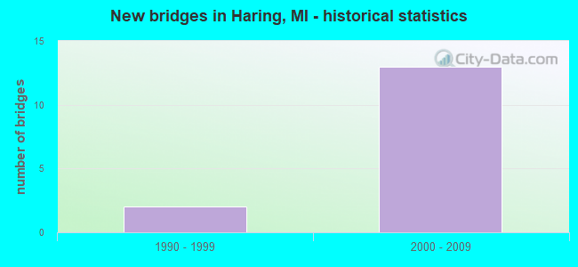
- New bridges - historical statistics
- 21990-1999
- 132000-2009


- Bridge Condition - Deck
- 44.4%Very good
- 33.3%Good
- 22.2%Satisfactory

- Bridge Condition - Superstructure
- 33.3%Very good
- 33.3%Good
- 33.3%Satisfactory

- Bridge Condition - Substructure
- 77.8%Good
- 22.2%Satisfactory

- Bridge Condition - Channel
- 66.7%Very good
- 33.3%Good
Find on map >> Show street view
Structure Number: 1274, Location: HARING TWP SEC 27 & 34 (Lat: 44.267044, Lng: -85.387742), Route carried "on" structure: County highway 36, Year Built: 1997, Status: Open, Structure Length: 4.45m (14.60ft), Average Daily Traffic: 77,777 (year 1995), Average Future Daily Traffic: 77,777 (year 2015), Design Load: HS 25 or greater, Features Intersected: US-131, Facility Carried by Structure: E 13TH ST
Minimum Vertical Clearance: 30.48m (100.00ft), Kilometerpoint: 7.141, Lanes on structure: 2, Lanes under structure: 4, Base Highway Network: Yes (Inventory Route: 112, Subroute: 1), Owner: State Highway Agency, Approaching Roadway Width: 12.2m (40.0ft), Skew: 1 degrees, Material/Design: Prestressed concrete, Design/Construction: Stringer/Multi-beam, Number Of Spans In Main Unit: 1, Length of Maximum Span: 43.1m (141.4ft), Curb-To-Curb Width: 13.4m (44.0ft), Out-to-Out Width: 14.4m (47.2ft)
Condition: Deck: Good, Superstructure: Very good, Substructure: Satisfactory, Operating Rating: 75.5 metric tons, Method Used To Determine Operating Rating: Load Factor (LF) rating reported by rating factor (RF) method using MS18 loading, Inventory Rating: 35.0 metric tons, Method Used To Determine Inventory Rating: Load Factor (LF) rating reported by rating factor (RF) method using MS18 loading, Structural Evaluation: Equal to present minimum criteria, Deck Geometry: Equal to present minimum criteria, Underclear: Equal to present minimum criteria, Approach Roadway Alignment: Equal to present desirable criteria, Designated Inspection Frequency: Every 24 months, Inspection Date: August 2020, Deck Structure Type: Concrete Cast-file-Place, Wearing Surface/Protective System: Wearing Surface: Epoxy Overlay, Deck Protection: Epoxy Coated Reinforcing
Find on map >> Show street view
Structure Number: 12871, Location: HARING TWP SEC 22 (Lat: 44.281497, Lng: -85.388486), Route carried "on" structure: County highway 34, Year Built: 2000, Status: Open, Structure Length: 8.12m (26.64ft), Average Daily Traffic: 1,740 (year 2000), Truck Traffic: 10%, Average Future Daily Traffic: 1,740 (year 2010), Design Load: HS 25 or greater, Features Intersected: US-131, Facility Carried by Structure: BOON RD
Minimum Vertical Clearance: 30.48m (100.00ft), Kilometerpoint: 20.187, Lanes on structure: 4, Lanes under structure: 6, Owner: State Highway Agency, Approaching Roadway Width: 26.2m (86.0ft), Material/Design: Prestressed concrete, Design/Construction: Stringer/Multi-beam, Number Of Spans In Main Unit: 2, Length of Maximum Span: 40.8m (133.9ft), Curb-To-Curb Width: 25.6m (84.0ft), Out-to-Out Width: 26.6m (87.3ft)
Condition: Deck: Good, Superstructure: Satisfactory, Substructure: Good, Operating Rating: 77.1 metric tons, Method Used To Determine Operating Rating: Load Factor (LF) rating reported by rating factor (RF) method using MS18 loading, Inventory Rating: 41.1 metric tons, Method Used To Determine Inventory Rating: Load Factor (LF) rating reported by rating factor (RF) method using MS18 loading, Structural Evaluation: Equal to present minimum criteria, Deck Geometry: Superior to present desirable criteria, Underclear: Superior to present desirable criteria, Approach Roadway Alignment: Equal to present desirable criteria, Designated Inspection Frequency: Every 24 months, Inspection Date: July 2021, Deck Structure Type: Concrete Cast-file-Place, Wearing Surface/Protective System: Wearing Surface: Epoxy Overlay, Deck Protection: Epoxy Coated Reinforcing
Find on map >> Show street view
Structure Number: 12953, Location: 0.1 MI S OF BOON ROAD (Lat: 44.280072, Lng: -85.388492), Route carried "on" structure: US 131, Year Built: 2000, Status: Open, Structure Length: 2.01m (6.59ft), Average Daily Traffic: 4,255 (year 2007), Truck Traffic: 11%, Average Future Daily Traffic: 3,375 (year 2018), Design Load: HS 25 or greater, Features Intersected: CLAM RIVER
Minimum Vertical Clearance: 30.48m (100.00ft), Kilometerpoint: 15.487, Lanes on structure: 3, Base Highway Network: Yes (Inventory Route: 383, Subroute: 27), Owner: State Highway Agency, Approaching Roadway Width: 17.1m (56.1ft), Skew: 2 degrees, Material/Design: Prestressed concrete, Design/Construction: Stringer/Multi-beam, Number Of Spans In Main Unit: 1, Length of Maximum Span: 20.1m (65.9ft), Curb-To-Curb Width: 17.1m (56.1ft), Out-to-Out Width: 18.0m (59.1ft)
Condition: Deck: Very good, Superstructure: Very good, Substructure: Good, Channel: Good, Operating Rating: 64.8 metric tons, Method Used To Determine Operating Rating: Load Factor (LF) rating reported by rating factor (RF) method using MS18 loading, Inventory Rating: 33.4 metric tons, Method Used To Determine Inventory Rating: Load Factor (LF) rating reported by rating factor (RF) method using MS18 loading, Structural Evaluation: Better than present minimum criteria, Deck Geometry: Superior to present desirable criteria, Waterway Adequacy: Superior to present desirable criteria, Approach Roadway Alignment: Equal to present desirable criteria, Designated Inspection Frequency: Every 24 months, Inspection Date: July 2021, Deck Structure Type: Concrete Cast-file-Place, Wearing Surface/Protective System: Wearing Surface: Epoxy Overlay, Deck Protection: Epoxy Coated Reinforcing
Find on map >> Show street view
Structure Number: 12954, Location: 0.1 MI S OF BOON ROAD (Lat: 44.279994, Lng: -85.388811), Route carried "on" structure: US 131, Year Built: 2000, Status: Open, Structure Length: 2.01m (6.59ft), Average Daily Traffic: 4,255 (year 2007), Truck Traffic: 11%, Average Future Daily Traffic: 3,375 (year 2018), Design Load: HS 25 or greater, Features Intersected: CLAM RIVER
Minimum Vertical Clearance: 30.48m (100.00ft), Kilometerpoint: 15.505, Lanes on structure: 3, Base Highway Network: Yes (Inventory Route: 383, Subroute: 28), Owner: State Highway Agency, Approaching Roadway Width: 17.1m (56.1ft), Skew: 2 degrees, Material/Design: Prestressed concrete, Design/Construction: Stringer/Multi-beam, Number Of Spans In Main Unit: 1, Length of Maximum Span: 20.1m (65.9ft), Curb-To-Curb Width: 17.1m (56.1ft), Out-to-Out Width: 18.0m (59.1ft)
Condition: Deck: Very good, Superstructure: Very good, Substructure: Good, Channel: Very good, Operating Rating: 64.8 metric tons, Method Used To Determine Operating Rating: Load Factor (LF) rating reported by rating factor (RF) method using MS18 loading, Inventory Rating: 33.4 metric tons, Method Used To Determine Inventory Rating: Load Factor (LF) rating reported by rating factor (RF) method using MS18 loading, Structural Evaluation: Better than present minimum criteria, Deck Geometry: Superior to present desirable criteria, Waterway Adequacy: Equal to present desirable criteria, Approach Roadway Alignment: Equal to present desirable criteria, Designated Inspection Frequency: Every 24 months, Inspection Date: July 2021, Deck Structure Type: Concrete Cast-file-Place, Wearing Surface/Protective System: Wearing Surface: Epoxy Overlay, Deck Protection: Epoxy Coated Reinforcing
Find on map >> Show street view
Structure Number: 12955, Location: 0.2 MI E OF US-131 (Lat: 44.281489, Lng: -85.384422), Route carried "on" structure: Business US 131, Year Built: 2000, Status: Open, Structure Length: 0.67m (2.20ft), Average Daily Traffic: 1,740 (year 2000), Truck Traffic: 6%, Average Future Daily Traffic: 9,430 (year 2015), Design Load: HS 20, Features Intersected: CLAM RIVER
Minimum Vertical Clearance: 30.48m (100.00ft), Kilometerpoint: 20.510, Lanes on structure: 4, Base Highway Network: Yes (Inventory Route: 113, Subroute: 7), Owner: State Highway Agency, Approaching Roadway Width: 23.8m (78.1ft), Skew: 1 degrees, Material/Design: Concrete, Design/Construction: Culvert, Number Of Spans In Main Unit: 1, Length of Maximum Span: 6.1m (20.0ft), Curb-To-Curb Width: 23.8m (78.1ft), Out-to-Out Width: 41.5m (136.2ft)
Condition: Channel: Very good, Culverts: Satisfactory, Operating Rating: 51.2 metric tons, Method Used To Determine Operating Rating: Load Factor (LF) rating reported by rating factor (RF) method using MS18 loading, Inventory Rating: 30.8 metric tons, Method Used To Determine Inventory Rating: Load Factor (LF) rating reported by rating factor (RF) method using MS18 loading, Structural Evaluation: Equal to present minimum criteria, Deck Geometry: Superior to present desirable criteria, Waterway Adequacy: Equal to present desirable criteria, Approach Roadway Alignment: Better than present minimum criteria, Designated Inspection Frequency: Every 24 months, Inspection Date: July 2021, Deck Structure Type: Concrete Cast-file-Place, Wearing Surface/Protective System: Wearing Surface: Bituminous
Find on map >> Show street view
Structure Number: 12956, Location: 2 MI N OF BOON ROAD (Lat: 44.310308, Lng: -85.392581), Route carried "on" structure: County highway 30, Year Built: 2000, Status: Open, Structure Length: 7.25m (23.79ft), Average Daily Traffic: 340 (year 2000), Truck Traffic: 10%, Average Future Daily Traffic: 340 (year 2010), Design Load: HS 25 or greater, Features Intersected: US-131
Minimum Vertical Clearance: 30.48m (100.00ft), Kilometerpoint: 4.646, Lanes on structure: 2, Lanes under structure: 4, Owner: State Highway Agency, Approaching Roadway Width: 13.1m (43.0ft), Skew: 1 degrees, Material/Design: Prestressed concrete, Design/Construction: Stringer/Multi-beam, Number Of Spans In Main Unit: 2, Length of Maximum Span: 37.8m (124.0ft), Curb-To-Curb Width: 13.4m (44.0ft), Out-to-Out Width: 14.4m (47.2ft)
Condition: Deck: Satisfactory, Superstructure: Satisfactory, Substructure: Good, Operating Rating: 84.2 metric tons, Method Used To Determine Operating Rating: Load Factor (LF) rating reported by rating factor (RF) method using MS18 loading, Inventory Rating: 24.0 metric tons, Method Used To Determine Inventory Rating: Load Factor (LF) rating reported by rating factor (RF) method using MS18 loading, Structural Evaluation: Equal to present minimum criteria, Deck Geometry: Superior to present desirable criteria, Underclear: Better than present minimum criteria, Approach Roadway Alignment: Equal to present desirable criteria, Designated Inspection Frequency: Every 24 months, Inspection Date: September 2020, Deck Structure Type: Concrete Cast-file-Place, Wearing Surface/Protective System: Wearing Surface: Epoxy Overlay, Deck Protection: Epoxy Coated Reinforcing
Find on map >> Show street view
Structure Number: 12998, Location: HARING TWP SEC 15 (Lat: 44.299733, Lng: -85.392164), Route carried "on" structure: US 131, Year Built: 2000, Status: Open, Structure Length: 7.46m (24.48ft), Average Daily Traffic: 3,575 (year 2007), Truck Traffic: 11%, Average Future Daily Traffic: 3,796 (year 2018), Design Load: HS 25 or greater, Features Intersected: BOG
Minimum Vertical Clearance: 30.48m (100.00ft), Kilometerpoint: 17.716, Lanes on structure: 2, Base Highway Network: Yes (Inventory Route: 383, Subroute: 27), Owner: State Highway Agency, Approaching Roadway Width: 13.4m (44.0ft), Material/Design: Prestressed concrete, Design/Construction: Stringer/Multi-beam, Number Of Spans In Main Unit: 3, Length of Maximum Span: 44.2m (145.0ft), Curb-To-Curb Width: 14.9m (48.9ft), Out-to-Out Width: 16.0m (52.5ft)
Condition: Deck: Satisfactory, Superstructure: Satisfactory, Substructure: Satisfactory, Operating Rating: 75.8 metric tons, Method Used To Determine Operating Rating: Load Factor (LF) rating reported by rating factor (RF) method using MS18 loading, Inventory Rating: 45.4 metric tons, Method Used To Determine Inventory Rating: Load Factor (LF) rating reported by rating factor (RF) method using MS18 loading, Structural Evaluation: Equal to present minimum criteria, Deck Geometry: Superior to present desirable criteria, Approach Roadway Alignment: Equal to present desirable criteria, Designated Inspection Frequency: Every 24 months, Inspection Date: June 2020, Deck Structure Type: Concrete Cast-file-Place, Wearing Surface/Protective System: Wearing Surface: Epoxy Overlay, Deck Protection: Epoxy Coated Reinforcing
Find on map >> Show street view
Structure Number: 12999, Location: HARING TWP SEC 15 (Lat: 44.299792, Lng: -85.391811), Route carried "on" structure: US 131, Year Built: 2000, Status: Open, Structure Length: 7.46m (24.48ft), Average Daily Traffic: 3,575 (year 2007), Truck Traffic: 11%, Average Future Daily Traffic: 3,796 (year 2018), Design Load: HS 25 or greater, Features Intersected: BOG
Minimum Vertical Clearance: 30.48m (100.00ft), Kilometerpoint: 17.736, Lanes on structure: 2, Base Highway Network: Yes (Inventory Route: 383, Subroute: 28), Owner: State Highway Agency, Approaching Roadway Width: 13.4m (44.0ft), Skew: 10 degrees, Material/Design: Prestressed concrete, Design/Construction: Stringer/Multi-beam, Number Of Spans In Main Unit: 3, Length of Maximum Span: 44.2m (145.0ft), Curb-To-Curb Width: 14.9m (48.9ft), Out-to-Out Width: 16.0m (52.5ft)
Condition: Deck: Good, Superstructure: Good, Substructure: Good, Operating Rating: 58.6 metric tons, Method Used To Determine Operating Rating: Load Factor (LF) rating reported by rating factor (RF) method using MS18 loading, Inventory Rating: 35.0 metric tons, Method Used To Determine Inventory Rating: Load Factor (LF) rating reported by rating factor (RF) method using MS18 loading, Structural Evaluation: Better than present minimum criteria, Deck Geometry: Superior to present desirable criteria, Approach Roadway Alignment: Equal to present desirable criteria, Designated Inspection Frequency: Every 24 months, Inspection Date: June 2020, Deck Structure Type: Concrete Cast-file-Place, Wearing Surface/Protective System: Wearing Surface: Epoxy Overlay, Deck Protection: Epoxy Coated Reinforcing
Find on map >> Show street view
Structure Number: 13, Location: 5.8 MI N OF M-55 (Lat: 44.327792, Lng: -85.403753), Route carried "on" structure: US 131, Year Built: 2000, Status: Open, Structure Length: 5.82m (19.09ft), Average Daily Traffic: 3,575 (year 2007), Truck Traffic: 11%, Average Future Daily Traffic: 3,796 (year 2018), Design Load: HS 25 or greater, Features Intersected: OLD US-131
Minimum Vertical Clearance: 30.48m (100.00ft), Kilometerpoint: 21.046, Lanes on structure: 2, Lanes under structure: 2, Base Highway Network: Yes (Inventory Route: 383, Subroute: 28), Owner: State Highway Agency, Approaching Roadway Width: 13.7m (44.9ft), Skew: 4 degrees, Material/Design: Prestressed concrete, Design/Construction: Stringer/Multi-beam, Number Of Spans In Main Unit: 3, Length of Maximum Span: 25.3m (83.0ft), Curb-To-Curb Width: 14.0m (45.9ft), Out-to-Out Width: 15.0m (49.2ft)
Condition: Deck: Very good, Superstructure: Good, Substructure: Good, Operating Rating: 67.4 metric tons, Method Used To Determine Operating Rating: Load Factor (LF) rating reported by rating factor (RF) method using MS18 loading, Inventory Rating: 40.2 metric tons, Method Used To Determine Inventory Rating: Load Factor (LF) rating reported by rating factor (RF) method using MS18 loading, Structural Evaluation: Better than present minimum criteria, Deck Geometry: Superior to present desirable criteria, Underclear: Equal to present minimum criteria, Approach Roadway Alignment: Equal to present desirable criteria, Designated Inspection Frequency: Every 24 months, Inspection Date: October 2020, Deck Structure Type: Concrete Cast-file-Place, Wearing Surface/Protective System: Wearing Surface: Epoxy Overlay, Deck Protection: Epoxy Coated Reinforcing
Find on map >> Show street view
Structure Number: 13001, Location: 5.8 MI N OF M-55 (Lat: 44.328367, Lng: -85.403553), Route carried "on" structure: US 131, Year Built: 2000, Status: Open, Structure Length: 5.82m (19.09ft), Average Daily Traffic: 3,575 (year 2007), Truck Traffic: 11%, Average Future Daily Traffic: 3,796 (year 2018), Design Load: HS 25 or greater, Features Intersected: OLD US-131
Minimum Vertical Clearance: 30.48m (100.00ft), Kilometerpoint: 21.083, Lanes on structure: 2, Lanes under structure: 2, Base Highway Network: Yes (Inventory Route: 383, Subroute: 27), Owner: State Highway Agency, Approaching Roadway Width: 13.7m (44.9ft), Skew: 4 degrees, Material/Design: Prestressed concrete, Design/Construction: Stringer/Multi-beam, Number Of Spans In Main Unit: 3, Length of Maximum Span: 25.3m (83.0ft), Curb-To-Curb Width: 14.0m (45.9ft), Out-to-Out Width: 15.0m (49.2ft)
Condition: Deck: Very good, Superstructure: Good, Substructure: Good, Operating Rating: 68.4 metric tons, Method Used To Determine Operating Rating: Load Factor (LF) rating reported by rating factor (RF) method using MS18 loading, Inventory Rating: 40.8 metric tons, Method Used To Determine Inventory Rating: Load Factor (LF) rating reported by rating factor (RF) method using MS18 loading, Structural Evaluation: Better than present minimum criteria, Deck Geometry: Superior to present desirable criteria, Underclear: Equal to present minimum criteria, Approach Roadway Alignment: Equal to present desirable criteria, Designated Inspection Frequency: Every 24 months, Inspection Date: October 2020, Deck Structure Type: Concrete Cast-file-Place, Wearing Surface/Protective System: Wearing Surface: Epoxy Overlay, Deck Protection: Epoxy Coated Reinforcing
Find on map >> Show street view
Structure Number: 1274, Location: HARING TWP SEC 27 & 34 (Lat: 44.267044, Lng: -85.387742), Route carried "under" structure: US 131, Year Built: 1997, Structure Length: 0. m, Average Daily Traffic: 8,510 (year 2007), Truck Traffic: 11%, Features Intersected: US-131, Facility Carried by Structure: E 13TH ST
Minimum Vertical Clearance: 5.49m (18.01ft), Kilometerpoint: 14.037, Lanes on structure: 2, Lanes under structure: 4, Material/Design: Prestressed concrete, Design/Construction: Stringer/Multi-beam, Length of Maximum Span: 43.1m (141.4ft)
Find on map >> Show street view
Structure Number: 12871, Location: HARING TWP SEC 22 (Lat: 44.281497, Lng: -85.388486), Route carried "under" structure: US 131, Year Built: 2000, Structure Length: 0. m, Average Daily Traffic: 8,510 (year 2007), Truck Traffic: 11%, Features Intersected: US-131, Facility Carried by Structure: BOON RD
Minimum Vertical Clearance: 5.44m (17.85ft), Kilometerpoint: 15.645, Lanes on structure: 4, Lanes under structure: 6, Material/Design: Prestressed concrete, Design/Construction: Stringer/Multi-beam, Length of Maximum Span: 40.8m (133.9ft)
Find on map >> Show street view
Structure Number: 12956, Location: 2 MI N OF BOON ROAD (Lat: 44.310308, Lng: -85.392581), Route carried "under" structure: US 131, Year Built: 2000, Structure Length: 0. m, Average Daily Traffic: 7,150 (year 2007), Truck Traffic: 11%, Features Intersected: US-131, Facility Carried by Structure: NO. 30 ROAD
Minimum Vertical Clearance: 6.12m (20.08ft), Kilometerpoint: 18.890, Lanes on structure: 2, Lanes under structure: 4, Material/Design: Prestressed concrete, Design/Construction: Stringer/Multi-beam, Length of Maximum Span: 37.8m (124.0ft)
Find on map >> Show street view
Structure Number: 13, Location: 5.8 MI N OF M-55 (Lat: 44.327792, Lng: -85.403753), Route carried "under" structure: US 131, Year Built: 2000, Structure Length: 0. m, Average Daily Traffic: 4,397 (year 2007), Truck Traffic: 20%, Features Intersected: OLD US-131
Minimum Vertical Clearance: 6.12m (20.08ft), Kilometerpoint: 12.531, Lanes on structure: 2, Lanes under structure: 2, Material/Design: Prestressed concrete, Design/Construction: Stringer/Multi-beam, Length of Maximum Span: 25.3m (83.0ft)
Find on map >> Show street view
Structure Number: 13001, Location: 5.8 MI N OF M-55 (Lat: 44.328367, Lng: -85.403553), Route carried "under" structure: US 131, Year Built: 2000, Structure Length: 0. m, Average Daily Traffic: 4,397 (year 2007), Truck Traffic: 21%, Features Intersected: OLD US-131
Minimum Vertical Clearance: 6.10m (20.01ft), Kilometerpoint: 12.597, Lanes on structure: 2, Lanes under structure: 2, Material/Design: Prestressed concrete, Design/Construction: Stringer/Multi-beam, Length of Maximum Span: 25.3m (83.0ft)