Bridge Statistics for Harvard, Massachusetts (MA)
Condition, Traffic, Stress, Structural Evaluation, Project Costs
- National Bridge Inventory (NBI) Statistics
- 25Number of bridges
- 190ft / 57.6mTotal length
- $56,520,000Total costs
- 684,337Total average daily traffic
- 46,707Total average daily truck traffic
- National Bridge Inventory (NBI) Registered Bridges for Harvard
- No street view available for this location
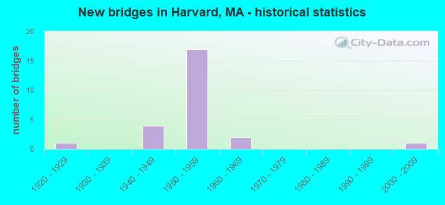
- New bridges - historical statistics
- 11920-1929
- 41940-1949
- 171950-1959
- 21960-1969
- 12000-2009
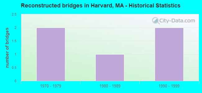
- Reconstructed bridges - Historical Statistics
- 21970-1979
- 11980-1989
- 21990-1999
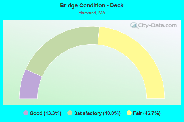
- Bridge Condition - Deck
- 13.3%Good
- 40.0%Satisfactory
- 46.7%Fair
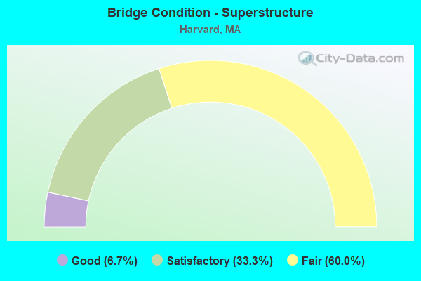
- Bridge Condition - Superstructure
- 6.7%Good
- 33.3%Satisfactory
- 60.0%Fair
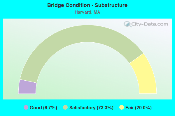
- Bridge Condition - Substructure
- 6.7%Good
- 73.3%Satisfactory
- 20.0%Fair

- Bridge Condition - Channel
- 37.5%Good
- 37.5%Satisfactory
- 12.5%Fair
- 12.5%Poor
Find on map >> Show street view
Structure Number: H090041LPDOTNBI, Location: .5 MI NORTH OF STATE 2 (Lat: 42.529808, Lng: -71.577686), Route carried "on" structure: State highway 110, Year Built: 1925, Status: Open, Structure Length: 0.88m (2.89ft), Average Daily Traffic: 14,987 (year 2019), Truck Traffic: 4%, Average Future Daily Traffic: 34,492 (year 2031), Features Intersected: WATER BOWERS BROOK
Minimum Vertical Clearance: 30+ m (98+ ft), Kilometerpoint: 25.733, Lanes on structure: 2, Base Highway Network: Yes, Owner: State Highway Agency, Approaching Roadway Width: 8.5m (27.9ft), Skew: 4 degrees, Material/Design: Concrete, Design/Construction: Tee Beam, Number Of Spans In Main Unit: 1, Length of Maximum Span: 7.3m (24.0ft), Curb-To-Curb Width: 8.3m (27.2ft), Out-to-Out Width: 9.4m (30.8ft)
Condition: Deck: Fair, Superstructure: Fair, Substructure: Satisfactory, Channel: Poor, Operating Rating: 57.1 metric tons, Method Used To Determine Operating Rating: Allowable Stress (AS), Inventory Rating: 33.8 metric tons, Method Used To Determine Inventory Rating: Allowable Stress (AS), Structural Evaluation: Somewhat better than minimum adequacy, Deck Geometry: High priority of replacement, Waterway Adequacy: Better than present minimum criteria, Approach Roadway Alignment: Better than present minimum criteria, Length Of Structure Improvement: 0.90m (2.95ft), Designated Inspection Frequency: Every 24 months, Underwater Inspection Frequency: Every 36 months, Inspection Date: June 2020, Underwater Inspection Date: August 2019, Bridge Improvement Cost: $333,000, Roadway Improvement Cost: $34,000, Total Project Cost: $500,000 ( Estimate for 2022), Deck Structure Type: Concrete Cast-file-Place, Wearing Surface/Protective System: Wearing Surface: Bituminous, Membrane: Built-up
Find on map >> Show street view
Structure Number: H090081K7MUNNBI, Location: HARVARD-SHIRLEY TL (Lat: 42.551944, Lng: -71.621025), Route carried "on" structure: City street , Year Built: 1948, Year Reconstructed: 1983, Status: Open, Structure Length: 6.77m (22.21ft), Average Daily Traffic: 7,297 (year 2018), Truck Traffic: 6%, Average Future Daily Traffic: 10,739 (year 2032), Design Load: H 20, Features Intersected: WATER NASHUA RIVER, Facility Carried by Structure: HWY FRONT ST
Minimum Vertical Clearance: 30+ m (98+ ft), Kilometerpoint: 0.805, Lanes on structure: 2, Owner: Town or Township Highway Agency, Approaching Roadway Width: 12.2m (40.0ft), Skew: 5 degrees, Material/Design: Steel continuous, Design/Construction: Stringer/Multi-beam, Number Of Spans In Main Unit: 3, Length of Maximum Span: 24.4m (80.1ft), Curb or Sidewalk Widths: Left: 0.7m (2.3ft), Right: 2.2m (7.2ft), Curb-To-Curb Width: 12.2m (40.0ft), Out-to-Out Width: 15.2m (49.9ft)
Condition: Deck: Fair, Superstructure: Fair, Substructure: Satisfactory, Channel: Good, Operating Rating: 50.3 metric tons, Method Used To Determine Operating Rating: Allowable Stress (AS), Inventory Rating: 31.3 metric tons, Method Used To Determine Inventory Rating: Allowable Stress (AS), Structural Evaluation: Somewhat better than minimum adequacy, Deck Geometry: Somewhat better than minimum adequacy, Waterway Adequacy: Better than present minimum criteria, Approach Roadway Alignment: Better than present minimum criteria, Length Of Structure Improvement: 6.80m (22.31ft), Designated Inspection Frequency: Every 24 months, Underwater Inspection Frequency: Every 36 months, Inspection Date: August 2021, Underwater Inspection Date: November 2020, Bridge Improvement Cost: $4,060,000, Roadway Improvement Cost: $407,000, Total Project Cost: $6,091,000 ( Estimate for 2022), Deck Structure Type: Concrete Cast-file-Place, Wearing Surface/Protective System: Wearing Surface: Bituminous, Membrane: Built-up
Find on map >> Show street view
Structure Number: H090091PCDOTNBI, Location: 200 FT. W. OF 110.8 MM (Lat: 42.523797, Lng: -71.554361), Route carried "on" structure: State highway 2, Year Built: 1949, Status: Open, Structure Length: 0.68m (2.23ft), Average Daily Traffic: 55,214 (year 2019), Truck Traffic: 9%, Average Future Daily Traffic: 78,965 (year 2031), Design Load: H 20, Features Intersected: WATER BENNETTS BROOK
Minimum Vertical Clearance: 30+ m (98+ ft), Kilometerpoint: 178.235, Lanes on structure: 4, Base Highway Network: Yes, Owner: State Highway Agency, Approaching Roadway Width: 12.2m (40.0ft), Skew: 35 degrees, Material/Design: Concrete, Design/Construction: Culvert, Number Of Spans In Main Unit: 1, Length of Maximum Span: 6.8m (22.3ft)
Condition: Channel: Good, Culverts: Satisfactory, Operating Rating: 54.1 metric tons, Method Used To Determine Operating Rating: Load Factor (LF), Inventory Rating: 32.4 metric tons, Method Used To Determine Inventory Rating: Load Factor (LF), Structural Evaluation: Equal to present minimum criteria, Waterway Adequacy: Equal to present desirable criteria, Approach Roadway Alignment: Equal to present desirable criteria, Length Of Structure Improvement: 1.60m (5.25ft), Designated Inspection Frequency: Every 24 months, Inspection Date: August 2020, Bridge Improvement Cost: $646,000, Roadway Improvement Cost: $65,000, Total Project Cost: $970,000 ( Estimate for 2022)
Find on map >> Show street view
Structure Number: H090101PDDOTNBI, Location: @ MM 109.8 (Lat: 42.523181, Lng: -71.573133), Route carried "on" structure: State highway 2, Year Built: 1949, Status: Open, Structure Length: 0.66m (2.17ft), Average Daily Traffic: 55,214 (year 2019), Truck Traffic: 9%, Average Future Daily Traffic: 37,035 (year 2031), Design Load: H 20, Features Intersected: WATER BOWERS BROOK
Minimum Vertical Clearance: 30+ m (98+ ft), Kilometerpoint: 177.731, Lanes on structure: 4, Base Highway Network: Yes, Owner: State Highway Agency, Approaching Roadway Width: 17.7m (58.1ft), Skew: 33 degrees, Material/Design: Concrete, Design/Construction: Culvert, Number Of Spans In Main Unit: 1, Length of Maximum Span: 6.6m (21.7ft)
Condition: Channel: Good, Culverts: Satisfactory, Inventory Rating: 27.3 metric tons, Method Used To Determine Inventory Rating: Load Factor (LF), Structural Evaluation: Equal to present minimum criteria, Waterway Adequacy: Equal to present desirable criteria, Approach Roadway Alignment: Equal to present desirable criteria, Length Of Structure Improvement: 2.20m (7.22ft), Designated Inspection Frequency: Every 24 months, Underwater Inspection Frequency: Every 36 months, Inspection Date: August 2020, Underwater Inspection Date: December 2021, Bridge Improvement Cost: $475,000, Roadway Improvement Cost: $48,000, Total Project Cost: $713,000 ( Estimate for 2022)
Find on map >> Show street view
Structure Number: H09011203DOTNBI, Location: 2.9 MI E OF JACKSON RD (Lat: 42.523828, Lng: -71.581772), Route carried "on" structure: State highway 110, Year Built: 1950, Status: Open, Structure Length: 3.08m (10.10ft), Average Daily Traffic: 14,987 (year 2019), Truck Traffic: 6%, Average Future Daily Traffic: 25,585 (year 2032), Design Load: H 20, Features Intersected: ST 2
Minimum Vertical Clearance: 30+ m (98+ ft), Kilometerpoint: 25.733, Lanes on structure: 4, Lanes under structure: 6, Base Highway Network: Yes, Owner: State Highway Agency, Approaching Roadway Width: 15.8m (51.8ft), Skew: 20 degrees, Material/Design: Steel, Design/Construction: Stringer/Multi-beam, Number Of Spans In Main Unit: 2, Length of Maximum Span: 14.3m (46.9ft), Curb or Sidewalk Widths: Left: 0.7m (2.3ft), Right: 1.5m (4.9ft), Curb-To-Curb Width: 15.8m (51.8ft), Out-to-Out Width: 20.2m (66.3ft)
Condition: Deck: Fair, Superstructure: Fair, Substructure: Fair, Operating Rating: 39.7 metric tons, Method Used To Determine Operating Rating: Load Factor (LF), Inventory Rating: 23.6 metric tons, Method Used To Determine Inventory Rating: Load Factor (LF), Structural Evaluation: Somewhat better than minimum adequacy, Deck Geometry: Meets minimum limits, Underclear: High priority of corrective action, Approach Roadway Alignment: Better than present minimum criteria, Length Of Structure Improvement: 3.10m (10.17ft), Designated Inspection Frequency: Every 24 months, Inspection Date: June 2021, Bridge Improvement Cost: $2,460,000, Roadway Improvement Cost: $247,000, Total Project Cost: $3,691,000 ( Estimate for 2022), Deck Structure Type: Concrete Cast-file-Place, Wearing Surface/Protective System: Wearing Surface: Bituminous, Membrane: Built-up
Find on map >> Show street view
Structure Number: H09012219DOTNBI, Location: 0.75 MI E OF ST-110/111 (Lat: 42.522742, Lng: -71.567047), Route carried "on" structure: City street , Year Built: 1950, Year Reconstructed: 1992, Status: Open, Structure Length: 3.29m (10.79ft), Average Daily Traffic: 1,377 (year 2017), Truck Traffic: 1%, Average Future Daily Traffic: 632 (year 2032), Design Load: H 20, Features Intersected: ST 2, Facility Carried by Structure: HWY POOR FARM RD
Minimum Vertical Clearance: 30+ m (98+ ft), Kilometerpoint: 177.340, Lanes on structure: 2, Lanes under structure: 4, Owner: State Highway Agency, Approaching Roadway Width: 10.4m (34.1ft), Skew: 2 degrees, Material/Design: Steel, Design/Construction: Stringer/Multi-beam, Number Of Spans In Main Unit: 2, Length of Maximum Span: 14.0m (45.9ft), Curb or Sidewalk Widths: Left: 0.7m (2.3ft), Right: 1.8m (5.9ft), Curb-To-Curb Width: 10.4m (34.1ft), Out-to-Out Width: 13.0m (42.7ft)
Condition: Deck: Satisfactory, Superstructure: Fair, Substructure: Satisfactory, Operating Rating: 70.8 metric tons, Method Used To Determine Operating Rating: Load Factor (LF), Inventory Rating: 42.4 metric tons, Method Used To Determine Inventory Rating: Load Factor (LF), Structural Evaluation: Somewhat better than minimum adequacy, Deck Geometry: Equal to present minimum criteria, Underclear: High priority of corrective action, Approach Roadway Alignment: Better than present minimum criteria, Length Of Structure Improvement: 3.30m (10.83ft), Designated Inspection Frequency: Every 24 months, Inspection Date: March 2021, Bridge Improvement Cost: $1,686,000, Roadway Improvement Cost: $169,000, Total Project Cost: $2,530,000 ( Estimate for 2022), Deck Structure Type: Concrete Cast-file-Place, Wearing Surface/Protective System: Wearing Surface: Bituminous, Membrane: Built-up
Find on map >> Show street view
Structure Number: H090131LQDOTNBI, Location: 1.5 MI E OF RT 110 (Lat: 42.524469, Lng: -71.550800), Route carried "on" structure: City street , Year Built: 1950, Year Reconstructed: 1990, Status: Open, Structure Length: 5.79m (19.00ft), Average Daily Traffic: 1,172 (year 2019), Truck Traffic: 6%, Average Future Daily Traffic: 1,232 (year 2032), Design Load: H 20, Features Intersected: ST 2, Facility Carried by Structure: HWY LITTLETON RD
Minimum Vertical Clearance: 30+ m (98+ ft), Kilometerpoint: 0.161, Lanes on structure: 2, Lanes under structure: 4, Owner: State Highway Agency, Approaching Roadway Width: 8.5m (27.9ft), Skew: 3 degrees, Material/Design: Steel continuous, Design/Construction: Stringer/Multi-beam, Number Of Spans In Main Unit: 2, Length of Maximum Span: 29.0m (95.1ft), Curb or Sidewalk Widths: Left: 0.0m, Right: 1.5m (4.9ft), Curb-To-Curb Width: 8.5m (27.9ft), Out-to-Out Width: 11.1m (36.4ft)
Condition: Deck: Satisfactory, Superstructure: Satisfactory, Substructure: Fair, Operating Rating: 83.4 metric tons, Method Used To Determine Operating Rating: Load Factor (LF), Inventory Rating: 50.0 metric tons, Method Used To Determine Inventory Rating: Load Factor (LF), Structural Evaluation: Somewhat better than minimum adequacy, Deck Geometry: Somewhat better than minimum adequacy, Underclear: High priority of corrective action, Approach Roadway Alignment: Equal to present minimum criteria, Length Of Structure Improvement: 5.80m (19.03ft), Designated Inspection Frequency: Every 24 months, Inspection Date: April 2021, Bridge Improvement Cost: $2,529,000, Roadway Improvement Cost: $253,000, Total Project Cost: $3,794,000 ( Estimate for 2022), Deck Structure Type: Concrete Cast-file-Place, Wearing Surface/Protective System: Wearing Surface: Bituminous, Membrane: Built-up
Find on map >> Show street view
Structure Number: H09014218DOTNBI, Location: 1.75 MI. W. OF TAYLOR ST. (Lat: 42.527039, Lng: -71.536786), Route carried "on" structure: City street , Year Built: 1950, Year Reconstructed: 1990, Status: Open, Structure Length: 4.30m (14.11ft), Average Daily Traffic: 398 (year 2019), Truck Traffic: 1%, Average Future Daily Traffic: 1,358 (year 2032), Design Load: HS 20, Features Intersected: ST 2, Facility Carried by Structure: HWY OLD LTTLN RD
Minimum Vertical Clearance: 30+ m (98+ ft), Kilometerpoint: 5.150, Lanes on structure: 2, Lanes under structure: 4, Owner: State Highway Agency, Approaching Roadway Width: 10.4m (34.1ft), Skew: 4 degrees, Material/Design: Steel, Design/Construction: Stringer/Multi-beam, Number Of Spans In Main Unit: 2, Length of Maximum Span: 21.0m (68.9ft), Curb or Sidewalk Widths: Left: 0.0m, Right: 1.8m (5.9ft), Curb-To-Curb Width: 10.4m (34.1ft), Out-to-Out Width: 12.9m (42.3ft)
Condition: Deck: Good, Superstructure: Satisfactory, Substructure: Satisfactory, Operating Rating: 64.7 metric tons, Method Used To Determine Operating Rating: Load Factor (LF), Inventory Rating: 38.7 metric tons, Method Used To Determine Inventory Rating: Load Factor (LF), Structural Evaluation: Equal to present minimum criteria, Deck Geometry: Better than present minimum criteria, Underclear: High priority of corrective action, Approach Roadway Alignment: Better than present minimum criteria, Length Of Structure Improvement: 4.40m (14.44ft), Designated Inspection Frequency: Every 24 months, Inspection Date: April 2021, Bridge Improvement Cost: $249,000, Roadway Improvement Cost: $25,000, Total Project Cost: $374,000 ( Estimate for 2022), Deck Structure Type: Concrete Cast-file-Place, Wearing Surface/Protective System: Wearing Surface: Bituminous, Membrane: Built-up
Find on map >> Show street view
Structure Number: H090151PADOTNBI, Location: .1 MI. E. OF JACKSON RD (Lat: 42.520472, Lng: -71.633044), Route carried "on" structure: State highway 2, Year Built: 1953, Status: Open, Structure Length: 5.18m (16.99ft), Average Daily Traffic: 21,787 (year 2020), Truck Traffic: 13%, Average Future Daily Traffic: 69,489 (year 2032), Design Load: H 20, Features Intersected: WATER NASHUA RIVER
Minimum Vertical Clearance: 30+ m (98+ ft), Kilometerpoint: 171.719, Lanes on structure: 2, Base Highway Network: Yes, Owner: State Highway Agency, Approaching Roadway Width: 13.7m (44.9ft), Skew: 22 degrees, Material/Design: Steel, Design/Construction: Stringer/Multi-beam, Number Of Spans In Main Unit: 2, Length of Maximum Span: 25.0m (82.0ft), Curb-To-Curb Width: 13.7m (44.9ft), Out-to-Out Width: 27.1m (88.9ft)
Condition: Deck: Satisfactory, Superstructure: Fair, Substructure: Satisfactory, Channel: Satisfactory, Operating Rating: 49.0 metric tons, Method Used To Determine Operating Rating: Load Factor (LF), Inventory Rating: 29.4 metric tons, Method Used To Determine Inventory Rating: Load Factor (LF), Structural Evaluation: Somewhat better than minimum adequacy, Deck Geometry: Superior to present desirable criteria, Waterway Adequacy: Equal to present desirable criteria, Approach Roadway Alignment: Equal to present desirable criteria, Length Of Structure Improvement: 5.20m (17.06ft), Designated Inspection Frequency: Every 24 months, Underwater Inspection Frequency: Every 36 months, Inspection Date: August 2021, Underwater Inspection Date: March 2021, Bridge Improvement Cost: $5,536,000, Roadway Improvement Cost: $554,000, Total Project Cost: $8,305,000 ( Estimate for 2022), Deck Structure Type: Concrete Cast-file-Place, Wearing Surface/Protective System: Wearing Surface: Bituminous, Membrane: Built-up
Find on map >> Show street view
Structure Number: H090151PBDOTNBI, Location: .1 MI E OF JACKSON RD (Lat: 42.520606, Lng: -71.633119), Route carried "on" structure: State highway 2, Year Built: 1953, Status: Open, Structure Length: 5.18m (16.99ft), Average Daily Traffic: 22,001 (year 2021), Truck Traffic: 13%, Average Future Daily Traffic: 69,489 (year 2032), Design Load: H 20, Features Intersected: WATER NASHUA RIVER
Minimum Vertical Clearance: 30+ m (98+ ft), Kilometerpoint: 171.719, Lanes on structure: 2, Base Highway Network: Yes, Owner: State Highway Agency, Approaching Roadway Width: 13.7m (44.9ft), Skew: 2 degrees, Material/Design: Steel, Design/Construction: Stringer/Multi-beam, Number Of Spans In Main Unit: 2, Length of Maximum Span: 25.0m (82.0ft), Curb or Sidewalk Widths: Left: 0.0m, Right: 0.5m (1.6ft), Curb-To-Curb Width: 13.7m (44.9ft), Out-to-Out Width: 27.1m (88.9ft)
Condition: Deck: Satisfactory, Superstructure: Fair, Substructure: Satisfactory, Channel: Satisfactory, Operating Rating: 49.0 metric tons, Method Used To Determine Operating Rating: Load Factor (LF), Inventory Rating: 29.4 metric tons, Method Used To Determine Inventory Rating: Load Factor (LF), Structural Evaluation: Somewhat better than minimum adequacy, Deck Geometry: Superior to present desirable criteria, Waterway Adequacy: Equal to present desirable criteria, Approach Roadway Alignment: Equal to present desirable criteria, Length Of Structure Improvement: 5.20m (17.06ft), Designated Inspection Frequency: Every 24 months, Underwater Inspection Frequency: Every 36 months, Inspection Date: August 2021, Underwater Inspection Date: March 2021, Bridge Improvement Cost: $5,536,000, Roadway Improvement Cost: $554,000, Total Project Cost: $8,305,000 ( Estimate for 2022), Deck Structure Type: Concrete Cast-file-Place, Wearing Surface/Protective System: Wearing Surface: Bituminous, Membrane: Built-up
Find on map >> Show street view
Structure Number: H090161PGDOTNBI, Location: ST 2 MM 107.8 (Lat: 42.517211, Lng: -71.609025), Route carried "on" structure: State highway 2, Year Built: 1951, Status: Open, Structure Length: 1.16m (3.81ft), Average Daily Traffic: 53,473 (year 2018), Truck Traffic: 12%, Average Future Daily Traffic: 75,806 (year 2031), Design Load: H 20, Features Intersected: HWY TANK RD
Minimum Vertical Clearance: 30+ m (98+ ft), Kilometerpoint: 173.756, Lanes on structure: 4, Lanes under structure: 2, Base Highway Network: Yes, Owner: State Highway Agency, Approaching Roadway Width: 25.6m (84.0ft), Skew: 21 degrees, Material/Design: Steel, Design/Construction: Stringer/Multi-beam, Number Of Spans In Main Unit: 1, Length of Maximum Span: 9.4m (30.8ft), Curb or Sidewalk Widths: Left: 0.5m (1.6ft), Right: 0.5m (1.6ft), Curb-To-Curb Width: 25.6m (84.0ft), Out-to-Out Width: 27.1m (88.9ft)
Condition: Deck: Satisfactory, Superstructure: Fair, Substructure: Satisfactory, Operating Rating: 31.2 metric tons, Method Used To Determine Operating Rating: Load Factor (LF), Inventory Rating: 27.1 metric tons, Method Used To Determine Inventory Rating: Load Factor (LF), Structural Evaluation: Somewhat better than minimum adequacy, Deck Geometry: Superior to present desirable criteria, Underclear: High priority of corrective action, Approach Roadway Alignment: Equal to present desirable criteria, Bridge Posting: Required (Relationship of Operating Rating to Maximum Legal Load: 0.1 - 9.9% below), Length Of Structure Improvement: 1.20m (3.94ft), Designated Inspection Frequency: Every 24 months, Inspection Date: August 2020, Bridge Improvement Cost: $1,278,000, Roadway Improvement Cost: $128,000, Total Project Cost: $1,918,000 ( Estimate for 2022), Deck Structure Type: Concrete Cast-file-Place, Wearing Surface/Protective System: Wearing Surface: Bituminous, Membrane: Built-up
Find on map >> Show street view
Structure Number: H090171PFDOTNBI, Location: 1.25 MI W. OF ST 110 &111 (Lat: 42.517044, Lng: -71.606744), Route carried "on" structure: State highway 2, Year Built: 1951, Status: Open, Structure Length: 1.62m (5.31ft), Average Daily Traffic: 50,904 (year 2014), Truck Traffic: 10%, Average Future Daily Traffic: 67,910 (year 2031), Design Load: H 20, Features Intersected: RR BMRR
Minimum Vertical Clearance: 30+ m (98+ ft), Kilometerpoint: 173.933, Lanes on structure: 4, Base Highway Network: Yes, Owner: State Highway Agency, Approaching Roadway Width: 25.6m (84.0ft), Skew: 33 degrees, Material/Design: Steel, Design/Construction: Stringer/Multi-beam, Number Of Spans In Main Unit: 1, Length of Maximum Span: 14.3m (46.9ft), Curb-To-Curb Width: 25.6m (84.0ft), Out-to-Out Width: 27.1m (88.9ft)
Condition: Deck: Fair, Superstructure: Fair, Substructure: Satisfactory, Operating Rating: 41.6 metric tons, Method Used To Determine Operating Rating: Load Factor (LF), Inventory Rating: 24.9 metric tons, Method Used To Determine Inventory Rating: Load Factor (LF), Structural Evaluation: Somewhat better than minimum adequacy, Deck Geometry: Superior to present desirable criteria, Underclear: High priority of corrective action, Approach Roadway Alignment: Equal to present desirable criteria, Length Of Structure Improvement: 1.70m (5.58ft), Designated Inspection Frequency: Every 24 months, Inspection Date: November 2020, Bridge Improvement Cost: $1,810,000, Roadway Improvement Cost: $182,000, Total Project Cost: $2,716,000 ( Estimate for 2022), Deck Structure Type: Concrete Cast-file-Place, Wearing Surface/Protective System: Wearing Surface: Bituminous, Membrane: Built-up
Find on map >> Show street view
Structure Number: H090181PEDOTNBI, Location: .9 MI. W. OF ST 110&111 (Lat: 42.519478, Lng: -71.598483), Route carried "on" structure: State highway 2, Year Built: 1951, Status: Open, Structure Length: 1.19m (3.90ft), Average Daily Traffic: 52,262 (year 2015), Truck Traffic: 15%, Average Future Daily Traffic: 66,331 (year 2031), Design Load: H 20, Features Intersected: HWY DEPOT ST
Minimum Vertical Clearance: 30+ m (98+ ft), Kilometerpoint: 174.690, Lanes on structure: 4, Lanes under structure: 2, Base Highway Network: Yes, Owner: State Highway Agency, Approaching Roadway Width: 25.6m (84.0ft), Skew: 21 degrees, Material/Design: Steel, Design/Construction: Stringer/Multi-beam, Number Of Spans In Main Unit: 1, Length of Maximum Span: 9.8m (32.2ft), Curb or Sidewalk Widths: Left: 0.5m (1.6ft), Right: 0.5m (1.6ft), Curb-To-Curb Width: 16.2m (53.1ft), Out-to-Out Width: 27.2m (89.2ft)
Condition: Deck: Satisfactory, Superstructure: Satisfactory, Substructure: Good, Operating Rating: 38.4 metric tons, Method Used To Determine Operating Rating: Load Factor (LF), Inventory Rating: 25.7 metric tons, Method Used To Determine Inventory Rating: Load Factor (LF), Structural Evaluation: Equal to present minimum criteria, Deck Geometry: High priority of replacement, Underclear: High priority of corrective action, Approach Roadway Alignment: Equal to present desirable criteria, Length Of Structure Improvement: 1.20m (3.94ft), Designated Inspection Frequency: Every 24 months, Inspection Date: August 2020, Bridge Improvement Cost: $1,283,000, Roadway Improvement Cost: $129,000, Total Project Cost: $1,925,000 ( Estimate for 2022), Deck Structure Type: Concrete Cast-file-Place, Wearing Surface/Protective System: Wearing Surface: Bituminous, Membrane: Built-up
Find on map >> Show street view
Structure Number: H0901923VDOTNBI, Location: .1 MI N OF ST-2 (Lat: 42.521900, Lng: -71.633975), Route carried "on" structure: Other road , Year Built: 1942, Year Reconstructed: 1983, Status: Temporarily open, Structure Length: 3.51m (11.52ft), Average Daily Traffic: 9,200 (year 2012), Truck Traffic: 22%, Average Future Daily Traffic: 14,530 (year 2031), Design Load: H 20, Features Intersected: WATER NASHUA RIVER, Facility Carried by Structure: HWY JACKSON RD
Minimum Vertical Clearance: 30+ m (98+ ft), Kilometerpoint: 0.000, Lanes on structure: 2, Owner: State Highway Agency, Approaching Roadway Width: 7.9m (25.9ft), Material/Design: Steel, Design/Construction: Stringer/Multi-beam, Number Of Spans In Main Unit: 2, Length of Maximum Span: 16.5m (54.1ft), Curb or Sidewalk Widths: Left: 0.6m (2.0ft), Right: 0.6m (2.0ft), Curb-To-Curb Width: 7.9m (25.9ft), Out-to-Out Width: 9.2m (30.2ft)
Condition: Deck: Fair, Superstructure: Satisfactory, Substructure: Fair, Channel: Fair, Operating Rating: 63.4 metric tons, Method Used To Determine Operating Rating: Load Factor (LF), Inventory Rating: 38.0 metric tons, Method Used To Determine Inventory Rating: Load Factor (LF), Structural Evaluation: Somewhat better than minimum adequacy, Deck Geometry: High priority of replacement, Waterway Adequacy: Equal to present desirable criteria, Approach Roadway Alignment: Equal to present minimum criteria, Length Of Structure Improvement: 3.60m (11.81ft), Designated Inspection Frequency: Every 24 months, Underwater Inspection Frequency: Every 36 months, Inspection Date: October 2020, Underwater Inspection Date: March 2021, Bridge Improvement Cost: $1,301,000, Roadway Improvement Cost: $131,000, Total Project Cost: $1,952,000 ( Estimate for 2022), Deck Structure Type: Concrete Cast-file-Place, Wearing Surface/Protective System: Wearing Surface: Bituminous, Membrane: Built-up
Find on map >> Show street view
Structure Number: H090201V6DOTNBI, Location: 3 MI NE ST-117 (Lat: 42.470444, Lng: -71.558075), Route carried "on" structure: Interstate 495, Year Built: 1963, Status: Open, Structure Length: 3.32m (10.89ft), Average Daily Traffic: 47,482 (year 2019), Truck Traffic: 10%, Average Future Daily Traffic: 71,068 (year 2031), Design Load: H 20, Features Intersected: HWY STOW RD
Minimum Vertical Clearance: 30+ m (98+ ft), Kilometerpoint: 118.139, Lanes on structure: 3, Lanes under structure: 2, Base Highway Network: Yes, Owner: State Highway Agency, Approaching Roadway Width: 15.2m (49.9ft), Skew: 1 degrees, Material/Design: Prestressed concrete, Design/Construction: Stringer/Multi-beam, Number Of Spans In Main Unit: 3, Length of Maximum Span: 13.1m (43.0ft), Curb or Sidewalk Widths: Left: 0.5m (1.6ft), Right: 0.5m (1.6ft), Curb-To-Curb Width: 15.2m (49.9ft), Out-to-Out Width: 17.1m (56.1ft)
Condition: Deck: Fair, Superstructure: Fair, Substructure: Satisfactory, Operating Rating: 54.8 metric tons, Method Used To Determine Operating Rating: Load Factor (LF), Inventory Rating: 32.9 metric tons, Method Used To Determine Inventory Rating: Load Factor (LF), Structural Evaluation: Somewhat better than minimum adequacy, Deck Geometry: Meets minimum limits, Underclear: High priority of corrective action, Approach Roadway Alignment: Equal to present desirable criteria, Length Of Structure Improvement: 3.40m (11.15ft), Designated Inspection Frequency: Every 24 months, Inspection Date: November 2020, Bridge Improvement Cost: $2,284,000, Roadway Improvement Cost: $229,000, Total Project Cost: $3,427,000 ( Estimate for 2022), Deck Structure Type: Concrete Cast-file-Place, Wearing Surface/Protective System: Wearing Surface: Bituminous, Membrane: Built-up
Find on map >> Show street view
Structure Number: H090201V7DOTNBI, Location: 3 MI NE ST-117 (Lat: 42.470853, Lng: -71.558575), Route carried "on" structure: Interstate 495, Year Built: 1963, Status: Open, Structure Length: 3.38m (11.09ft), Average Daily Traffic: 45,362 (year 2017), Truck Traffic: 6%, Average Future Daily Traffic: 71,068 (year 2031), Design Load: HS 20+Mod, Features Intersected: HWY STOW RD
Minimum Vertical Clearance: 30+ m (98+ ft), Kilometerpoint: 118.139, Lanes on structure: 3, Lanes under structure: 2, Base Highway Network: Yes, Owner: State Highway Agency, Approaching Roadway Width: 15.2m (49.9ft), Skew: 1 degrees, Material/Design: Prestressed concrete, Design/Construction: Stringer/Multi-beam, Number Of Spans In Main Unit: 3, Length of Maximum Span: 13.0m (42.7ft), Curb or Sidewalk Widths: Left: 0.5m (1.6ft), Right: 0.5m (1.6ft), Curb-To-Curb Width: 15.2m (49.9ft), Out-to-Out Width: 17.1m (56.1ft)
Condition: Deck: Fair, Superstructure: Satisfactory, Substructure: Satisfactory, Operating Rating: 52.2 metric tons, Method Used To Determine Operating Rating: Allowable Stress (AS), Inventory Rating: 32.3 metric tons, Method Used To Determine Inventory Rating: Allowable Stress (AS), Structural Evaluation: Equal to present minimum criteria, Deck Geometry: Meets minimum limits, Underclear: High priority of corrective action, Approach Roadway Alignment: Equal to present desirable criteria, Length Of Structure Improvement: 3.40m (11.15ft), Designated Inspection Frequency: Every 24 months, Inspection Date: November 2020, Bridge Improvement Cost: $2,284,000, Roadway Improvement Cost: $229,000, Total Project Cost: $3,427,000 ( Estimate for 2022), Deck Structure Type: Concrete Cast-file-Place, Wearing Surface/Protective System: Wearing Surface: Bituminous, Membrane: Built-up
Find on map >> Show street view
Structure Number: H090255X4STANBI, Location: 0.6 MI W. OF JACKSON RD. (Lat: 42.541047, Lng: -71.633719), Route carried "on" structure: City street , Year Built: 2008, Status: Open, Structure Length: 7.60m (24.93ft), Average Daily Traffic: 3,120 (year 2012), Truck Traffic: 7%, Average Future Daily Traffic: 4,927 (year 2031), Design Load: HS 25 or greater, Features Intersected: WATER NASHUA RIVER, Facility Carried by Structure: HWY HOSPITAL RD
Minimum Vertical Clearance: 30+ m (98+ ft), Kilometerpoint: 0.996, Lanes on structure: 2, Owner: State Highway Agency, Approaching Roadway Width: 8.0m (26.2ft), Material/Design: Prestressed concrete continuous, Design/Construction: Box Beam or Girders - Single/Spread, Number Of Spans In Main Unit: 3, Length of Maximum Span: 27.0m (88.6ft), Curb or Sidewalk Widths: Left: 1.6m (5.2ft), Right: 0.0m, Curb-To-Curb Width: 8.0m (26.2ft), Out-to-Out Width: 10.5m (34.4ft)
Condition: Deck: Good, Superstructure: Good, Substructure: Satisfactory, Channel: Satisfactory, Operating Rating: 74.9 metric tons, Method Used To Determine Operating Rating: Load Factor (LF), Inventory Rating: 44.7 metric tons, Method Used To Determine Inventory Rating: Load Factor (LF), Structural Evaluation: Equal to present minimum criteria, Deck Geometry: High priority of corrective action, Waterway Adequacy: Superior to present desirable criteria, Approach Roadway Alignment: Better than present minimum criteria, Length Of Structure Improvement: 7.70m (25.26ft), Designated Inspection Frequency: Every 24 months, Underwater Inspection Frequency: Every 36 months, Inspection Date: September 2020, Underwater Inspection Date: October 2019, Bridge Improvement Cost: $3,921,000, Roadway Improvement Cost: $393,000, Total Project Cost: $5,882,000 ( Estimate for 2022), Deck Structure Type: Concrete Cast-file-Place, Wearing Surface/Protective System: Wearing Surface: Bituminous, Deck Protection: Epoxy Coated Reinforcing
Find on map >> Show street view
Structure Number: H09011203DOTNBI, Location: 100 YDS NORTH OF RIVER (Lat: 42.516667, Lng: -71.583333), Route carried "under" structure: State highway 2, Year Built: 1950, Structure Length: 0. m, Average Daily Traffic: 9,900 (year 0000), Features Intersected: ST 2 EB, Facility Carried by Structure: ST110 AYER RD
Minimum Vertical Clearance: 4.47m (14.67ft), Kilometerpoint: 169.105, Lanes on structure: 4, Lanes under structure: 2, Material/Design: Steel, Design/Construction: Stringer/Multi-beam, Length of Maximum Span: 14.3m (46.9ft)
Find on map >> Show street view
Structure Number: H09011203DOTNBI, Location: 100 YARDS NORTH OF RIVER (Lat: 42.516667, Lng: -71.583333), Route carried "under" structure: State highway 2, Year Built: 1950, Structure Length: 0. m, Average Daily Traffic: 31,000 (year 0000), Features Intersected: ST 2 WB, Facility Carried by Structure: ST110 AYER RD
Minimum Vertical Clearance: 4.47m (14.67ft), Kilometerpoint: 0.000, Lanes on structure: 4, Lanes under structure: 2, Material/Design: Steel, Design/Construction: Stringer/Multi-beam, Length of Maximum Span: 14.3m (46.9ft)
Find on map >> Show street view
Structure Number: H09012219DOTNBI, Location: 0.75 MI ELY RT 110/111 (Lat: 42.516667, Lng: -71.566667), Route carried "under" structure: State highway 2, Year Built: 1950, Structure Length: 0. m, Average Daily Traffic: 31,000 (year 0000), Features Intersected: ST 2 EB, Facility Carried by Structure: HWY POOR FARM RD
Minimum Vertical Clearance: 4.32m (14.17ft), Kilometerpoint: 0.000, Lanes on structure: 2, Lanes under structure: 2, Material/Design: Steel, Design/Construction: Stringer/Multi-beam, Length of Maximum Span: 14.6m (47.9ft)
Find on map >> Show street view
Structure Number: H09012219DOTNBI, Location: 0.75 MI ELY RT 110/111 (Lat: 42.516667, Lng: -71.566667), Route carried "under" structure: State highway 2, Year Built: 1950, Structure Length: 0. m, Average Daily Traffic: 31,000 (year 0000), Features Intersected: ST 2 WB, Facility Carried by Structure: HWY POOR FARM RD
Minimum Vertical Clearance: 4.32m (14.17ft), Kilometerpoint: 0.000, Lanes on structure: 2, Lanes under structure: 2, Material/Design: Steel, Design/Construction: Stringer/Multi-beam, Length of Maximum Span: 14.6m (47.9ft)
Find on map >> Show street view
Structure Number: H090131LQDOTNBI, Location: 1.5 MI E RT 2 & RT 110 (Lat: 42.533333, Lng: -71.550000), Route carried "under" structure: State highway 2, Year Built: 1950, Structure Length: 0. m, Average Daily Traffic: 31,400 (year 0000), Features Intersected: ST 2 EB, Facility Carried by Structure: HWY LITTLETON RD
Minimum Vertical Clearance: 4.44m (14.57ft), Kilometerpoint: 0.000, Lanes on structure: 2, Lanes under structure: 2, Material/Design: Steel continuous, Design/Construction: Stringer/Multi-beam, Length of Maximum Span: 14.6m (47.9ft)
Find on map >> Show street view
Structure Number: H090131LQDOTNBI, Location: 1.5 MI E RT 2 & RT 110 (Lat: 42.533333, Lng: -71.550000), Route carried "under" structure: State highway 2, Year Built: 1950, Structure Length: 0. m, Average Daily Traffic: 31,400 (year 0000), Features Intersected: ST 2 WB, Facility Carried by Structure: HWY LITTLETON RD
Minimum Vertical Clearance: 4.44m (14.57ft), Kilometerpoint: 0.000, Lanes on structure: 2, Lanes under structure: 2, Material/Design: Steel continuous, Design/Construction: Stringer/Multi-beam, Length of Maximum Span: 14.6m (47.9ft)
Find on map >> Show street view
Structure Number: H09014218DOTNBI, Location: 2.5 MI ELY RT 110/111 (Lat: 42.533333, Lng: -71.533333), Route carried "under" structure: State highway 2, Year Built: 1950, Structure Length: 0. m, Average Daily Traffic: 31,000 (year 0000), Features Intersected: ST 2 EB, Facility Carried by Structure: HWY OLD LTTLN RD
Minimum Vertical Clearance: 5.92m (19.42ft), Kilometerpoint: 0.000, Lanes on structure: 2, Lanes under structure: 2, Material/Design: Steel, Design/Construction: Stringer/Multi-beam, Length of Maximum Span: 14.9m (48.9ft)
Find on map >> Show street view
Structure Number: H09014218DOTNBI, Location: 2.5 MI ELY RT 110/111 (Lat: 42.533333, Lng: -71.533333), Route carried "under" structure: State highway 2, Year Built: 1950, Structure Length: 0. m, Average Daily Traffic: 31,400 (year 0000), Features Intersected: ST 2 WB, Facility Carried by Structure: HWY OLD LTTLN RD
Minimum Vertical Clearance: 5.92m (19.42ft), Kilometerpoint: 0.000, Lanes on structure: 2, Lanes under structure: 2, Material/Design: Steel, Design/Construction: Stringer/Multi-beam, Length of Maximum Span: 14.9m (48.9ft)