Bridge Statistics for Harvey, Louisiana (LA)
Condition, Traffic, Stress, Structural Evaluation, Project Costs
- National Bridge Inventory (NBI) Statistics
- 41Number of bridges
- 456ft / 139mTotal length
- $447,000Total costs
- 315,701Total average daily traffic
- 2,783Total average daily truck traffic
- National Bridge Inventory (NBI) Registered Bridges for Harvey
- No street view available for this location
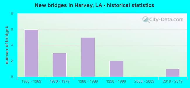
- New bridges - historical statistics
- 61960-1969
- 31970-1979
- 51980-1989
- 21990-1999
- 12010-2019
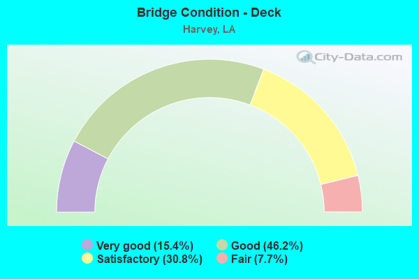
- Bridge Condition - Deck
- 15.4%Very good
- 46.2%Good
- 30.8%Satisfactory
- 7.7%Fair
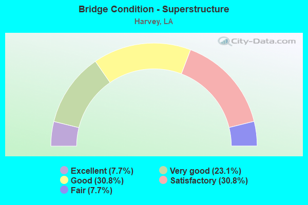
- Bridge Condition - Superstructure
- 7.7%Excellent
- 23.1%Very good
- 30.8%Good
- 30.8%Satisfactory
- 7.7%Fair
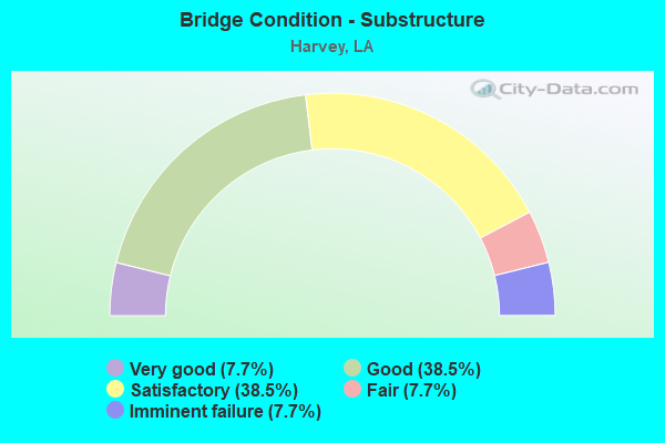
- Bridge Condition - Substructure
- 7.7%Very good
- 38.5%Good
- 38.5%Satisfactory
- 7.7%Fair
- 7.7%Imminent failure
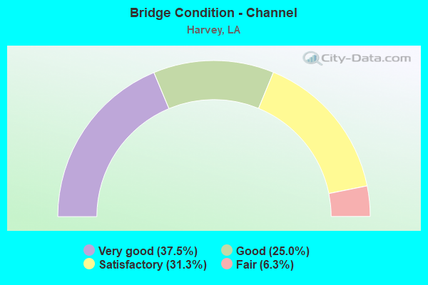
- Bridge Condition - Channel
- 37.5%Very good
- 25.0%Good
- 31.3%Satisfactory
- 6.3%Fair
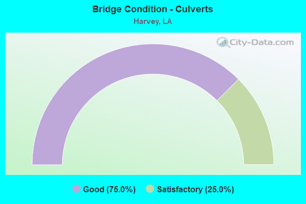
- Bridge Condition - Culverts
- 75.0%Good
- 25.0%Satisfactory
Find on map >> Show street view
Structure Number: 22600000020536, Location: 0.8 MI W OF LA 18 (Lat: 29.903561, Lng: -90.067389), Route carried "on" structure: Ramp US 90, Year Built: 2017, Status: Open, Structure Length: 28.80m (94.49ft), Average Daily Traffic: 7,701 (year 2013), Truck Traffic: 25%, Average Future Daily Traffic: 11,443 (year 2033), Design Load: Greater than HL93, Features Intersected: ON RAMP (RAMP 7)
Minimum Vertical Clearance: 30+ m (98+ ft), Kilometerpoint: 0.000, Lanes on structure: 1, Lanes under structure: 1, Base Highway Network: Yes (Inventory Route: 283-09-C, Subroute: 35), Owner: State Highway Agency, Approaching Roadway Width: 9.8m (32.2ft), Material/Design: Concrete, Design/Construction: Box Beam or Girders - Multiple, Number Of Spans In Main Unit: 5, Number Of Approach Spans: 10, Length of Maximum Span: 38.7m (127.0ft), Curb-To-Curb Width: 7.8m (25.6ft), Out-to-Out Width: 8.4m (27.6ft)
Condition: Deck: Good, Superstructure: Excellent, Substructure: Good, Operating Rating: 60.3 metric tons, Method Used To Determine Operating Rating: Load and Resistance Factor Rating (LRFR) rating reported by rating factor(RF) method using HL-93 loadings, Inventory Rating: 45.0 metric tons, Method Used To Determine Inventory Rating: Load and Resistance Factor Rating (LRFR) rating reported by rating factor(RF) method using HL-93 loadings, Structural Evaluation: Better than present minimum criteria, Deck Geometry: Better than present minimum criteria, Underclear: Somewhat better than minimum adequacy, Approach Roadway Alignment: Equal to present desirable criteria, Designated Inspection Frequency: Every 24 months, Inspection Date: December 2020, Deck Structure Type: Concrete Cast-file-Place
Find on map >> Show street view
Structure Number: 22629506900211, Location: 0.01 MI. E. OF LA. 3017 (Lat: 29.839089, Lng: -90.053019), Route carried "on" structure: County highway , Year Built: 1960, Status: Closed, Structure Length: 2.90m (9.51ft), Average Daily Traffic: 2,000 (year 1989), Average Future Daily Traffic: 3,400 (year 2036), Design Load: HS 20, Features Intersected: MURPHY CANAL, Facility Carried by Structure: BAYOU RD
Minimum Vertical Clearance: 30+ m (98+ ft), Kilometerpoint: 0.000, Lanes on structure: 2, Owner: County Highway Agency, Approaching Roadway Width: 4.9m (16.1ft), Material/Design: Concrete, Design/Construction: Slab, Number Of Spans In Main Unit: 5, Length of Maximum Span: 5.8m (19.0ft), Curb-To-Curb Width: 6.2m (20.3ft), Out-to-Out Width: 7.1m (23.3ft)
Condition: Deck: Fair, Superstructure: Fair, Substructure: Imminent failure, Channel: Satisfactory, Operating Rating: 19.1 metric tons, Method Used To Determine Operating Rating: Load and Resistance Factor Rating (LRFR) rating reported by rating factor(RF) method using HL-93 loadings, Inventory Rating: 14.9 metric tons, Method Used To Determine Inventory Rating: Load and Resistance Factor Rating (LRFR) rating reported by rating factor(RF) method using HL-93 loadings, Waterway Adequacy: Equal to present desirable criteria, Approach Roadway Alignment: Equal to present minimum criteria, Bridge Posting: Required (Relationship of Operating Rating to Maximum Legal Load: 30.0 - 39.9% below), Length Of Structure Improvement: 3.72m (12.20ft), Designated Inspection Frequency: Every 24 months, Underwater Inspection Frequency: Every 60 months, Other Special Inspection Frequency: Every 6 months, Inspection Date: Febuary 2021, Underwater Inspection Date: March 2019, Other Special Inspection Date: November 2021, Bridge Improvement Cost: $222,000, Total Project Cost: $333,000 ( Estimate for 2016), Deck Structure Type: Concrete Precast Panels, Wearing Surface/Protective System: Wearing Surface: Monolithic Concrete
Find on map >> Show street view
Structure Number: 22629518900421, Location: 3.1 MI.W.OF BELLCHAS (Lat: 29.870089, Lng: -90.073739), Route carried "on" structure: County highway , Year Built: 1972, Status: Posted for load, Structure Length: 81.08m (266.01ft), Average Daily Traffic: 60,000 (year 1989), Average Future Daily Traffic: 102,000 (year 2036), Design Load: HS 20, Features Intersected: HARVEY CANAL, Facility Carried by Structure: Lapalco BLVD
Minimum Vertical Clearance: 30+ m (98+ ft), Kilometerpoint: 0.000, Lanes on structure: 4, Lanes under structure: 2, Owner: County Highway Agency, Approaching Roadway Width: 21.3m (69.9ft), Skew: 30 degrees, Navigation Control: Yes ( Vertical Clearance: 13.7m (44.9ft), Horizontal Clearance: 45.4m (149.0ft)), Material/Design: Steel, Design/Construction: Movable - Bascule, Number Of Spans In Main Unit: 34, Length of Maximum Span: 76.2m (250.0ft), Curb or Sidewalk Widths: Left: 1.2m (3.9ft), Right: 1.2m (3.9ft), Curb-To-Curb Width: 15.5m (50.9ft), Out-to-Out Width: 21.3m (69.9ft)
Condition: Deck: Satisfactory, Superstructure: Satisfactory, Substructure: Satisfactory, Channel: Good, Operating Rating: 21.2 metric tons, Method Used To Determine Operating Rating: Load Factor (LF), Inventory Rating: 15.5 metric tons, Method Used To Determine Inventory Rating: Load Factor (LF), Structural Evaluation: High priority of corrective action, Deck Geometry: Meets minimum limits, Underclear: Somewhat better than minimum adequacy, Waterway Adequacy: Better than present minimum criteria, Approach Roadway Alignment: Somewhat better than minimum adequacy, Designated Inspection Frequency: Every 24 months, Critical Feature Inspection Frequency: Every 24 months, Underwater Inspection Frequency: Every 60 months, Inspection Date: September 2021, Critical Feature Inspection Date: September 2021, Underwater Inspection Date: March 2019, Deck Structure Type: Concrete Cast-file-Place, Wearing Surface/Protective System: Wearing Surface: Monolithic Concrete
Find on map >> Show street view
Structure Number: 22629519900121, Location: 0.45 MI. E. OF MANHATTAN (Lat: 29.861189, Lng: -90.039661), Route carried "on" structure: County highway , Year Built: 1984, Status: Open, Structure Length: 5.21m (17.09ft), Average Daily Traffic: 6,000 (year 1989), Average Future Daily Traffic: 10,200 (year 2036), Design Load: HS 20, Features Intersected: TRAPP CANAL, Facility Carried by Structure: HARVEY BLVD
Minimum Vertical Clearance: 30+ m (98+ ft), Kilometerpoint: 0.000, Lanes on structure: 2, Owner: County Highway Agency, Approaching Roadway Width: 9.1m (29.9ft), Material/Design: Concrete, Design/Construction: Slab, Number Of Spans In Main Unit: 9, Length of Maximum Span: 5.8m (19.0ft), Curb or Sidewalk Widths: Left: 0.0m, Right: 1.2m (3.9ft), Curb-To-Curb Width: 8.8m (28.9ft), Out-to-Out Width: 10.7m (35.1ft)
Condition: Deck: Good, Superstructure: Good, Substructure: Satisfactory, Channel: Satisfactory, Operating Rating: 57.7 metric tons, Method Used To Determine Operating Rating: Load and Resistance Factor Rating (LRFR) rating reported by rating factor(RF) method using HL-93 loadings, Inventory Rating: 44.4 metric tons, Method Used To Determine Inventory Rating: Load and Resistance Factor Rating (LRFR) rating reported by rating factor(RF) method using HL-93 loadings, Structural Evaluation: Equal to present minimum criteria, Deck Geometry: High priority of replacement, Waterway Adequacy: Equal to present desirable criteria, Approach Roadway Alignment: Better than present minimum criteria, Designated Inspection Frequency: Every 24 months, Underwater Inspection Frequency: Every 60 months, Inspection Date: Febuary 2021, Underwater Inspection Date: March 2019, Deck Structure Type: Concrete Precast Panels, Wearing Surface/Protective System: Wearing Surface: Monolithic Concrete
Find on map >> Show street view
Structure Number: 22629520900411, Location: 0.5 MI S. OF LAPALCO BLVD (Lat: 29.868900, Lng: -90.048211), Route carried "on" structure: County highway , Year Built: 1988, Status: Open, Structure Length: 2.32m (7.61ft), Average Daily Traffic: 2,000 (year 1988), Average Future Daily Traffic: 3,400 (year 2036), Design Load: HS 20, Features Intersected: BAYOU FATMA, Facility Carried by Structure: MANHATTAN BLVD
Minimum Vertical Clearance: 30+ m (98+ ft), Kilometerpoint: 0.000, Lanes on structure: 2, Owner: County Highway Agency, Approaching Roadway Width: 6.7m (22.0ft), Skew: 1 degrees, Material/Design: Concrete, Design/Construction: Slab, Number Of Spans In Main Unit: 4, Length of Maximum Span: 5.8m (19.0ft), Curb-To-Curb Width: 8.5m (27.9ft), Out-to-Out Width: 9.8m (32.2ft)
Condition: Deck: Satisfactory, Superstructure: Satisfactory, Substructure: Satisfactory, Channel: Fair, Operating Rating: 57.7 metric tons, Method Used To Determine Operating Rating: Load and Resistance Factor Rating (LRFR) rating reported by rating factor(RF) method using HL-93 loadings, Inventory Rating: 44.4 metric tons, Method Used To Determine Inventory Rating: Load and Resistance Factor Rating (LRFR) rating reported by rating factor(RF) method using HL-93 loadings, Structural Evaluation: Equal to present minimum criteria, Deck Geometry: High priority of corrective action, Waterway Adequacy: Better than present minimum criteria, Approach Roadway Alignment: Better than present minimum criteria, Designated Inspection Frequency: Every 24 months, Inspection Date: Febuary 2021, Deck Structure Type: Concrete Precast Panels, Wearing Surface/Protective System: Wearing Surface: Monolithic Concrete
Find on map >> Show street view
Structure Number: 22629520900412, Location: 0.5 M S OF LAPALCO BLVD (Lat: 29.869161, Lng: -90.048339), Route carried "on" structure: County highway , Year Built: 1990, Status: Open, Structure Length: 2.32m (7.61ft), Average Daily Traffic: 9,700 (year 1989), Average Future Daily Traffic: 16,490 (year 2036), Design Load: HS 20, Features Intersected: BAYOU FATMA, Facility Carried by Structure: MANHATTAN BLVD
Minimum Vertical Clearance: 30+ m (98+ ft), Kilometerpoint: 0.000, Lanes on structure: 2, Owner: County Highway Agency, Approaching Roadway Width: 9.8m (32.2ft), Skew: 10 degrees, Material/Design: Concrete, Design/Construction: Slab, Number Of Spans In Main Unit: 4, Length of Maximum Span: 5.8m (19.0ft), Curb or Sidewalk Widths: Left: 0.9m (3.0ft), Right: 0.0m, Curb-To-Curb Width: 8.6m (28.2ft), Out-to-Out Width: 10.6m (34.8ft)
Condition: Deck: Good, Superstructure: Good, Substructure: Good, Channel: Satisfactory, Operating Rating: 55.4 metric tons, Method Used To Determine Operating Rating: Load and Resistance Factor Rating (LRFR) rating reported by rating factor(RF) method using HL-93 loadings, Inventory Rating: 42.8 metric tons, Method Used To Determine Inventory Rating: Load and Resistance Factor Rating (LRFR) rating reported by rating factor(RF) method using HL-93 loadings, Structural Evaluation: Better than present minimum criteria, Deck Geometry: High priority of corrective action, Waterway Adequacy: Equal to present desirable criteria, Approach Roadway Alignment: Better than present minimum criteria, Designated Inspection Frequency: Every 24 months, Inspection Date: Febuary 2021, Deck Structure Type: Concrete Precast Panels, Wearing Surface/Protective System: Wearing Surface: Monolithic Concrete
Find on map >> Show street view
Structure Number: 22629521900521, Location: 0.6 MI E OF LA 45 (Lat: 29.867800, Lng: -90.087150), Route carried "on" structure: County highway , Year Built: 1996, Status: Open, Structure Length: 1.31m (4.30ft), Design Load: HS 20, Features Intersected: COUSINS CANAL, Facility Carried by Structure: COUSINS BLVD
Minimum Vertical Clearance: 30+ m (98+ ft), Kilometerpoint: 0.000, Lanes on structure: 2, Owner: County Highway Agency, Approaching Roadway Width: 12.2m (40.0ft), Material/Design: Concrete, Design/Construction: Culvert, Number Of Spans In Main Unit: 4, Length of Maximum Span: 3.0m (9.8ft), Curb-To-Curb Width: 13.3m (43.6ft), Out-to-Out Width: 29.0m (95.1ft)
Condition: Channel: Very good, Culverts: Good, Operating Rating: 42.1 metric tons, Method Used To Determine Operating Rating: Load and Resistance Factor Rating (LRFR) rating reported by rating factor(RF) method using HL-93 loadings, Inventory Rating: 32.4 metric tons, Method Used To Determine Inventory Rating: Load and Resistance Factor Rating (LRFR) rating reported by rating factor(RF) method using HL-93 loadings, Structural Evaluation: Better than present minimum criteria, Deck Geometry: Superior to present desirable criteria, Waterway Adequacy: Better than present minimum criteria, Approach Roadway Alignment: Equal to present minimum criteria, Designated Inspection Frequency: Every 24 months, Inspection Date: January 2021, Deck Structure Type: Concrete Cast-file-Place
Find on map >> Show street view
Structure Number: 22629524900322, Location: 0.4 MI. W. OF MANHAT (Lat: 29.873331, Lng: -90.053300), Route carried "on" structure: County highway , Year Built: 1960, Status: Open, Structure Length: 1.74m (5.71ft), Average Daily Traffic: 2,000 (year 1979), Average Future Daily Traffic: 3,400 (year 2036), Design Load: HS 20, Features Intersected: BAYOU FATMA, Facility Carried by Structure: LAPALCO BLVD
Minimum Vertical Clearance: 30+ m (98+ ft), Kilometerpoint: 0.000, Lanes on structure: 2, Owner: County Highway Agency, Approaching Roadway Width: 12.8m (42.0ft), Material/Design: Concrete, Design/Construction: Slab, Number Of Spans In Main Unit: 3, Length of Maximum Span: 5.8m (19.0ft), Curb-To-Curb Width: 12.3m (40.4ft), Out-to-Out Width: 14.2m (46.6ft)
Condition: Deck: Good, Superstructure: Good, Substructure: Satisfactory, Channel: Satisfactory, Operating Rating: 40.5 metric tons, Method Used To Determine Operating Rating: Load and Resistance Factor Rating (LRFR) rating reported by rating factor(RF) method using HL-93 loadings, Inventory Rating: 31.1 metric tons, Method Used To Determine Inventory Rating: Load and Resistance Factor Rating (LRFR) rating reported by rating factor(RF) method using HL-93 loadings, Structural Evaluation: Equal to present minimum criteria, Deck Geometry: Better than present minimum criteria, Waterway Adequacy: Equal to present minimum criteria, Approach Roadway Alignment: Equal to present minimum criteria, Designated Inspection Frequency: Every 24 months, Inspection Date: January 2021, Deck Structure Type: Concrete Precast Panels, Wearing Surface/Protective System: Wearing Surface: Bituminous
Find on map >> Show street view
Structure Number: 22629524900361, Location: O.1 MI.N. OF LAPALCO BLVD (Lat: 29.874689, Lng: -90.058450), Route carried "on" structure: County highway , Year Built: 1970, Status: Open, Structure Length: 0.67m (2.20ft), Average Daily Traffic: 3,000 (year 1979), Average Future Daily Traffic: 5,100 (year 2036), Design Load: HS 20, Features Intersected: BAYOU FATMA, Facility Carried by Structure: BROOKLYN AVE
Minimum Vertical Clearance: 30+ m (98+ ft), Kilometerpoint: 0.000, Lanes on structure: 2, Owner: County Highway Agency, Approaching Roadway Width: 7.6m (24.9ft), Material/Design: Steel, Design/Construction: Culvert, Number Of Spans In Main Unit: 2, Length of Maximum Span: 3.0m (9.8ft), Curb or Sidewalk Widths: Left: 1.2m (3.9ft), Right: 1.2m (3.9ft), Curb-To-Curb Width: 7.6m (24.9ft), Out-to-Out Width: 16.8m (55.1ft)
Condition: Channel: Very good, Culverts: Good, Operating Rating: 39.2 metric tons, Method Used To Determine Operating Rating: Load and Resistance Factor Rating (LRFR) rating reported by rating factor(RF) method using HL-93 loadings, Inventory Rating: 30.1 metric tons, Method Used To Determine Inventory Rating: Load and Resistance Factor Rating (LRFR) rating reported by rating factor(RF) method using HL-93 loadings, Structural Evaluation: Better than present minimum criteria, Deck Geometry: High priority of replacement, Waterway Adequacy: Better than present minimum criteria, Approach Roadway Alignment: Equal to present minimum criteria, Length Of Structure Improvement: 1.28m (4.20ft), Designated Inspection Frequency: Every 24 months, Inspection Date: January 2021, Bridge Improvement Cost: $76,000, Total Project Cost: $114,000 ( Estimate for 2016)
Find on map >> Show street view
Structure Number: 22629524900381, Location: 0.9MI.W.OF MANHATTAN (Lat: 29.872681, Lng: -90.064061), Route carried "on" structure: County highway , Year Built: 1976, Status: Open, Structure Length: 2.41m (7.91ft), Average Daily Traffic: 20,000 (year 1979), Average Future Daily Traffic: 34,000 (year 2036), Design Load: HS 20, Features Intersected: MURPHY CANAL, Facility Carried by Structure: Lapalco BLVD
Minimum Vertical Clearance: 30+ m (98+ ft), Kilometerpoint: 0.000, Lanes on structure: 5, Owner: County Highway Agency, Approaching Roadway Width: 25.0m (82.0ft), Skew: 30 degrees, Material/Design: Concrete, Design/Construction: Slab, Number Of Spans In Main Unit: 3, Length of Maximum Span: 7.9m (25.9ft), Curb or Sidewalk Widths: Left: 0.9m (3.0ft), Right: 1.0m (3.3ft), Curb-To-Curb Width: 21.4m (70.2ft), Out-to-Out Width: 24.5m (80.4ft)
Condition: Deck: Satisfactory, Superstructure: Satisfactory, Substructure: Good, Channel: Good, Operating Rating: 42.4 metric tons, Method Used To Determine Operating Rating: Load and Resistance Factor Rating (LRFR) rating reported by rating factor(RF) method using HL-93 loadings, Inventory Rating: 32.7 metric tons, Method Used To Determine Inventory Rating: Load and Resistance Factor Rating (LRFR) rating reported by rating factor(RF) method using HL-93 loadings, Structural Evaluation: Equal to present minimum criteria, Deck Geometry: Somewhat better than minimum adequacy, Waterway Adequacy: Equal to present minimum criteria, Approach Roadway Alignment: Somewhat better than minimum adequacy, Designated Inspection Frequency: Every 24 months, Inspection Date: January 2021, Deck Structure Type: Concrete Cast-file-Place, Wearing Surface/Protective System: Wearing Surface: Monolithic Concrete
Find on map >> Show street view
Structure Number: 22629524900391, Location: 0.3 MI.E OF PETERS R (Lat: 29.874081, Lng: -90.064669), Route carried "on" structure: County highway , Year Built: 1960, Status: Open, Structure Length: 3.47m (11.38ft), Average Daily Traffic: 750 (year 1979), Average Future Daily Traffic: 1,275 (year 2036), Design Load: HS 20, Features Intersected: GARDERE CANAL, Facility Carried by Structure: BREAUX AVE
Minimum Vertical Clearance: 30+ m (98+ ft), Kilometerpoint: 0.000, Lanes on structure: 2, Owner: County Highway Agency, Approaching Roadway Width: 9.1m (29.9ft), Material/Design: Concrete, Design/Construction: Slab, Number Of Spans In Main Unit: 6, Length of Maximum Span: 5.8m (19.0ft), Curb-To-Curb Width: 7.4m (24.3ft), Out-to-Out Width: 9.1m (29.9ft)
Condition: Deck: Good, Superstructure: Good, Substructure: Fair, Channel: Very good, Operating Rating: 23.7 metric tons, Method Used To Determine Operating Rating: Load and Resistance Factor Rating (LRFR) rating reported by rating factor(RF) method using HL-93 loadings, Inventory Rating: 18.5 metric tons, Method Used To Determine Inventory Rating: Load and Resistance Factor Rating (LRFR) rating reported by rating factor(RF) method using HL-93 loadings, Structural Evaluation: Somewhat better than minimum adequacy, Deck Geometry: Meets minimum limits, Waterway Adequacy: Better than present minimum criteria, Approach Roadway Alignment: Better than present minimum criteria, Designated Inspection Frequency: Every 24 months, Inspection Date: Febuary 2021, Deck Structure Type: Concrete Cast-file-Place, Wearing Surface/Protective System: Wearing Surface: Bituminous
Find on map >> Show street view
Structure Number: 22629528900212, Location: 0.1MI.W.OF WALL BLVD (Lat: 29.879419, Lng: -90.034131), Route carried "on" structure: County highway , Year Built: 1960, Status: Open, Structure Length: 1.74m (5.71ft), Average Daily Traffic: 5,000 (year 1979), Average Future Daily Traffic: 8,500 (year 2036), Design Load: HS 20, Features Intersected: FORTADO CANAL, Facility Carried by Structure: LAPALCO BLVD
Minimum Vertical Clearance: 30+ m (98+ ft), Kilometerpoint: 0.000, Lanes on structure: 3, Owner: County Highway Agency, Approaching Roadway Width: 12.2m (40.0ft), Material/Design: Concrete, Design/Construction: Slab, Number Of Spans In Main Unit: 3, Length of Maximum Span: 5.8m (19.0ft), Curb or Sidewalk Widths: Left: 0.9m (3.0ft), Right: 0.0m, Curb-To-Curb Width: 12.3m (40.4ft), Out-to-Out Width: 14.3m (46.9ft)
Condition: Deck: Satisfactory, Superstructure: Satisfactory, Substructure: Satisfactory, Channel: Very good, Operating Rating: 32.4 metric tons, Method Used To Determine Operating Rating: Load and Resistance Factor Rating (LRFR) rating reported by rating factor(RF) method using HL-93 loadings, Inventory Rating: 24.9 metric tons, Method Used To Determine Inventory Rating: Load and Resistance Factor Rating (LRFR) rating reported by rating factor(RF) method using HL-93 loadings, Structural Evaluation: Equal to present minimum criteria, Deck Geometry: Meets minimum limits, Waterway Adequacy: Better than present minimum criteria, Approach Roadway Alignment: Equal to present minimum criteria, Designated Inspection Frequency: Every 24 months, Inspection Date: January 2021, Deck Structure Type: Concrete Precast Panels, Wearing Surface/Protective System: Wearing Surface: Bituminous
Find on map >> Show street view
Structure Number: 22629528900511, Location: 1 MI E. OF BARATARIA BLVD (Lat: 29.881789, Lng: -90.083161), Route carried "on" structure: County highway , Year Built: 1984, Status: Open, Structure Length: 1.04m (3.41ft), Average Daily Traffic: 450 (year 1980), Average Future Daily Traffic: 765 (year 2036), Design Load: HS 20, Features Intersected: SWIFT CANAL, Facility Carried by Structure: PATRIOT ST
Minimum Vertical Clearance: 30+ m (98+ ft), Kilometerpoint: 0.000, Lanes on structure: 2, Owner: County Highway Agency, Approaching Roadway Width: 6.4m (21.0ft), Material/Design: Prestressed concrete, Design/Construction: Stringer/Multi-beam, Number Of Spans In Main Unit: 1, Length of Maximum Span: 10.4m (34.1ft), Curb or Sidewalk Widths: Left: 0.9m (3.0ft), Right: 0.0m, Curb-To-Curb Width: 6.6m (21.7ft), Out-to-Out Width: 11.9m (39.0ft)
Condition: Deck: Good, Superstructure: Very good, Substructure: Good, Channel: Very good, Operating Rating: 37.6 metric tons, Method Used To Determine Operating Rating: Load and Resistance Factor Rating (LRFR) rating reported by rating factor(RF) method using HL-93 loadings, Inventory Rating: 28.5 metric tons, Method Used To Determine Inventory Rating: Load and Resistance Factor Rating (LRFR) rating reported by rating factor(RF) method using HL-93 loadings, Structural Evaluation: Better than present minimum criteria, Deck Geometry: High priority of corrective action, Waterway Adequacy: Equal to present desirable criteria, Approach Roadway Alignment: Equal to present minimum criteria, Designated Inspection Frequency: Every 24 months, Inspection Date: Febuary 2021, Deck Structure Type: Concrete Cast-file-Place
Find on map >> Show street view
Structure Number: 22629529900142, Location: 0.1MI.W OF BELLCHASE (Lat: 29.881350, Lng: -90.023939), Route carried "on" structure: County highway , Year Built: 1960, Status: Open, Structure Length: 0.91m (2.99ft), Average Daily Traffic: 20,000 (year 1979), Average Future Daily Traffic: 34,000 (year 2036), Design Load: HS 20, Features Intersected: OAKWOOD CANAL, Facility Carried by Structure: LAPALCO BLVD
Minimum Vertical Clearance: 30+ m (98+ ft), Kilometerpoint: 0.000, Lanes on structure: 2, Owner: County Highway Agency, Approaching Roadway Width: 12.2m (40.0ft), Material/Design: Concrete, Design/Construction: Tee Beam, Number Of Spans In Main Unit: 1, Length of Maximum Span: 9.1m (29.9ft), Curb-To-Curb Width: 12.5m (41.0ft), Out-to-Out Width: 14.3m (46.9ft)
Condition: Deck: Very good, Superstructure: Very good, Substructure: Good, Channel: Good, Operating Rating: 32.1 metric tons, Method Used To Determine Operating Rating: Load and Resistance Factor Rating (LRFR) rating reported by rating factor(RF) method using HL-93 loadings, Inventory Rating: 23.7 metric tons, Method Used To Determine Inventory Rating: Load and Resistance Factor Rating (LRFR) rating reported by rating factor(RF) method using HL-93 loadings, Structural Evaluation: Somewhat better than minimum adequacy, Deck Geometry: Better than present minimum criteria, Waterway Adequacy: Better than present minimum criteria, Approach Roadway Alignment: Equal to present minimum criteria, Designated Inspection Frequency: Every 24 months, Inspection Date: January 2021, Deck Structure Type: Concrete Precast Panels, Wearing Surface/Protective System: Wearing Surface: Bituminous
Find on map >> Show street view
Structure Number: 22629530900331, Location: 0.1 MI. EAST OF MANHATTAN (Lat: 29.879331, Lng: -90.053319), Route carried "on" structure: County highway , Year Built: 1985, Status: Open, Structure Length: 1.25m (4.10ft), Average Daily Traffic: 500 (year 1980), Average Future Daily Traffic: 850 (year 2036), Design Load: HS 20, Features Intersected: 3 MILE CANAL, Facility Carried by Structure: 11TH ST
Minimum Vertical Clearance: 30+ m (98+ ft), Kilometerpoint: 0.000, Lanes on structure: 2, Owner: County Highway Agency, Approaching Roadway Width: 8.5m (27.9ft), Skew: 2 degrees, Material/Design: Prestressed concrete, Design/Construction: Stringer/Multi-beam, Number Of Spans In Main Unit: 1, Length of Maximum Span: 12.5m (41.0ft), Curb or Sidewalk Widths: Left: 1.2m (3.9ft), Right: 1.1m (3.6ft), Curb-To-Curb Width: 8.5m (27.9ft), Out-to-Out Width: 13.1m (43.0ft)
Condition: Deck: Very good, Superstructure: Very good, Substructure: Very good, Channel: Satisfactory, Operating Rating: 58.3 metric tons, Method Used To Determine Operating Rating: Load and Resistance Factor Rating (LRFR) rating reported by rating factor(RF) method using HL-93 loadings, Inventory Rating: 36.3 metric tons, Method Used To Determine Inventory Rating: Load and Resistance Factor Rating (LRFR) rating reported by rating factor(RF) method using HL-93 loadings, Structural Evaluation: Equal to present desirable criteria, Deck Geometry: Somewhat better than minimum adequacy, Waterway Adequacy: Better than present minimum criteria, Approach Roadway Alignment: Equal to present minimum criteria, Designated Inspection Frequency: Every 24 months, Inspection Date: January 2021, Deck Structure Type: Concrete Cast-file-Place, Wearing Surface/Protective System: Wearing Surface: Monolithic Concrete
Find on map >> Show street view
Structure Number: 22629531900311, Location: 0.6 MI N OF LAPALCO BLVD (Lat: 29.883081, Lng: -90.052989), Route carried "on" structure: County highway , Year Built: 1964, Status: Open, Structure Length: 1.46m (4.79ft), Average Daily Traffic: 2,000 (year 1979), Average Future Daily Traffic: 3,400 (year 2036), Design Load: HS 20, Features Intersected: THREE MILE CANAL, Facility Carried by Structure: MANHATTAN BLVD
Minimum Vertical Clearance: 30+ m (98+ ft), Kilometerpoint: 0.000, Lanes on structure: 4, Owner: County Highway Agency, Approaching Roadway Width: 7.3m (24.0ft), Skew: 34 degrees, Material/Design: Steel, Design/Construction: Culvert, Number Of Spans In Main Unit: 3, Length of Maximum Span: 1.8m (5.9ft)
Condition: Channel: Good, Culverts: Good, Operating Rating: 97.2 metric tons, Method Used To Determine Operating Rating: Load and Resistance Factor Rating (LRFR) rating reported by rating factor(RF) method using HL-93 loadings, Inventory Rating: 74.5 metric tons, Method Used To Determine Inventory Rating: Load and Resistance Factor Rating (LRFR) rating reported by rating factor(RF) method using HL-93 loadings, Structural Evaluation: Better than present minimum criteria, Waterway Adequacy: Somewhat better than minimum adequacy, Approach Roadway Alignment: Better than present minimum criteria, Designated Inspection Frequency: Every 24 months, Inspection Date: January 2021
Find on map >> Show street view
Structure Number: 22629538900411, Location: 0.3 MI. S. OF W.B. EXPRWY (Lat: 29.896061, Lng: -90.067550), Route carried "on" structure: County highway , Year Built: 1983, Status: Open, Structure Length: 0.73m (2.40ft), Average Daily Traffic: 1,000 (year 1980), Average Future Daily Traffic: 1,700 (year 2036), Design Load: HS 20, Features Intersected: GARDERE CANAL, Facility Carried by Structure: Napolean Dr
Minimum Vertical Clearance: 30+ m (98+ ft), Kilometerpoint: 0.000, Lanes on structure: 2, Owner: County Highway Agency, Approaching Roadway Width: 7.3m (24.0ft), Skew: 34 degrees, Material/Design: Concrete, Design/Construction: Culvert, Number Of Spans In Main Unit: 2, Length of Maximum Span: 3.7m (12.1ft), Curb or Sidewalk Widths: Left: 1.2m (3.9ft), Right: 1.2m (3.9ft), Curb-To-Curb Width: 9.0m (29.5ft), Out-to-Out Width: 12.6m (41.3ft)
Condition: Channel: Very good, Culverts: Satisfactory, Operating Rating: 32.4 metric tons, Method Used To Determine Operating Rating: Load and Resistance Factor Rating (LRFR) rating reported by rating factor(RF) method using HL-93 loadings, Inventory Rating: 24.9 metric tons, Method Used To Determine Inventory Rating: Load and Resistance Factor Rating (LRFR) rating reported by rating factor(RF) method using HL-93 loadings, Structural Evaluation: Equal to present minimum criteria, Deck Geometry: Somewhat better than minimum adequacy, Waterway Adequacy: Equal to present minimum criteria, Approach Roadway Alignment: Better than present minimum criteria, Designated Inspection Frequency: Every 24 months, Inspection Date: January 2021, Deck Structure Type: Concrete Cast-file-Place
Find on map >> Show street view
Structure Number: 22600000020536, Location: .08 MI. W. OF MANHATTEN (Lat: 29.903219, Lng: -90.067961), Route carried "under" structure: Ramp US 90, Structure Length: 0. m, Average Daily Traffic: 6,600 (year 2013), Truck Traffic: 13%, Features Intersected: US90 ON RAMP(7) UNDER OF
Minimum Vertical Clearance: 5.67m (18.60ft), Kilometerpoint: 0.039, Lanes on structure: 1, Lanes under structure: 1, Length of Maximum Span: 8.4m (27.6ft)
Find on map >> Show street view
Structure Number: 22602830900001, Location: 0.4 MI W OF LA 18 (Lat: 29.906081, Lng: -90.062750), Route carried "under" structure: ServiceUS 90, Structure Length: 0. m, Average Daily Traffic: 6,600 (year 2015), Features Intersected: US 90 EB SERVICE RD EXIT
Minimum Vertical Clearance: 8.02m (26.31ft), Kilometerpoint: 0.058, Lanes on structure: 3, Lanes under structure: 1, Length of Maximum Span: 0.0m
Find on map >> Show street view
Structure Number: 22602830900001, Location: 0.7 MI W OF LA 18 (Lat: 29.903811, Lng: -90.066581), Route carried "under" structure: ServiceUS 90, Structure Length: 0. m, Average Daily Traffic: 6,600 (year 2015), Features Intersected: US 90 EB SERVICE RD EXIT
Minimum Vertical Clearance: 6.58m (21.59ft), Kilometerpoint: 0.060, Lanes on structure: 3, Lanes under structure: 1, Length of Maximum Span: 0.0m
Find on map >> Show street view
Structure Number: 22602830900001, Location: 0.3 MI E OF LA 3017 (Lat: 29.900100, Lng: -90.073339), Route carried "under" structure: ServiceUS 90, Structure Length: 0. m, Average Daily Traffic: 6,600 (year 2015), Features Intersected: US 90B WB SERVICE RD EXI
Minimum Vertical Clearance: 11.77m (38.62ft), Kilometerpoint: 0.074, Lanes on structure: 3, Lanes under structure: 1, Length of Maximum Span: 0.0m
Find on map >> Show street view
Structure Number: 22602830900001, Location: 0.2 MI E OF LA 3017 (Lat: 29.899800, Lng: -90.073889), Route carried "under" structure: ServiceUS 90, Structure Length: 0. m, Average Daily Traffic: 6,600 (year 2015), Features Intersected: US 90 EB SERVICE RD EXIT
Minimum Vertical Clearance: 15.73m (51.61ft), Kilometerpoint: 0.053, Lanes on structure: 3, Lanes under structure: 1, Length of Maximum Span: 0.0m
Find on map >> Show street view
Structure Number: 22602830900001, Location: LA 3017 UNDER US 90B WB (Lat: 29.898819, Lng: -90.078069), Route carried "under" structure: State highway 3017, Structure Length: 0. m, Average Daily Traffic: 11,400 (year 2016), Features Intersected: LA 3017 NB UNDER US 90B
Minimum Vertical Clearance: 30+ m (98+ ft), Kilometerpoint: 7.181, Lanes on structure: 3, Lanes under structure: 1, Length of Maximum Span: 0.0m
Find on map >> Show street view
Structure Number: 22602830900001, Location: LA 3017 UNDER US 90B WB (Lat: 29.898931, Lng: -90.078189), Route carried "under" structure: State highway 3017, Structure Length: 0. m, Average Daily Traffic: 11,400 (year 2016), Features Intersected: LA 3017 SB UNDER US 90B
Minimum Vertical Clearance: 30+ m (98+ ft), Kilometerpoint: 1.102, Lanes on structure: 3, Lanes under structure: 1, Length of Maximum Span: 0.0m
Find on map >> Show street view
Structure Number: 22602830900001, Location: LA 3018@US 90B (Lat: 29.898139, Lng: -90.081181), Route carried "under" structure: State highway 3018, Structure Length: 0. m, Average Daily Traffic: 3,500 (year 2014), Features Intersected: LA 3018 UNDER US 90B WB
Minimum Vertical Clearance: 30+ m (98+ ft), Kilometerpoint: 1.081, Lanes on structure: 3, Lanes under structure: 2, Length of Maximum Span: 0.0m
Find on map >> Show street view
Structure Number: 22602830900001, Location: 0.2 MI E OF LA 3018 (Lat: 29.897119, Lng: -90.084589), Route carried "under" structure: ServiceUS 90, Structure Length: 0. m, Average Daily Traffic: 6,600 (year 2015), Features Intersected: US 90B WB SERVICE RD EXI
Minimum Vertical Clearance: 18.81m (61.71ft), Kilometerpoint: 0.072, Lanes on structure: 3, Lanes under structure: 2, Length of Maximum Span: 0.0m
Find on map >> Show street view
Structure Number: 22602830900001, Location: 0.4 MI E OF LA 3018 (Lat: 29.896319, Lng: -90.087911), Route carried "under" structure: ServiceUS 90, Structure Length: 0. m, Average Daily Traffic: 6,600 (year 2015), Features Intersected: US 90B WB SERVICE RD EXI
Minimum Vertical Clearance: 7.38m (24.21ft), Kilometerpoint: 0.069, Lanes on structure: 3, Lanes under structure: 1, Length of Maximum Span: 0.0m
Find on map >> Show street view
Structure Number: 22602830900002, Location: 0.4 MI E OF LA 3018 (Lat: 29.896100, Lng: -90.087900), Route carried "under" structure: ServiceUS 90, Structure Length: 0. m, Average Daily Traffic: 6,600 (year 2015), Features Intersected: US 90B WB SERVICE RD EXI
Minimum Vertical Clearance: 7.74m (25.39ft), Kilometerpoint: 0.043, Lanes on structure: 3, Lanes under structure: 1, Length of Maximum Span: 0.0m
Find on map >> Show street view
Structure Number: 22602830900002, Location: 0.4 MI W OF LA 18 (Lat: 29.905831, Lng: -90.062669), Route carried "under" structure: ServiceUS 90, Structure Length: 0. m, Average Daily Traffic: 6,600 (year 2015), Features Intersected: US 90B EB SERVICE RD EXI
Minimum Vertical Clearance: 7.96m (26.12ft), Kilometerpoint: 0.027, Lanes on structure: 3, Lanes under structure: 1, Length of Maximum Span: 0.0m
Find on map >> Show street view
Structure Number: 22602830900002, Location: 0.7 MI W OF LA 18 (Lat: 29.903600, Lng: -90.066500), Route carried "under" structure: ServiceUS 90, Structure Length: 0. m, Average Daily Traffic: 6,600 (year 2015), Features Intersected: US 90 EB SERVICE RD EXIT
Minimum Vertical Clearance: 6.55m (21.49ft), Kilometerpoint: 0.034, Lanes on structure: 3, Lanes under structure: 1, Length of Maximum Span: 0.0m
Find on map >> Show street view
Structure Number: 22602830900002, Location: 0.3 MI E OF LS 3017 (Lat: 29.899881, Lng: -90.073311), Route carried "under" structure: ServiceUS 90, Structure Length: 0. m, Average Daily Traffic: 6,600 (year 2015), Features Intersected: US 90B WB SERVICE RD EXI
Minimum Vertical Clearance: 12.92m (42.39ft), Kilometerpoint: 0.048, Lanes on structure: 3, Lanes under structure: 1, Length of Maximum Span: 0.0m
Find on map >> Show street view
Structure Number: 22602830900002, Location: 0.2 MI E OF LA 3017 (Lat: 29.899550, Lng: -90.073861), Route carried "under" structure: ServiceUS 90, Structure Length: 0. m, Average Daily Traffic: 6,600 (year 2015), Features Intersected: US 90B EB SERVICE RD EXI
Minimum Vertical Clearance: 15.70m (51.51ft), Kilometerpoint: 0.026, Lanes on structure: 3, Lanes under structure: 1, Length of Maximum Span: 0.0m
Find on map >> Show street view
Structure Number: 22602830900002, Location: LA 3017 UNDER US 90B EB (Lat: 29.898339, Lng: -90.077900), Route carried "under" structure: State highway 3017, Structure Length: 0. m, Average Daily Traffic: 11,400 (year 2016), Features Intersected: LA 3017 NB UNDER US 90B
Minimum Vertical Clearance: 30+ m (98+ ft), Kilometerpoint: 7.126, Lanes on structure: 3, Lanes under structure: 1, Length of Maximum Span: 0.0m
Find on map >> Show street view
Structure Number: 22602830900002, Location: LA 3017 UNDER US 90B EB (Lat: 29.898461, Lng: -90.078039), Route carried "under" structure: State highway 3017, Structure Length: 0. m, Average Daily Traffic: 11,400 (year 2016), Features Intersected: LA 3017 SB UNDER US 90B
Minimum Vertical Clearance: 30+ m (98+ ft), Kilometerpoint: 1.159, Lanes on structure: 3, Lanes under structure: 1, Length of Maximum Span: 0.0m
Find on map >> Show street view
Structure Number: 22602830900002, Location: LA 3018@US 90B (Lat: 29.897669, Lng: -90.081011), Route carried "under" structure: State highway 3018, Structure Length: 0. m, Average Daily Traffic: 3,500 (year 2014), Features Intersected: LA 3018 UNDER US 90B EB
Minimum Vertical Clearance: 30+ m (98+ ft), Kilometerpoint: 1.136, Lanes on structure: 3, Lanes under structure: 2, Length of Maximum Span: 0.0m
Find on map >> Show street view
Structure Number: 22602830900002, Location: 0.2 MI E OF LA 3018 (Lat: 29.896800, Lng: -90.084639), Route carried "under" structure: ServiceUS 90, Structure Length: 0. m, Average Daily Traffic: 6,600 (year 2015), Features Intersected: US 90B WB SERVICE RD EXI
Minimum Vertical Clearance: 18.35m (60.20ft), Kilometerpoint: 0.037, Lanes on structure: 3, Lanes under structure: 2, Length of Maximum Span: 0.0m
Find on map >> Show street view
Structure Number: 22602830902037, Location: 0.4 MI W OF LA 18(LAF) (Lat: 29.906200, Lng: -90.062900), Route carried "under" structure: ServiceUS 90, Structure Length: 0. m, Average Daily Traffic: 6,600 (year 2015), Features Intersected: US 90 EB SERVICE RD EXIT
Minimum Vertical Clearance: 8.38m (27.49ft), Kilometerpoint: 0.077, Lanes on structure: 1, Lanes under structure: 1, Length of Maximum Span: 0.0m
Find on map >> Show street view
Structure Number: 22602830903615, Location: 0.4 MI W OF LA 3018 (Lat: 29.896400, Lng: -90.087911), Route carried "under" structure: ServiceUS 90, Structure Length: 0. m, Average Daily Traffic: 6,600 (year 2015), Features Intersected: US 90B WB SERVICE RD EXI
Minimum Vertical Clearance: 6.46m (21.19ft), Kilometerpoint: 0.077, Lanes on structure: 1, Lanes under structure: 1, Length of Maximum Span: 0.0m
Find on map >> Show street view
Structure Number: 22602830903648, Location: 0.4 MI W OF LA 3018 (Lat: 29.895939, Lng: -90.087839), Route carried "under" structure: ServiceUS 90, Structure Length: 0. m, Average Daily Traffic: 6,600 (year 2015), Features Intersected: US 90B WB SERVICE RD EXI
Minimum Vertical Clearance: 5.67m (18.60ft), Kilometerpoint: 0.024, Lanes on structure: 1, Lanes under structure: 1, Length of Maximum Span: 0.0m
Find on map >> Show street view
Structure Number: 22629518900421, Location: 1.93 MI S OF US 90B (Lat: 29.871631, Lng: -90.068411), Route carried "under" structure: State highway 3017, Structure Length: 0. m, Average Daily Traffic: 7,700 (year 2016), Features Intersected: LA 3017 SB UNDER LAPALCO
Minimum Vertical Clearance: 11.86m (38.91ft), Kilometerpoint: 4.023, Lanes on structure: 4, Lanes under structure: 2, Length of Maximum Span: 0.0m
Find on map >> Show street view
Structure Number: 22629518900421, Location: 1.94 MI S OF US 90B (Lat: 29.871469, Lng: -90.068231), Route carried "under" structure: State highway 3017, Structure Length: 0. m, Average Daily Traffic: 7,700 (year 2016), Features Intersected: LA 3017 NB UNDER LAPALCO
Minimum Vertical Clearance: 11.80m (38.71ft), Kilometerpoint: 4.302, Lanes on structure: 4, Lanes under structure: 2, Length of Maximum Span: 0.0m