Bridge Statistics for Haubstadt, Indiana (IN)
Condition, Traffic, Stress, Structural Evaluation, Project Costs
- National Bridge Inventory (NBI) Statistics
- 39Number of bridges
- 240ft / 72.6mTotal length
- $1,946,000Total costs
- 210,022Total average daily traffic
- 55,017Total average daily truck traffic
- National Bridge Inventory (NBI) Registered Bridges for Haubstadt
- No street view available for this location
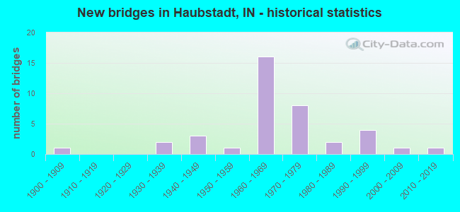
- New bridges - historical statistics
- 11900-1909
- 21930-1939
- 31940-1949
- 11950-1959
- 161960-1969
- 81970-1979
- 21980-1989
- 41990-1999
- 12000-2009
- 12010-2019

- Reconstructed bridges - Historical Statistics
- 41970-1979
- 01980-1989
- 11990-1999
- 22000-2009
- 52010-2019


- Bridge Condition - Deck
- 4.3%Very good
- 34.8%Good
- 43.5%Satisfactory
- 13.0%Fair
- 4.3%Poor

- Bridge Condition - Superstructure
- 56.5%Good
- 39.1%Satisfactory
- 4.3%Poor

- Bridge Condition - Substructure
- 43.5%Good
- 30.4%Satisfactory
- 21.7%Fair
- 4.3%Poor

- Bridge Condition - Channel
- 9.1%Very good
- 18.2%Good
- 40.9%Satisfactory
- 22.7%Fair
- 9.1%Poor

- Bridge Condition - Culverts
- 66.7%Good
- 33.3%Satisfactory
Find on map >> Show street view
Structure Number: 1441, Location: 00.51 S I-64 (Lat: 38.159289, Lng: -87.550650), Route carried "on" structure: US 41, Year Built: 1946, Year Reconstructed: 2014, Status: Open, Structure Length: 1.13m (3.71ft), Average Daily Traffic: 24,053 (year 2004), Truck Traffic: 10%, Average Future Daily Traffic: 33,313 (year 2034), Design Load: HS 20, Features Intersected: DRAINAGE DITCH
Minimum Vertical Clearance: 30+ m (98+ ft), Kilometerpoint: 26.554, Lanes on structure: 6, Base Highway Network: Yes (, Subroute: 1), Owner: State Highway Agency, Approaching Roadway Width: 33.8m (110.9ft), Skew: 20 degrees, Material/Design: Concrete, Design/Construction: Culvert, Number Of Spans In Main Unit: 1, Length of Maximum Span: 10.7m (35.1ft), Curb-To-Curb Width: 33.8m (110.9ft), Out-to-Out Width: 34.7m (113.8ft)
Condition: Channel: Good, Culverts: Good, Operating Rating: 76.4 metric tons, Method Used To Determine Operating Rating: Field evaluation and documented engineering judgment, Inventory Rating: 45.7 metric tons, Method Used To Determine Inventory Rating: Field evaluation and documented engineering judgment, Structural Evaluation: Better than present minimum criteria, Deck Geometry: Superior to present desirable criteria, Waterway Adequacy: Superior to present desirable criteria, Approach Roadway Alignment: Equal to present desirable criteria, Designated Inspection Frequency: Every 24 months, Inspection Date: July 2020
Find on map >> Show street view
Structure Number: 1442, Location: 00.50 S SR68 (Lat: 38.188369, Lng: -87.550039), Route carried "on" structure: US 41, Year Built: 1948, Status: Open, Structure Length: 1.22m (4.00ft), Average Daily Traffic: 23,379 (year 2004), Truck Traffic: 10%, Average Future Daily Traffic: 32,380 (year 2034), Design Load: HS 20, Features Intersected: LUTZ CREEK
Minimum Vertical Clearance: 30+ m (98+ ft), Kilometerpoint: 2.414, Lanes on structure: 4, Base Highway Network: Yes (, Subroute: 1), Owner: State Highway Agency, Approaching Roadway Width: 35.4m (116.1ft), Skew: 20 degrees, Material/Design: Concrete, Design/Construction: Culvert, Number Of Spans In Main Unit: 1, Length of Maximum Span: 12.2m (40.0ft), Curb-To-Curb Width: 14.6m (47.9ft), Out-to-Out Width: 35.4m (116.1ft)
Condition: Channel: Good, Culverts: Good, Operating Rating: 89.8 metric tons, Method Used To Determine Operating Rating: Load Factor (LF), Inventory Rating: 89.8 metric tons, Method Used To Determine Inventory Rating: Load Factor (LF), Structural Evaluation: Better than present minimum criteria, Deck Geometry: High priority of replacement, Waterway Adequacy: Superior to present desirable criteria, Approach Roadway Alignment: Equal to present desirable criteria, Designated Inspection Frequency: Every 24 months, Inspection Date: May 2020
Find on map >> Show street view
Structure Number: 1443, Location: 01.49 N SR 68 (Lat: 38.214581, Lng: -87.559611), Route carried "on" structure: US 41, Year Built: 1950, Status: Open, Structure Length: 1.07m (3.51ft), Average Daily Traffic: 22,693 (year 2004), Truck Traffic: 10%, Average Future Daily Traffic: 31,430 (year 2034), Design Load: HS 20, Features Intersected: THURMAN DITCH
Minimum Vertical Clearance: 30+ m (98+ ft), Kilometerpoint: 5.617, Lanes on structure: 4, Base Highway Network: Yes (, Subroute: 1), Owner: State Highway Agency, Approaching Roadway Width: 33.8m (110.9ft), Skew: 23 degrees, Material/Design: Concrete, Design/Construction: Culvert, Number Of Spans In Main Unit: 1, Length of Maximum Span: 10.7m (35.1ft), Curb-To-Curb Width: 33.8m (110.9ft), Out-to-Out Width: 34.6m (113.5ft)
Condition: Channel: Very good, Culverts: Satisfactory, Operating Rating: 98.0 metric tons, Method Used To Determine Operating Rating: Field evaluation and documented engineering judgment, Inventory Rating: 58.8 metric tons, Method Used To Determine Inventory Rating: Field evaluation and documented engineering judgment, Structural Evaluation: Equal to present minimum criteria, Deck Geometry: Superior to present desirable criteria, Waterway Adequacy: Superior to present desirable criteria, Approach Roadway Alignment: Equal to present desirable criteria, Designated Inspection Frequency: Every 24 months, Inspection Date: May 2020
Find on map >> Show street view
Structure Number: 2438, Location: 00.60 E US 41 (Lat: 38.195931, Lng: -87.538700), Route carried "on" structure: State highway 68, Year Built: 1999, Status: Open, Structure Length: 2.10m (6.89ft), Average Daily Traffic: 1,188 (year 2004), Truck Traffic: 5%, Average Future Daily Traffic: 1,973 (year 2032), Design Load: HS 20, Features Intersected: LUTZ DITCH
Minimum Vertical Clearance: 30+ m (98+ ft), Kilometerpoint: 13.132, Lanes on structure: 2, Owner: State Highway Agency, Approaching Roadway Width: 9.1m (29.9ft), Material/Design: Prestressed concrete, Design/Construction: Stringer/Multi-beam, Number Of Spans In Main Unit: 1, Length of Maximum Span: 20.5m (67.3ft), Curb-To-Curb Width: 9.4m (30.8ft), Out-to-Out Width: 10.3m (33.8ft)
Condition: Deck: Good, Superstructure: Good, Substructure: Good, Channel: Good, Operating Rating: 53.5 metric tons, Method Used To Determine Operating Rating: Load and Resistance Factor Rating (LRFR) rating reported by rating factor(RF) method using HL-93 loadings, Inventory Rating: 29.8 metric tons, Method Used To Determine Inventory Rating: Load and Resistance Factor Rating (LRFR) rating reported by rating factor(RF) method using HL-93 loadings, Structural Evaluation: Better than present minimum criteria, Deck Geometry: Somewhat better than minimum adequacy, Waterway Adequacy: Superior to present desirable criteria, Approach Roadway Alignment: Equal to present desirable criteria, Designated Inspection Frequency: Every 24 months, Inspection Date: July 2021, Deck Structure Type: Concrete Cast-file-Place, Wearing Surface/Protective System: Wearing Surface: Monolithic Concrete, Deck Protection: Epoxy Coated Reinforcing
Find on map >> Show street view
Structure Number: 2439, Location: 01.44 E US 41 (Lat: 38.195739, Lng: -87.522881), Route carried "on" structure: State highway 68, Year Built: 1999, Status: Open, Structure Length: 3.72m (12.20ft), Average Daily Traffic: 1,188 (year 2004), Truck Traffic: 5%, Average Future Daily Traffic: 1,973 (year 2032), Design Load: HS 20, Features Intersected: HURRICANE CREEK
Minimum Vertical Clearance: 30+ m (98+ ft), Kilometerpoint: 14.484, Lanes on structure: 2, Owner: State Highway Agency, Approaching Roadway Width: 9.1m (29.9ft), Skew: 4 degrees, Material/Design: Prestressed concrete continuous, Design/Construction: Stringer/Multi-beam, Number Of Spans In Main Unit: 3, Length of Maximum Span: 12.0m (39.4ft), Curb-To-Curb Width: 10.6m (34.8ft), Out-to-Out Width: 11.5m (37.7ft)
Condition: Deck: Good, Superstructure: Satisfactory, Substructure: Good, Channel: Very good, Operating Rating: 43.5 metric tons, Method Used To Determine Operating Rating: Load Factor (LF), Inventory Rating: 26.0 metric tons, Method Used To Determine Inventory Rating: Load Factor (LF), Structural Evaluation: Equal to present minimum criteria, Deck Geometry: Equal to present minimum criteria, Waterway Adequacy: Superior to present desirable criteria, Approach Roadway Alignment: Equal to present desirable criteria, Designated Inspection Frequency: Every 24 months, Inspection Date: July 2021, Deck Structure Type: Concrete Cast-file-Place, Wearing Surface/Protective System: Wearing Surface: Monolithic Concrete, Deck Protection: Epoxy Coated Reinforcing
Find on map >> Show street view
Structure Number: 3346, Location: 03.04 E SR 65 (Lat: 38.167411, Lng: -87.628939), Route carried "on" structure: County highway , Year Built: 1966, Year Reconstructed: 2015, Status: Open, Structure Length: 6.10m (20.01ft), Average Daily Traffic: 375 (year 2014), Truck Traffic: 10%, Average Future Daily Traffic: 272 (year 2034), Design Load: HS 20, Features Intersected: I-64 EB/WB, Facility Carried by Structure: OWENSVILLE ROAD
Minimum Vertical Clearance: 30+ m (98+ ft), Kilometerpoint: 0.000, Lanes on structure: 2, Lanes under structure: 4, Owner: State Highway Agency, Approaching Roadway Width: 7.3m (24.0ft), Material/Design: Steel continuous, Design/Construction: Stringer/Multi-beam, Number Of Spans In Main Unit: 2, Number Of Approach Spans: 2, Length of Maximum Span: 18.3m (60.0ft), Curb or Sidewalk Widths: Left: 0.8m (2.6ft), Right: 0.8m (2.6ft), Curb-To-Curb Width: 7.3m (24.0ft), Out-to-Out Width: 9.0m (29.5ft)
Condition: Deck: Satisfactory, Superstructure: Good, Substructure: Satisfactory, Operating Rating: 35.3 metric tons, Method Used To Determine Operating Rating: Load and Resistance Factor Rating (LRFR) rating reported by rating factor(RF) method using HL-93 loadings, Inventory Rating: 27.2 metric tons, Method Used To Determine Inventory Rating: Load and Resistance Factor Rating (LRFR) rating reported by rating factor(RF) method using HL-93 loadings, Structural Evaluation: Equal to present minimum criteria, Deck Geometry: Somewhat better than minimum adequacy, Underclear: Meets minimum limits, Approach Roadway Alignment: Equal to present desirable criteria, Designated Inspection Frequency: Every 24 months, Inspection Date: Febuary 2022, Deck Structure Type: Concrete Cast-file-Place, Wearing Surface/Protective System: Wearing Surface: Latex Concrete
Find on map >> Show street view
Structure Number: 3347, Location: 01.19 W US 41 (Lat: 38.167061, Lng: -87.572761), Route carried "on" structure: Alternate County highway , Year Built: 1967, Year Reconstructed: 2004, Status: Open, Structure Length: 6.37m (20.90ft), Average Daily Traffic: 1,306 (year 2004), Truck Traffic: 10%, Average Future Daily Traffic: 2,168 (year 2032), Design Load: HS 20, Features Intersected: I-64 EB/WB, Facility Carried by Structure: EVANSV/PRINC RD
Minimum Vertical Clearance: 30+ m (98+ ft), Kilometerpoint: 0.000, Lanes on structure: 2, Lanes under structure: 4, Owner: State Highway Agency, Approaching Roadway Width: 8.2m (26.9ft), Skew: 1 degrees, Material/Design: Steel continuous, Design/Construction: Stringer/Multi-beam, Number Of Spans In Main Unit: 4, Length of Maximum Span: 19.4m (63.6ft), Curb-To-Curb Width: 8.3m (27.2ft), Out-to-Out Width: 9.2m (30.2ft)
Condition: Deck: Satisfactory, Superstructure: Good, Substructure: Good, Operating Rating: 50.9 metric tons, Method Used To Determine Operating Rating: Load and Resistance Factor Rating (LRFR) rating reported by rating factor(RF) method using HL-93 loadings, Inventory Rating: 39.2 metric tons, Method Used To Determine Inventory Rating: Load and Resistance Factor Rating (LRFR) rating reported by rating factor(RF) method using HL-93 loadings, Structural Evaluation: Better than present minimum criteria, Deck Geometry: Meets minimum limits, Underclear: Meets minimum limits, Approach Roadway Alignment: Equal to present desirable criteria, Designated Inspection Frequency: Every 24 months, Inspection Date: Febuary 2022, Deck Structure Type: Concrete Cast-file-Place, Wearing Surface/Protective System: Wearing Surface: Monolithic Concrete, Deck Protection: Epoxy Coated Reinforcing
Find on map >> Show street view
Structure Number: 3348, Location: 00.77 W US 41 (Lat: 38.166939, Lng: -87.564589), Route carried "on" structure: Interstate 64, Year Built: 1967, Year Reconstructed: 2015, Status: Open, Structure Length: 4.18m (13.71ft), Average Daily Traffic: 5,837 (year 2004), Truck Traffic: 10%, Average Future Daily Traffic: 10,571 (year 2032), Design Load: HS 20, Features Intersected: CSX RR
Minimum Vertical Clearance: 30+ m (98+ ft), Kilometerpoint: 38.978, Lanes on structure: 2, Base Highway Network: Yes (, Subroute: 1), Owner: State Highway Agency, Approaching Roadway Width: 11.9m (39.0ft), Material/Design: Steel continuous, Design/Construction: Stringer/Multi-beam, Number Of Spans In Main Unit: 3, Length of Maximum Span: 15.4m (50.5ft), Curb-To-Curb Width: 12.0m (39.4ft), Out-to-Out Width: 13.0m (42.7ft)
Condition: Deck: Satisfactory, Superstructure: Good, Substructure: Good, Operating Rating: 55.3 metric tons, Method Used To Determine Operating Rating: Load Factor (LF), Inventory Rating: 33.1 metric tons, Method Used To Determine Inventory Rating: Load Factor (LF), Structural Evaluation: Better than present minimum criteria, Deck Geometry: Equal to present minimum criteria, Underclear: Somewhat better than minimum adequacy, Approach Roadway Alignment: Equal to present desirable criteria, Designated Inspection Frequency: Every 24 months, Inspection Date: Febuary 2022, Deck Structure Type: Concrete Cast-file-Place, Wearing Surface/Protective System: Wearing Surface: Other
Find on map >> Show street view
Structure Number: 3349, Location: 00.77 W US 41 (Lat: 38.167131, Lng: -87.564589), Route carried "on" structure: Interstate 64, Year Built: 1967, Year Reconstructed: 2015, Status: Open, Structure Length: 4.18m (13.71ft), Average Daily Traffic: 5,837 (year 2004), Truck Traffic: 10%, Average Future Daily Traffic: 10,571 (year 2032), Design Load: HS 20, Features Intersected: CSX RR
Minimum Vertical Clearance: 30+ m (98+ ft), Kilometerpoint: 38.978, Lanes on structure: 2, Base Highway Network: Yes (, Subroute: 1), Owner: State Highway Agency, Approaching Roadway Width: 11.9m (39.0ft), Material/Design: Steel continuous, Design/Construction: Stringer/Multi-beam, Number Of Spans In Main Unit: 3, Length of Maximum Span: 15.4m (50.5ft), Curb-To-Curb Width: 12.0m (39.4ft), Out-to-Out Width: 13.0m (42.7ft)
Condition: Deck: Fair, Superstructure: Good, Substructure: Good, Operating Rating: 39.5 metric tons, Method Used To Determine Operating Rating: Load and Resistance Factor Rating (LRFR) rating reported by rating factor(RF) method using HL-93 loadings, Inventory Rating: 30.5 metric tons, Method Used To Determine Inventory Rating: Load and Resistance Factor Rating (LRFR) rating reported by rating factor(RF) method using HL-93 loadings, Structural Evaluation: Better than present minimum criteria, Deck Geometry: Equal to present minimum criteria, Underclear: Somewhat better than minimum adequacy, Approach Roadway Alignment: Equal to present desirable criteria, Designated Inspection Frequency: Every 24 months, Inspection Date: Febuary 2022, Deck Structure Type: Concrete Cast-file-Place, Wearing Surface/Protective System: Wearing Surface: Other
Find on map >> Show street view
Structure Number: 335, Location: 04.35 W SR 57 (Lat: 38.166919, Lng: -87.550519), Route carried "on" structure: Interstate 64, Year Built: 1968, Year Reconstructed: 2018, Status: Open, Structure Length: 6.34m (20.80ft), Average Daily Traffic: 7,480 (year 2018), Truck Traffic: 35%, Average Future Daily Traffic: 8,745 (year 2038), Design Load: HS 20+Mod, Features Intersected: US 41 NB/SB
Minimum Vertical Clearance: 30+ m (98+ ft), Kilometerpoint: 40.218, Lanes on structure: 3, Lanes under structure: 6, Base Highway Network: Yes (, Subroute: 1), Owner: State Highway Agency, Approaching Roadway Width: 12.2m (40.0ft), Material/Design: Steel continuous, Design/Construction: Stringer/Multi-beam, Number Of Spans In Main Unit: 4, Length of Maximum Span: 20.5m (67.3ft), Curb-To-Curb Width: 13.9m (45.6ft), Out-to-Out Width: 14.8m (48.6ft)
Condition: Deck: Very good, Superstructure: Good, Substructure: Good, Operating Rating: 59.0 metric tons, Method Used To Determine Operating Rating: Load and Resistance Factor Rating (LRFR) rating reported by rating factor(RF) method using HL-93 loadings, Inventory Rating: 45.7 metric tons, Method Used To Determine Inventory Rating: Load and Resistance Factor Rating (LRFR) rating reported by rating factor(RF) method using HL-93 loadings, Structural Evaluation: Better than present minimum criteria, Deck Geometry: Meets minimum limits, Underclear: Meets minimum limits, Approach Roadway Alignment: Equal to present desirable criteria, Designated Inspection Frequency: Every 24 months, Inspection Date: Febuary 2022, Deck Structure Type: Concrete Cast-file-Place, Wearing Surface/Protective System: Wearing Surface: Monolithic Concrete, Deck Protection: Epoxy Coated Reinforcing
Find on map >> Show street view
Structure Number: 3351, Location: 04.35 W SR 57 (Lat: 38.167161, Lng: -87.550531), Route carried "on" structure: Interstate 64, Year Built: 1968, Year Reconstructed: 2018, Status: Open, Structure Length: 6.34m (20.80ft), Average Daily Traffic: 7,480 (year 2018), Truck Traffic: 35%, Average Future Daily Traffic: 8,745 (year 2038), Design Load: HS 20+Mod, Features Intersected: US 41 NB/SB
Minimum Vertical Clearance: 30+ m (98+ ft), Kilometerpoint: 40.218, Lanes on structure: 3, Lanes under structure: 6, Base Highway Network: Yes (, Subroute: 1), Owner: State Highway Agency, Approaching Roadway Width: 12.2m (40.0ft), Material/Design: Steel continuous, Design/Construction: Stringer/Multi-beam, Number Of Spans In Main Unit: 4, Length of Maximum Span: 20.3m (66.6ft), Curb-To-Curb Width: 13.9m (45.6ft), Out-to-Out Width: 14.8m (48.6ft)
Condition: Deck: Good, Superstructure: Good, Substructure: Good, Operating Rating: 59.0 metric tons, Method Used To Determine Operating Rating: Load and Resistance Factor Rating (LRFR) rating reported by rating factor(RF) method using HL-93 loadings, Inventory Rating: 45.7 metric tons, Method Used To Determine Inventory Rating: Load and Resistance Factor Rating (LRFR) rating reported by rating factor(RF) method using HL-93 loadings, Structural Evaluation: Better than present minimum criteria, Deck Geometry: Meets minimum limits, Underclear: Meets minimum limits, Approach Roadway Alignment: Equal to present desirable criteria, Designated Inspection Frequency: Every 24 months, Inspection Date: Febuary 2022, Deck Structure Type: Concrete Cast-file-Place, Wearing Surface/Protective System: Wearing Surface: Monolithic Concrete
Find on map >> Show street view
Structure Number: 3352, Location: 01.02 E US 41 (Lat: 38.166789, Lng: -87.530819), Route carried "on" structure: Alternate County highway , Year Built: 1971, Year Reconstructed: 2000, Status: Posted for load, Structure Length: 7.44m (24.41ft), Average Daily Traffic: 338 (year 2004), Truck Traffic: 10%, Average Future Daily Traffic: 561 (year 2032), Design Load: HS 20, Features Intersected: I-64 EB/WB, Facility Carried by Structure: CR 200E (OLD SR)
Minimum Vertical Clearance: 30+ m (98+ ft), Kilometerpoint: 0.000, Lanes on structure: 2, Lanes under structure: 4, Owner: State Highway Agency, Approaching Roadway Width: 7.9m (25.9ft), Skew: 3 degrees, Material/Design: Steel continuous, Design/Construction: Stringer/Multi-beam, Number Of Spans In Main Unit: 2, Length of Maximum Span: 36.8m (120.7ft), Curb-To-Curb Width: 9.8m (32.2ft), Out-to-Out Width: 10.7m (35.1ft)
Condition: Deck: Satisfactory, Superstructure: Good, Substructure: Good, Operating Rating: 21.6 metric tons, Method Used To Determine Operating Rating: Load and Resistance Factor (LRFR), Inventory Rating: 19.7 metric tons, Method Used To Determine Inventory Rating: Load and Resistance Factor (LRFR), Structural Evaluation: Somewhat better than minimum adequacy, Deck Geometry: Better than present minimum criteria, Underclear: Somewhat better than minimum adequacy, Approach Roadway Alignment: Equal to present desirable criteria, Bridge Posting: Required (Relationship of Operating Rating to Maximum Legal Load: 30.0 - 39.9% below), Designated Inspection Frequency: Every 24 months, Inspection Date: March 2022, Deck Structure Type: Concrete Cast-file-Place, Wearing Surface/Protective System: Wearing Surface: Latex Concrete
Find on map >> Show street view
Structure Number: 2600156, Location: 00.70 S OF CR 850 S (Lat: 38.220489, Lng: -87.610367), Route carried "on" structure: County highway , Year Built: 1984, Status: Open, Structure Length: 0.98m (3.22ft), Average Daily Traffic: 100 (year 2012), Truck Traffic: 4%, Average Future Daily Traffic: 150 (year 2032), Features Intersected: BRANCH OF SANDY CREEK, Facility Carried by Structure: CR 225 W
Minimum Vertical Clearance: 30+ m (98+ ft), Kilometerpoint: 0.000, Lanes on structure: 2, Owner: County Highway Agency, Approaching Roadway Width: 5.2m (17.1ft), Skew: 1 degrees, Material/Design: Steel, Design/Construction: Stringer/Multi-beam, Number Of Spans In Main Unit: 1, Length of Maximum Span: 8.5m (27.9ft), Curb-To-Curb Width: 7.2m (23.6ft), Out-to-Out Width: 7.3m (24.0ft)
Condition: Deck: Good, Superstructure: Satisfactory, Substructure: Good, Channel: Satisfactory, Operating Rating: 97.5 metric tons, Method Used To Determine Operating Rating: Load Factor (LF), Inventory Rating: 58.3 metric tons, Method Used To Determine Inventory Rating: Load Factor (LF), Structural Evaluation: Equal to present minimum criteria, Deck Geometry: Somewhat better than minimum adequacy, Waterway Adequacy: Equal to present minimum criteria, Approach Roadway Alignment: Equal to present minimum criteria, Designated Inspection Frequency: Every 24 months, Inspection Date: April 2020, Deck Structure Type: Concrete Cast-file-Place, Wearing Surface/Protective System: Wearing Surface: Monolithic Concrete
Find on map >> Show street view
Structure Number: 2600172, Location: 00.90 W OF SR 68 (Lat: 38.201361, Lng: -87.640206), Route carried "on" structure: County highway , Year Built: 1971, Status: Open, Structure Length: 1.04m (3.41ft), Average Daily Traffic: 100 (year 2012), Truck Traffic: 3%, Average Future Daily Traffic: 150 (year 2032), Features Intersected: JORDAN CREEK, Facility Carried by Structure: CR 1050 S
Minimum Vertical Clearance: 30+ m (98+ ft), Kilometerpoint: 0.000, Lanes on structure: 2, Owner: County Highway Agency, Approaching Roadway Width: 5.2m (17.1ft), Material/Design: Steel, Design/Construction: Stringer/Multi-beam, Number Of Spans In Main Unit: 1, Length of Maximum Span: 9.9m (32.5ft), Curb-To-Curb Width: 7.2m (23.6ft), Out-to-Out Width: 7.3m (24.0ft)
Condition: Deck: Satisfactory, Superstructure: Satisfactory, Substructure: Fair, Channel: Fair, Operating Rating: 48.2 metric tons, Method Used To Determine Operating Rating: Load Factor (LF), Inventory Rating: 28.9 metric tons, Method Used To Determine Inventory Rating: Load Factor (LF), Structural Evaluation: Somewhat better than minimum adequacy, Deck Geometry: Somewhat better than minimum adequacy, Waterway Adequacy: Somewhat better than minimum adequacy, Approach Roadway Alignment: Equal to present minimum criteria, Length Of Structure Improvement: 1.71m (5.61ft), Designated Inspection Frequency: Every 24 months, Inspection Date: April 2020, Bridge Improvement Cost: $231,000, Roadway Improvement Cost: $184,000, Total Project Cost: $524,000 ( Estimate for 2020), Deck Structure Type: Concrete Cast-file-Place, Wearing Surface/Protective System: Wearing Surface: Bituminous
Find on map >> Show street view
Structure Number: 2600182, Location: 00.50 E OF US 41 (Lat: 38.219631, Lng: -87.554750), Route carried "on" structure: County highway , Year Built: 1969, Status: Open, Structure Length: 1.36m (4.46ft), Average Daily Traffic: 125 (year 2012), Truck Traffic: 3%, Average Future Daily Traffic: 150 (year 2032), Features Intersected: HURRICANE CREEK, Facility Carried by Structure: CR 925 S
Minimum Vertical Clearance: 30+ m (98+ ft), Kilometerpoint: 0.000, Lanes on structure: 2, Owner: County Highway Agency, Approaching Roadway Width: 4.9m (16.1ft), Material/Design: Steel, Design/Construction: Stringer/Multi-beam, Number Of Spans In Main Unit: 1, Length of Maximum Span: 12.7m (41.7ft), Curb-To-Curb Width: 6.6m (21.7ft), Out-to-Out Width: 6.7m (22.0ft)
Condition: Deck: Satisfactory, Superstructure: Satisfactory, Substructure: Satisfactory, Channel: Poor, Operating Rating: 44.1 metric tons, Method Used To Determine Operating Rating: Load Factor (LF), Inventory Rating: 26.4 metric tons, Method Used To Determine Inventory Rating: Load Factor (LF), Structural Evaluation: Equal to present minimum criteria, Deck Geometry: Meets minimum limits, Waterway Adequacy: Equal to present minimum criteria, Approach Roadway Alignment: Equal to present desirable criteria, Designated Inspection Frequency: Every 24 months, Inspection Date: March 2020, Deck Structure Type: Concrete Cast-file-Place, Wearing Surface/Protective System: Wearing Surface: Bituminous
Find on map >> Show street view
Structure Number: 2600183, Location: 00.60 N OF CR 1025 S (Lat: 38.213361, Lng: -87.549094), Route carried "on" structure: County highway , Year Built: 1935, Year Reconstructed: 1981, Status: Posted for load, Structure Length: 1.55m (5.09ft), Average Daily Traffic: 120 (year 2012), Truck Traffic: 5%, Average Future Daily Traffic: 145 (year 2032), Features Intersected: HURRICANE CREEK, Facility Carried by Structure: CR 990 S
Minimum Vertical Clearance: 30+ m (98+ ft), Kilometerpoint: 0.000, Lanes on structure: 2, Owner: County Highway Agency, Approaching Roadway Width: 4.9m (16.1ft), Skew: 1 degrees, Material/Design: Steel, Design/Construction: Stringer/Multi-beam, Number Of Spans In Main Unit: 1, Length of Maximum Span: 14.4m (47.2ft), Curb-To-Curb Width: 7.3m (24.0ft), Out-to-Out Width: 7.5m (24.6ft)
Condition: Deck: Satisfactory, Superstructure: Satisfactory, Substructure: Satisfactory, Channel: Satisfactory, Operating Rating: 32.3 metric tons, Method Used To Determine Operating Rating: Load Factor (LF), Inventory Rating: 19.3 metric tons, Method Used To Determine Inventory Rating: Load Factor (LF), Structural Evaluation: Somewhat better than minimum adequacy, Deck Geometry: Somewhat better than minimum adequacy, Waterway Adequacy: Better than present minimum criteria, Approach Roadway Alignment: Equal to present minimum criteria, Bridge Posting: Required (Relationship of Operating Rating to Maximum Legal Load: 0.1 - 9.9% below), Designated Inspection Frequency: Every 24 months, Inspection Date: April 2020, Deck Structure Type: Concrete Cast-file-Place, Wearing Surface/Protective System: Wearing Surface: Bituminous
Find on map >> Show street view
Structure Number: 2600188, Location: 00.90 E OF US 41 (Lat: 38.205019, Lng: -87.536172), Route carried "on" structure: County highway , Year Built: 1987, Status: Open, Structure Length: 2.51m (8.23ft), Average Daily Traffic: 130 (year 2012), Truck Traffic: 3%, Average Future Daily Traffic: 165 (year 2032), Features Intersected: BRANCH OF HURRICANE CR, Facility Carried by Structure: CR 1025 S
Minimum Vertical Clearance: 30+ m (98+ ft), Kilometerpoint: 0.000, Lanes on structure: 2, Owner: County Highway Agency, Approaching Roadway Width: 4.9m (16.1ft), Skew: 4 degrees, Material/Design: Steel, Design/Construction: Stringer/Multi-beam, Number Of Spans In Main Unit: 2, Length of Maximum Span: 14.6m (47.9ft), Curb-To-Curb Width: 6.2m (20.3ft), Out-to-Out Width: 6.2m (20.3ft)
Condition: Deck: Satisfactory, Superstructure: Good, Substructure: Satisfactory, Channel: Satisfactory, Operating Rating: 50.0 metric tons, Method Used To Determine Operating Rating: Load Factor (LF), Inventory Rating: 29.9 metric tons, Method Used To Determine Inventory Rating: Load Factor (LF), Structural Evaluation: Equal to present minimum criteria, Deck Geometry: Meets minimum limits, Waterway Adequacy: Equal to present minimum criteria, Approach Roadway Alignment: Equal to present minimum criteria, Designated Inspection Frequency: Every 24 months, Inspection Date: April 2020, Deck Structure Type: Concrete Cast-file-Place, Wearing Surface/Protective System: Wearing Surface: Bituminous
Find on map >> Show street view
Structure Number: 2600233, Location: 00.80 N OF CR 1200 S (Lat: 38.193581, Lng: -87.577628), Route carried "on" structure: County highway , Year Built: 1993, Status: Open, Structure Length: 1.20m (3.94ft), Average Daily Traffic: 700 (year 2012), Truck Traffic: 6%, Average Future Daily Traffic: 900 (year 2032), Design Load: HS 20, Features Intersected: BRANCH OF POND FLAT DIT, Facility Carried by Structure: CR 50 E
Minimum Vertical Clearance: 30+ m (98+ ft), Kilometerpoint: 0.000, Lanes on structure: 2, Owner: County Highway Agency, Approaching Roadway Width: 5.5m (18.0ft), Material/Design: Aluminum, Iron, Design/Construction: Culvert, Number Of Spans In Main Unit: 1, Length of Maximum Span: 7.3m (24.0ft), Curb-To-Curb Width: 5.5m (18.0ft), Out-to-Out Width: 5.5m (18.0ft)
Condition: Channel: Satisfactory, Culverts: Satisfactory, Operating Rating: 70.3 metric tons, Method Used To Determine Operating Rating: Load and Resistance Factor (LRFR), Inventory Rating: 45.7 metric tons, Method Used To Determine Inventory Rating: Load and Resistance Factor (LRFR), Structural Evaluation: Equal to present minimum criteria, Deck Geometry: High priority of replacement, Waterway Adequacy: Equal to present minimum criteria, Approach Roadway Alignment: Equal to present desirable criteria, Designated Inspection Frequency: Every 24 months, Inspection Date: April 2020
Find on map >> Show street view
Structure Number: 2600234, Location: 00.30 S OF CR 1200 S (Lat: 38.178831, Lng: -87.631142), Route carried "on" structure: County highway , Year Built: 1976, Status: Posted for load, Structure Length: 0.96m (3.15ft), Average Daily Traffic: 225 (year 2012), Truck Traffic: 4%, Average Future Daily Traffic: 285 (year 2032), Features Intersected: BRANCH OF JORDAN CREEK, Facility Carried by Structure: CR 325 W
Minimum Vertical Clearance: 30+ m (98+ ft), Kilometerpoint: 0.000, Lanes on structure: 2, Owner: County Highway Agency, Approaching Roadway Width: 5.2m (17.1ft), Material/Design: Steel, Design/Construction: Stringer/Multi-beam, Number Of Spans In Main Unit: 1, Length of Maximum Span: 8.4m (27.6ft), Curb-To-Curb Width: 7.2m (23.6ft), Out-to-Out Width: 7.3m (24.0ft)
Condition: Deck: Good, Superstructure: Satisfactory, Substructure: Fair, Channel: Satisfactory, Operating Rating: 23.1 metric tons, Method Used To Determine Operating Rating: Load Factor (LF), Inventory Rating: 13.8 metric tons, Method Used To Determine Inventory Rating: Load Factor (LF), Structural Evaluation: Meets minimum limits, Deck Geometry: Meets minimum limits, Waterway Adequacy: Somewhat better than minimum adequacy, Approach Roadway Alignment: Equal to present desirable criteria, Bridge Posting: Required (Relationship of Operating Rating to Maximum Legal Load: 20.0 - 29.9% below), Designated Inspection Frequency: Every 24 months, Inspection Date: March 2020, Deck Structure Type: Concrete Cast-file-Place, Wearing Surface/Protective System: Wearing Surface: Bituminous
Find on map >> Show street view
Structure Number: 2600235, Location: 00.20 S OF CR 1200 S (Lat: 38.182450, Lng: -87.631142), Route carried "on" structure: County highway , Year Built: 1976, Status: Open, Structure Length: 0.76m (2.49ft), Average Daily Traffic: 225 (year 2012), Truck Traffic: 4%, Average Future Daily Traffic: 290 (year 2032), Features Intersected: BRANCH OF JORDAN CREEK, Facility Carried by Structure: CR 325 W
Minimum Vertical Clearance: 30+ m (98+ ft), Kilometerpoint: 0.000, Lanes on structure: 2, Owner: County Highway Agency, Approaching Roadway Width: 5.5m (18.0ft), Skew: 3 degrees, Material/Design: Steel, Design/Construction: Stringer/Multi-beam, Number Of Spans In Main Unit: 1, Length of Maximum Span: 7.0m (23.0ft), Curb-To-Curb Width: 7.2m (23.6ft), Out-to-Out Width: 7.3m (24.0ft)
Condition: Deck: Fair, Superstructure: Satisfactory, Substructure: Fair, Channel: Poor, Operating Rating: 63.1 metric tons, Method Used To Determine Operating Rating: Load Factor (LF), Inventory Rating: 37.8 metric tons, Method Used To Determine Inventory Rating: Load Factor (LF), Structural Evaluation: Somewhat better than minimum adequacy, Deck Geometry: Meets minimum limits, Waterway Adequacy: Meets minimum limits, Approach Roadway Alignment: High priority of corrective action, Designated Inspection Frequency: Every 24 months, Inspection Date: April 2020, Deck Structure Type: Concrete Cast-file-Place, Wearing Surface/Protective System: Wearing Surface: Bituminous
Find on map >> Show street view
Structure Number: 2600236, Location: 00.40 E OF CR 325 W (Lat: 38.182389, Lng: -87.622681), Route carried "on" structure: County highway 8, Year Built: 1997, Status: Open, Structure Length: 1.52m (4.99ft), Average Daily Traffic: 125 (year 2012), Truck Traffic: 3%, Average Future Daily Traffic: 150 (year 2032), Features Intersected: BRANCH OF MEUSES CREEK, Facility Carried by Structure: CR 1200 S
Minimum Vertical Clearance: 30+ m (98+ ft), Kilometerpoint: 0.000, Lanes on structure: 2, Owner: County Highway Agency, Approaching Roadway Width: 5.8m (19.0ft), Material/Design: Aluminum, Iron, Design/Construction: Culvert, Number Of Spans In Main Unit: 1, Length of Maximum Span: 7.9m (25.9ft), Curb-To-Curb Width: 5.8m (19.0ft), Out-to-Out Width: 5.8m (19.0ft)
Condition: Channel: Satisfactory, Culverts: Good, Operating Rating: 61.2 metric tons, Method Used To Determine Operating Rating: Load and Resistance Factor (LRFR), Inventory Rating: 39.7 metric tons, Method Used To Determine Inventory Rating: Load and Resistance Factor (LRFR), Structural Evaluation: Better than present minimum criteria, Deck Geometry: High priority of corrective action, Waterway Adequacy: Equal to present minimum criteria, Approach Roadway Alignment: Equal to present desirable criteria, Designated Inspection Frequency: Every 24 months, Inspection Date: April 2020
Find on map >> Show street view
Structure Number: 2600254, Location: 00.10 S OF SR 68 (Lat: 38.195331, Lng: -87.522058), Route carried "on" structure: County highway , Year Built: 1930, Year Reconstructed: 1982, Status: Open, Structure Length: 1.27m (4.17ft), Average Daily Traffic: 115 (year 2012), Truck Traffic: 3%, Average Future Daily Traffic: 140 (year 2032), Features Intersected: HURRICANE CREEK, Facility Carried by Structure: CR 250 E
Minimum Vertical Clearance: 30+ m (98+ ft), Kilometerpoint: 0.000, Lanes on structure: 2, Owner: County Highway Agency, Approaching Roadway Width: 4.6m (15.1ft), Material/Design: Steel, Design/Construction: Stringer/Multi-beam, Number Of Spans In Main Unit: 1, Length of Maximum Span: 11.6m (38.1ft), Curb-To-Curb Width: 5.3m (17.4ft), Out-to-Out Width: 5.3m (17.4ft)
Condition: Deck: Fair, Superstructure: Good, Substructure: Fair, Channel: Fair, Operating Rating: 70.6 metric tons, Method Used To Determine Operating Rating: Load Factor (LF), Inventory Rating: 42.2 metric tons, Method Used To Determine Inventory Rating: Load Factor (LF), Structural Evaluation: Somewhat better than minimum adequacy, Deck Geometry: High priority of replacement, Waterway Adequacy: Somewhat better than minimum adequacy, Approach Roadway Alignment: Equal to present minimum criteria, Length Of Structure Improvement: 1.28m (4.20ft), Designated Inspection Frequency: Every 24 months, Inspection Date: April 2020, Bridge Improvement Cost: $95,000, Roadway Improvement Cost: $184,000, Total Project Cost: $338,000 ( Estimate for 2020), Deck Structure Type: Concrete Cast-file-Place, Wearing Surface/Protective System: Wearing Surface: Bituminous
Find on map >> Show street view
Structure Number: 2600255, Location: 00.30 S OF SR 68 (Lat: 38.192250, Lng: -87.559167), Route carried "on" structure: County highway 105, Year Built: 1969, Status: Posted for load, Structure Length: 1.01m (3.31ft), Average Daily Traffic: 150 (year 2012), Truck Traffic: 3%, Average Future Daily Traffic: 190 (year 2032), Features Intersected: HURRICANE CREEK, Facility Carried by Structure: CR 50 E
Minimum Vertical Clearance: 30+ m (98+ ft), Kilometerpoint: 0.000, Lanes on structure: 2, Owner: County Highway Agency, Approaching Roadway Width: 5.8m (19.0ft), Skew: 1 degrees, Material/Design: Steel, Design/Construction: Stringer/Multi-beam, Number Of Spans In Main Unit: 1, Length of Maximum Span: 9.1m (29.9ft), Curb-To-Curb Width: 6.0m (19.7ft), Out-to-Out Width: 6.1m (20.0ft)
Condition: Deck: Satisfactory, Superstructure: Satisfactory, Substructure: Satisfactory, Channel: Satisfactory, Operating Rating: 33.5 metric tons, Method Used To Determine Operating Rating: Load Factor (LF), Inventory Rating: 20.0 metric tons, Method Used To Determine Inventory Rating: Load Factor (LF), Structural Evaluation: Somewhat better than minimum adequacy, Deck Geometry: High priority of corrective action, Waterway Adequacy: Meets minimum limits, Approach Roadway Alignment: Equal to present desirable criteria, Designated Inspection Frequency: Every 24 months, Inspection Date: March 2020, Deck Structure Type: Concrete Cast-file-Place, Wearing Surface/Protective System: Wearing Surface: Bituminous
Find on map >> Show street view
Structure Number: 2600257, Location: 00.30 S OF SR 68 (Lat: 38.192250, Lng: -87.539139), Route carried "on" structure: County highway , Year Built: 1978, Status: Posted for load, Structure Length: 1.26m (4.13ft), Average Daily Traffic: 185 (year 2012), Truck Traffic: 4%, Average Future Daily Traffic: 235 (year 2032), Features Intersected: BRANCH OF HURRICANE CR, Facility Carried by Structure: OLD STATE RD
Minimum Vertical Clearance: 30+ m (98+ ft), Kilometerpoint: 0.000, Lanes on structure: 2, Owner: County Highway Agency, Approaching Roadway Width: 5.2m (17.1ft), Skew: 3 degrees, Material/Design: Steel, Design/Construction: Stringer/Multi-beam, Number Of Spans In Main Unit: 1, Length of Maximum Span: 11.5m (37.7ft), Curb-To-Curb Width: 6.5m (21.3ft), Out-to-Out Width: 6.6m (21.7ft)
Condition: Deck: Good, Superstructure: Satisfactory, Substructure: Satisfactory, Channel: Fair, Operating Rating: 24.4 metric tons, Method Used To Determine Operating Rating: Load Factor (LF), Inventory Rating: 14.6 metric tons, Method Used To Determine Inventory Rating: Load Factor (LF), Structural Evaluation: Meets minimum limits, Deck Geometry: Meets minimum limits, Waterway Adequacy: Somewhat better than minimum adequacy, Approach Roadway Alignment: Equal to present desirable criteria, Bridge Posting: Required (Relationship of Operating Rating to Maximum Legal Load: 20.0 - 29.9% below), Length Of Structure Improvement: 1.95m (6.40ft), Designated Inspection Frequency: Every 24 months, Inspection Date: April 2020, Bridge Improvement Cost: $298,000, Roadway Improvement Cost: $184,000, Total Project Cost: $609,000 ( Estimate for 2020), Deck Structure Type: Concrete Cast-file-Place, Wearing Surface/Protective System: Wearing Surface: Bituminous
Find on map >> Show street view
Structure Number: 2600259, Location: 00.60 W OF CR 350 E (Lat: 38.180631, Lng: -87.514061), Route carried "on" structure: County highway , Year Built: 1901, Year Reconstructed: 1984, Status: Open, Structure Length: 1.01m (3.31ft), Average Daily Traffic: 105 (year 2012), Truck Traffic: 5%, Average Future Daily Traffic: 140 (year 2032), Features Intersected: BRANCH OF HURRICANE CR, Facility Carried by Structure: KIEL RD
Minimum Vertical Clearance: 30+ m (98+ ft), Kilometerpoint: 0.000, Lanes on structure: 1, Owner: County Highway Agency, Approaching Roadway Width: 4.9m (16.1ft), Material/Design: Steel, Design/Construction: Stringer/Multi-beam, Number Of Spans In Main Unit: 1, Length of Maximum Span: 9.2m (30.2ft), Curb-To-Curb Width: 4.7m (15.4ft), Out-to-Out Width: 4.7m (15.4ft)
Condition: Deck: Satisfactory, Superstructure: Good, Substructure: Satisfactory, Channel: Fair, Operating Rating: 59.6 metric tons, Method Used To Determine Operating Rating: Load Factor (LF), Inventory Rating: 35.7 metric tons, Method Used To Determine Inventory Rating: Load Factor (LF), Structural Evaluation: Equal to present minimum criteria, Deck Geometry: High priority of replacement, Waterway Adequacy: High priority of corrective action, Approach Roadway Alignment: Equal to present minimum criteria, Designated Inspection Frequency: Every 24 months, Inspection Date: April 2020, Deck Structure Type: Concrete Cast-file-Place, Wearing Surface/Protective System: Wearing Surface: Monolithic Concrete
Find on map >> Show street view
Structure Number: 2600328, Location: 00.10 E OF CR 325 W (Lat: 38.183431, Lng: -87.629711), Route carried "on" structure: County highway 8, Year Built: 2003, Status: Open, Structure Length: 1.08m (3.54ft), Average Daily Traffic: 125 (year 2012), Truck Traffic: 3%, Average Future Daily Traffic: 150 (year 2032), Features Intersected: BRANCH OF MEUSES CREEK, Facility Carried by Structure: CR 1200 S
Minimum Vertical Clearance: 30+ m (98+ ft), Kilometerpoint: 0.000, Lanes on structure: 1, Owner: County Highway Agency, Approaching Roadway Width: 4.6m (15.1ft), Material/Design: Aluminum, Iron, Design/Construction: Culvert, Number Of Spans In Main Unit: 1, Length of Maximum Span: 6.4m (21.0ft), Curb-To-Curb Width: 4.6m (15.1ft), Out-to-Out Width: 4.6m (15.1ft)
Condition: Channel: Satisfactory, Culverts: Good, Operating Rating: 64.1 metric tons, Method Used To Determine Operating Rating: Load and Resistance Factor (LRFR), Inventory Rating: 41.7 metric tons, Method Used To Determine Inventory Rating: Load and Resistance Factor (LRFR), Structural Evaluation: Better than present minimum criteria, Deck Geometry: High priority of replacement, Waterway Adequacy: Better than present minimum criteria, Approach Roadway Alignment: Equal to present desirable criteria, Designated Inspection Frequency: Every 24 months, Inspection Date: April 2020
Find on map >> Show street view
Structure Number: 2600348, Location: 00.80 E OF US 41 (Lat: 38.205031, Lng: -87.537642), Route carried "on" structure: County highway , Year Built: 2013, Status: Open, Structure Length: 1.89m (6.20ft), Average Daily Traffic: 135 (year 2012), Truck Traffic: 3%, Average Future Daily Traffic: 170 (year 2032), Features Intersected: HURRICANE CREEK, Facility Carried by Structure: CR 1025 S
Minimum Vertical Clearance: 30+ m (98+ ft), Kilometerpoint: 0.000, Lanes on structure: 2, Owner: County Highway Agency, Approaching Roadway Width: 4.6m (15.1ft), Material/Design: Steel, Design/Construction: Stringer/Multi-beam, Number Of Spans In Main Unit: 1, Length of Maximum Span: 18.7m (61.4ft), Curb-To-Curb Width: 7.3m (24.0ft), Out-to-Out Width: 7.3m (24.0ft)
Condition: Deck: Good, Superstructure: Good, Substructure: Good, Channel: Good, Operating Rating: 87.5 metric tons, Method Used To Determine Operating Rating: Load Factor (LF), Inventory Rating: 52.4 metric tons, Method Used To Determine Inventory Rating: Load Factor (LF), Structural Evaluation: Better than present minimum criteria, Deck Geometry: Somewhat better than minimum adequacy, Waterway Adequacy: Equal to present minimum criteria, Approach Roadway Alignment: Equal to present minimum criteria, Designated Inspection Frequency: Every 24 months, Inspection Date: April 2020, Deck Structure Type: Concrete Cast-file-Place, Wearing Surface/Protective System: Wearing Surface: Monolithic Concrete
Find on map >> Show street view
Structure Number: 8200042, Location: 00.10 S OF ADLER RD (Lat: 38.157919, Lng: -87.570311), Route carried "on" structure: County highway , Year Built: 1979, Status: Open, Structure Length: 2.07m (6.79ft), Average Daily Traffic: 1,231 (year 2020), Truck Traffic: 3%, Average Future Daily Traffic: 1,639 (year 2040), Features Intersected: BRANCH OF POND FLAT DIT, Facility Carried by Structure: OLD PRINCETON RD
Minimum Vertical Clearance: 30+ m (98+ ft), Kilometerpoint: 0.000, Lanes on structure: 2, Owner: County Highway Agency, Approaching Roadway Width: 6.4m (21.0ft), Skew: 3 degrees, Material/Design: Prestressed concrete, Design/Construction: Box Beam or Girders - Multiple, Number Of Spans In Main Unit: 1, Length of Maximum Span: 20.4m (66.9ft), Curb-To-Curb Width: 9.7m (31.8ft), Out-to-Out Width: 9.8m (32.2ft)
Condition: Deck: Good, Superstructure: Good, Substructure: Fair, Channel: Satisfactory, Operating Rating: 42.1 metric tons, Method Used To Determine Operating Rating: Field evaluation and documented engineering judgment, Inventory Rating: 25.1 metric tons, Method Used To Determine Inventory Rating: Field evaluation and documented engineering judgment, Structural Evaluation: Somewhat better than minimum adequacy, Deck Geometry: Somewhat better than minimum adequacy, Waterway Adequacy: Equal to present minimum criteria, Approach Roadway Alignment: Equal to present desirable criteria, Designated Inspection Frequency: Every 24 months, Inspection Date: October 2020, Deck Structure Type: Concrete Precast Panels, Wearing Surface/Protective System: Wearing Surface: Bituminous
Find on map >> Show street view
Structure Number: 8200043, Location: 00.10 W OF OLD PRINC. RD (Lat: 38.159561, Lng: -87.573611), Route carried "on" structure: County highway , Year Built: 1945, Year Reconstructed: 1979, Status: Open, Structure Length: 0.91m (2.99ft), Average Daily Traffic: 111 (year 2020), Truck Traffic: 1%, Average Future Daily Traffic: 148 (year 2040), Features Intersected: BRANCH OF POND FLAT DIT, Facility Carried by Structure: ADLER RD
Minimum Vertical Clearance: 30+ m (98+ ft), Kilometerpoint: 0.000, Lanes on structure: 2, Owner: County Highway Agency, Approaching Roadway Width: 5.8m (19.0ft), Material/Design: Steel, Design/Construction: Stringer/Multi-beam, Number Of Spans In Main Unit: 1, Length of Maximum Span: 8.8m (28.9ft), Curb-To-Curb Width: 7.1m (23.3ft), Out-to-Out Width: 7.3m (24.0ft)
Condition: Deck: Poor, Superstructure: Poor, Substructure: Poor, Channel: Fair, Operating Rating: 42.1 metric tons, Method Used To Determine Operating Rating: Load Factor (LF), Inventory Rating: 25.5 metric tons, Method Used To Determine Inventory Rating: Load Factor (LF), Structural Evaluation: Meets minimum limits, Deck Geometry: Meets minimum limits, Waterway Adequacy: Meets minimum limits, Approach Roadway Alignment: Equal to present desirable criteria, Length Of Structure Improvement: 1.55m (5.09ft), Designated Inspection Frequency: Every 12 months, Inspection Date: October 2021, Bridge Improvement Cost: $275,000, Roadway Improvement Cost: $200,000, Total Project Cost: $475,000 ( Estimate for 2021), Deck Structure Type: Concrete Cast-file-Place, Wearing Surface/Protective System: Wearing Surface: Bituminous
Find on map >> Show street view
Structure Number: 3346, Location: 03.04 E SR 65 (Lat: 38.167411, Lng: -87.628967), Route carried "under" structure: Interstate 64, Year Built: 1966, Structure Length: 0. m, Average Daily Traffic: 6,509 (year 2014), Truck Traffic: 51%, Features Intersected: I-64 EB, Facility Carried by Structure: OWENSVILLE ROAD
Minimum Vertical Clearance: 5.11m (16.77ft), Kilometerpoint: 33.330, Lanes on structure: 2, Lanes under structure: 2, Material/Design: Steel continuous, Design/Construction: Stringer/Multi-beam, Length of Maximum Span: 18.3m (60.0ft)
Find on map >> Show street view
Structure Number: 3346, Location: 03.04 E SR 65 (Lat: 38.167411, Lng: -87.628967), Route carried "under" structure: Interstate 64, Year Built: 1966, Structure Length: 0. m, Average Daily Traffic: 6,509 (year 2014), Truck Traffic: 51%, Features Intersected: I-64 WB, Facility Carried by Structure: OWENSVILLE ROAD
Minimum Vertical Clearance: 5.11m (16.77ft), Kilometerpoint: 33.330, Lanes on structure: 2, Lanes under structure: 2, Material/Design: Steel continuous, Design/Construction: Stringer/Multi-beam, Length of Maximum Span: 18.3m (60.0ft)
Find on map >> Show street view
Structure Number: 3347, Location: 01.19 W US 41 (Lat: 38.167061, Lng: -87.572761), Route carried "under" structure: Interstate 64, Year Built: 1967, Structure Length: 0. m, Average Daily Traffic: 11,675 (year 2004), Truck Traffic: 50%, Features Intersected: I-64 EBL, Facility Carried by Structure: EVANSV/PRINC RD
Minimum Vertical Clearance: 5.03m (16.50ft), Kilometerpoint: 38.302, Lanes on structure: 2, Lanes under structure: 4, Material/Design: Steel continuous, Design/Construction: Stringer/Multi-beam, Length of Maximum Span: 19.4m (63.6ft)
Find on map >> Show street view
Structure Number: 3347, Location: 01.19 W US 41 (Lat: 38.167061, Lng: -87.572761), Route carried "under" structure: Interstate 64, Year Built: 1967, Structure Length: 0. m, Average Daily Traffic: 5,840 (year 2004), Truck Traffic: 20%, Features Intersected: I-64 WBL, Facility Carried by Structure: EVANSV/PRINC RD
Minimum Vertical Clearance: 5.03m (16.50ft), Kilometerpoint: 38.302, Lanes on structure: 2, Lanes under structure: 4, Material/Design: Steel continuous, Design/Construction: Stringer/Multi-beam, Length of Maximum Span: 19.4m (63.6ft)
Find on map >> Show street view
Structure Number: 335, Location: 04.35 W SR 57 (Lat: 38.166919, Lng: -87.550522), Route carried "under" structure: US 41, Year Built: 1968, Structure Length: 0. m, Average Daily Traffic: 11,689 (year 2004), Truck Traffic: 37%, Features Intersected: US-41 NBL, Facility Carried by Structure: I-64 EB
Minimum Vertical Clearance: 4.75m (15.58ft), Kilometerpoint: 0.016, Lanes on structure: 3, Lanes under structure: 6, Material/Design: Steel continuous, Design/Construction: Stringer/Multi-beam, Length of Maximum Span: 20.3m (66.6ft)
Find on map >> Show street view
Structure Number: 335, Location: 04.35 W SR 57 (Lat: 38.166919, Lng: -87.550522), Route carried "under" structure: US 41, Year Built: 1968, Structure Length: 0. m, Average Daily Traffic: 11,689 (year 2004), Truck Traffic: 37%, Features Intersected: US-41 SBL, Facility Carried by Structure: I-64 EB
Minimum Vertical Clearance: 4.70m (15.42ft), Kilometerpoint: 0.016, Lanes on structure: 3, Lanes under structure: 6, Material/Design: Steel continuous, Design/Construction: Stringer/Multi-beam, Length of Maximum Span: 20.3m (66.6ft)
Find on map >> Show street view
Structure Number: 3351, Location: 04.35 W SR 57 (Lat: 38.167161, Lng: -87.550536), Route carried "under" structure: US 41, Year Built: 1968, Structure Length: 0. m, Average Daily Traffic: 14,357 (year 2014), Truck Traffic: 37%, Features Intersected: US 41 NB, Facility Carried by Structure: I-64 WB
Minimum Vertical Clearance: 4.70m (15.42ft), Kilometerpoint: 0.032, Lanes on structure: 3, Lanes under structure: 3, Material/Design: Steel continuous, Design/Construction: Stringer/Multi-beam, Length of Maximum Span: 20.3m (66.6ft)
Find on map >> Show street view
Structure Number: 3351, Location: 04.35 W SR 57 (Lat: 38.167161, Lng: -87.550536), Route carried "under" structure: US 41, Year Built: 1968, Structure Length: 0. m, Average Daily Traffic: 14,357 (year 2014), Truck Traffic: 37%, Features Intersected: US 41 SB, Facility Carried by Structure: I-64 WB
Minimum Vertical Clearance: 4.70m (15.42ft), Kilometerpoint: 0.032, Lanes on structure: 3, Lanes under structure: 3, Material/Design: Steel continuous, Design/Construction: Stringer/Multi-beam, Length of Maximum Span: 20.3m (66.6ft)
Find on map >> Show street view
Structure Number: 3352, Location: 01.02 E US 41 (Lat: 38.166789, Lng: -87.530814), Route carried "under" structure: Interstate 64, Year Built: 1971, Structure Length: 0. m, Average Daily Traffic: 11,118 (year 2004), Truck Traffic: 37%, Features Intersected: I-64 WBL, Facility Carried by Structure: CR 200E (OLD SR)
Minimum Vertical Clearance: 4.90m (16.08ft), Kilometerpoint: 41.859, Lanes on structure: 2, Lanes under structure: 4, Material/Design: Steel continuous, Design/Construction: Stringer/Multi-beam, Length of Maximum Span: 36.8m (120.7ft)
Find on map >> Show street view
Structure Number: 3352, Location: 01.02 E US 41 (Lat: 38.166789, Lng: -87.530814), Route carried "under" structure: Interstate 64, Year Built: 1971, Structure Length: 0. m, Average Daily Traffic: 11,118 (year 2004), Truck Traffic: 37%, Features Intersected: I-64 EBL, Facility Carried by Structure: CR 200E (OLD SR)
Minimum Vertical Clearance: 4.90m (16.08ft), Kilometerpoint: 41.859, Lanes on structure: 2, Lanes under structure: 4, Material/Design: Steel continuous, Design/Construction: Stringer/Multi-beam, Length of Maximum Span: 36.8m (120.7ft)