Bridge Statistics for Haw River, North Carolina (NC)
Condition, Traffic, Stress, Structural Evaluation, Project Costs
- National Bridge Inventory (NBI) Statistics
- 12Number of bridges
- 164ft / 49.8mTotal length
- 85,120Total average daily traffic
- 10,396Total average daily truck traffic
- 170,240Total future (year 2025) average daily traffic
- National Bridge Inventory (NBI) Registered Bridges for Haw River
- No street view available for this location
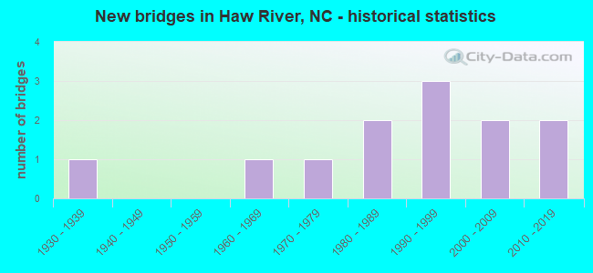
- New bridges - historical statistics
- 11930-1939
- 11960-1969
- 11970-1979
- 21980-1989
- 31990-1999
- 22000-2009
- 22010-2019


- Bridge Condition - Deck
- 22.2%Very good
- 33.3%Good
- 33.3%Satisfactory
- 11.1%Fair

- Bridge Condition - Superstructure
- 33.3%Very good
- 22.2%Good
- 33.3%Satisfactory
- 11.1%Fair

- Bridge Condition - Substructure
- 33.3%Very good
- 11.1%Good
- 44.4%Satisfactory
- 11.1%Poor

- Bridge Condition - Channel
- 10.0%Very good
- 60.0%Good
- 10.0%Satisfactory
- 20.0%Fair
Find on map >> Show street view
Structure Number: 10053, Location: 1.0 MI. N. JCT. SR1740 (Lat: 36.104989, Lng: -79.376942), Route carried "on" structure: State highway 1737, Year Built: 1991, Status: Open, Structure Length: 1.06m (3.48ft), Average Daily Traffic: 2,300 (year 2019), Truck Traffic: 7%, Average Future Daily Traffic: 4,600 (year 2040), Design Load: HS 20+Mod, Features Intersected: BOYDS CREEK
Minimum Vertical Clearance: 30+ m (98+ ft), Kilometerpoint: 0.000, Lanes on structure: 2, Owner: State Highway Agency, Approaching Roadway Width: 7.3m (24.0ft), Skew: 2 degrees, Material/Design: Concrete continuous, Design/Construction: Culvert, Number Of Spans In Main Unit: 3, Length of Maximum Span: 3.0m (9.8ft)
Condition: Channel: Good, Culverts: Good, Operating Rating: 84.3 metric tons, Method Used To Determine Operating Rating: Load and Resistance Factor (LRFR), Inventory Rating: 65.3 metric tons, Method Used To Determine Inventory Rating: Load and Resistance Factor (LRFR), Structural Evaluation: Better than present minimum criteria, Waterway Adequacy: Better than present minimum criteria, Approach Roadway Alignment: Equal to present desirable criteria, Designated Inspection Frequency: Every 24 months, Inspection Date: December 2020
Find on map >> Show street view
Structure Number: 10056, Location: 100 FT. S. JCT. SR1941 (Lat: 36.088772, Lng: -79.368072), Route carried "on" structure: State highway 49, Year Built: 1985, Status: Open, Structure Length: 10.36m (33.99ft), Average Daily Traffic: 6,100 (year 2019), Truck Traffic: 6%, Average Future Daily Traffic: 12,200 (year 2040), Design Load: HS 20+Mod, Features Intersected: HAW RIVER
Minimum Vertical Clearance: 30+ m (98+ ft), Kilometerpoint: 0.000, Lanes on structure: 2, Owner: State Highway Agency, Approaching Roadway Width: 9.4m (30.8ft), Skew: 2 degrees, Material/Design: Prestressed concrete, Design/Construction: Stringer/Multi-beam, Number Of Spans In Main Unit: 5, Length of Maximum Span: 20.1m (65.9ft), Curb-To-Curb Width: 10.9m (35.8ft), Out-to-Out Width: 11.7m (38.4ft)
Condition: Deck: Satisfactory, Superstructure: Satisfactory, Substructure: Satisfactory, Channel: Good, Operating Rating: 84.3 metric tons, Method Used To Determine Operating Rating: Load Factor (LF), Inventory Rating: 32.6 metric tons, Method Used To Determine Inventory Rating: Load Factor (LF), Structural Evaluation: Equal to present minimum criteria, Deck Geometry: Meets minimum limits, Waterway Adequacy: Better than present minimum criteria, Approach Roadway Alignment: Equal to present desirable criteria, Designated Inspection Frequency: Every 24 months, Underwater Inspection Frequency: Every 60 months, Inspection Date: August 2021, Underwater Inspection Date: Febuary 2021, Deck Structure Type: Concrete Cast-file-Place, Wearing Surface/Protective System: Wearing Surface: Monolithic Concrete
Find on map >> Show street view
Structure Number: 10068, Location: 0.05 MI. S. OF JCT. US70 (Lat: 36.092533, Lng: -79.347967), Route carried "on" structure: State highway 1928, Year Built: 1972, Status: Open, Structure Length: 3.53m (11.58ft), Average Daily Traffic: 17,000 (year 2018), Truck Traffic: 7%, Average Future Daily Traffic: 34,000 (year 2040), Design Load: HS 15, Features Intersected: SOUTHERN R.R.
Minimum Vertical Clearance: 30+ m (98+ ft), Kilometerpoint: 0.000, Lanes on structure: 2, Owner: State Highway Agency, Approaching Roadway Width: 8.5m (27.9ft), Skew: 1 degrees, Material/Design: Prestressed concrete, Design/Construction: Slab, Number Of Spans In Main Unit: 3, Length of Maximum Span: 13.4m (44.0ft), Curb-To-Curb Width: 8.9m (29.2ft), Out-to-Out Width: 9.2m (30.2ft)
Condition: Deck: Fair, Superstructure: Fair, Substructure: Poor, Operating Rating: 45.3 metric tons, Method Used To Determine Operating Rating: Load Factor (LF), Inventory Rating: 27.2 metric tons, Method Used To Determine Inventory Rating: Load Factor (LF), Structural Evaluation: Meets minimum limits, Deck Geometry: High priority of replacement, Underclear: Meets minimum limits, Approach Roadway Alignment: Equal to present desirable criteria, Designated Inspection Frequency: Every 24 months, Inspection Date: March 2021, Deck Structure Type: Concrete Precast Panels, Wearing Surface/Protective System: Wearing Surface: Bituminous
Find on map >> Show street view
Structure Number: 10081, Location: 1.2 MI. E. JCT. NC49 (Lat: 36.093475, Lng: -79.335750), Route carried "on" structure: US 70, Year Built: 1938, Year Reconstructed: 2013, Status: Open, Structure Length: 4.02m (13.19ft), Average Daily Traffic: 6,800 (year 2019), Truck Traffic: 6%, Average Future Daily Traffic: 13,600 (year 2040), Design Load: H 15, Features Intersected: BACK CREEK
Minimum Vertical Clearance: 30+ m (98+ ft), Kilometerpoint: 0.000, Lanes on structure: 2, Owner: State Highway Agency, Approaching Roadway Width: 7.3m (24.0ft), Skew: 3 degrees, Material/Design: Concrete, Design/Construction: Tee Beam, Number Of Spans In Main Unit: 3, Length of Maximum Span: 13.7m (44.9ft), Curb or Sidewalk Widths: Left: 0.1m (0.3ft), Right: 0.1m (0.3ft), Curb-To-Curb Width: 7.8m (25.6ft), Out-to-Out Width: 8.9m (29.2ft)
Condition: Deck: Satisfactory, Superstructure: Satisfactory, Substructure: Satisfactory, Channel: Fair, Operating Rating: 33.5 metric tons, Method Used To Determine Operating Rating: Load Factor (LF), Inventory Rating: 19.9 metric tons, Method Used To Determine Inventory Rating: Load Factor (LF), Structural Evaluation: Somewhat better than minimum adequacy, Deck Geometry: High priority of replacement, Waterway Adequacy: Better than present minimum criteria, Approach Roadway Alignment: Equal to present desirable criteria, Designated Inspection Frequency: Every 24 months, Inspection Date: January 2021, Deck Structure Type: Concrete Cast-file-Place, Wearing Surface/Protective System: Wearing Surface: Latex Concrete
Find on map >> Show street view
Structure Number: 10307, Location: 0.95 MI. W. OF JCT. SR198 (Lat: 36.089864, Lng: -79.338242), Route carried "on" structure: State highway 1936, Year Built: 2019, Status: Open, Structure Length: 5.27m (17.29ft), Average Daily Traffic: 2,800 (year 2019), Truck Traffic: 7%, Average Future Daily Traffic: 5,600 (year 2040), Design Load: HL 93, Features Intersected: BACK CREEK
Minimum Vertical Clearance: 30+ m (98+ ft), Kilometerpoint: 0.000, Lanes on structure: 2, Owner: State Highway Agency, Approaching Roadway Width: 6.0m (19.7ft), Material/Design: Prestressed concrete, Design/Construction: Slab, Number Of Spans In Main Unit: 3, Length of Maximum Span: 21.0m (68.9ft), Curb-To-Curb Width: 9.9m (32.5ft), Out-to-Out Width: 10.9m (35.8ft)
Condition: Deck: Very good, Superstructure: Very good, Substructure: Very good, Channel: Good, Operating Rating: 58.0 metric tons, Method Used To Determine Operating Rating: Load and Resistance Factor (LRFR), Inventory Rating: 41.7 metric tons, Method Used To Determine Inventory Rating: Load and Resistance Factor (LRFR), Structural Evaluation: Equal to present desirable criteria, Deck Geometry: Meets minimum limits, Waterway Adequacy: Better than present minimum criteria, Approach Roadway Alignment: Equal to present desirable criteria, Designated Inspection Frequency: Every 24 months, Inspection Date: September 2021, Deck Structure Type: Concrete Precast Panels, Wearing Surface/Protective System: Wearing Surface: Bituminous
Find on map >> Show street view
Structure Number: 10379, Location: 0.6 MI. E. JCT. SR1725 (Lat: 36.095803, Lng: -79.371500), Route carried "on" structure: US 70, Year Built: 1993, Status: Open, Structure Length: 10.08m (33.07ft), Average Daily Traffic: 13,500 (year 2019), Truck Traffic: 6%, Average Future Daily Traffic: 27,000 (year 2040), Design Load: HS 20+Mod, Features Intersected: HAW RIVER
Minimum Vertical Clearance: 30+ m (98+ ft), Kilometerpoint: 0.000, Lanes on structure: 4, Owner: State Highway Agency, Approaching Roadway Width: 15.8m (51.8ft), Skew: 21 degrees, Material/Design: Prestressed concrete, Design/Construction: Stringer/Multi-beam, Number Of Spans In Main Unit: 4, Number Of Approach Spans: 2, Length of Maximum Span: 24.3m (79.7ft), Curb-To-Curb Width: 18.2m (59.7ft), Out-to-Out Width: 19.2m (63.0ft)
Condition: Deck: Satisfactory, Superstructure: Good, Substructure: Satisfactory, Channel: Fair, Operating Rating: 89.8 metric tons, Method Used To Determine Operating Rating: Load Factor (LF), Inventory Rating: 40.8 metric tons, Method Used To Determine Inventory Rating: Load Factor (LF), Structural Evaluation: Equal to present minimum criteria, Deck Geometry: Somewhat better than minimum adequacy, Waterway Adequacy: Better than present minimum criteria, Approach Roadway Alignment: Equal to present desirable criteria, Designated Inspection Frequency: Every 24 months, Inspection Date: August 2021, Deck Structure Type: Concrete Cast-file-Place, Wearing Surface/Protective System: Wearing Surface: Monolithic Concrete, Deck Protection: Epoxy Coated Reinforcing
Find on map >> Show street view
Structure Number: 10433, Location: .2MI.N.JCT.WASHINGTON ST. (Lat: 36.090331, Lng: -79.371981), Route carried "on" structure: City street , Year Built: 2008, Status: Open, Structure Length: 0.76m (2.49ft), Average Daily Traffic: 1,200 (year 2008), Truck Traffic: 7%, Average Future Daily Traffic: 2,400 (year 2040), Design Load: HS 20+Mod, Features Intersected: PERENNIAL STREAM, Facility Carried by Structure: LANG STREET
Minimum Vertical Clearance: 0.00m, Kilometerpoint: 0.000, Lanes on structure: 2, Owner: City or Municipal Highway Agency, Approaching Roadway Width: 5.4m (17.7ft), Material/Design: Concrete, Design/Construction: Culvert, Number Of Spans In Main Unit: 1, Length of Maximum Span: 7.3m (24.0ft), Curb-To-Curb Width: 7.3m (24.0ft), Out-to-Out Width: 8.1m (26.6ft)
Condition: Channel: Satisfactory, Culverts: Good, Operating Rating: 41.7 metric tons, Method Used To Determine Operating Rating: Field evaluation and documented engineering judgment, Inventory Rating: 32.6 metric tons, Method Used To Determine Inventory Rating: Field evaluation and documented engineering judgment, Structural Evaluation: Better than present minimum criteria, Deck Geometry: High priority of corrective action, Waterway Adequacy: Better than present minimum criteria, Approach Roadway Alignment: Equal to present desirable criteria, Designated Inspection Frequency: Every 24 months, Inspection Date: April 2020
Find on map >> Show street view
Structure Number: 970042, Location: 0.5 MI. E. JCT. SR1148 (Lat: 35.545058, Lng: -80.780728), Route carried "on" structure: State highway 1147, Year Built: 1990, Status: Open, Structure Length: 0.70m (2.30ft), Average Daily Traffic: 3,300 (year 2015), Truck Traffic: 6%, Average Future Daily Traffic: 6,600 (year 2040), Design Load: HS 20+Mod, Features Intersected: ROCKY RIVER
Minimum Vertical Clearance: 30+ m (98+ ft), Kilometerpoint: 0.000, Lanes on structure: 2, Owner: State Highway Agency, Approaching Roadway Width: 6.4m (21.0ft), Skew: 2 degrees, Material/Design: Concrete, Design/Construction: Culvert, Number Of Spans In Main Unit: 2, Length of Maximum Span: 3.0m (9.8ft)
Condition: Channel: Good, Culverts: Good, Operating Rating: 41.7 metric tons, Method Used To Determine Operating Rating: Field evaluation and documented engineering judgment, Inventory Rating: 32.6 metric tons, Method Used To Determine Inventory Rating: Field evaluation and documented engineering judgment, Structural Evaluation: Better than present minimum criteria, Waterway Adequacy: Better than present minimum criteria, Approach Roadway Alignment: Equal to present desirable criteria, Designated Inspection Frequency: Every 24 months, Inspection Date: November 2021
Find on map >> Show street view
Structure Number: 970075, Location: 0.9 MI. N. JCT. SR1321 (Lat: 35.678967, Lng: -80.921581), Route carried "on" structure: State highway 1322, Year Built: 1985, Status: Open, Structure Length: 2.52m (8.27ft), Average Daily Traffic: 950 (year 2013), Truck Traffic: 6%, Average Future Daily Traffic: 1,900 (year 2025), Design Load: HS 20+Mod, Features Intersected: HICKS CREEK
Minimum Vertical Clearance: 30+ m (98+ ft), Kilometerpoint: 0.000, Lanes on structure: 2, Owner: State Highway Agency, Approaching Roadway Width: 5.1m (16.7ft), Skew: 3 degrees, Material/Design: Prestressed concrete, Design/Construction: Slab, Number Of Spans In Main Unit: 2, Length of Maximum Span: 11.8m (38.7ft), Curb-To-Curb Width: 7.5m (24.6ft), Out-to-Out Width: 8.3m (27.2ft)
Condition: Deck: Good, Superstructure: Good, Substructure: Good, Channel: Good, Operating Rating: 62.5 metric tons, Method Used To Determine Operating Rating: Load Factor (LF), Inventory Rating: 37.1 metric tons, Method Used To Determine Inventory Rating: Load Factor (LF), Structural Evaluation: Better than present minimum criteria, Deck Geometry: Meets minimum limits, Waterway Adequacy: Better than present minimum criteria, Approach Roadway Alignment: Equal to present desirable criteria, Designated Inspection Frequency: Every 24 months, Inspection Date: Febuary 2020, Deck Structure Type: Concrete Precast Panels, Wearing Surface/Protective System: Wearing Surface: Bituminous
Find on map >> Show street view
Structure Number: 970079, Location: 0.6 MI. W. JCT. SR1338 (Lat: 35.750628, Lng: -80.918694), Route carried "on" structure: State highway 1337, Year Built: 2012, Status: Open, Structure Length: 2.83m (9.28ft), Average Daily Traffic: 730 (year 2017), Truck Traffic: 6%, Average Future Daily Traffic: 1,460 (year 2040), Design Load: HL 93, Features Intersected: BACK CREEK
Minimum Vertical Clearance: 30+ m (98+ ft), Kilometerpoint: 0.000, Lanes on structure: 2, Owner: State Highway Agency, Approaching Roadway Width: 8.2m (26.9ft), Skew: 3 degrees, Material/Design: Prestressed concrete, Design/Construction: Slab, Number Of Spans In Main Unit: 2, Length of Maximum Span: 19.5m (64.0ft), Curb-To-Curb Width: 8.2m (26.9ft), Out-to-Out Width: 9.1m (29.9ft)
Condition: Deck: Very good, Superstructure: Very good, Substructure: Very good, Channel: Very good, Operating Rating: 52.6 metric tons, Method Used To Determine Operating Rating: Load and Resistance Factor (LRFR), Inventory Rating: 39.9 metric tons, Method Used To Determine Inventory Rating: Load and Resistance Factor (LRFR), Structural Evaluation: Equal to present desirable criteria, Deck Geometry: Somewhat better than minimum adequacy, Waterway Adequacy: Better than present minimum criteria, Approach Roadway Alignment: Equal to present desirable criteria, Designated Inspection Frequency: Every 24 months, Inspection Date: Febuary 2022, Deck Structure Type: Concrete Precast Panels, Wearing Surface/Protective System: Wearing Surface: Bituminous
Find on map >> Show street view
Structure Number: 970086, Location: 0.9 MI. E. JCT. US70 (Lat: 35.725542, Lng: -81.024647), Route carried "on" structure: State highway 1333, Year Built: 2009, Status: Open, Structure Length: 3.81m (12.50ft), Average Daily Traffic: 690 (year 2012), Truck Traffic: 6%, Average Future Daily Traffic: 1,380 (year 2040), Design Load: HS 25 or greater, Features Intersected: BUFFALO SHOALS CREEK
Minimum Vertical Clearance: 30+ m (98+ ft), Kilometerpoint: 0.000, Lanes on structure: 2, Owner: State Highway Agency, Approaching Roadway Width: 8.5m (27.9ft), Material/Design: Steel, Design/Construction: Stringer/Multi-beam, Number Of Spans In Main Unit: 1, Length of Maximum Span: 36.8m (120.7ft), Curb-To-Curb Width: 9.3m (30.5ft), Out-to-Out Width: 10.4m (34.1ft)
Condition: Deck: Good, Superstructure: Very good, Substructure: Very good, Channel: Good, Operating Rating: 76.2 metric tons, Method Used To Determine Operating Rating: Load Factor (LF), Inventory Rating: 45.3 metric tons, Method Used To Determine Inventory Rating: Load Factor (LF), Structural Evaluation: Equal to present desirable criteria, Deck Geometry: Equal to present minimum criteria, Waterway Adequacy: Better than present minimum criteria, Approach Roadway Alignment: Equal to present desirable criteria, Designated Inspection Frequency: Every 24 months, Inspection Date: March 2020, Deck Structure Type: Concrete Cast-file-Place, Wearing Surface/Protective System: Wearing Surface: Monolithic Concrete
Find on map >> Show street view
Structure Number: 970105, Location: 0.1MI.N.JCT.US21 & NC115 (Lat: 35.676119, Lng: -80.855381), Route carried "on" structure: Interstate 77, Year Built: 1968, Status: Open, Structure Length: 4.84m (15.88ft), Average Daily Traffic: 29,750 (year 2018), Truck Traffic: 23%, Average Future Daily Traffic: 59,500 (year 2040), Design Load: HS 20+Mod, Features Intersected: SOUTHERN RR (ABANDONED)
Minimum Vertical Clearance: 30+ m (98+ ft), Kilometerpoint: 12.746, Lanes on structure: 2, Base Highway Network: Yes (Inventory Route: 1, Subroute: 77), Owner: State Highway Agency, Approaching Roadway Width: 11.2m (36.7ft), Skew: 13 degrees, Material/Design: Prestressed concrete, Design/Construction: Stringer/Multi-beam, Number Of Spans In Main Unit: 3, Length of Maximum Span: 15.5m (50.9ft), Curb-To-Curb Width: 12.2m (40.0ft), Out-to-Out Width: 12.8m (42.0ft)
Condition: Deck: Good, Superstructure: Satisfactory, Substructure: Satisfactory, Operating Rating: 89.8 metric tons, Method Used To Determine Operating Rating: Load Factor (LF), Inventory Rating: 57.1 metric tons, Method Used To Determine Inventory Rating: Load Factor (LF), Structural Evaluation: Equal to present minimum criteria, Deck Geometry: Better than present minimum criteria, Approach Roadway Alignment: Equal to present desirable criteria, Designated Inspection Frequency: Every 24 months, Inspection Date: May 2020, Deck Structure Type: Concrete Cast-file-Place, Wearing Surface/Protective System: Wearing Surface: Epoxy Overlay